#JOsM
Text
La Joven Orquesta sierra de Madrid y la Asociación de Desarrollo Sierra de Guadarrama firman un convenio para potenciar la cultura musical y el turismo

View On WordPress
#ADESGAM#Cultura#Guadarrama#Javier Hermosa#JOsM#Joven Orquesta Sierra de Madrid#la Asociación de Desarrollo Sierra de Guadarrama#Sierra Noroeste
0 notes
Video
youtube
josm حل مشكلة تكرار المباني في تاكد انك مشترك في القناة 💯 ومفعل الجرس عشان يوصلك كل جديد 🔔 وما تنساش تعمل لايك للفيديو 👍 نشرك للمقطع هو اكبر دعم ممكن تقدمه لي ... أتمنى أن ينال الشرح أعجابكم ...................................................................... https://bit.ly/3N9F3OH https://bit.ly/3ux7pwI شير مشاركة #BIMarabia اشترك في القناة لمتابعة الشروحات الجديدة videos https://www.youtube.com/channel/UCZYaOLTtPmOQX1fgtDFW52Q?sub_confirmation=1 بيم ارابيا https://bit.ly/1TSqEbr ❤️ رابط الاشتراك في القناة https://www.youtube.com/channel/UCZYaOLTtPmOQX1fgtDFW52Q?sub_confirmation=1 ❤️ روابط التواصل ✅ انستجرام https://bit.ly/2JY3wZP ✅ الفيسبوك https://bit.ly/3AcrQBO ✅ تويتر https://twitter.com/bimarabia ✅ لينكد ان https://bit.ly/2nqASDv ✅ قناة التلجرام https://bit.ly/3bu9Pod ✅ الموقع الالكتروني الشخصي https://bit.ly/3N9F3OH https://bit.ly/3suwyqU https://bit.ly/3bEr3zh October 4, 2022 at 04:51AM by Omar Selim BIMarabia عمر سليم بيم ارابيا
0 notes
Text

Tur Ghore Chur Sundhaiche - Rishi Chakraboty Song - Best Bengali Folk Song - Jhumur Song - @rishifolk
Full Song Link:
https://www.youtube.com/watch?v=RQY6u8-josM
If you're a fan of Bengali folk music, then you need to check out this song! The Tur Ghore Chur Sundhaiche - Rishi Chakraboty song is one of the most popular and beloved Bengali folk songs. The song is beautifully sung and is sure to bring a smile to your face. Thank you for supporting Rishi Chakraborty and his music!
🌟 Credits:
Song - Tur Ghore Chur Sundhaiche - তুর ঘরে চুর সুন্ধাইছে ,
Singer - Rishi Chakraborty,
Music Arrangement - Amit Sur,
Programming - Sainik Dey,
Studio Partner - Studio Violina,
Flute - Soumyajyoti Ghosh,
Rhythm - Mriganavi Chattyapaddhaya & Sudipto Chakraborty,
Percussion - Somnath Roy,
Chorus - Tuhina Deb, Sayani Naiya, Nilam Dutta, Amit Sur, Raghunath Roychowdhuri,
Mixed & Mastered by - Tarun Das @ Studio Violina
DOP - Sangeet Roy,
Editing Desk - Third Eye Malda,
Thumbnail - Gopal Kirtania,
Special Thanks to - Prajna Dutta, Devoleena Maittraa, SNK-Su-Nritya Kala,
Song collected by - Joy Thakur,
Language - Bangla,
Category - Folk Song,
Digital Advisor - Sanjay Sen,
Label - Rishi Folk
🌟 Previous Released:
https://www.youtube.com/watch?v=PBHwnjOUepA
https://www.youtube.com/watch?v=AlMAq0_dOjg
https://www.youtube.com/watch?v=_PdBJmsjiOw
https://www.youtube.com/watch?v=OMR6D7Y5YVs
https://www.youtube.com/watch?v=t3KU-kjfJZs
🌟 My Social Media Handle & Digital Marketing Partner:
Visit My Google Site: https://bit.ly/Rishi_Folk
Follow me on YouTube: https://bit.ly/RishiFolk
Follow me on Facebook: https://bit.ly/Rishifolk
Follow me on Instagram: https://bit.ly/rishifolk
Follow me on Twitter: https://bit.ly/Rishi-Folk
Follow me on LinkedIn: https://bit.ly/rishiFolk
Digital Marketing Partner: https://bit.ly/ViolinaWebservicesPvtLtd
🌟 Hash Tag:
bengalifolk #rishifolksong #newfolksong #rishifolk #newbengalisong #folkmusic #bengali #folk #baulgaan #bengalisong #indianfolk #facebook #fb #facebookstatus #likesback #followme #bengaliculture #folksongs #kolkatasong #liveperformance #indianband #worldmusic #bengalimusic #music #bengalidance #status #song #singer #folksong #dotara #damsa #madol #kolkatamusic #puruliasong #rootmusic #unplugged #kalikaprasad #facebookpage #facebookpost #facebookme #bengalifolksong
2 notes
·
View notes
Text
Moving the JOSM plugin repository from svn to git
https://www.openstreetmap.org/user/vorpalblade/diary/403099
0 notes
Text
male portuguese forenames
Aarlomaz Aartino Adaspardo Adatano Adrano Adrasão Adremino Adricobe Alano Alanordo Alaulio Alavo Alberiano Alcel Alchico Alciandio Alciano Alcionso Aldio Aleno Alenço Alfon Alfrene Alfrenei Almigo Almião Amano Ambrian Ambricino Ambrónio Amândrio Amérias Andio Andomão Andrano Andrica Andrino Andrio Andristas Andro Andão Anteriso Antim Antino Antintião Antônico Aparcidor Aparo Aquias Aquimo Armar Armarcio Armim Armino Armínim Arnélio Arnésim Arque Arses Arseu Arseustão Artoro Aílio Aíliverto Aílta Aírtiago Aírtimeu Aírto Basco Bathano Belio Beneino Beneiro Bradas Bradato Bradestão Brando Branto Brenjamés Brássio Caelinho Caelo Caelsonso Caete Caldovio Calto Camiastão Camiro Camés Carcio Casaro Cassim Castisto Celcio Clóvidato Contino Coriagos Crias Crigo Crino Cásseu Cândino Cândranio Cândro Césio Damino Damiro Damés Davio Delistão Deodo Deonal Deonstino Diros Domão Dontim Duarcises Duardo Duareno Duario Duarto Dudor Durcionto Décidorio Edmue Edmuno Edsonas Egídito Emílica Emínideu Emínio Enricomo Enrino Enrio Esdro Esdróniel Estano Estasco Estias Estim Expedeão Expedré Ezequeiro Ezequel Ezequian Fabio Fabria Fabrio Fabrónio Faulion Fauro Felcio Ferino Fermeus Fernan Ferto Filso Floman Flácian Flário Frano Fábiando Félico Félino Félixo Gabianso Gabio Galtavis Gasparceu Gidomião Gonaldo Gonrando Gonso Gonsão Gonçalber Grecid Gualdo Guartino Guilso Guilveiro Guinho Gustão Guálta Guálte Guálto Guáltéri Helicas Heliverio Heloro Henaldito Henardo Henio Heriano Hilvio Hugus Inácido Isaacó Isarcio Isardo Isaro Isartim Isaíastim Jaimeno Jaimino Jaimão Jaircel Jardo Jastandro Jerique Jernão Joalteus Jonrigio Jonçalte Joreno Jorisco Josme Josmedeão Jucinho Jucio Juduales Juliago Julino Julio Justano Justimue Justão Jácio Jácius Jácosmeão Júlives Leandão Lenionto Leodeão Leodo Leonstias Leopolano Leófiro Leónio Lotárcio Lotáricio Lourco Lourcusto Louro Lucardo Lucarosué Lucidério Lucio Lucion Ludor Luduario Luias Luimo Líviel Lívisto Lúcinho Lúcino Lúciso Mandré Marciano Marcida Marcino Marcio Marcob Marcustim Mardo Mardorge Marias Marico Marissime Martino Marto Marão Matando Matano Mataviel Mator Matrino Matrício Mausto Maximeão Maximo Migio Migue Mique Miquelos Miquiz Modes Modor Modósio Moisco Márco Márias Márino Máximinto Narco Nardo Natas Niciano Nicior Nicto Nundid Nundo Nundão Nésimo Néstano Néstoriel Odide Odino Olano Olavis Olino Oliso Onéliano Onélio Paoldito Pasard Pasco Pathalomé Pator Patrícia Paulias Pausto Paustêvão Pedeu Peditor Pedovisto Plárian Plávico Plávinho Quiel Quielso Quilon Quilvio Quilácio Quilávine Quimil Quingo Quintiano Radamuno Raior Rairo Ramiasim Raustor Raymino Raymir Raymiro Raymião Reiantino Reixo Remiro Ricarcob Ricarto Ricob Ricto Roberton Roberónas Rocleiro Rocles Roclexan Rocquiro Rodastão Rodrigus Rodósim Rodósio Rogérge Rogérique Romaz Romão Romés Ronal Ronaro Ruielino Saldo Sales Saltério Samão Saméstas Saméstime Sanoel Saulinte Saurceu Sebano Seberio Setas Setavinal Setavo Seteu Sevei Seveix Seveixo Severme Severte Silso Silsonço Silvaro Silvido Silvidor Simueiro Sérco Teodo Teodré Teonstimo Teopolo Teófimão Teónido Thaldo Thansão Thiasto Thico Thicto Tiano Tibur Tiburo Tomano Tomilio Tomiro Tomão Trico Trino Triquei Térge Tériano Tério Uliago Ulrino Ulrio Ulriocqui Ulrisseu Urbandros Uricobe Uriso Valdo Valeixo Victo Vinho Xavio Zefer Zeferturo Zéfil Zéfim Álvardo Éricio Óriantor Óriasão
0 notes
Text
Linux gpx editor

LINUX GPX EDITOR HOW TO
LINUX GPX EDITOR SOFTWARE
LINUX GPX EDITOR FREE
LINUX GPX EDITOR WINDOWS
Create and discuss ideas and enhancements as ticket and contact the team.
Please report any bug found! Via the Report Bug form in the Help menu it is easy.
Summarized changelog (nicely summarized)įound a bug? | Have an idea? | Make a suggestion? | Like to contribute?.
Backgrounds allow you to trace osm data from e.g.
Styles change the appearance of the mapview.
Presets allow you to select predefined tags for objects.
Plugins add more complex program features.
the OSM IRC channel, including our own room.
OpenStreetMap's question-and-answer site.
Ask members of the OpenStreetMap community on.
See the official help system – reaches it everywhere on JOSMs interface and the help button in dialogs.
The Introduction page will guide you to your first successful edit.
LINUX GPX EDITOR HOW TO
Preferred distribution channel, all platforms, monthly automatic update ( how to start changelog)ĭevelopment version (version 18556, josm-latest.jnlp or josm-latest.jar), macOS dev builds, Ubuntu repository and all Download options. Start josm.jnlp (newest tested version, currently 18543) JOSM is open source and licensed under GPL . It supports loading GPX tracks, background imagery, and OSM data from local sources as well as from online sources and allows to edit the OSM data (nodes, ways, and relations) and their metadata tags. if its not on this map, its not legal to ride.JOSM is an extensible editor for OpenStreetMap (OSM) for Java 8+. forest_park_trail_map_070711.pdf High Quality TOPO map of all trails in Forest Park.Some of these I have used or tried, the majority I have not.
LINUX GPX EDITOR FREE
I'm certain there are more feel free to add your favorite. TopOSM, an OpenStreetMap-based topographic map, similar in style to the USGS and National Geographic topographic maps., Free topo maps for print and your GPS device., upload your GPX to chart elevation gain/loss, speed, etc., create an editable route to share via email and download as GPX, measure slope angle.Google Earth, what? your not using this already.?., the ULTIMATE GPS file translator filetype converter utility.
LINUX GPX EDITOR WINDOWS
, EasyGPS is the fast and easy way to upload and download waypoints, routes, and tracks between your Windows computer and your Garmin, Magellan, or Lowrance GPS.
LINUX GPX EDITOR SOFTWARE
, proprietary software with GPX output.
Prune, GpsPrune is a free/open source application for viewing, editing and converting coordinate data from GPS systems.
Viking, Viking is a free/open source program to manage GPS data.
*edit to add the following list of electronic mapping applications. I find this one of the most useful utilities for route planning, especially ski touring or anything off trail. note you have a DL option as either a route or track file, the latter showing up on your device as a continuous line. Created routes can be downloaded as a track in a GPX file for use in a GPS device. super simple and editable routes can be shared via email. at the very least I want to view my track on a decent topo map but never get the one I want.Īdding to the browser mapping utility list. I have that one bookmarked and use occasionally, but find it not user friendly for my simple needs. There are a handful of mapping browser utilities out there now like GPSVisualizer. especially all those old NG TOPO! files into GPX. GPSBabel saves the day when it comes to file conversions. but it does not run on linux which I use. Personally, the best I have found is Topofusion. That exact reason is why I started looking for other mapping solutions. Pablo wrote:Slightly off topic but I just ran into the problem of NG TOPO! not exporting tracks in GPX.
0 notes
Text
Datacrow java runtime environment

#Datacrow java runtime environment Pc
#Datacrow java runtime environment windows
Right-click the created shortcut and select properties.You can also use "Send to > Desktop (create shortcut)". Click "Create shortcut" on the context menu. bat file, a command terminal opens and do the commands on the. It is recommended to use "cd" command before "java" command to specify the default running directory. Open a text editor (for example, notepad) and create a new file by it.To add options, you can choice from two ways.
#Datacrow java runtime environment windows
It is special for Windows to run Java GUI applications without terminals.) command. jar file type to be run by javaw.exe (which is another java running command. Usually, the JRE installer registers the.
Go to ~/Applications/Utilities in Finder.
Open Spotlight ⌘ Cmd + Space and search for "terminal".
Alternatively use ⊞ Win + R and enter "cmd" in the Run window.
Open the start menu and search for "cmd".
Open the start menu and search for "terminal".
How to access command terminals on different operating systems. Font rendering options eSystemAAFontSettings=on -Dswing.aatext=true Enables anti-aliasing. 3d=true =true Enabling DirectX graphic acceleration for Windows. tested on WinXP + nVidia FX1500 + dual monitor) use: =true =false although note that the opengl option can cause problems with window managers on Linux. If you have problem with this setting (false icon and background, dialog.
#Datacrow java runtime environment Pc
Specify it if you know your PC has OpenGL 2D graphic accelerators. Graphic acceleration options =true Enabling OpenGL. 6Addresses=true Specify it if you need IPv6. Set it if the proxy server requires authentication. Dhttp.proxyPassword= specifies proxy password. For example: -Dhttp.proxyHost=8080 -Dhttp.proxyUser= specifies proxy username. For example: -Dhttp.proxyHost=192.168.1.1 -Dhttp.proxyPort= specifies a proxy port. Proxy options -Dhttp.proxyHost= specifies a proxy server if you want to use http though a proxy server. Increase it to, for example, 512 MB with the option -Xmx512m. The default value is 64 MB which is often too small. This is the maximum memory capacity of the Java application. Memory options -Xmx is the only memory option which really matters. See Java documentation for more information. The following are commonly used options for the Java VM. For example, for to run JOSM, type commands like this: It's not so hard even if you don't have any experience of command lines. Some Java applications (for example, mkgmap.jar) cannot run without terminals. This way is a more basic fundamental approach which you can use on any operating system. Think twice before you set up your system to start jar files automatically by just clicking-this would work with all downloaded jar files then (also with accidental, malicious downloads)! Better use the command line or a manually built link/script. Firstly, you'll need Java installed as detailed above, and with the necessary operating system hooks enabled, and these may not be available for some operating systems. The file contains details of which Java class files to run by default, and the application just starts up. This means you can simply double-click the file on many operating systems.
0 notes
Text
Maps 3d gps tracks

MAPS 3D GPS TRACKS HOW TO
MAPS 3D GPS TRACKS FREE
GPS Utility to manage, manipulate and map your GPS information.
GPS TrackMaker (Windows) allows GUI editing of gpx tracks (e.g.
MAPS 3D GPS TRACKS FREE
GPS Track Editor is a free Windows desktop application for analysing and editing tracks and trackpoints (split/merge/filter).It allows you to split/merge/move tracks, edit routes, detect and remove GPS errors and add coordinates to images. TrackProfiler is an online GPS track editor.Trakclean (discontinued) is a simple Windows console application to eliminate spurious trackpoints (typically recorded when stationary) using a minimum speed or distance criterion.Merge Tool and Anonymize Tool are two small console applications (for Windows) to merge gpx files or randomly shift their timestamps.gpx_reduce is a small python script that yields high-quality gpx-track reduction/compression.It's useful for GPS units (such as those based on MTK chipsets) that munge tracks and waypoints together. gpxsplitter splits multi-track GPX files, containing waypoints, into individual one-track GPX files with their respective waypoints.Displays information about the number of routes, routepoints, waypoints and tracks, tracksegments, trackpoints in a GPX-file. GPX Editor is a free Windows desktop application for splitting, joining and pruning of trackpoints, visualises tracks in Google Maps, simplifies tracks using various methods etc.Florb is a really simple map viewer and GPX editor written in C++.Offers five options to prune trackpoints from the track, like removal of duplicate trackpoints. GpsPrune is a free Windows desktop application for visualising (2D, 3D, osm, Google Earth) and editing GPX files.gpsman is very useful if you can see past the unusual tcl/tk user interface.Check Perl_Scripts#osmtrackfilter and for some command line tools.RouteConverter is a free and open source Java desktop application for displaying, editing and converting routes, tracks and waypoints in CSV, KML, KMZ, GPX and NMEA-files.Viking,, project allows visualizing, editing and uploading tracks to OSM.Elevation and metadata is preserved since JOSM version 14163. By converting the GPX layer to a data layer, it can be edited, then saved again as a GPX file, or directly uploaded to OSM using EditGpx plugin. JOSM permits reading and writing GPX files.Some of these only work on waypoints, so you may have to convert a track to waypoints and back (gpsbabel allows this). It provides filters (see using filters with GPSBabel). GPSBabel is a free Windows/Linux/MacOS desktop application for converting GPS traces between various data formats.GpsMaster is a free and open source Java desktop application for creating, viewing, editing and analysing GPX-files.to delete sections of data which have already been uploaded or are not relevant.compress a track to reduce the number of points and speed up uploading.To reduce the data volume, you may want to :.This allows more accurate tagging of the uploaded logs. For instance, separate the flight log and the bus trip from the airport. You may want to split your logs into parts depending on some criteria.speeds higher than 300 km/h lower than 1 km/h (values can be computed by gpsbabel).distance between trackpoints more than 500 m,.If the receiver produced implausible results:.Also, if you spent a while at some place, the resulting cloud of points is not that useful for mapping.You may want to remove points where your GPS receiver had poor reception (say you were inside a building).To improve the remove or correct bad data:.
MAPS 3D GPS TRACKS HOW TO
You may want to exclude the area around your house ( Using filters with GPSBabel shows how to do that with gpsbabel) and possibly modify the timestamps. This can give people a lot of information you don't want them to have.
Your GPS tracks can reveal your exact address and show when you were where.
In particular, don't edit the locations of trackpoints, just remove bad ones and split the tracks as required.
OSM is interested in the raw data, so you shouldn't edit your tracks to match what you would like to see mapped.
You should only upload raw data you collected yourself in the real world.
If you followed the conversion step before now, the track log should be in GPX file format. Global Navigation Satellite System Tracelogįor a variety of reasons, you may want to edit a GPS track log before uploading it to OSM.
0 notes
Photo
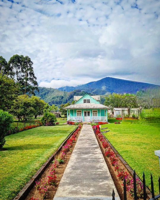
Tantas veces pasé por aquí... Viví casi 2 años entre Oxapampa y Pozuzo y esta bella casa con sus áreas verdes, siempre atrajo mi atención. (en Oxapampa) https://www.instagram.com/p/ChmM--JOSM-/?igshid=NGJjMDIxMWI=
0 notes
Photo
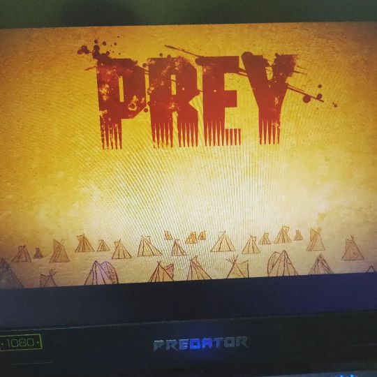
#FridayNightFrights is #Prey with a serving of @onlypanspoblacion https://www.instagram.com/p/ChKF5X-JOSM/?igshid=NGJjMDIxMWI=
0 notes
Text
josm حل مشكلة تكرار المباني في
josm حل مشكلة تكرار المباني في
https://youtu.be/A6K_WWw1wpc تاكد انك مشترك في القناة 💯 ومفعل الجرس عشان يوصلك كل جديد 🔔 وما تنساش تعمل لايك للفيديو 👍
نشرك للمقطع هو اكبر دعم ممكن تقدمه لي …
أتمنى أن ينال الشرح أعجابكم
…………………………………………………………….
https://ift.tt/USlLmob
https://ift.tt/EQVhFGJ
شير مشاركة #BIMarabia
اشترك في القناة لمتابعة الشروحات…
View On WordPress
0 notes
Text

Amito Bhala Na - Rishi Chakraboty & Adriz Ghosh - Bengali Folk Song - @Rishi Folk
Full Song Link:
https://www.youtube.com/watch?v=GvHqdb_2PLE
In "Amito Bhala Na," Rishi Chakraboty beautifully portrays the bittersweet emotions of unrequited love.The song weaves a tale of longing, melancholy, and the pain of loving someone who does not reciprocatethose feelings. With his heartfelt rendition, Rishi Chakraboty effortlessly captures the essence of thefolk song, resonating with listeners on a deep emotional level.
✨ Credits:
Song Name: Amito Bhala Na - আমিতো ভালা না,
Lyrics & tune: Titu Pagol,
Singer & Music Director: Rishi Chakraborty,
Arrangement: Soummya Chakraborty & Adriz Ghosh,
Banjo / Dotara: Amit Sur,
Mixed & Mastered: Tarun Das @Studio Violina,
Video Direction: Rishi Chakraborty,
Camera Works: Ayan Bhattacharyya,
Editing Desk: Third eye Malda,
Special Thanks: Ayan Bhattacharyya & Sangeet Roy,
Language: Bangla,
Category: Folk Song,
Digital Advisor: Sanjay Sen,
Label: Rishi Folk
✨ Previous Released:
https://www.youtube.com/watch?v=2G_2NDO226k
https://www.youtube.com/watch?v=osbjqhFLi88
https://www.youtube.com/watch?v=RQY6u8-josM
https://www.youtube.com/watch?v=PBHwnjOUepA
https://www.youtube.com/watch?v=AlMAq0_dOjg
https://www.youtube.com/watch?v=_PdBJmsjiOw
https://www.youtube.com/watch?v=OMR6D7Y5YVs
https://www.youtube.com/watch?v=t3KU-kjfJZs
✨ My Social Media Handle & Digital Marketing Partner:
Visit My Google Site: https://bit.ly/Rishi_Folk
Follow me on YouTube: https://bit.ly/RishiFolk
Follow me on Facebook: https://bit.ly/Rishifolk
Follow me on Instagram: https://bit.ly/rishifolk
Follow me on Twitter: https://bit.ly/Rishi-Folk
Follow me on LinkedIn: https://bit.ly/rishiFolk
Digital Marketing Partner: https://bit.ly/studio-violina
✨ Hash Tag:
bengalifolk #rishifolksong #newfolksong #banglagaan
1 note
·
View note
Text
because there are like 10 west wing fans on here and only 3 of us think sam and josh had chemistry so they don’t have a ship name i’ve decided to give them one,, to the two other people on here their ship name is leaborn now
#making a ship name is hard ok#especially when their names are as generic as sam and josh#the generator i used had some funny combos so#other contenders include:#sosh#lymaborn#josm#lynborn#and seaboran#anyway to my followers rip you i guess sorry for putting this on your dash#should i tag the hell out of this?#why not#the west wing#tww#josh lyman/sam seaborn#sam seaborn#josh lyman#josh lyman x sam seaborn
39 notes
·
View notes
Text
Elevate Your JOSM Experience on MacOS with Dark Mode
https://www.openstreetmap.org/user/darkonus/diary/402271
0 notes
Photo

@llth-angel @josme-cat @prinzess-devil @maybeitwasmymistake
2 notes
·
View notes
Text
Die Karte bearbeiten
Heute zeige ich euch, auf was es beim Bearbeiten von OpenStreetMap ankommt.
Als erstes muss man sich kostenlos registrieren, schließlich müssen die Änderungen an der Karte ja auch nachvollziehbar sein. Dazu klickt man auf der Seite https://www.openstreetmap.org/ rechts oben auf „Registrieren“ und gibt einen Benutzernamen, Emailadresse und Passwort an. Nach Bestätigung des Kontos ist man nun bereit.
Um einen neuen Karteninhalt zu erzeugen, sind einige Schritte notwendig. Natürlich muss man erst einmal Daten aufnehmen („mappen“). Das können Luftbilder (Orthofotos) sein oder auch mit dem GPS aufgenommene Positionsdaten (sogenannte GPS-Tracks). Man kann Daten aber auch mittels Skizzen notieren. Lokales Wissen ist ebenfalls sehr wertvoll. Zum Beispiel kann man auch Zusatzinformationen wie Öffnungszeiten zu den Kartenobjekten hinzufügen. Wichtig ist darauf zu achten, dass man nicht von anderen Quellen abzeichnet (z.B. von Google Maps) und keine Urheberrechtsverletzungen begeht.
Als nächstes muss man ein Bearbeitungsprogramm auswählen. Es gibt Offline-Editoren wie z.B. JOSM und auch Editoren für Mobilgeräte (z.B. „StreetComplete“). Ich habe mich für einen Online-Editor entschieden, und zwar „iD“. Das ist das Programm das aufgerufen wird, wenn man auf der OpenStreetMap-Seite auf „Bearbeiten“ klickt.
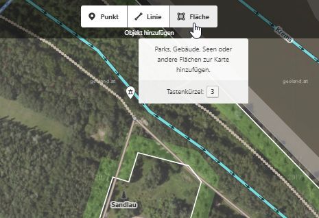
Jetzt kann man die Karte bearbeiten und die Daten einzeichnen. Eingefügt werden Punkte, Linien oder Flächen, es gibt auch noch geschlossene Linienzüge wie beispielsweise Kreisverkehre. Die selbst gesammelten Daten wie Luftbilder oder GPS-Tracks können nicht direkt in die Karte eingefügt werden, diese werden nur zum Einzeichnen hinterlegt.
Hat man neue Objekte in der Karte erstellt, ist es auch noch wichtig Eigenschaften hinzuzufügen, sogenannte Attribute („tags“). Dies kann z.B. die Art des Objekts sein (Straße, Wald, Gewässer,…), Klassifizierungen (z.B. die Straße ist eine Autobahn --> „highway = motorway“) oder Zusatzinformationen wie beispielsweise Einschränkungen (Tempolimit, Einbahnstraße,…) und Namen.
Wenn man mit dem Bearbeiten fertig ist, kann man nun die Daten in die Map hochladen. Zum Abschluss muss man die Änderungen in der Map beschreiben, damit nachvollziehbar ist, was sich geändert hat. Ist man unsicher, ob man alles richtig gemacht hat, kann man auch andere Bearbeiter um eine Überprüfung bitten. Es dauert ein bisschen bis die Daten veröffentlich werden (bis zu einer halben Stunde ungefähr).
Wie im letzten Beitrag erwähnt, kann man dann auch eine Karte erzeugen. Es sind verschiedene Kartenebenen verfügbar, wie zum Beispiel Luftbilder von verschiedenen Quellen oder auch eine topographische Karte (OpenTopoMap).
Zu OpenStreetMap gibt es auch ein umfangreiches Wiki. Wenn ihr noch nähere Informationen zum Einstieg benötigt, werdet ihr hier fündig:
https://wiki.openstreetmap.org/wiki/DE:Beginners%27_guide
Nach der ganzen Einführung habe ich das Bearbeiten gleich mal ausprobiert. Zufällig ist mir in der Karte ein Fehler aufgefallen, ein Gebäude in der Nähe meines Zuhauses wurde falsch als Einfamilienhaus klassifiziert. Da ich dort manchmal vorbeikomme, weiß ich aber, dass dort eine Scheune steht und kein Haus. Die Korrektur geht sehr schnell, einfach das Objekt anklicken und dann im Menü links mit einem Klick auf Objekttyp den Typ auf „Scheune“ ändern (=barn). Ich habe dann noch eine kurze Beschreibung hinzugefügt, dass das sicher eine Scheune ist und dann die Änderung hochgeladen.
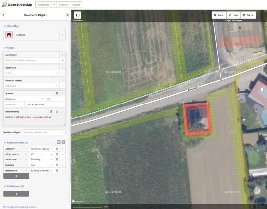
Umklassifizierung des Gebäudes
1 note
·
View note
Last Seen Blogs

faintaint
go figure

takahisasiko
見られ好き

cassiesclothes
Cassiesclothes

xchrixy
???

chvnhell
IG @chvnhell