#asaam hashtag
Text
Floods in Assam: Causes and Potential Solutions
Assam is a place beyond the tea gardens, silk, one-horned rhinos and blue hills. This beautiful Northeastern state of India is also blessed with fertile land by the mighty river Brahmaputra and Barak river. The state has always mesmerized the people through its beauty and resources but what we don’t know is the suffering of the people which they undergo every year due to the impact of the flood. As a mainland citizen of Assam, I have been watching since my childhood “the floods” affecting the lives of people and there is no improvement to the situation. The Brahmaputra and Barak Rivers, which are fed by more than 50 tributaries, cause flood devastation every year during the monsoon season. The vast network of these rivers makes it vulnerable to natural disasters such as flooding and erosion, which has a negative impact on the state's overall development.
“According to the Rashtriya Barh Ayog (RBA), the state's flood-prone area is 31.05 lakh hectares, compared to the state's total area of 78.523 lakh hectares, or about 39.58 percent of Assam's total land area. This represents about 9.40 percent of the country's total flood-prone area. According to records, floods affect an average of 9.31 million hectares per year. The flood-prone area of the country as a whole is about 10.2 percent of the total area, but Assam's flood-prone area is 39.58 percent of the state's total area. It means that Assam's flood-prone area is four times the national average for flood-prone areas in the country.”
As most people are aware, flooding has direct consequences, such as loss of life, property damage, crop devastation, livestock loss, and deterioration of health due to waterborne infections. Some economic activity may come to a halt as communication linkages and infrastructure such as power plants, highways, and bridges are damaged or interrupted, forcing people to flee their homes and disrupting regular life.
The major drawback comes to the livelihood of people who solely depend on agriculture. The farmers lose the majority of their crops and during these difficult times, farmers require an extra dosage of patience and perseverance. Floods overall decrease agricultural production as well as productivity which hampers economic growth.
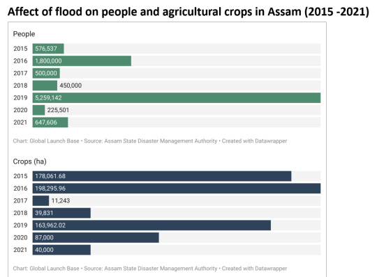
The following graphs show how vastly the people of Assam get affected by floods each year from 2015 - 2021 which also destroy the agricultural crops, an income source for many.
Reasons behind Assam floods:
The floods in Assam are mainly caused by the following factors:
The annual rainfall of 2480 mm is received by the Brahmaputra and as well as the 6350 mm in the northeastern hills during the monsoon period, causing the rise in the water level.
The Brahmaputra valley falls under Zone V which is subjected to frequent seismic activities and increases the chances of floods.
The geographical areas of Assam are prone to natural disasters as the areas are surrounded by hills. Thus, the snow melted and rainfall directly flow to the downstream river, causing the river embankments to break down.
The continued deforestation in Assam has resulted in a large amount of topsoil being washed away by rains and the soil reaches the river causing the river water to collect a lot of silt and sediments which raises the river water level.
Another cause is the release of water from uphill dams, which is one of the man-made causes. Every year, uncontrolled water releases flood the Assam plains, displacing thousands of people.
Another major cause of flooding in the state is an encroachment on forest lands and water bodies.
A large area of forest is being cut down due to urbanisation and wetlands have also been destroyed as a result of this process. These wetlands were connected to the Brahmaputra River and its tributaries, which used to hold excess water during floods and prevent the water from entering residential areas, thus preventing damage.
The embankment breachings are often witnessed which is caused by poor construction strategies, which can be as a result of a lack of embankment maintenance or constructions without proper consideration of the river's nature.
Real insights from Majuli Island (World’s largest river Island):
A local of Majuli Island said, “Every year as the Brahmaputra river rises during the monsoon season, the people outside the embankment always suffer while the people inside remain unaffected. The suffering ones have to take shelter in the high ground and mostly stay in the embankment until the water level reduces. They don’t have proper sanitation and hygiene facilities during this period.”
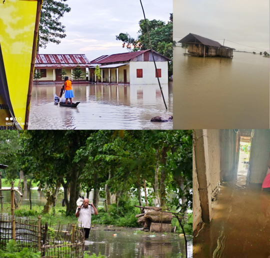
“Majuli flood situation”. Photo Credits: “NEEDS, Jorhat”
Government and NGOs initiatives steps during flood:
During the Assam floods, the government and non-governmental organisations (NGOs) took steps to save people. When the floods hit Assam, the NDRF (National Disaster Response Force) and SDRF (State Disaster Response Force), as well as the Army, acted quickly to rescue people and conduct other activities. The Central Government and State Governments provide basic commodities and hospital facilities to flood victims. NGOs, on the other hand, provide basic necessities to flood victims.
In 2011, Assam became the first state in the country to issue a satellite-based flood hazard atlas, and it was also the first to update the atlas in 2016. Moreover, the World Meteorological Organization launched the South Asia Flash Flood Guidance System (South Asia FFGS) on October 23, 2020, in response to the yearly monsoon-related disaster. Through forecasts and early warnings of threats associated with flash floods, the system will increase disaster risk reduction and preparedness across Bangladesh, Bhutan, India, Nepal, and Sri Lanka, with the goal of reducing the loss of life and property damage.
THE SOLUTIONS:
Today there are various startups that are helping to reduce and prevent the damaging effects of floodwaters. Thus, let’s look into some who can maybe help in reducing the effect of the Assam flood.
Flood-Con: A startup based in the US developed a control structure that simulates pre-developed hydrology during a real-time storm. The startup uses fixed opening control structures, reservoir routing, and hypothetical storm modelling to replace traditional flood management.
FloodMapp: An Australian company that created DASH which combines big data analytics, automation, and machine learning techniques with novel hydrology and hydraulic models. DASH also ingests LIDAR datasets in real-time to produce hyper-granular flood inundation extents and depth rasters.
Bufferblock: A Dutch startup, makes its eponymous water management solution for urban stormwater drainage and buffering. Their solution allows for a shallower installation and higher buffering capacities, resulting in a more cost-effective solution and is also capable of withstanding heavy traffic and has a water storage capacity of 266 - 532 litres per square metre.
StormHarvester: A British startup that automates drainage infrastructure monitoring and control. They predict overflows by combining civil infrastructures such as valves, pumps, and floodgates with machine learning-based algorithms. The system then operates the relevant parts of the network automatically to reduce spillages. This solution also allows for better utilisation of the network's available water storage.
AquiPor: A startup based in the US, developed permeable hard surface materials with the strength and durability of concrete. The material functions are similar to those of a hard surface filter, allowing it to sift out harmful pollutants and particulates that can cause problems in stormwater. Furthermore, this material filters stormwater without becoming clogged by dirt or debris. Later, stormwater percolates through the material and subgrade, eventually returning to the ground below naturally. The material can handle up to 25 inches of water per hour, which helps to prevent large-scale runoff.
Tenevia: To reduce the risk of flooding, Tenevia uses image sensors to monitor water levels. Its system uses digital surveillance cameras to monitor water levels, surface speed, and flow along rivers. The cameras are not below the waterline, unlike more traditional monitoring systems such as water gauges. This allows users to track and collect data during flood events when there is little concrete information available at the time when it is most needed.
Eleaf: They provide services and tools that are based on satellite data for agriculture, water management and crop index insurance.
When we look into a wider perspective, at various levels, from smallholder farmers to multinational organisations, several approaches and technologies could be used to mitigate the effects of flood with the help of government initiatives. Along with risk assessment and emergency planning, similar technologies such as flood proofing, wet and dry flood forecasting, and flood insurance, might significantly lessen the impact of floods on smallholder farmers and agriculture. These approaches can bring the development of the state to a greater level and will enhance the country’s economy with full potential.
About Global Launch Base:
The Indian Agri-Tech industry is expected to grow exponentially to over $30 Billion by 2025. Global Launch Base specializes in bringing high tech innovation for Agri-Tech and Conservation into the Indian Market.
Our expertise includes working with high tech European Agri-Tech companies and working with the local farmers and actually managing our own farms!. We look forward to helping you navigate the vastly different but vibrant Indian Agricultural markets.
Agri-Tech Innovations
Forest/ Wildlife Conservation
Food Waste Reduction
Written by: Gargi Sarma
Key Contributors: Anubha Chicki and Kiran Gange
#hashtag#asaam hashtag#assamfloods hashtag#innovation hashtag#people hashtag#technology hashtag#startups hashtag#help
0 notes
Photo

Dibrugarh,Asaam💜❤️ Ghumo Ghumaao.. FOLLOW @ghumoghumaao ✔ & Use Hashtag #ghumoghumaao ✔ video credit :Unknown Follow our community @ghumoghumaao . . . . . . . #northeast_india #aerialphotography #picoftheday #photographers_of_india #photooftheday #Beautiful #beautifulplaces #heavenonearth #meadows #gogreen #pahalgam #travelrealindia #TravelDiaries #Travelphotography #_soi #portraitphotography #storiesofindia #wanderlust #incredibleindia #gypsysoul #northeastindia #landscapes #bestoftheday #landscapephotography #nikonphotography #Mountains #MyPixelDiary #mountainlife #oneplusphotography (at Dibrugarh, Assam) https://www.instagram.com/p/B4kCyS4nZCO/?igshid=68enjuq90dr9
#ghumoghumaao#northeast_india#aerialphotography#picoftheday#photographers_of_india#photooftheday#beautiful#beautifulplaces#heavenonearth#meadows#gogreen#pahalgam#travelrealindia#traveldiaries#travelphotography#_soi#portraitphotography#storiesofindia#wanderlust#incredibleindia#gypsysoul#northeastindia#landscapes#bestoftheday#landscapephotography#nikonphotography#mountains#mypixeldiary#mountainlife#oneplusphotography
0 notes
Last Seen Blogs

isisrisesmec
Isisrises, the lady spy

stellaforsen-blog
Stella Forsén

charliedms
Charlie Damasio

topteny
Online Lifestyle Magazine

tsouuu
女婴