#mundik
Text

Judge Holden by Rob Wood (2021)
“The judge is clearly no ordinary mortal, but at times it is suggested that he is more of a god than a demon. Sitting half-naked in front of the fire, the judge is described as a "great pale deity" (92). Later, the judge appears as a statue of some godlike being or idol. His eyes, like a sculpture's, are "empty slots" (147). Sitting on the ground with "his hands rested palm down upon his knees," the judge seems to be engaged in deep meditation 147). Rick Wallach argues that here the judge " incarnates the attributes of an oriental deity." Specifically, "the judge's poses suggest Shiva," whose "visage, like Holden's, is always serene amid the carnage he engenders" (128-29). The men seated around the judge grow wary of this meditative state, "so like an icon was he in his sitting that they grew cautious and spoke with circumspection among themselves as if they would not waken something that had better been left sleeping" (147). The implication is that the men grow fearful in the judge's presence, because they sense something otherworldly and malevolent.
The judge is situated somewhere between the demonic and the godlike, a position that corresponds to the Gnostic view of the god of this world. As Hans Jonas explains, the Gnostics believed that demons known as archons "collectively rule over the world" and "are also creators of the world, except where this role is reserved for their leader, who then has the name of demiurge" and "is often painted with the distorted features of the Old Testament God" (43-44). The human spirit is "a portion of the divine substance from beyond which has fallen into the world; and the archons created man for the express purpose of keeping it captive there" (44). The demiurge and his archons conceal the existence of the divine source, or the alien God, in order to keep human beings imprisoned in the cosmos. Thus Gnostic theology identifies the biblical God, Yahweh, as a demon, responsible not only for the creation of the world but also for the obscuration of divine Reality. By conflating the creator God and the devil into one entity, Gnostic theology creates a new kind of deity, whose simultaneously demonic and godlike characteristics are reflected in the multifaceted enigma that is Judge Holden.
In "Gravers False and True: Blood Meridian as Gnostic Tragedy," Leo Daugherty argues that "gnostic thought is central to Cormac McCarthy's Blood Meridian" (159) and perceptively identifies the judge as one of the Gnostic archons, or perhaps even the demiurge himself. Daugherty writes that like the "archons, Holden also possesses all the other characteristics of Yahweh as the Gnostics saw him: he is jealous, he is vengeful, he is wrathful, he is powerful and - most centrally - he possesses, and is possessed by, a will" (163). The "Earth is the judge's" (164), writes Daugherty, and, indeed, the judge is described as seeming "much satisfied with the world, as if his counsel had been sought at its creation" (140). Christopher Douglas draws attention to McCarthy's use of "as if," arguing that it "marks the failure of traditional realist language to evoke the larger theological design behind the events of the novel and the impossibility of linguistically imagining the design that McCarthy suspects must lurk behind the amoral nothingness of the world" (13). Thus, far from dismissing the judge's participation in the creation of the world as a hypothetical fantasy, McCarthy's "as if" actually gestures toward the ineffable and unutterable reality of this vision.
Sitting in a saloon, the judge is depicted "among every kind of man, herder and bullwhacker and drover and freighter and miner and hunter and soldier and pedlar and gambler and drifter and drunkard and thief," but though he "sat by them," he remained "alone as if he were some other sort of man entire" (325). Once again, we may apply Douglas's reading to McCarthy's characteristic usage of "as if," identifying it as a linguistic marker pointing to a "larger theological design" rather than a simple exercise in hypothetical rhetoric. Although the judge seems perfectly at home in the crazed, blood-soaked world of Blood Meridian, it is continually suggested that he is somehow not of this world. This is yet another of the judge's paradoxical attributes that can be resolved in the light of Gnostic thought. Gnostic texts often refer to the world as the "inn" in order to emphasize the concept that the pneuma lives in temporary exile from its true home. The archons can be thought of as "the 'fellow-dwellers of the inn' though their relation to it is not that of guests" (Jonas 56). Hence, just as the archons inhabit the realm of the manifest world without being human, the judge walks among men while being no ordinary mortal. Furthermore, the judge's existence is not limited to the so-called Wild West of the 1850s, for he was also "among the dregs of the earth in beggary a thousand years and he was among the scapegrace scions of eastern dynasties" (325). This suggests that the judge cannot be limited by time, place, or social hierarchy; his existence stretches back to distant times, distant lands, and infiltrates all levels of human society, from beggar to king.
Most disturbingly, the judge seems to possess no beginning and no end. In a fit of ether-induced delirium, the kid experiences a revelation regarding the judge's mysterious lack of origins: "Whoever would seek out his history through what unravelling of loins and ledgerbooks must stand at last darkened and dumb at the shore of a void without terminus or origin and whatever science he might bring to bear upon the dusty primal matter blowing down out of the millennia will discover no trace of any ultimate atavistic egg by which to reckon his commencing" (310). The kid's vision reveals that the origin of the judge cannot be uncovered through genealogy, nor scientific enquiry; any attempt to do so will only lead one back to the primordial void, the chaos that precedes the existence of the cosmos in the creation myths of countless traditions. Similarly, the judge has no final destination; in the final paragraph of the novel he is dancing an eternal dance, reminiscent of Shiva's cosmic dance of destruction: "He never sleeps, the judge. He is dancing, dancing. He says that he will never die" (335). Ordinary sleep is a minor prelude to the great sleep of death and the immortal judge is eternally wakeful.
Harold Bloom comments on the judge's lack of origins in How to Read and Why, but he curiously argues against a Gnostic interpretation of the passage. Despite the fact that Bloom identifies McCarthy as a Gnostic - "Faulkner is a kind of unknowing Gnostic; West, Pynchon, and McCarthy in their different ways are very knowing indeed" (237) - and is prepared to admit that "McCarthy gives Judge Holden the powers and purposes of the bad angels or demiurges [sic] that the Gnostics called archons," he inexplicably goes on to insist that McCarthy is actually telling "us not to make such an identification," because "any 'system,' including the Gnostic one, will not divide the Judge back into his origins. The ultimate atavistic egg' will not be found" (Modern Critical Views 4). I agree with Bloom's assertion up to a point, namely that the supernatural nature of the judge is such that he surpasses the limitations of the human mind and thus cannot be limited to any one system of thought. Nevertheless, certain aspects of the judge's nature may be illuminated by references to the various spiritual and philosophical traditions that have attempted to address the problem of evil. This is the line of argument adopted by Steven Frye, who argues that the judge's purported lack of origins should not discourage us from interpreting the literary figure in the context of various systems and traditions, including, but not limited to, "Judeo-Christian cosmology and typology, scientific materialism with its often purely atheist implications, the continental philosophy of Friedrich Nietzsche, philosophical nihilism, and the fascinating conceptions of ancient Gnosticism." Frye argues that Judge Holden "is by no means a patchwork creation of competing philosophical configurations, but a distinctive artistic embodiment of darkness that stands apart but nevertheless draws on these various perspectives" (Understanding Cormac McCarthy 79). He adds that "it is perhaps more fruitful to consider that various notions of evil, literary or philosophical, partially illuminate rather than define his nature" (91). I would argue that although Gnosticism is not the definitive system through which one may arrive at an understanding of the judge, it is nevertheless a particularly useful one due to its preoccupation with the evil manifest in creation.
Furthermore, McCarthy subtly alludes to the judge's connection with Gnostic archons in his esoteric subheading to chapter 15, "The Ogdoad" (204). The heading refers to a scene in which the Glanton gang stumbles upon eight decapitated heads arranged in a circle. "The heads were eight in number . . . and they formed a ring all facing outwards. Glanton and the judge circled them and the judge halted and stepped down and pushed over one of the heads with his boot" (220). According to A Dictionary of Gnosticism, the ogdoad (Greek for "group of eight") is the "eighth sphere, above the seven planetary spheres" and "may be considered to be the sphere of the fixed stars, but may also be associated with the home of Sophia [the Gnostic personification of wisdom], or the demiurge, or in simpler cosmologies the home of the true God" (A. Smith 177). According to these "simpler" Gnostic cosmologies, the cosmos is ruled by seven archons, whose kingdoms are hierarchically arranged in concentric circles around the manifest world.In what is known as the "Ascent of the Soul" - a teaching common to both Hermeticism and Gnosticism - the souls of the dead must pass through the hebdomad (Greek for "group of seven"). During this process "all passions and vices are given back to the various spheres from which they were derived in the soul's original descent." Afterward, the "essential man' proceeds to the Ogdoad (Eighth) where he praises the Father with those who are there" (Pearson 279). In other words, the perfected spirit ascends to the "eighth realm," thereby returning to its divine source. By knocking over the eighth head, the judge reduces the ogdoad of the alien God to the hebdomad of the archons. If one considers the ogdoad to be the realm of the alien God, then the judge's action is symbolic of his denying transcendence to those who would seek to escape from the manifest world through spiritual development.
The very title of "the judge" carries connotations of biblical judgement, a concept that strengthens his resemblance to the demiurge and the archons. Harold Bloom writes that Judge Holden "seems to judge the entire earth" and the name Holden "suggests a holding, presumably of sway over all he encounters" (Modern Critical Views 4). The judge seems to be obsessed with bringing every animate and inanimate thing in creation under his jurisdiction. When asked why he shoots and stuffs birds, catches butterflies, presses leaves and plants between the pages of his ledger book, and sketches artifacts - often destroying the originals after their image has been recorded - the judge replies, "Whatever in creation exists without my knowledge exists without my consent" (198). This statement would be absurd if uttered by a mortal man, but chilling if uttered by an archon bent on keeping all things imprisoned in the fetters of manifest existence.
This reading also illuminates the judge's desire to have "the existence of each last entity . . . routed out and made to stand naked before him," so he might be "suzerain of the earth." When asked what a suzerain is, the judge replies, "He is a special kind of keeper," one who "rules even where there are other rulers," because his "authority countermands local judgements" (198). Once again, the judge's emphasis on judgment links him significantly to a Gnostic portrayal of Yahweh. Similarly, his insistence that he be the supreme ruler recalls Yahweh's commandment: "Thou shalt have none other gods before me. . . . Thou shalt not bow down thyself unto them, nor serve them: for I the LORD thy God am a jealous God" (Deuteronomy 5:7, 9). As the Gnostics were quick to point out, Yahweh is actually unwittingly revealing the existence of another god, "For if there were no other one, of whom would he be jealous?" (qtd. in Pearson 66). Like Yahweh, the judge's insistence on being the sole ruler subtly suggests the existence of other "principalities," "powers," and "rulers of the darkness of this world" (Ephesians 6:12) with which he competes for supremacy.”
Most telling of all, however, are pronouncements the judge makes with his hands placed on the ground: "This is my claim, he said. And yet everywhere upon it are pockets of autonomous life. Autonomous. In order for it to be mine nothing must be permitted to occur upon it save by my dispensation" (199). Robert Jarrett explains that "dispensation . . . is a key term in evangelical Protestant theology, referring to the different covenants regulating the relations between Jehovah and man" (Cormac McCarthy 78). It is by such a "dispensation" that a "terrible covenant" (126) was formed between the mortal Glanton and the sinister, Yahweh-like Holden. Leo Daugherty also links this passage to Yahweh, arguing that "Judge Holden's power is not yet complete, since his will is not yet fulfilled in its passion for total domination" and that "this was also necessarily true of the Gnostic archons, just as it was true of the Old Testament Yahweh" (163). According to Gnostic thought, the demiurge and his archons must exercise their tyrannical rule in order to prevent the trapped fragments of the divine from returning to their source, for if all divine fragments were liberated, there would be nothing left to animate the dead matter of the cosmos. As Kurt Rudolph explains, "the powers which rule the world, the Archons . . . try to impede the [spirit's] return in order to prevent the perfecting of the world of light and thus protract the world process" (172). The archons are powerless in exerting their dominion over those who possess gnosis, or what the judge calls "pockets of autonomous life." Thus the judge knows that he will never be suzerain of the cosmos unless he can keep every living thing imprisoned in the manifest realm.” - Petra Mundik, ‘A Bloody and Barbarous God: The Metaphysics of Cormac McCarthy’ (2016) [p. 35 - 40]

“Satan, avenging angel, albino monstrosity, or hyperrealist of paradise lost, the judge remains the most morbidly captivating character in Blood Meridian. He is reminder alone that the American west was at times a holocaust of Manifest Destiny and white supremacy, the devil's genocidal shibboleths.” - Kenneth Lincoln, ‘Cormac McCarthy: American Canticles’ (2010) [p. 87]
#mccarthy#cormac mccarthy#blood meridian#judge holden#bloody and barbarous god#mundik#petra mundik#gnosticism#harold bloom#metaphysics#shiva#demiurge#archon#satan#devil#kenneth lincoln#canticles#manifest destiny#shibboleth
55 notes
·
View notes
Quote
"The most startling solar imagery, however, consists of the following: 'The top of the sun rose out of nothing like the head of a great red phallus until it cleared the unseen rim and sat squat and pulsing and malevolent behind them' (44-45). In Blood Meridian, McCarthy inverts the traditional, life-giving symbolism of the sun- hence the image of the phallus and all the subsequent connotations of procreation- and turns it into a symbol of cosmic malevolence."
A Bloody and Barbarous God: The Metaphysics of Cormac McCarthy, Petra Mundik
1 note
·
View note
Text
A Bloody and Barbarous God: The Metaphysics of Cormac Mccarthy
A Bloody and Barbarous God: The Metaphysics of Cormac Mccarthy
A Bloody and Barbarous God: The Metaphysics of Cormac Mccarthy Petra Mundik
A Bloody and Barbarous God investigates the relationship between gnosticism, a system of thought that argues that the cosmos is evil and that the human spirit must strive for liberation from manifest existence, and the perennial philosophy, a study of the highest common factor in all esoteric religions, and how these…

View On WordPress
0 notes
Photo

“Berenang ke mundik ikan haruan, Mundik jauh hingga seberang, Banyak bunga di taman Tuan, BungMas juga dipuna orang.” Ewahh! . . Sekadar info buat semua, saya Zareen Naqiyah, merupakan Master Dealer Aktif Public Gold bawah mentorship Tn. Mohd Zulkifli Shafie (Penulis Buku Wang Emas dan Misi Bebas Hutang) dan berpengalaman membimbing lebih 600 penyimpan emas seluruh Malaysia serta sedikit di Indonesia, Singapura, Arab Saudi, Jepun dan lain-lain lagi. Sahabat yang ingin saya bimbing sampai bijak emas, boleh hubungi saya melalui Whatsapp +60135245899 atau klik link di bio untuk respons lebih cepat. Zareen Naqiyah Zool Ambia Master Dealer Aktif Public Gold (PG00131385) www.zareennaqiyah.com #PublicGoldNegeriSembilan #DealerPublicGold #PublicGoldJohor #PublicGoldPenang #PublicGoldTerengganu #PublicGoldSabah #PublicGoldSelangor #PublicGoldIndonesia #DinarEmas #JongkongEmas #Goldbar #Maskahwin #Barangkemas916 #Emas916 #Emas999 #Emas24Karat #Emas22Karat #EmasMurah #EmasPatuhSyariah #SimpanEmas #BisnesEmas #PelaburanEmas #AkaunEmas #BukuWangEmas #PelaburanPatuhSyariah #KutuEmas #MalaysiaTrending #MalaysiaIgers #PGG100Network https://www.instagram.com/p/CYgUMxuFPkV/?utm_medium=tumblr
#publicgoldnegerisembilan#dealerpublicgold#publicgoldjohor#publicgoldpenang#publicgoldterengganu#publicgoldsabah#publicgoldselangor#publicgoldindonesia#dinaremas#jongkongemas#goldbar#maskahwin#barangkemas916#emas916#emas999#emas24karat#emas22karat#emasmurah#emaspatuhsyariah#simpanemas#bisnesemas#pelaburanemas#akaunemas#bukuwangemas#pelaburanpatuhsyariah#kutuemas#malaysiatrending#malaysiaigers#pgg100network
0 notes
Text
New Post has been published on Trekking in Pakistan
New Post has been published on http://bit.ly/2slcObP
K7 Base Camp
Duration 5 days Distance 57.6km Standard moderate Season Mid-June-September Start/Finish Hushe Zone and Permit restricted, US$50 permit Public Transport yes Summary The Tsarak Tsa Valley, the route to k7 Base Camp, is a tantalising trek for admirers and climbers of big rock walls alike.
K7 (6934m), first climbed in 1984 by a Japanese expedition, and Link Sar (7041m) form a ridge north-east of the upper Tsarak Tsa Glacier. K7’s granite face is one of the world’s largest. K6 (7281m) is on the ridge south of the upper glacier. The area between Spangser and K7 Base Camp is a climber’s paradise, with several 5000m peaks and tons of unclimbed granite.
PLANNING
Maps
The Swiss Foundation for Alpine Research 1:250,000 orographical map Karakoram (sheet 2) covers the trek. Tsarak Tsa is the Balti name for the glacier that is incorrectly labeled as Charakusa. Spangser is labeled as Supanset and Tikchumik as Techimic.
Permits and Regulations
This trek is in a restricted zone where a permit and licensed guide are requires (see Trekking Permits,).
Stages
It is eight stages total round trip from Hushe: (1) Shaishcho; (2) Tikchumik; (3) Spangser; (4) K7 Base Camp; and (5-8) four stages to return via the same route.
GETTING TO/FROM THE TREK
See Hushe (p).
THE TREK
Day 1 : Hushe to Shaishcho
4 hours, 9.3km, 280m ascent
See Day 1 of the Gondogoro Valley trek (p) for directions.
Day 2 : Shaishcho to Spangser
4 hours, 8.5km, 670m ascent
Head east from Shaishcho into the ablation valley north of the Tsarak Tsa Glacier. The sharp spires of K7 and Link Sar are visible ahead. Tikchumik (small spring), which is in the ablation valley at the base of the ridge west of the Chogolisa Glacier, has good water. Continue along the base of the ridge to the Chogolisa Glacier’s west margin. Cross this glacier to the green and flowered Spangser above the confluence of the Chogolisa and Tsarak Tsa glaciers. Spangser (4000m) is the highest pasture and is used mid-July to mid-August. Granite slabs rise above Spangser (in Balti spang means ‘meadows’; ser, a ‘place to walk about’) and Namika (6325m) towers across the Tsarak Tsa Glacier.
Day 3 : Spangser to K7 Base Camp
4 hours, 11km, 600m ascent
Continue through the ablation valley north of the Tsarak Tsa Glacier, at times over difficult terrain, to K7 Base Camp (4600m).
Days 4-5 : K7 Base Camp to Hushe
2 days, 28.8km, 1550m descent
Follow the trail to Hushe, camping at Shaishcho on Day 4.
Other Treks
The following treks are all in an open zone, except where noted below.
NORTH-WEST BALTISTAN
To the west and south of the Basha Valley are the infrequently visited Tormik and Stak valleys. Their rarely crossed passes make for unspoiled and adventurous trekking. Only basic supplies are available in villagers, so bring everything you need. Bagicha and Dassu (1½ hours from Skardu), Stak (three hours from Skardu) and Sassi (1½ hours from Gilgit) are trailheads along the Gilgit-Skardu road. It’s easy to get on or off any daily transport between Skardu and Gilgit at any of these places.
Ganto La
Ganto La (4606m) is a pass, usually open late June to early September, linking the Basha and Tormik valleys. It’s an interesting, but steep, exit from the Basha Valley. The moderate trek starts from Hemasil in the Basha Valley, just across a stream north of Chu Tron, which means hot springs in Balti. This excellent hot spring, perfect for a pre-or post-trek soak, is around 39°C, has almost no sulphur smell, and gushes forth in a large flow. The villagers have constructed several enclosed bathhouses with doors, open ceilings and cement, walled, knee-deep pools.
It takes two or three days to cross the Ganto La to Harimal in the Tormik Valley from where you can head south to reach Dassu or Bagicha on the Gilgit-Skardu road in one easy day, or head north-west and cross Stak La. From Hemasil, ascend steeply 1000m to the ridge above Chu Tron. Camp in a meadow near huts at Matunturu. The next day, continue steeply to the Ganto La, with a permanent steep snowfield below the pass. Descend steeply to a pleasant meadow camp site called Pakora. Harimal is a short day’s walk farther.
Stak La
Stak La (4500m) links the rugged alpine Stak Nala to the green upper Tormik Valley, both of which have trailheads on the Gilgit-Skardu road. The demanding technical trek makes a four- to five-day loop and can be combined with the Ganto La trek (above). From Dassu, head north up the Tormik Valley. At Harimal (not shown on the Swiss map), the route over the Ganto La branches to the north-east. Continue up the Tormik Valley to Dunsa and Camp near the polo field by herders’ huts. At the valley’s head cross a small glacier and reach the Stak La. The west side of the pass is corniced, so bring a rope and ice axe. Descend the glacier about 500m to a grassy camp site near a large boulder. The view of Haramosh and its large eastern glacier, Khotia Lungma, is stunning. Follow the river’s true left bank as it bends south 20km to Stak Village. It’s possible to get a jeep (Rs 25) between Stak and the Gilgit-Skardu road, 1km east of the bridge over Stak Nala. Transport in a wagon along the Gilgit-Skardu road to either Gilgit or Skardu costs Rs 70, whereas a special hire costs Rs 2000.
HARAMOSH LA
Haramosh La (4800m) is a glaciated pass linking the Chogo Lungma and Haramosh glaciers on its north-east side with the Haramosh Valley to its west (see the Chogo Lungma Glacier map, p307). The pass is enclosed by Laila (6986m), which towers over the confluence of these glaciers, Mani (6685m) and Haramosh (7409m). This extreme nine-day technical trek, which is possible late to July to early September, crosses one of the Karakoram’s most formidable and infrequently done passes. Snow and avalanche danger are present on both side of the pass early in the season with rock fall becoming more of a danger by mid-Summer. This trek is only suited to experienced trekkers with mountaineering experience. The Haramosh La is usually crossed from east to west.
From Doko in the Basha Valley, the route follows the Chogo Lungma Glacier (see p) for the first 3½ days as far as Bolocho. From Bolocho, the route crosses the Chogo Lungma Glacier, heads south and west up the heavily crevassed Haramosh Glacier, and reaches a grassy ablation valley along the glacier’s north margin and Laila Base Camp (4100m) on Day 5.
On Day 6, rope up to reach Sharing, the level glacial basin at the base of the pass, five to six hours from Laila Base Camp. On Day 7, travel in roped teams about four hours to the pass, probing carefully for frequent crevasses. Keep to the glacier’s west side where it’s less steep and fix a rope at the steepest section near the top. Camp on top of the level, open Haramosh La. Stronger parties may prefer to combine Days 6 and 7 by leaving Laila Base Camp before dawn to ascend Haramosh La the same day, reaching the top by mid-morning.
Depending on snow conditions, you may need to fix as much as 500m of rope to descend the steep, scary snow slope on the west side of the pass on Day 8. Beware of avalanche and rock-fall danger as you descend steep scree lower down. Mani, at the bottom, is a possible camp site, but a little farther is the inviting Kutwal Lake (3260m), seven to eight hours from the pass.
Continue downvalley on a good trail on Day 9 to Dassu with views of high peaks all around. When you prearrange a vehicle, it can meet you at the roadhead in Dassu. Otherwise, walk on the road along the Phuparash River to Sassi on the Gilgit-Skardu road to catch a ride on a passing vehicle.
To attempt to cross the Haramosh La without a qualified companion who knows the route and its danger is foolhardy. Conflict between Arandu’s Balti people and Haramosh’s Shina-speakers, however, reportedly prevents Arandu porters from crossing the pass, so be sure to hire a competent Shina speaker. Local porters know the route, but don’t know where or how to fix ropes, judge avalanche or rock-fall danger, or make crevasse rescues if necessary. Wearing a climbing helmet is prudent.
It’s 14 stages total from Doko: (1) Arandu; (2) Churzing; (3) Chogo Brangsa; (4) Kurumal; (5) Bolocho; (6) Laila Base Camp; (7) Sharing; (8) Haramosh La; (9) Mani; (10) Kutwal Lake; (11) Kutwal; (12) Iskere; (13) Dassu; and (14) Sassi.
DEOSAI
Numerous little-Known routes cross the Deosai Mountains between the Indus River west of Skardu and the Astor Valley. Three valleys along the Indus River’s south bank, Shigarthang, Basho and Skoyo, have wildlife conservation programs where the likelihood of seeing wildlife is high. Trekkers can help support these initiatives by visiting them. Dambudas and Bagicha villages, marked by signs along the Gilgit-Skardu road, are where public transport drops you off. Neither village, however, is marked on maps.
Deosai Traverse
Some trekkers simply walk along the 165km-long jeep road between Skardu and Astor across the Deosai Plains in an easy four or five days (see the Burji La map,). From Skardu, the road heads south up the Satpara Valley, passing Satpara Lake and village. The road continues west across the Deosai plateau, crossing large clear streams via bridges. As it leaves the Deosai, it skirts the north shore of charming Sheoshar Lake, then crosses Sheoshar Pass (4266m, marked Chhachor Pass on the U502 Mundik (NI 43-3) map) into the Chilam Gah, which becomes the Das Khirim Gah as it descends to meet the upper Astor Valley. You can cut the walk shorter by organizing a Skardu-Satpara special hire for Rs 300 at the start or by getting on a NATCO bus (Rs 60, five hours) at Chilam for the daily trip to Astor village.
Nanga Parbat is visible in the distance from Deosai hilltops, but a fun two-day side trip offers never-to-be-forgotten views of Nanga Parbat. When heading north-west down the Das Khirim Gah, cross a bridge below Gudai to reach Zail. Follow a trail to the pastures above, and ascend the dry ridge to camp the first night where the entire massif stretches before you. The next day continue down the rugged Bulashbar Gah to meet the Astor Valley at its confluence with the Rupal Gah.
Alampi La and Banak La
A demanding six-day trek across either the Alampi La or Banak La, best crossed mid-June to September, links the Shigarthang and Astor Valleys. Alampi La, also used as a route between Srinagar and Skardu, was probably first crossed by Vigne in 1834-35. Banak La is a more direct and difficult route. The Shigarthang Lungma joins the Indus Valley near Kachura Lake and village (marked Katzarah on the U502 Mundik (NI 43-3) map), 30km west of Skardu on the Gilgit-Skardu road. Skardu-Kachura special hires cost as much as Rs 350 and ones to the road’s end at Tsok cost Rs 700. Head south-west up the Shigarthang Lungma to Shigarthang village, whose residents are Brok-pa Shina speakers. Continue west upvalley 10km to huts at Thlashing Spang where the valley divides: the west branch leads to Banak La and the south-west branch leads to Alampi La.
To Alampi La (5030m), continue up the rocky Shigarthang Lungma and camp below the pass. The ascent to the pass is over snow. The descent, initially more than 35 degrees, is extremely steep and rocky. Continue more gently to a meadow camp (4000m) in the basin below the pass. Continue 5km west down this side valley into Bubind Gah, which joins the Das Khirim Gah and the Deosai road at Gudai, two days from the meadow camp. From Gudai, a side trip offers more Nanga Parbat views (see Deosai Traverse, left).
To Banak La (4963m), follow a steep, rocky path along the stream west-north and camp above the tree line at Urdukas (3962m), 6km from Thlashing Spang. Continue up across a glacier to the pass, 6km from Urdukas. Crevasses on the glacier are covered by snow bridges until late summer, but use a rope for safety. Descend steeply 8km to Chumik (3657m) and the Urdung Gah. Continue downvalley in two days to Astor.
Dari La
A demanding three-day trek over the Dari La (4724m) links the Shigarthang Lungma with the Deosai Plains. From Shigarthang village, head east then south-east on Day 1 up the Dari Lungma and camp at the lush Dokhsun pasture below the pass. On Day 2, cross Dari La, and descend to Usar Mar at the confluence of the Burji Lungma. On Day 3, walk south the road at Ali Malik Mar and ride in a jeep back to Skardu via the Satpara Valley. Alternatively, continue north from Usar Mar and trek over the Burji La (see p), making it a five-day trek.
Naqpo Namsul La
A demanding five-day near loop trek crosses the glaciated Naqpo Namsul La (5000m), a pass near the Basho Valley’s head. The Basho Valley, whose name means ‘grape’ for the valley’s vine-yards, meets the Indus River 36km west of Skardu and 16km south of Bagicha. The Basho River provides hydroelectric power for Basho, Skoyo and Rondu. Basho village (Basha on maps) is linked with the Gilgit-Skardu road via a bridge over the Indus River. Skardu-Basho special hires cost Rs 800. The jeep road goes another 9km up the broad valley to Sultanabad, where the residents are Brok-pa Shina speakers. Skardu- Sultanabad special hires cost Rs 2500.
From Sultanabad (Turmik on the U502 Mundik (NI 43-3) map), the trek heads south-west upvalley. It then crosses the pass into the upper Shigarthang Lungma, and descends to Kachura along the Gilgit-Skardu road. Alternatively from the upper Shigarthang Lungma, it’s possible to cross Banak La (see Alampi La and Banak La,).
Skoyo
Skoyo village, about 60km west of Skardu, is linked to the Gilgit-Skardu road via a bridge over the Indus River (under construction at the time of research). Skoyo is 4km east of Dambudas and 8km west of Bagicha. Skardu-Skoyo special hires cost Rs 1000. Skoyo villagers have implemented the Project Snow Leopard to protect the Skoyo Valley’s snow leopard population, which is dependent upon income from trekking for support. An easy three-day loop trek visits pastures beneath the summit of Takti-i- Sulaiman (5632m). Contact the project’s Web site (w www. fmntrek king .com) for more information.
Trango Pir Pass and Harpo La
A very demanding four-day trek across either the Trango Pir Pass or Harpo La, two difficult glaciated passes, links the Tukchun Lungma to the Parishing Gah, an eastern tributary of the Astor River, and the Astor Valley. These passes are best done-mid-July to September. The trek starts from Shoat village on the Indus River’s true left (south) side, 4km west of the Dambudas and 2½ hours’ drive from Skardu. This area along the Indus River between Bagicha and Shoat, where it flows through a deep gorge called Rondu, was once a separate Kingdom. The palace of the former Raja of Rondu is in nearby Mendi. Bridges over the Indus connect both Shoat and Mendi with the Gilgit-Skardu road.
From Shoat, head south up the Tukchun Lungma, past Harpo village to Chutabar, where the valley divides: the south-west (right) branch leads to Trango Pir Pass; and the south-east (left) branch to Harpo La. Both routes have sizable markhor Populations.
To Trango Pir Pass (conflicting elevations range from 4800m to 5600m), leave the Tukchun Lungma at Chutabar and ascend the rough rocky valley. Camp below the pass near huts at Baltal. The next day, cross the pass, steep neat the top, and descend a glacier then a steep rocky spur to Thengi village in the Parishing Gah. Follow a road 10km downvalley to Astor.
To Harpo La (5115m), continue from Chutabar up the rough Tukchun Lungma 8km where the route to the pass turns south up a side stream. Continue up the side stream and camp below the pass. The ascent to the snow line is rocky. The pass is glaciated with significant avalanche danger. Descend the steep glacier on the north side below the snow line to camp. The next day continue 4km to the Urdung Gah and 10km to Thengi, and then to Astor.
Katichu La
Katichu La (4588m) is a pass linking Mehdiabad (formerly called Parkutta) on the Indus River east of Skardu to the Deosai Plains. The pass is usually snow-free July to late September and the moderate trek takes three days. Reportedly, a distant K2 is visible from the pass. When crossing from east to west, this trek is easily combined with the Burji La trek, or return to Skardu via the road down Satpara Valley. Get off the daily NATCO bus (Rs 45) or K-2 Travel Services wagon (Rs 60) between Skardu and Tolti/Kharmang at Mehdiabad, which depart Skardu at 1.30pm and 10am respectively.
SHIGAR AND BRALDU
Sosbun
A moderate five-day trek into the rarely visited Sosbun Valley offers wildlife-watching opportunities and, for climbers, ascents of unnamed walls and towers. Ride in a jeep from Skardu up the Braldu Valley to Chakpo (Chokpoing on the Swiss map) and camp. Trek up the Hoh Lungma to camp at Nangmah (Nangmoni Tapsa on the Swiss map). Cross the Sosbun Glacier to Jusma camp at the base of the spur between the Tsilbu and Sosbun glaciers. Trek up the Sosbun Glacier to Sosbun Base Camp at the base of the spur between the South and North Sosbun glaciers beneath Sosbun Brak (6413m). Return in two days to Chakpo.
Skoro La
Skoro La (5073m) is a little-used pass, first crossed by Falconer in 1838, linking Askole in the Braldu Valley to Namika and Shigar in the Shigar Valley (see the Baltoro Glacier map,). This pass was more frequently used before the road was completed up the Braldu Valley to Askole. It offers an alternative, demanding three-day trek between Askole and Shigar, useful when the road is blocked.
From Askole, cross the Braldu River on a footbridge and ascend steeply to Thal Brok, with fine views. Continue up the Skoro La Lungma’s west bank and camp at Darso Brok, a summer pasture at the Skoro La Glacier’s edge. The next day continue up the glacier, over snow three to four hours, then turn west and climb to the Skoro La. Descend 450m steeply over snow and rock to the steep grassy slopes below. Camp here or descend another 900m to the Skoro Lungma’s head to camp. The next day, follow the stream, crossing it continuously, with several steep sections, to Namika on the road in the Shigar Valley, 6.5km north of Shigar.
Panmah Glacier
The 42-km long Panmah Glacier forms the Dumordo River, which flows into the Biaho Lungma between Korophon and Jula (see the Baltoro Glacier map,). Askole villagers use summer pastures along this glacier. The Panmah is fed by two large glaciers, Choktoi to the north-west and Nobande Sobande to the north-east. The Choktoi leads to the base camp for the north face of the Latok spires. At its head is the difficult Sim La (5833m), which crosses Baintha Brak’s north shoulder. The entire area is in a restricted zone where a permit and licensed guide are required (see Trekking permit,). During the 1990s, experienced Westerners pioneered scenic and extreme technical treks here.
Treks begin from Thungol in the Braldu Valley. The approach follows the Dumordo River’s true left (east) bank, crosses to its true right bank below the Panmah Glacier’s snout, then continues along its east margin. Technical passes at the head of two eastern side glaciers, First Feriole and South Chiring, lead to the Trango and Baltoro glaciers. The First Feriole is reported to be the easier of the two. Continuing north up the Panmah Glacier, you cross the Chiring Glacier and reach the meadow of Skinmang (many ibex), a fine base for exploring the upper glaciers. The Nobande Sobande is reported to be mostly crevasse free with spectacular scenery. An unnamed pass just east of Biacherahi Tower enables parties to cross to the Choktoi Glacier and return to the Panmah Glacier in a five-day loop.
A longer near-loop trek is possible by crossing the Skam La (5407m) at the Nobande Sobande’s head, and following the Sim and Biafo glaciers back to Thungol. The east side of Skam La is reported to be straightforward, but the west side requires fixing as much as 300m of rope.
Conditions in this area can change in 1887 Younghusband found the Nobande Sobande inaccessible with ice blocks the size of house; in 1929 Ardito Desio found it remarkably smooth and was able to ski to its head; and the 1937 Shipton-Tilman expedition found it almost impassable, ‘broken by gaping crevasses and Tumbled masses of ice’. Technical trekkers must be prepared for the logistical challenges and changing conditions. Guides and porters don’t yet know these routes. If you hire someone make sure they’re adequately equipped for the rigours.
KHAPLU
From Khaplu’s, main bazaar, a 45 minute walk leads past the polo ground to the palace of the Raja of Khaplu, with its impressive four-storey wooden balcony above the entrance. A steep 20 minutes farther is Chakchun village, with an old mosque, and fine views across the Shyok River of Masherbrum at the Hushe Valley’s head.
Ghanche Tso
From the powerhouse at the upper end of the road, beyond the K-7 Hotel, it’s an easy seven- to eight- hour walk (two stages) up the Ghanche River to Ghanche Tso (lake).
Daholi Tso
From the polo ground, a jeep road climbs south-east to the summer settlements of Khaplutung and Hanjore, easy 1½ and 2½ hours’ walks, respectively, from the polo ground. The entire upper settled area, which is called Khaplu Brok, has great Masherbrum views. From Hanjore, a trail climbs behind the ridge in one long day (two stages) to Daholi Tso (lake).
Hushe
Honbrok
Picturesque Honbrok summer pastures high above the Hushe River west of Hushe village are easily visited on a day hike. It takes four hours to climb steeply to the pastures and 1½ to two hours to return to Hushe. Cross the Hushe River on the lower of the two footbridges to its true right bank. Walk up 15 to 30 minutes to Honbrok Nala. Cross it on a sturdy wooden footbridge. The trail ascends the stream’s true left (north) bank all the way to the pastures. Honbrok has reliable spring water. June to October is the best season. Honbrok is labeled Honboro on the Swiss map. Hushe-pa also refer to Honbrok Peak (6459m) as Cigarette Peak.
Aling Glacier
The Aling Glacier, the westernmost of Hushe Valley’s glaciers, is very large with multiple upper branches. Two summits above the upper glaciers, Mitre (5944m) and Sceptre (5800m), attract climbers. From Hushe, cross the river to its west bank and reach the footbridge over the Aling River in two hours. Across the footbridge, the trail turns west into the Aling Valley to Dumsum, a summer village with a two storey mosque. Continue west along the Aling River’s true left (north) bank to Shatonchen pastures, and along the Aling Glacier’s north margin to base camp and Drenmogyalba (royal bear), the highest pasture.
Hushe-pa have 14 stages (one-way) up the demanding route, but no one goes beyond the seventh stage. The seven one-way stages starting from Hushe are: (1) Dumsum; (2) Shatonchen: (3) Base Camp; (4) Drenmogyalba; (5) Sampibrangsa; (6) Khadanlumba; and (7) Tasa.
K6 Base Camp
K6 (7281m), also called Baltistan Peak, is usually approached from Kande village, midway up the Hushe Valley (see the K7 Base Camp map,). The steep granite walls that line the Nangmah Valley, including the Great Tower (5800m) south of the summer pastures, make this a popular rock-climbing destination.
From Kande, cross a footbridge over the Hushe River, then cross to the Nangmah River’s true right (north) bank and Mingyulu village (labeled Minjlu on the Swiss map). Continue up the river’s north bank to Nangmah summer pastures and on to K6 Base Camp along the Nangmah Glacier’s north-west margin. Kande’s K6 Hotel and Restaurant, above the road’s west side, is the place to hire porters. The moderate trek totals six stages: three stages from Kande to K6 Base Camp; and three stages to return via the same route.
KONDUS AND SALTORO
The beautiful Kondus and Saltoro valleys have been in a closed zone since the dispute between Pakistan and India over the Siachen Glacier began in 1984. These valleys were always the preferred approach route to the peaks along the giant Siachen. The southern approach to the Siachen, up the Nubra Valley, was impossible in summer due to high water and quicksand. Now, Kondus and Saltoro villagers no longer see expeditions and so lose the opportunity to earn much-needed income. These eastern Baltistan valleys have some of the finest clean granite towers in Baltistan, rivaling the Trango Towers for size and sheer vertically. Despite the closed status of the valleys, climbers have their eye in first ascents of big walls in these valleys, and the Pakistan government has shown signs of relaxing the restrictions. In the summer of 2000, a group of US rock climbers received a trekking permit for the Kondus Valley and made a first ascent of a 5000m tower just above Karmading village. Contact the Tourism Division (see Trekking Permits,) through a trekking company to request permission-it may say no, but it might say yes!
From Halde village in the lower Hushe Valley, across the river from Machulu, a jeep road follows the Saltoro River’s true right (north) bank through Tsino (Chino on the Swiss map) with its magnificent granite towers to Brakhor where the valleys divide: Kondus it to the north, and Saltoro to the east.
Kondus
The road up the Kondus Valley goes to Karmading, the highest village. A few hours’ moderate walk above Karmading to the north-east is the Khorkondus Valley and Khorkondus village. A waterfall tumbles over granite cliffs behind the village, and a small hot spring is 15 minutes north. The towers above Karmading can be approached without traversing a glacier. Above, the Sherpi Gang descends from Sherpi Kangri (7380m) and Saltoro Kangri (7742m). Above the pastures called Lisar (hunting ground) are clean granite walls, a climber’s delight. From Karmading, a trail leads up the main valley under the Karmading Wall several hours to the Kondus Glacier’s snout. It’s two stages to the highest pasture, Rahout Chen, passing through Byangeparo near the confluence of the Kaberi and Kondus glaciers en route. The Kondus Glacier is perhaps the Karakoram’s most difficult and chaotic glacier, but beautiful clean granite pinnacles rise above its upper reaches. From the Kaberi Glacier, some technical passes lead to Hushe’s Tsarak Tsa Valley.
Saltoro
From Brakhor in the Saltoro Valley, a bridge crosses to the river’s south bank. The road up the Saltoro Valley follows the south bank to Goma, the highest village. Women in the Saltoro Valley wear unique red- dyed raw wool hats with brown beaver-like tails. At Goma, the Bilafond, Gyang and Chulung streams meet, descending from the glaciers above. The Bilafond Glacier is also renowned for its granite towers. Beyond the passes above these glaciers are Indian troops.
0 notes
Text
Dari Blitar hingga Probolinggo
Hey!
Inilah cerita tentang pertemuan dan perpisahan yang akan memberikanmu banyak makna tentang tawa dan tangis
Berawal dari 25 Januari 2015 silam, ke suatu desa di pesisir Blitar. Kedatangan kami disambut dengan hujan deras dan petir yang menggelegar. Malam itu, ya, aku masih ingat. Malam itu, malam yang dingin, malam yang gelap tanpa cahaya lampu. Malam itu, listrik padam dan kami yang kedinginan disambut dengan hangat keramahan Bu Mundik dan Pak Mahsun.
21 Hari berlalu...
Saatnya kami pulang.
Hari itu adalah hari Minggu bersama senja kelabu
Air mata menghiasi perpisahan kami, 21 hari yang berlalu. Do’a dan Lambaikan tangan Bu Mundik dan Pak Mahsun melepas kami pulang.
Kembali berpetualang
17 Januari 2017 lalu, ke suatu desa di puncak Probolinggo.
Lagi, kedatangan kami disambut dengan hujan deras dan angin kencang. Malam itu, ya, aku masih ingat. Malam itu listrik pun padam (lagi). Dingin malam memeluk kami, dan keramahan Bu Fu’ah, Pak Muhammad, dan Pak Mistari menyambut kedatangan kami.
Kami pun memiliki sahabat berpetualang disana, ya, Mas Maulid namanya.
25 hari berlalu...
Saatnya kami pulang
Hari itu adalah hari Sabtu, mendung, listrik padam, dan kami pulang
“Budhe, kami pamit pulang”
Air mata pun berderai (lagi) menghiasi suatu perpisahan. Ada Bu Fu’ah, Pak Muhammad, dan Mas Maulid disana, mengantar kami pulang.
17 Februari 2017
Belum genap satu minggu setelah kedatanganku dari petualangan menakjubkan di Probolinggo. Kesempatan memanggil untuk berkunjung kembali ke Blitar.
Setelah 2 tahun berpisah,
Berpisah dengan air mata
dan Malam itu, kami bertemu kembali
dengan air mata
Di rumah yang sama, dengan penghuni yang sama sudah banyak yang berubah. Namun kenangan tetaplah sama.
Aku sangat bersyukur dan merasa sangat beruntung telah melakukan 2 perjalanan diatas. Bertemu dengan teman baru, hingga tinggal di rumah yang sama, melakukan suatu kebiasaan, hingga menjadi sebuah keluarga baru.
Mbak Lani, Mbak Icha, Denny, Yoga, Mas Harris, Mas Nanda, Dimas, Mbak Rike, Mbak Vita, Mbak Nuris, Dewi, Laila, Alya adalah nama-nama teman baruku, awalnya.
dan setelah kita hidup bersama selama 25 hari
mereka adalah keluarga, dan menjadi bagian dari perjalanan hidupku.
Bu Mundik, Pak Mahsun, Mbak Vivi, Mas Kholid, Bu Fu’ah, Pak Muhammad, Mas Maulid (beserta keluarga), Bu Suciati, Mas Didit, Mbak Um, Ainun, dan keluarga Pak Musa adalah keluarga baru yang aku dapatkan sepanjang petualangan ini, dengan keramahan dan kebaikan yang tidak akan pernah aku lupakan.
Aku mencintai duduk di tepi pantai pagi-pagi bersama botol bertutup pink milik mbak Lani yang berisi kopi hangat, Aku mencintai rapat di ruang tk bersama Mbak Lani, Mbak Icha, Denny dan Yoga, pun saat sarapan, makan siang, makan malam bersama mereka. Atau menghabiskan waktu siang dengan belajar bersama anak-anak jolosutro. Aku mencintai sore di Jolosutro menunggu cilok datang, dan menghabiskan cilok bersama-sama dengan anak-anak dan juga teman-teman.
Aku mencintai masak bersama dengan Mbak Vita, mbak Nuris, Mbak Rike, Dewi, Laila, Alya, Dimas (masak indomie), Mas Nanda (Goreng jemblem), dan mas harris yang menunggui kami memasak wkwkwk. Aku mencintai menghabiskan sore dan pagi di teras rumah Bu dhe. Aku mencintai menghabiskan kopi buatan Pak Muhammad, dan keripik singkong & Pisang goreng buatan ibu Mas Maulid. dan menghabiskan siang dengan belajar bersama anak-anak dusun kalimangu. Belajar sambil makan kerupuk pedas, dan jajanan micin.
Lagu-lagu itu menjadi nyata dan hidup bersama kenangan saat aku memainkannya Viva la Vida, The Days, Sahabat Kecil, This Feelin’
Inilah secuil Cerita tentang persahabatan dan kekeluargaan yang akan selalu kuceritakan kepada siapapun. Air mata menghantar perpisahan kami dan kembali air mata menyambut kedatangan kami. Banyak hal tentang kehidupan dan perjuangan dari cerita petualangan ini. Blitar dan Probolinggo adalah tempat yang mengajarkanku untuk menjadi The Person I’ve become
bijak berkata bahwa persahabatan yang erat tidak membutuhkan percakapan sehari-hari atau selalu bersama setiap saat. Selama hubungan persahabatan itu menetap di hati, maka teman sebenarnya tidak akan berpisah.
So, akan kututup cerita panjang ini dengan sebuah kata-kata dari tvc wonderful Indonesia
“What is it journey? We can’t stop revealiing the beauty that lies with them. Together”
Kemana lagi kita akan pergi?
0 notes
Text
New Post has been published on Trekking in Pakistan
New Post has been published on http://bit.ly/2uRr9eB
Other Treks in BALTISTAN

The following treks are all in an open zone, except where noted below.
NORTH-WEST BALTISTAN
To the west and south of the Basha Valley are the infrequently visited Tormik and Stak valleys. Their rarely crossed passes make for unspoiled and adventurous trekking. Only basic supplies are available in villagers, so bring everything you need. Bagicha and Dassu (1½ hours from Skardu), Stak (three hours from Skardu) and Sassi (1½ hours from Gilgit) are trailheads along the Gilgit-Skardu road. It’s easy to get on or off any daily transport between Skardu and Gilgit at any of these places.
Ganto La
Ganto La (4606m) is a pass, usually open late June to early September, linking the Basha and Tormik valleys. It’s an interesting, but steep, exit from the Basha Valley. The moderate trek starts from Hemasil in the Basha Valley, just across a stream north of Chu Tron, which means hot springs in Balti. This excellent hot spring, perfect for a pre-or post-trek soak, is around 39°C, has almost no sulphur smell, and gushes forth in a large flow. The villagers have constructed several enclosed bathhouses with doors, open ceilings and cement, walled, knee-deep pools.
It takes two or three days to cross the Ganto La to Harimal in the Tormik Valley from where you can head south to reach Dassu or Bagicha on the Gilgit-Skardu road in one easy day, or head north-west and cross Stak La. From Hemasil, ascend steeply 1000m to the ridge above Chu Tron. Camp in a meadow near huts at Matunturu. The next day, continue steeply to the Ganto La, with a permanent steep snowfield below the pass. Descend steeply to a pleasant meadow camp site called Pakora. Harimal is a short day’s walk farther.
Stak La
Stak La (4500m) links the rugged alpine Stak Nala to the green upper Tormik Valley, both of which have trailheads on the Gilgit-Skardu road. The demanding technical trek makes a four- to five-day loop and can be combined with the Ganto La trek (above). From Dassu, head north up the Tormik Valley. At Harimal (not shown on the Swiss map), the route over the Ganto La branches to the north-east. Continue up the Tormik Valley to Dunsa and Camp near the polo field by herders’ huts. At the valley’s head cross a small glacier and reach the Stak La. The west side of the pass is corniced, so bring a rope and ice axe. Descend the glacier about 500m to a grassy camp site near a large boulder. The view of Haramosh and its large eastern glacier, Khotia Lungma, is stunning. Follow the river’s true left bank as it bends south 20km to Stak Village. It’s possible to get a jeep between Stak and the Gilgit-Skardu road, 1km east of the bridge over Stak Nala. Transport in a wagon along the Gilgit-Skardu road to either Gilgit or Skardu, whereas a special hire.
HARAMOSH LA
Haramosh La (4800m) is a glaciated pass linking the Chogo Lungma and Haramosh glaciers on its north-east side with the Haramosh Valley to its west (see the Chogo Lungma Glacier map, p307). The pass is enclosed by Laila (6986m), which towers over the confluence of these glaciers, Mani (6685m) and Haramosh (7409m). This extreme nine-day technical trek, which is possible late to July to early September, crosses one of the Karakoram’s most formidable and infrequently done passes. Snow and avalanche danger are present on both side of the pass early in the season with rock fall becoming more of a danger by mid-Summer. This trek is only suited to experienced trekkers with mountaineering experience. The Haramosh La is usually crossed from east to west.
From Doko in the Basha Valley, the route follows the Chogo Lungma Glacier (see p) for the first 3½ days as far as Bolocho. From Bolocho, the route crosses the Chogo Lungma Glacier, heads south and west up the heavily crevassed Haramosh Glacier, and reaches a grassy ablation valley along the glacier’s north margin and Laila Base Camp (4100m) on Day 5.
On Day 6, rope up to reach Sharing, the level glacial basin at the base of the pass, five to six hours from Laila Base Camp. On Day 7, travel in roped teams about four hours to the pass, probing carefully for frequent crevasses. Keep to the glacier’s west side where it’s less steep and fix a rope at the steepest section near the top. Camp on top of the level, open Haramosh La. Stronger parties may prefer to combine Days 6 and 7 by leaving Laila Base Camp before dawn to ascend Haramosh La the same day, reaching the top by mid-morning.
Depending on snow conditions, you may need to fix as much as 500m of rope to descend the steep, scary snow slope on the west side of the pass on Day 8. Beware of avalanche and rock-fall danger as you descend steep scree lower down. Mani, at the bottom, is a possible camp site, but a little farther is the inviting Kutwal Lake (3260m), seven to eight hours from the pass.
Continue downvalley on a good trail on Day 9 to Dassu with views of high peaks all around. When you prearrange a vehicle, it can meet you at the roadhead in Dassu. Otherwise, walk on the road along the Phuparash River to Sassi on the Gilgit-Skardu road to catch a ride on a passing vehicle.
To attempt to cross the Haramosh La without a qualified companion who knows the route and its danger is foolhardy. Conflict between Arandu’s Balti people and Haramosh’s Shina-speakers, however, reportedly prevents Arandu porters from crossing the pass, so be sure to hire a competent Shina speaker. Local porters know the route, but don’t know where or how to fix ropes, judge avalanche or rock-fall danger, or make crevasse rescues if necessary. Wearing a climbing helmet is prudent.
It’s 14 stages total from Doko: (1) Arandu; (2) Churzing; (3) Chogo Brangsa; (4) Kurumal; (5) Bolocho; (6) Laila Base Camp; (7) Sharing; (8) Haramosh La; (9) Mani; (10) Kutwal Lake; (11) Kutwal; (12) Iskere; (13) Dassu; and (14) Sassi.
DEOSAI
Numerous little-Known routes cross the Deosai Mountains between the Indus River west of Skardu and the Astor Valley. Three valleys along the Indus River’s south bank, Shigarthang, Basho and Skoyo, have wildlife conservation programs where the likelihood of seeing wildlife is high. Trekkers can help support these initiatives by visiting them. Dambudas and Bagicha villages, marked by signs along the Gilgit-Skardu road, are where public transport drops you off. Neither village, however, is marked on maps.
Deosai Traverse
Some trekkers simply walk along the 165km-long jeep road between Skardu and Astor across the Deosai Plains in an easy four or five days (see the Burji La map,). From Skardu, the road heads south up the Satpara Valley, passing Satpara Lake and village. The road continues west across the Deosai plateau, crossing large clear streams via bridges. As it leaves the Deosai, it skirts the north shore of charming Sheoshar Lake, then crosses Sheoshar Pass (4266m, marked Chhachor Pass on the U502 Mundik (NI 43-3) map) into the Chilam Gah, which becomes the Das Khirim Gah as it descends to meet the upper Astor Valley. You can cut the walk shorter by organizing a Skardu-Satpara special hire at the start or by getting on a NATCO bus at Chilam for the daily trip to Astor village.
Nanga Parbat is visible in the distance from Deosai hilltops, but a fun two-day side trip offers never-to-be-forgotten views of Nanga Parbat. When heading north-west down the Das Khirim Gah, cross a bridge below Gudai to reach Zail. Follow a trail to the pastures above, and ascend the dry ridge to camp the first night where the entire massif stretches before you. The next day continue down the rugged Bulashbar Gah to meet the Astor Valley at its confluence with the Rupal Gah.
Alampi La and Banak La
A demanding six-day trek across either the Alampi La or Banak La, best crossed mid-June to September, links the Shigarthang and Astor Valleys. Alampi La, also used as a route between Srinagar and Skardu, was probably first crossed by Vigne in 1834-35. Banak La is a more direct and difficult route. The Shigarthang Lungma joins the Indus Valley near Kachura Lake and village (marked Katzarah on the U502 Mundik (NI 43-3) map), 30km west of Skardu on the Gilgit-Skardu road. Skardu-Kachura special hires and ones to the road’s end at Tsok. Head south-west up the Shigarthang Lungma to Shigarthang village, whose residents are Brok-pa Shina speakers. Continue west upvalley 10km to huts at Thlashing Spang where the valley divides: the west branch leads to Banak La and the south-west branch leads to Alampi La.
To Alampi La (5030m), continue up the rocky Shigarthang Lungma and camp below the pass. The ascent to the pass is over snow. The descent, initially more than 35 degrees, is extremely steep and rocky. Continue more gently to a meadow camp (4000m) in the basin below the pass. Continue 5km west down this side valley into Bubind Gah, which joins the Das Khirim Gah and the Deosai road at Gudai, two days from the meadow camp. From Gudai, a side trip offers more Nanga Parbat views (see Deosai Traverse, left).
To Banak La (4963m), follow a steep, rocky path along the stream west-north and camp above the tree line at Urdukas (3962m), 6km from Thlashing Spang. Continue up across a glacier to the pass, 6km from Urdukas. Crevasses on the glacier are covered by snow bridges until late summer, but use a rope for safety. Descend steeply 8km to Chumik (3657m) and the Urdung Gah. Continue downvalley in two days to Astor.
Dari La
A demanding three-day trek over the Dari La (4724m) links the Shigarthang Lungma with the Deosai Plains. From Shigarthang village, head east then south-east on Day 1 up the Dari Lungma and camp at the lush Dokhsun pasture below the pass. On Day 2, cross Dari La, and descend to Usar Mar at the confluence of the Burji Lungma. On Day 3, walk south the road at Ali Malik Mar and ride in a jeep back to Skardu via the Satpara Valley. Alternatively, continue north from Usar Mar and trek over the Burji La (see p), making it a five-day trek.
Naqpo Namsul La
A demanding five-day near loop trek crosses the glaciated Naqpo Namsul La (5000m), a pass near the Basho Valley’s head. The Basho Valley, whose name means ‘grape’ for the valley’s vine-yards, meets the Indus River 36km west of Skardu and 16km south of Bagicha. The Basho River provides hydroelectric power for Basho, Skoyo and Rondu. Basho village (Basha on maps) is linked with the Gilgit-Skardu road via a bridge over the Indus River. Skardu-Basho special hires. The jeep road goes another 9km up the broad valley to Sultanabad, where the residents are Brok-pa Shina speakers. Skardu- Sultanabad special hires.
From Sultanabad (Turmik on the U502 Mundik (NI 43-3) map), the trek heads south-west upvalley. It then crosses the pass into the upper Shigarthang Lungma, and descends to Kachura along the Gilgit-Skardu road. Alternatively from the upper Shigarthang Lungma, it’s possible to cross Banak La (see Alampi La and Banak La,).
Skoyo
Skoyo village, about 60km west of Skardu, is linked to the Gilgit-Skardu road via a bridge over the Indus River (under construction at the time of research). Skoyo is 4km east of Dambudas and 8km west of Bagicha. Skardu-Skoyo special hires. Skoyo villagers have implemented the Project Snow Leopard to protect the Skoyo Valley’s snow leopard population, which is dependent upon income from trekking for support. An easy three-day loop trek visits pastures beneath the summit of Takti-i- Sulaiman (5632m).
Trango Pir Pass and Harpo La
A very demanding four-day trek across either the Trango Pir Pass or Harpo La, two difficult glaciated passes, links the Tukchun Lungma to the Parishing Gah, an eastern tributary of the Astor River, and the Astor Valley. These passes are best done-mid-July to September. The trek starts from Shoat village on the Indus River’s true left (south) side, 4km west of the Dambudas and 2½ hours’ drive from Skardu. This area along the Indus River between Bagicha and Shoat, where it flows through a deep gorge called Rondu, was once a separate Kingdom. The palace of the former Raja of Rondu is in nearby Mendi. Bridges over the Indus connect both Shoat and Mendi with the Gilgit-Skardu road.
From Shoat, head south up the Tukchun Lungma, past Harpo village to Chutabar, where the valley divides: the south-west (right) branch leads to Trango Pir Pass; and the south-east (left) branch to Harpo La. Both routes have sizable markhor Populations.
To Trango Pir Pass (conflicting elevations range from 4800m to 5600m), leave the Tukchun Lungma at Chutabar and ascend the rough rocky valley. Camp below the pass near huts at Baltal. The next day, cross the pass, steep neat the top, and descend a glacier then a steep rocky spur to Thengi village in the Parishing Gah. Follow a road 10km downvalley to Astor.
To Harpo La (5115m), continue from Chutabar up the rough Tukchun Lungma 8km where the route to the pass turns south up a side stream. Continue up the side stream and camp below the pass. The ascent to the snow line is rocky. The pass is glaciated with significant avalanche danger. Descend the steep glacier on the north side below the snow line to camp. The next day continue 4km to the Urdung Gah and 10km to Thengi, and then to Astor.
Katichu La
Katichu La (4588m) is a pass linking Mehdiabad (formerly called Parkutta) on the Indus River east of Skardu to the Deosai Plains. The pass is usually snow-free July to late September and the moderate trek takes three days. Reportedly, a distant K2 is visible from the pass. When crossing from east to west, this trek is easily combined with the Burji La trek, or return to Skardu via the road down Satpara Valley. Get off the daily NATCO bus or K-2 Travel Services wagon between Skardu and Tolti/Kharmang at Mehdiabad, which depart Skardu at 1.30pm and 10am respectively.
SHIGAR AND BRALDU
Sosbun
A moderate five-day trek into the rarely visited Sosbun Valley offers wildlife-watching opportunities and, for climbers, ascents of unnamed walls and towers. Ride in a jeep from Skardu up the Braldu Valley to Chakpo (Chokpoing on the Swiss map) and camp. Trek up the Hoh Lungma to camp at Nangmah (Nangmoni Tapsa on the Swiss map). Cross the Sosbun Glacier to Jusma camp at the base of the spur between the Tsilbu and Sosbun glaciers. Trek up the Sosbun Glacier to Sosbun Base Camp at the base of the spur between the South and North Sosbun glaciers beneath Sosbun Brak (6413m). Return in two days to Chakpo.
Skoro La
Skoro La (5073m) is a little-used pass, first crossed by Falconer in 1838, linking Askole in the Braldu Valley to Namika and Shigar in the Shigar Valley (see the Baltoro Glacier map,). This pass was more frequently used before the road was completed up the Braldu Valley to Askole. It offers an alternative, demanding three-day trek between Askole and Shigar, useful when the road is blocked.
From Askole, cross the Braldu River on a footbridge and ascend steeply to Thal Brok, with fine views. Continue up the Skoro La Lungma’s west bank and camp at Darso Brok, a summer pasture at the Skoro La Glacier’s edge. The next day continue up the glacier, over snow three to four hours, then turn west and climb to the Skoro La. Descend 450m steeply over snow and rock to the steep grassy slopes below. Camp here or descend another 900m to the Skoro Lungma’s head to camp. The next day, follow the stream, crossing it continuously, with several steep sections, to Namika on the road in the Shigar Valley, 6.5km north of Shigar.
Panmah Glacier
The 42-km long Panmah Glacier forms the Dumordo River, which flows into the Biaho Lungma between Korophon and Jula (see the Baltoro Glacier map,). Askole villagers use summer pastures along this glacier. The Panmah is fed by two large glaciers, Choktoi to the north-west and Nobande Sobande to the north-east. The Choktoi leads to the base camp for the north face of the Latok spires. At its head is the difficult Sim La (5833m), which crosses Baintha Brak’s north shoulder. The entire area is in a restricted zone where a permit and licensed guide are required (see Trekking permit,). During the 1990s, experienced Westerners pioneered scenic and extreme technical treks here.
Treks begin from Thungol in the Braldu Valley. The approach follows the Dumordo River’s true left (east) bank, crosses to its true right bank below the Panmah Glacier’s snout, then continues along its east margin. Technical passes at the head of two eastern side glaciers, First Feriole and South Chiring, lead to the Trango and Baltoro glaciers. The First Feriole is reported to be the easier of the two. Continuing north up the Panmah Glacier, you cross the Chiring Glacier and reach the meadow of Skinmang (many ibex), a fine base for exploring the upper glaciers. The Nobande Sobande is reported to be mostly crevasse free with spectacular scenery. An unnamed pass just east of Biacherahi Tower enables parties to cross to the Choktoi Glacier and return to the Panmah Glacier in a five-day loop.
A longer near-loop trek is possible by crossing the Skam La (5407m) at the Nobande Sobande’s head, and following the Sim and Biafo glaciers back to Thungol. The east side of Skam La is reported to be straightforward, but the west side requires fixing as much as 300m of rope.
Conditions in this area can change in 1887 Younghusband found the Nobande Sobande inaccessible with ice blocks the size of house; in 1929 Ardito Desio found it remarkably smooth and was able to ski to its head; and the 1937 Shipton-Tilman expedition found it almost impassable, ‘broken by gaping crevasses and Tumbled masses of ice’. Technical trekkers must be prepared for the logistical challenges and changing conditions. Guides and porters don’t yet know these routes. If you hire someone make sure they’re adequately equipped for the rigours.
KHAPLU
From Khaplu’s, main bazaar, a 45 minute walk leads past the polo ground to the palace of the Raja of Khaplu, with its impressive four-storey wooden balcony above the entrance. A steep 20 minutes farther is Chakchun village, with an old mosque, and fine views across the Shyok River of Masherbrum at the Hushe Valley’s head.
Ghanche Tso
From the powerhouse at the upper end of the road, beyond the K-7 Hotel, it’s an easy seven- to eight- hour walk (two stages) up the Ghanche River to Ghanche Tso (lake).
Daholi Tso
From the polo ground, a jeep road climbs south-east to the summer settlements of Khaplutung and Hanjore, easy 1½ and 2½ hours’ walks, respectively, from the polo ground. The entire upper settled area, which is called Khaplu Brok, has great Masherbrum views. From Hanjore, a trail climbs behind the ridge in one long day (two stages) to Daholi Tso (lake).
Hushe
Honbrok
Picturesque Honbrok summer pastures high above the Hushe River west of Hushe village are easily visited on a day hike. It takes four hours to climb steeply to the pastures and 1½ to two hours to return to Hushe. Cross the Hushe River on the lower of the two footbridges to its true right bank. Walk up 15 to 30 minutes to Honbrok Nala. Cross it on a sturdy wooden footbridge. The trail ascends the stream’s true left (north) bank all the way to the pastures. Honbrok has reliable spring water. June to October is the best season. Honbrok is labeled Honboro on the Swiss map. Hushe-pa also refer to Honbrok Peak (6459m) as Cigarette Peak.
Aling Glacier
The Aling Glacier, the westernmost of Hushe Valley’s glaciers, is very large with multiple upper branches. Two summits above the upper glaciers, Mitre (5944m) and Sceptre (5800m), attract climbers. From Hushe, cross the river to its west bank and reach the footbridge over the Aling River in two hours. Across the footbridge, the trail turns west into the Aling Valley to Dumsum, a summer village with a two storey mosque. Continue west along the Aling River’s true left (north) bank to Shatonchen pastures, and along the Aling Glacier’s north margin to base camp and Drenmogyalba (royal bear), the highest pasture.
Hushe-pa have 14 stages (one-way) up the demanding route, but no one goes beyond the seventh stage. The seven one-way stages starting from Hushe are: (1) Dumsum; (2) Shatonchen: (3) Base Camp; (4) Drenmogyalba; (5) Sampibrangsa; (6) Khadanlumba; and (7) Tasa.
K6 Base Camp
K6 (7281m), also called Baltistan Peak, is usually approached from Kande village, midway up the Hushe Valley (see the K7 Base Camp map,). The steep granite walls that line the Nangmah Valley, including the Great Tower (5800m) south of the summer pastures, make this a popular rock-climbing destination.
From Kande, cross a footbridge over the Hushe River, then cross to the Nangmah River’s true right (north) bank and Mingyulu village (labeled Minjlu on the Swiss map). Continue up the river’s north bank to Nangmah summer pastures and on to K6 Base Camp along the Nangmah Glacier’s north-west margin. Kande’s K6 Hotel and Restaurant, above the road’s west side, is the place to hire porters. The moderate trek totals six stages: three stages from Kande to K6 Base Camp; and three stages to return via the same route.
KONDUS AND SALTORO
The beautiful Kondus and Saltoro valleys have been in a closed zone since the dispute between Pakistan and India over the Siachen Glacier began in 1984. These valleys were always the preferred approach route to the peaks along the giant Siachen. The southern approach to the Siachen, up the Nubra Valley, was impossible in summer due to high water and quicksand. Now, Kondus and Saltoro villagers no longer see expeditions and so lose the opportunity to earn much-needed income. These eastern Baltistan valleys have some of the finest clean granite towers in Baltistan, rivaling the Trango Towers for size and sheer vertically. Despite the closed status of the valleys, climbers have their eye in first ascents of big walls in these valleys, and the Pakistan government has shown signs of relaxing the restrictions. In the summer of 2000, a group of US rock climbers received a trekking permit for the Kondus Valley and made a first ascent of a 5000m tower just above Karmading village. Contact the Tourism Division (see Trekking Permits,) through a trekking company to request permission-it may say no, but it might say yes!
From Halde village in the lower Hushe Valley, across the river from Machulu, a jeep road follows the Saltoro River’s true right (north) bank through Tsino (Chino on the Swiss map) with its magnificent granite towers to Brakhor where the valleys divide: Kondus it to the north, and Saltoro to the east.
Kondus
The road up the Kondus Valley goes to Karmading, the highest village. A few hours’ moderate walk above Karmading to the north-east is the Khorkondus Valley and Khorkondus village. A waterfall tumbles over granite cliffs behind the village, and a small hot spring is 15 minutes north. The towers above Karmading can be approached without traversing a glacier. Above, the Sherpi Gang descends from Sherpi Kangri (7380m) and Saltoro Kangri (7742m). Above the pastures called Lisar (hunting ground) are clean granite walls, a climber’s delight. From Karmading, a trail leads up the main valley under the Karmading Wall several hours to the Kondus Glacier’s snout. It’s two stages to the highest pasture, Rahout Chen, passing through Byangeparo near the confluence of the Kaberi and Kondus glaciers en route. The Kondus Glacier is perhaps the Karakoram’s most difficult and chaotic glacier, but beautiful clean granite pinnacles rise above its upper reaches. From the Kaberi Glacier, some technical passes lead to Hushe’s Tsarak Tsa Valley.
Saltoro
From Brakhor in the Saltoro Valley, a bridge crosses to the river’s south bank. The road up the Saltoro Valley follows the south bank to Goma, the highest village. Women in the Saltoro Valley wear unique red- dyed raw wool hats with brown beaver-like tails. At Goma, the Bilafond, Gyang and Chulung streams meet, descending from the glaciers above. The Bilafond Glacier is also renowned for its granite towers. Beyond the passes above these glaciers are Indian troops.
0 notes
Text
New Post has been published on Trekking in Pakistan
New Post has been published on http://bit.ly/2uRr9eB
Other Treks in BALTISTAN
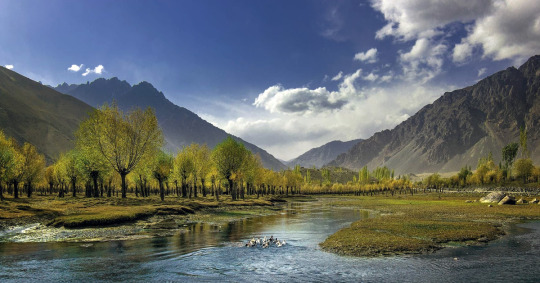
The following treks are all in an open zone, except where noted below.
NORTH-WEST BALTISTAN
To the west and south of the Basha Valley are the infrequently visited Tormik and Stak valleys. Their rarely crossed passes make for unspoiled and adventurous trekking. Only basic supplies are available in villagers, so bring everything you need. Bagicha and Dassu (1½ hours from Skardu), Stak (three hours from Skardu) and Sassi (1½ hours from Gilgit) are trailheads along the Gilgit-Skardu road. It’s easy to get on or off any daily transport between Skardu and Gilgit at any of these places.
Ganto La
Ganto La (4606m) is a pass, usually open late June to early September, linking the Basha and Tormik valleys. It’s an interesting, but steep, exit from the Basha Valley. The moderate trek starts from Hemasil in the Basha Valley, just across a stream north of Chu Tron, which means hot springs in Balti. This excellent hot spring, perfect for a pre-or post-trek soak, is around 39°C, has almost no sulphur smell, and gushes forth in a large flow. The villagers have constructed several enclosed bathhouses with doors, open ceilings and cement, walled, knee-deep pools.
It takes two or three days to cross the Ganto La to Harimal in the Tormik Valley from where you can head south to reach Dassu or Bagicha on the Gilgit-Skardu road in one easy day, or head north-west and cross Stak La. From Hemasil, ascend steeply 1000m to the ridge above Chu Tron. Camp in a meadow near huts at Matunturu. The next day, continue steeply to the Ganto La, with a permanent steep snowfield below the pass. Descend steeply to a pleasant meadow camp site called Pakora. Harimal is a short day’s walk farther.
Stak La
Stak La (4500m) links the rugged alpine Stak Nala to the green upper Tormik Valley, both of which have trailheads on the Gilgit-Skardu road. The demanding technical trek makes a four- to five-day loop and can be combined with the Ganto La trek (above). From Dassu, head north up the Tormik Valley. At Harimal (not shown on the Swiss map), the route over the Ganto La branches to the north-east. Continue up the Tormik Valley to Dunsa and Camp near the polo field by herders’ huts. At the valley’s head cross a small glacier and reach the Stak La. The west side of the pass is corniced, so bring a rope and ice axe. Descend the glacier about 500m to a grassy camp site near a large boulder. The view of Haramosh and its large eastern glacier, Khotia Lungma, is stunning. Follow the river’s true left bank as it bends south 20km to Stak Village. It’s possible to get a jeep between Stak and the Gilgit-Skardu road, 1km east of the bridge over Stak Nala. Transport in a wagon along the Gilgit-Skardu road to either Gilgit or Skardu, whereas a special hire.
HARAMOSH LA
Haramosh La (4800m) is a glaciated pass linking the Chogo Lungma and Haramosh glaciers on its north-east side with the Haramosh Valley to its west (see the Chogo Lungma Glacier map, p307). The pass is enclosed by Laila (6986m), which towers over the confluence of these glaciers, Mani (6685m) and Haramosh (7409m). This extreme nine-day technical trek, which is possible late to July to early September, crosses one of the Karakoram’s most formidable and infrequently done passes. Snow and avalanche danger are present on both side of the pass early in the season with rock fall becoming more of a danger by mid-Summer. This trek is only suited to experienced trekkers with mountaineering experience. The Haramosh La is usually crossed from east to west.
From Doko in the Basha Valley, the route follows the Chogo Lungma Glacier (see p) for the first 3½ days as far as Bolocho. From Bolocho, the route crosses the Chogo Lungma Glacier, heads south and west up the heavily crevassed Haramosh Glacier, and reaches a grassy ablation valley along the glacier’s north margin and Laila Base Camp (4100m) on Day 5.
On Day 6, rope up to reach Sharing, the level glacial basin at the base of the pass, five to six hours from Laila Base Camp. On Day 7, travel in roped teams about four hours to the pass, probing carefully for frequent crevasses. Keep to the glacier’s west side where it’s less steep and fix a rope at the steepest section near the top. Camp on top of the level, open Haramosh La. Stronger parties may prefer to combine Days 6 and 7 by leaving Laila Base Camp before dawn to ascend Haramosh La the same day, reaching the top by mid-morning.
Depending on snow conditions, you may need to fix as much as 500m of rope to descend the steep, scary snow slope on the west side of the pass on Day 8. Beware of avalanche and rock-fall danger as you descend steep scree lower down. Mani, at the bottom, is a possible camp site, but a little farther is the inviting Kutwal Lake (3260m), seven to eight hours from the pass.
Continue downvalley on a good trail on Day 9 to Dassu with views of high peaks all around. When you prearrange a vehicle, it can meet you at the roadhead in Dassu. Otherwise, walk on the road along the Phuparash River to Sassi on the Gilgit-Skardu road to catch a ride on a passing vehicle.
To attempt to cross the Haramosh La without a qualified companion who knows the route and its danger is foolhardy. Conflict between Arandu’s Balti people and Haramosh’s Shina-speakers, however, reportedly prevents Arandu porters from crossing the pass, so be sure to hire a competent Shina speaker. Local porters know the route, but don’t know where or how to fix ropes, judge avalanche or rock-fall danger, or make crevasse rescues if necessary. Wearing a climbing helmet is prudent.
It’s 14 stages total from Doko: (1) Arandu; (2) Churzing; (3) Chogo Brangsa; (4) Kurumal; (5) Bolocho; (6) Laila Base Camp; (7) Sharing; (8) Haramosh La; (9) Mani; (10) Kutwal Lake; (11) Kutwal; (12) Iskere; (13) Dassu; and (14) Sassi.
DEOSAI
Numerous little-Known routes cross the Deosai Mountains between the Indus River west of Skardu and the Astor Valley. Three valleys along the Indus River’s south bank, Shigarthang, Basho and Skoyo, have wildlife conservation programs where the likelihood of seeing wildlife is high. Trekkers can help support these initiatives by visiting them. Dambudas and Bagicha villages, marked by signs along the Gilgit-Skardu road, are where public transport drops you off. Neither village, however, is marked on maps.
Deosai Traverse
Some trekkers simply walk along the 165km-long jeep road between Skardu and Astor across the Deosai Plains in an easy four or five days (see the Burji La map,). From Skardu, the road heads south up the Satpara Valley, passing Satpara Lake and village. The road continues west across the Deosai plateau, crossing large clear streams via bridges. As it leaves the Deosai, it skirts the north shore of charming Sheoshar Lake, then crosses Sheoshar Pass (4266m, marked Chhachor Pass on the U502 Mundik (NI 43-3) map) into the Chilam Gah, which becomes the Das Khirim Gah as it descends to meet the upper Astor Valley. You can cut the walk shorter by organizing a Skardu-Satpara special hire at the start or by getting on a NATCO bus at Chilam for the daily trip to Astor village.
Nanga Parbat is visible in the distance from Deosai hilltops, but a fun two-day side trip offers never-to-be-forgotten views of Nanga Parbat. When heading north-west down the Das Khirim Gah, cross a bridge below Gudai to reach Zail. Follow a trail to the pastures above, and ascend the dry ridge to camp the first night where the entire massif stretches before you. The next day continue down the rugged Bulashbar Gah to meet the Astor Valley at its confluence with the Rupal Gah.
Alampi La and Banak La
A demanding six-day trek across either the Alampi La or Banak La, best crossed mid-June to September, links the Shigarthang and Astor Valleys. Alampi La, also used as a route between Srinagar and Skardu, was probably first crossed by Vigne in 1834-35. Banak La is a more direct and difficult route. The Shigarthang Lungma joins the Indus Valley near Kachura Lake and village (marked Katzarah on the U502 Mundik (NI 43-3) map), 30km west of Skardu on the Gilgit-Skardu road. Skardu-Kachura special hires and ones to the road’s end at Tsok. Head south-west up the Shigarthang Lungma to Shigarthang village, whose residents are Brok-pa Shina speakers. Continue west upvalley 10km to huts at Thlashing Spang where the valley divides: the west branch leads to Banak La and the south-west branch leads to Alampi La.
To Alampi La (5030m), continue up the rocky Shigarthang Lungma and camp below the pass. The ascent to the pass is over snow. The descent, initially more than 35 degrees, is extremely steep and rocky. Continue more gently to a meadow camp (4000m) in the basin below the pass. Continue 5km west down this side valley into Bubind Gah, which joins the Das Khirim Gah and the Deosai road at Gudai, two days from the meadow camp. From Gudai, a side trip offers more Nanga Parbat views (see Deosai Traverse, left).
To Banak La (4963m), follow a steep, rocky path along the stream west-north and camp above the tree line at Urdukas (3962m), 6km from Thlashing Spang. Continue up across a glacier to the pass, 6km from Urdukas. Crevasses on the glacier are covered by snow bridges until late summer, but use a rope for safety. Descend steeply 8km to Chumik (3657m) and the Urdung Gah. Continue downvalley in two days to Astor.
Dari La
A demanding three-day trek over the Dari La (4724m) links the Shigarthang Lungma with the Deosai Plains. From Shigarthang village, head east then south-east on Day 1 up the Dari Lungma and camp at the lush Dokhsun pasture below the pass. On Day 2, cross Dari La, and descend to Usar Mar at the confluence of the Burji Lungma. On Day 3, walk south the road at Ali Malik Mar and ride in a jeep back to Skardu via the Satpara Valley. Alternatively, continue north from Usar Mar and trek over the Burji La (see p), making it a five-day trek.
Naqpo Namsul La
A demanding five-day near loop trek crosses the glaciated Naqpo Namsul La (5000m), a pass near the Basho Valley’s head. The Basho Valley, whose name means ‘grape’ for the valley’s vine-yards, meets the Indus River 36km west of Skardu and 16km south of Bagicha. The Basho River provides hydroelectric power for Basho, Skoyo and Rondu. Basho village (Basha on maps) is linked with the Gilgit-Skardu road via a bridge over the Indus River. Skardu-Basho special hires. The jeep road goes another 9km up the broad valley to Sultanabad, where the residents are Brok-pa Shina speakers. Skardu- Sultanabad special hires.
From Sultanabad (Turmik on the U502 Mundik (NI 43-3) map), the trek heads south-west upvalley. It then crosses the pass into the upper Shigarthang Lungma, and descends to Kachura along the Gilgit-Skardu road. Alternatively from the upper Shigarthang Lungma, it’s possible to cross Banak La (see Alampi La and Banak La,).
Skoyo
Skoyo village, about 60km west of Skardu, is linked to the Gilgit-Skardu road via a bridge over the Indus River (under construction at the time of research). Skoyo is 4km east of Dambudas and 8km west of Bagicha. Skardu-Skoyo special hires. Skoyo villagers have implemented the Project Snow Leopard to protect the Skoyo Valley’s snow leopard population, which is dependent upon income from trekking for support. An easy three-day loop trek visits pastures beneath the summit of Takti-i- Sulaiman (5632m).
Trango Pir Pass and Harpo La
A very demanding four-day trek across either the Trango Pir Pass or Harpo La, two difficult glaciated passes, links the Tukchun Lungma to the Parishing Gah, an eastern tributary of the Astor River, and the Astor Valley. These passes are best done-mid-July to September. The trek starts from Shoat village on the Indus River’s true left (south) side, 4km west of the Dambudas and 2½ hours’ drive from Skardu. This area along the Indus River between Bagicha and Shoat, where it flows through a deep gorge called Rondu, was once a separate Kingdom. The palace of the former Raja of Rondu is in nearby Mendi. Bridges over the Indus connect both Shoat and Mendi with the Gilgit-Skardu road.
From Shoat, head south up the Tukchun Lungma, past Harpo village to Chutabar, where the valley divides: the south-west (right) branch leads to Trango Pir Pass; and the south-east (left) branch to Harpo La. Both routes have sizable markhor Populations.
To Trango Pir Pass (conflicting elevations range from 4800m to 5600m), leave the Tukchun Lungma at Chutabar and ascend the rough rocky valley. Camp below the pass near huts at Baltal. The next day, cross the pass, steep neat the top, and descend a glacier then a steep rocky spur to Thengi village in the Parishing Gah. Follow a road 10km downvalley to Astor.
To Harpo La (5115m), continue from Chutabar up the rough Tukchun Lungma 8km where the route to the pass turns south up a side stream. Continue up the side stream and camp below the pass. The ascent to the snow line is rocky. The pass is glaciated with significant avalanche danger. Descend the steep glacier on the north side below the snow line to camp. The next day continue 4km to the Urdung Gah and 10km to Thengi, and then to Astor.
Katichu La
Katichu La (4588m) is a pass linking Mehdiabad (formerly called Parkutta) on the Indus River east of Skardu to the Deosai Plains. The pass is usually snow-free July to late September and the moderate trek takes three days. Reportedly, a distant K2 is visible from the pass. When crossing from east to west, this trek is easily combined with the Burji La trek, or return to Skardu via the road down Satpara Valley. Get off the daily NATCO bus or K-2 Travel Services wagon between Skardu and Tolti/Kharmang at Mehdiabad, which depart Skardu at 1.30pm and 10am respectively.
SHIGAR AND BRALDU
Sosbun
A moderate five-day trek into the rarely visited Sosbun Valley offers wildlife-watching opportunities and, for climbers, ascents of unnamed walls and towers. Ride in a jeep from Skardu up the Braldu Valley to Chakpo (Chokpoing on the Swiss map) and camp. Trek up the Hoh Lungma to camp at Nangmah (Nangmoni Tapsa on the Swiss map). Cross the Sosbun Glacier to Jusma camp at the base of the spur between the Tsilbu and Sosbun glaciers. Trek up the Sosbun Glacier to Sosbun Base Camp at the base of the spur between the South and North Sosbun glaciers beneath Sosbun Brak (6413m). Return in two days to Chakpo.
Skoro La
Skoro La (5073m) is a little-used pass, first crossed by Falconer in 1838, linking Askole in the Braldu Valley to Namika and Shigar in the Shigar Valley (see the Baltoro Glacier map,). This pass was more frequently used before the road was completed up the Braldu Valley to Askole. It offers an alternative, demanding three-day trek between Askole and Shigar, useful when the road is blocked.
From Askole, cross the Braldu River on a footbridge and ascend steeply to Thal Brok, with fine views. Continue up the Skoro La Lungma’s west bank and camp at Darso Brok, a summer pasture at the Skoro La Glacier’s edge. The next day continue up the glacier, over snow three to four hours, then turn west and climb to the Skoro La. Descend 450m steeply over snow and rock to the steep grassy slopes below. Camp here or descend another 900m to the Skoro Lungma’s head to camp. The next day, follow the stream, crossing it continuously, with several steep sections, to Namika on the road in the Shigar Valley, 6.5km north of Shigar.
Panmah Glacier
The 42-km long Panmah Glacier forms the Dumordo River, which flows into the Biaho Lungma between Korophon and Jula (see the Baltoro Glacier map,). Askole villagers use summer pastures along this glacier. The Panmah is fed by two large glaciers, Choktoi to the north-west and Nobande Sobande to the north-east. The Choktoi leads to the base camp for the north face of the Latok spires. At its head is the difficult Sim La (5833m), which crosses Baintha Brak’s north shoulder. The entire area is in a restricted zone where a permit and licensed guide are required (see Trekking permit,). During the 1990s, experienced Westerners pioneered scenic and extreme technical treks here.
Treks begin from Thungol in the Braldu Valley. The approach follows the Dumordo River’s true left (east) bank, crosses to its true right bank below the Panmah Glacier’s snout, then continues along its east margin. Technical passes at the head of two eastern side glaciers, First Feriole and South Chiring, lead to the Trango and Baltoro glaciers. The First Feriole is reported to be the easier of the two. Continuing north up the Panmah Glacier, you cross the Chiring Glacier and reach the meadow of Skinmang (many ibex), a fine base for exploring the upper glaciers. The Nobande Sobande is reported to be mostly crevasse free with spectacular scenery. An unnamed pass just east of Biacherahi Tower enables parties to cross to the Choktoi Glacier and return to the Panmah Glacier in a five-day loop.
A longer near-loop trek is possible by crossing the Skam La (5407m) at the Nobande Sobande’s head, and following the Sim and Biafo glaciers back to Thungol. The east side of Skam La is reported to be straightforward, but the west side requires fixing as much as 300m of rope.
Conditions in this area can change in 1887 Younghusband found the Nobande Sobande inaccessible with ice blocks the size of house; in 1929 Ardito Desio found it remarkably smooth and was able to ski to its head; and the 1937 Shipton-Tilman expedition found it almost impassable, ‘broken by gaping crevasses and Tumbled masses of ice’. Technical trekkers must be prepared for the logistical challenges and changing conditions. Guides and porters don’t yet know these routes. If you hire someone make sure they’re adequately equipped for the rigours.
KHAPLU
From Khaplu’s, main bazaar, a 45 minute walk leads past the polo ground to the palace of the Raja of Khaplu, with its impressive four-storey wooden balcony above the entrance. A steep 20 minutes farther is Chakchun village, with an old mosque, and fine views across the Shyok River of Masherbrum at the Hushe Valley’s head.
Ghanche Tso
From the powerhouse at the upper end of the road, beyond the K-7 Hotel, it’s an easy seven- to eight- hour walk (two stages) up the Ghanche River to Ghanche Tso (lake).
Daholi Tso
From the polo ground, a jeep road climbs south-east to the summer settlements of Khaplutung and Hanjore, easy 1½ and 2½ hours’ walks, respectively, from the polo ground. The entire upper settled area, which is called Khaplu Brok, has great Masherbrum views. From Hanjore, a trail climbs behind the ridge in one long day (two stages) to Daholi Tso (lake).
Hushe
Honbrok
Picturesque Honbrok summer pastures high above the Hushe River west of Hushe village are easily visited on a day hike. It takes four hours to climb steeply to the pastures and 1½ to two hours to return to Hushe. Cross the Hushe River on the lower of the two footbridges to its true right bank. Walk up 15 to 30 minutes to Honbrok Nala. Cross it on a sturdy wooden footbridge. The trail ascends the stream’s true left (north) bank all the way to the pastures. Honbrok has reliable spring water. June to October is the best season. Honbrok is labeled Honboro on the Swiss map. Hushe-pa also refer to Honbrok Peak (6459m) as Cigarette Peak.
Aling Glacier
The Aling Glacier, the westernmost of Hushe Valley’s glaciers, is very large with multiple upper branches. Two summits above the upper glaciers, Mitre (5944m) and Sceptre (5800m), attract climbers. From Hushe, cross the river to its west bank and reach the footbridge over the Aling River in two hours. Across the footbridge, the trail turns west into the Aling Valley to Dumsum, a summer village with a two storey mosque. Continue west along the Aling River’s true left (north) bank to Shatonchen pastures, and along the Aling Glacier’s north margin to base camp and Drenmogyalba (royal bear), the highest pasture.
Hushe-pa have 14 stages (one-way) up the demanding route, but no one goes beyond the seventh stage. The seven one-way stages starting from Hushe are: (1) Dumsum; (2) Shatonchen: (3) Base Camp; (4) Drenmogyalba; (5) Sampibrangsa; (6) Khadanlumba; and (7) Tasa.
K6 Base Camp
K6 (7281m), also called Baltistan Peak, is usually approached from Kande village, midway up the Hushe Valley (see the K7 Base Camp map,). The steep granite walls that line the Nangmah Valley, including the Great Tower (5800m) south of the summer pastures, make this a popular rock-climbing destination.
From Kande, cross a footbridge over the Hushe River, then cross to the Nangmah River’s true right (north) bank and Mingyulu village (labeled Minjlu on the Swiss map). Continue up the river’s north bank to Nangmah summer pastures and on to K6 Base Camp along the Nangmah Glacier’s north-west margin. Kande’s K6 Hotel and Restaurant, above the road’s west side, is the place to hire porters. The moderate trek totals six stages: three stages from Kande to K6 Base Camp; and three stages to return via the same route.
KONDUS AND SALTORO
The beautiful Kondus and Saltoro valleys have been in a closed zone since the dispute between Pakistan and India over the Siachen Glacier began in 1984. These valleys were always the preferred approach route to the peaks along the giant Siachen. The southern approach to the Siachen, up the Nubra Valley, was impossible in summer due to high water and quicksand. Now, Kondus and Saltoro villagers no longer see expeditions and so lose the opportunity to earn much-needed income. These eastern Baltistan valleys have some of the finest clean granite towers in Baltistan, rivaling the Trango Towers for size and sheer vertically. Despite the closed status of the valleys, climbers have their eye in first ascents of big walls in these valleys, and the Pakistan government has shown signs of relaxing the restrictions. In the summer of 2000, a group of US rock climbers received a trekking permit for the Kondus Valley and made a first ascent of a 5000m tower just above Karmading village. Contact the Tourism Division (see Trekking Permits,) through a trekking company to request permission-it may say no, but it might say yes!
From Halde village in the lower Hushe Valley, across the river from Machulu, a jeep road follows the Saltoro River’s true right (north) bank through Tsino (Chino on the Swiss map) with its magnificent granite towers to Brakhor where the valleys divide: Kondus it to the north, and Saltoro to the east.
Kondus
The road up the Kondus Valley goes to Karmading, the highest village. A few hours’ moderate walk above Karmading to the north-east is the Khorkondus Valley and Khorkondus village. A waterfall tumbles over granite cliffs behind the village, and a small hot spring is 15 minutes north. The towers above Karmading can be approached without traversing a glacier. Above, the Sherpi Gang descends from Sherpi Kangri (7380m) and Saltoro Kangri (7742m). Above the pastures called Lisar (hunting ground) are clean granite walls, a climber’s delight. From Karmading, a trail leads up the main valley under the Karmading Wall several hours to the Kondus Glacier’s snout. It’s two stages to the highest pasture, Rahout Chen, passing through Byangeparo near the confluence of the Kaberi and Kondus glaciers en route. The Kondus Glacier is perhaps the Karakoram’s most difficult and chaotic glacier, but beautiful clean granite pinnacles rise above its upper reaches. From the Kaberi Glacier, some technical passes lead to Hushe’s Tsarak Tsa Valley.
Saltoro
From Brakhor in the Saltoro Valley, a bridge crosses to the river’s south bank. The road up the Saltoro Valley follows the south bank to Goma, the highest village. Women in the Saltoro Valley wear unique red- dyed raw wool hats with brown beaver-like tails. At Goma, the Bilafond, Gyang and Chulung streams meet, descending from the glaciers above. The Bilafond Glacier is also renowned for its granite towers. Beyond the passes above these glaciers are Indian troops.
0 notes
Last Seen Blogs

the-nameless-witch
https://www.touchoflighting.com

cara--olivia-blog
{a heart full of love}

glitterxxkitten
Entropy

italy1stan
Italy1Stan
lucbron-blog
Luc Bron Architecte