#lake mead national recreation area
Video
Light Traffic by James Marvin Phelps
Via Flickr:
Light Traffic Hoover Dam Nevada-Arizona
#nevada#arizona#hoover dam#intake towers#dam#black canyon#colorado river#lake mead#usa#southwest#water#reservoir#drought#climate change#river#lake#las vegas#photography#bureau of reclamation#lake mead national recreation area#james marvin phelps photography#night#lights#light trails#flickr
25 notes
·
View notes
Text
Park rangers at Lake Mead National Recreation Area just outside Las Vegas are asking for the public's help identify two people caught on video vandalizing natural rock formations earlier this month.
3 notes
·
View notes
Video
youtube
Lake Mead National Recreation Area Views (Video Game Speed)
1 note
·
View note
Text
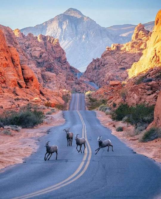
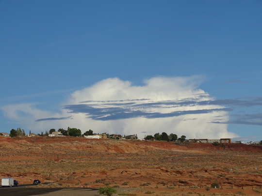
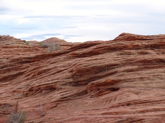
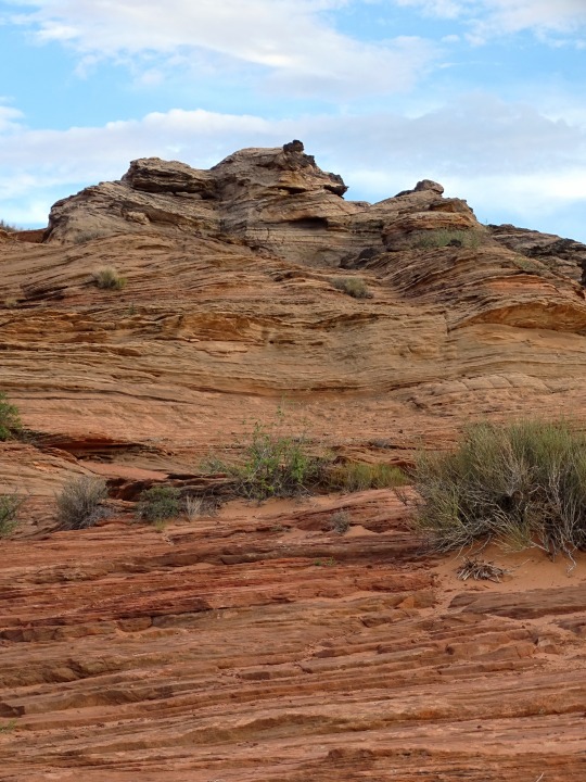
➤ Valley of Fire State Park is a public recreation and nature preservation area covering nearly 46,000 acres (19,000 ha) located 16 miles (26 km) south of Overton, Nevada. The state park derives its name from red sandstone formations, the Aztec Sandstone, which formed from shifting sand dunes 150 million years ago. These features, which are the centerpiece of the park's attractions, often appear to be on fire when reflecting the sun's rays. It is Nevada's oldest state park, as commemorated with Nevada Historical Marker #150. It was designated as a National Natural Landmark in 1968. Valley of Fire is located in the Mojave Desert 50 miles (80 km) northeast of Las Vegas, at an elevation between 1,320–3,009 feet (402–917 m). It abuts the Lake Mead National Recreation Area on the east at the Virgin River confluence. It lies in a 4 by 6 mi (6.4 by 9.7 km) basin.
📷@codymayer22
61 notes
·
View notes
Photo
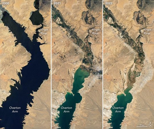
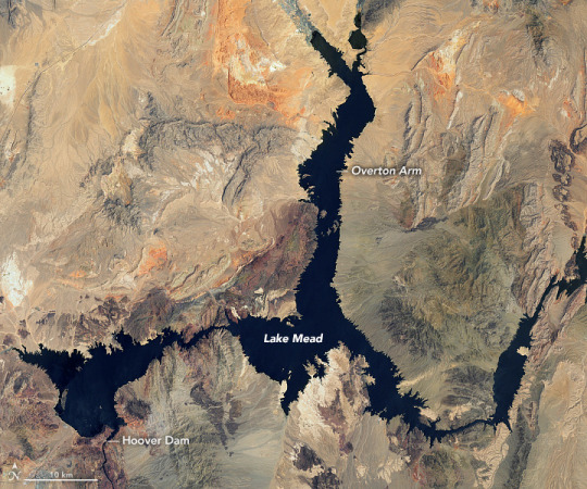
Lake Mead Keeps Dropping
Continuing a 22-year downward trend, water levels in Lake Mead stand at their lowest since April 1937, when the reservoir was still being filled for the first time. As of July 18, 2022, Lake Mead was filled to just 27 percent of capacity.
Continuing a 22-year downward trend, water levels in Lake Mead stand at their lowest since April 1937, when the reservoir was still being filled for the first time. As of July 18, 2022, Lake Mead was filled to just 27 percent of capacity.
The largest reservoir in the United States supplies water to millions of people across seven states, tribal lands, and northern Mexico. It now also provides a stark illustration of climate change and a long-term drought that may be the worst in the U.S. West in 12 centuries.
The low water level comes at time when 74 percent of nine Western states face some level of drought; 35 percent of the area is in extreme or exceptional drought. In Colorado, location of the headwaters of the Colorado River, 83 percent of the state is now in drought, and the snowpack from last winter was below average in many places.
The natural-color images above were acquired on July 6, 2000, and July 3, 2022, by Landsat 7 and Landsat 8. The detailed images below also include a view from Landsat 8 on July 8, 2021 (middle). The light-colored fringes along the shorelines in 2021 and 2022 are mineralized areas of the lakeshore that were formerly underwater when the reservoir was filled closer to capacity. The phenomenon is often referred to as a “bathtub ring.”
The lake elevation data below come from the U.S. Bureau of Reclamation (USBR), which manages Lake Mead, Lake Powell, and other portions of the Colorado River watershed. As of July 18, 2022, the water elevation at the Hoover Dam was 1041.30 feet (317.4 meters) above sea level; the water elevation at the end of July 2000 (around the time of the Landsat 7 image above) was 1199.97 feet (341 meters). Lake levels at the dam should stay above 1000 feet to continue operating hydropower turbines at normal levels.
At maximum capacity, Lake Mead would reach an elevation 1,220 feet (372 meters) near the dam and would hold 9.3 trillion gallons (36 trillion liters) of water. The lake last approached full capacity in the summers of 1983 and 1999.
About 10 percent of the water in Lake Mead comes from local precipitation and groundwater each year, with the rest coming from snowmelt in the Rocky Mountains that flows down the Colorado River watershed through Lake Powell, Glen Canyon, and the Grand Canyon. The Colorado River basin is managed by USBR and other agencies to provide electric power and water to roughly 40 million people—most notably the cities of San Diego, Las Vegas, Phoenix, Los Angeles—and 4 to 5 million acres of farmland in the Southwest. The river water is allotted to states (including tribal lands) and Mexico through laws like the 1922 Colorado River Compact.
Above Lake Mead, Lake Powell is currently filled to just 27 percent of capacity, and the entire Colorado river system stands at 35 percent. USBR announced in August 2021 that state water allocations would be cut in 2022; further modeling and negotiation is underway for 2023 allocations. In June 2022, USBR issued an emergency request to the Colorado River basin states to reduce water usage by 2 million to 4 million acre-feet over the next 18 months.
In addition to serving as a major drinking and irrigation source for the Southwest, Lake Mead is a national recreation area that is particularly popular with boaters. According to the National Park Service, five of six boating ramps/launches are now closed. “Declining water levels due to climate change and 20 years of ongoing drought have reshaped the park’s shorelines,” the Park Service said on its website. “As Lake Mead continues to recede, extending launch ramps becomes more difficult and more expensive due to the topography and projected decline in water levels.”
NASA Earth Observatory images by Lauren Dauphin, using Landsat data from the U.S. Geological Survey and and lake elevation data from the Bureau of Reclamation. Story by Michael Carlowicz.
409 notes
·
View notes
Text
My fiance asked me a while ago: "Hey, Arcade, why is Fortification Hill called that?"
I went to Google, naively thinking Google would have an answer for me. It didn't. I told my fiance I couldn't find it, Z complained about that, life went on.
A few weeks later, I'm trying to procrastinate on a GIS project. I think "Hey, maybe if I call Lake Mead National Recreation Area, they'll know something! I think Fortification Hill is in the recreation area." So I call Lake Mead.
"Hello, this is Lake Mead National Recreation Area."
"Why is Fortification Hill called Fortification Hill?"
"What?"
"How did Fortification Hill get its name?"
"I don't know what that is."
"It's by Lake Mead."
"Oh. [Presumably checks what it is] I dunno, prolly because it looks like a fort? I'll go check."
I get put on hold, and then the call hangs up. Great, Lake Mead hung up on me. I think that maybe someone in Mohave County would know, as that is where the hill is located.
I call the Mohave County Historical Preservation Society. They don't understand me at first because I talk too fast, and when they do understand me, they don't know what I'm talking about. They put me through to their research department. The researcher was a wonderful woman who had no idea what I was talking about, and she found it very funny that Lake Mead had just hung up on me.She did get my name, number, and my email address, and she promised to look into it. She told me to "try calling Boulder".
In context, that probably means "go call someone else in Boulder City", so I look up their historical society. I call the number Google gives me. It is the number for the part of the Boulder City government that does building inspections. The building inspectors probably wouldn't know, but I didn't ask them.
Next I try calling the Boulder City/Hoover Dam Museum. They have a research library with books on the Lower Colorado River, which I think includes Lake Mead? They don't pick up, so I leave them a voicemail they will almost assuredly never hear.
I mention all this on a Discord server I'm in, and someone from Kingman, Arizona says they'll go look into it for me. I don't think they'll be able to get me anything but I appreciate the sentiment. I'm not sure where to go from here. I've called four people and not gotten any closer to a straight answer on how this hill got named. If I ever get a restraining order taken out against me by the entire Las Vegas metropolitan area, this will be why. If anyone who sees this has a lead, let me know? Now that the information has eluded my grasp so long, I want it.
9 notes
·
View notes
Photo
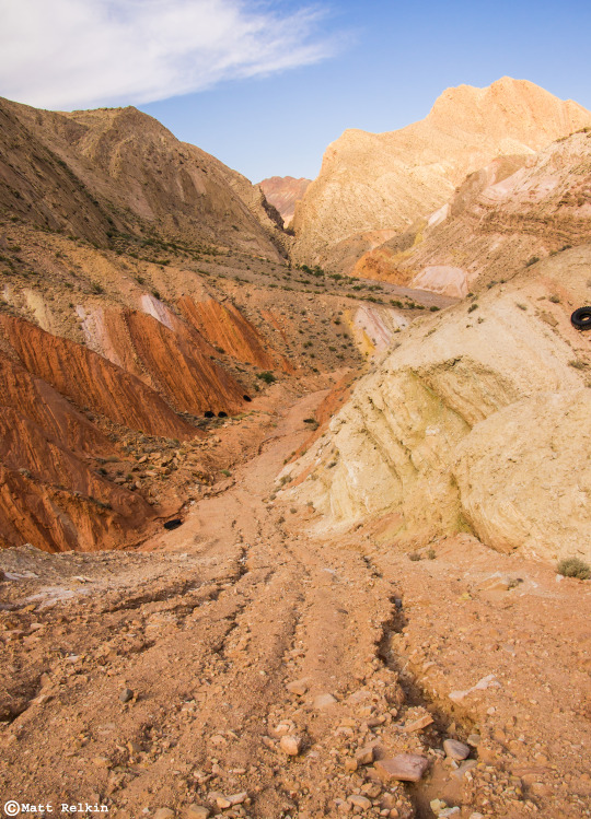
AM Rd 2, Lake Mead National Recreation Area, NV
64 notes
·
View notes
Text


Glen Canyon National Recreation Area, AZ (No. 8)
Glen Canyon Dam's most vital purpose is to provide storage to ensure enough water flows from the Upper Colorado River Basin to the lower, especially in drought years. The 1922 Colorado River Compact requires annual delivery of 7.5 million acre-feet (9.3 km3) to the Lower Basin states of Arizona, California and Nevada; the 1944 treaty with Mexico obligates the U.S. to allow at least 1.5 million acre-feet (1.9 km3) for use in the Mexican states of Baja California and Sonora. Glen Canyon Dam must supply at least 8.23 million acre-feet (10.15 km3) of this water; the remaining 770,000 acre-feet (0.95 km3) comes from other tributaries of the Colorado River.[125] The required release from Glen Canyon is averaged over a 10-year period, so releases in each year may be higher or lower depending on the amount of runoff. In wetter years, the Bureau of Reclamation may decide to release extra water from Glen Canyon Dam if the level of Lake Powell exceeds the "equalization tier", an elevation determined by the difference in storage between Lake Powell and Lake Mead.
Most of Lake Powell's inflow originates as summer snowmelt from the Rocky Mountains of Colorado, Utah and Wyoming. Releases are made over a water year of October 1–September 30, since the annual snowpack begins to accumulate in late autumn. On April 1 of each year, the Bureau of Reclamation releases its official forecast of the April–July (snowmelt season) runoff, and adjusts releases from Glen Canyon Dam accordingly to maintain Lake Powell at a safe level. An accurate forecast is vital to prevent uncontrolled spilling, which would waste water that could have been used for power generation. Although the snowpack typically reaches its peak and begins to melt in April, the picture can occasionally change unexpectedly and dramatically – either due to a hot and dry spring that evaporates snow before it can melt, or an extremely wet spring as occurred in May 1983. After the near disaster in 1983, the USBR has maintained a minimum of 2.4 million acre-feet (3.0 km3) of flood-storage space in Lake Powell at the beginning of each year, to guard against unanticipated high runoff.
Source: Wikipedia
#Glen Canyon Dam Overlook#Glen Canyon National Recreation Area#Glen Canyon NRA#GCNRA#Coconino County#Southwestern USA#Colorado Plateau#desert#flora#nature#blue sky#clouds#grass#travel#original photography#vacation#tourist attraction#landmark#landscape#countryside#USA#Arizona#summer 2022#red rock#Page#engineering#technology#Colorado River
4 notes
·
View notes
Text
National Park Service personnel are investigating another witness report of human remains found at Lake Mead, the agency announced Monday.
Few details were made available about the apparent discovery at the time of the announcement, which the NPS released soon after park rangers received the witness report around 4:30 p.m. EST. According to the NPS, an unidentified person uncovered the body while visiting a portion of Lake Mead National Recreation Area called Swim Beach, located in the reservoir's boulder basin area about 30 miles east of Las Vegas.
Park rangers arrived at the scene on Monday afternoon, the NPS said. While rangers set a perimeter to mark and close off the area where they intended to recover the reported remains, officials notified the Clark County Medical Examiner who will determine a cause of death. As a formal investigation into the incident is ongoing, authorities said they could not yet provide any additional information.
Monday's discovery was the latest in an unnerving series of similar reports. As a severe and ongoing drought caused the water level at Lake Mead — the largest reservoir in the United States, spanning roughly 120 miles between eastern Nevada and western Arizona — to sink to its lowest point in nearly a century, human remains were found near its new shores multiple times this year.
Days after boaters spotted a barrel carrying a body at Hemenway Harbor, just three miles away from Swim Beach, last May, the NPS reported that human skeletal remains were discovered about 25 miles north at a different section of Lake Mead called Callville Bay. Local police later said they had identified the body found at Hemenway Harbor as a shooting victim whose shoes indicated that they were likely killed in the mid-1970s or early 1980s.
#nunyas news#this shouldn't be terribly surprising#brother does scuba in tahoe#all kinds of dead divers there#too dangerous to go pick them up#probably a fair number of murder victims too
30 notes
·
View notes
Photo


Lake Mead Keeps Dropping Continuing a 22-year downward trend, water levels in Lake Mead stand at their lowest since April 1937, when the reservoir was still being filled for the first time. As of July 18, 2022, Lake Mead was filled to just 27 percent of capacity. The largest reservoir in the United States supplies water to millions of people across seven states, tribal lands, and northern Mexico. It now also provides a stark illustration of climate change and a long-term drought that may be the worst in the U.S. West in 12 centuries. The low water level comes at time when 74 percent of nine Western states face some level of drought; 35 percent of the area is in extreme or exceptional drought. In Colorado, location of the headwaters of the Colorado River, 83 percent of the state is now in drought, and the snowpack from last winter was below average in many places. The natural-color images above were acquired on July 6, 2000, and July 3, 2022, by Landsat 7 and Landsat 8. The detailed images below also include a view from Landsat 8 on July 8, 2021 (middle). The light-colored fringes along the shorelines in 2021 and 2022 are mineralized areas of the lakeshore that were formerly underwater when the reservoir was filled closer to capacity. The phenomenon is often referred to as a “bathtub ring.” The lake elevation data below come from the U.S. Bureau of Reclamation (USBR), which manages Lake Mead, Lake Powell, and other portions of the Colorado River watershed. As of July 18, 2022, the water elevation at the Hoover Dam was 1041.30 feet (317.4 meters) above sea level; the water elevation at the end of July 2000 (around the time of the Landsat 7 image above) was 1199.97 feet (341 meters). Lake levels at the dam should stay above 1000 feet to continue operating hydropower turbines at normal levels. At maximum capacity, Lake Mead would reach an elevation 1,220 feet (372 meters) near the dam and would hold 9.3 trillion gallons (36 trillion liters) of water. The lake last approached full capacity in the summers of 1983 and 1999. About 10 percent of the water in Lake Mead comes from local precipitation and groundwater each year, with the rest coming from snowmelt in the Rocky Mountains that flows down the Colorado River watershed through Lake Powell, Glen Canyon, and the Grand Canyon. The Colorado River basin is managed by USBR and other agencies to provide electric power and water to roughly 40 million people—most notably the cities of San Diego, Las Vegas, Phoenix, Los Angeles—and 4 to 5 million acres of farmland in the Southwest. The river water is allotted to states (including tribal lands) and Mexico through laws like the 1922 Colorado River Compact. Above Lake Mead, Lake Powell is currently filled to just 27 percent of capacity, and the entire Colorado river system stands at 35 percent. USBR announced in August 2021 that state water allocations would be cut in 2022; further modeling and negotiation is underway for 2023 allocations. In June 2022, USBR issued an emergency request to the Colorado River basin states to reduce water usage by 2 million to 4 million acre-feet over the next 18 months. In addition to serving as a major drinking and irrigation source for the Southwest, Lake Mead is a national recreation area that is particularly popular with boaters. According to the National Park Service, five of six boating ramps/launches are now closed. “Declining water levels due to climate change and 20 years of ongoing drought have reshaped the park’s shorelines,” the Park Service said on its website. “As Lake Mead continues to recede, extending launch ramps becomes more difficult and more expensive due to the topography and projected decline in water levels.” NASA Earth Observatory images by Lauren Dauphin, using Landsat data from the U.S. Geological Survey and and lake elevation data from the Bureau of Reclamation. Story by Michael Carlowicz.
2 notes
·
View notes
Photo

Me with my Mom and Aunt Ruby at Lake Mead from the Sunset View Scenic Overlook in Boulder, NV, facing Arizona from across the Lake! This was our favorite spot at the lake, and this is also one of the most scenic spots at the Lake! Traveling with Family and enjoying beautiful places like these together, is one of the best experiences in life! Photographed on May 31, 2022. Have a Super Saturday and Weekend, everyone! 🏞🧍🏻♀️🧍🏻♀️🧍🏻♀️📷 #lasvegas @lasvegas #lakemead @lakemeadnps #visitlasvegas @visitlasvegas #vegasexplores @vegas.explores #vegasshooters @vegasshooters #travelnevada @travelnevada #visitnevada @visitnevada #explore_nevada @explore_nevada #nvnag @nevada_magazine #onlyinNV @onlyinNV #exploredesertcities @exploredesertcities #raw_travelblog #raw_people #raw_landscapes #raw_waters #raw_vip_gold #bestofthe_usa @bestoftheusa_water #yes_busa #wb_water_brilliance #water_captures #awesomeportrait #photofeaturewater #ig_northamerica @ig_northamerica #just_unitedstates @just_unitedstates #futurewomenphotography @futurewomenphotography #tuttlecameras @tuttlecameras #creativephotoacademy @creativephotoacademy #californiacenterdigitalarts @californiacenterdigitalarts #nikonnofilter #nikonlove @nikonusa (at Lake Mead National Recreation Area - National Park Service) https://www.instagram.com/p/CeY-WFWpPJr/?igshid=NGJjMDIxMWI=
#lasvegas#lakemead#visitlasvegas#vegasexplores#vegasshooters#travelnevada#visitnevada#explore_nevada#nvnag#onlyinnv#exploredesertcities#raw_travelblog#raw_people#raw_landscapes#raw_waters#raw_vip_gold#bestofthe_usa#yes_busa#wb_water_brilliance#water_captures#awesomeportrait#photofeaturewater#ig_northamerica#just_unitedstates#futurewomenphotography#tuttlecameras#creativephotoacademy#californiacenterdigitalarts#nikonnofilter#nikonlove
2 notes
·
View notes
Video

flickr
Mojave Milky Way by James Marvin Phelps
Via Flickr:
Mojave Milky Way Blue Hour Lake Mead National Recreation Area Clark County, Nevada September 2023
#nevada#lake mead national recreation area#mojave desert#blue hour#milky way#astrophotography#landscape#photography#james marvin phelps photography#flickr
7 notes
·
View notes
Text
0 notes
Text
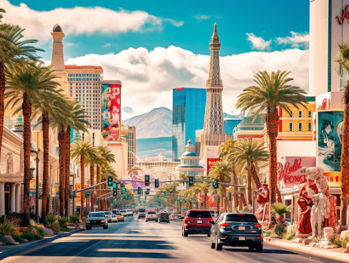
Escape the Glitter: 13 Awesome Places to Visit Near Las Vegas by Car
Las Vegas, the dazzling city of lights, beckons with its world-class casinos, extravagant shows, and electrifying nightlife. But beyond the neon glow lies a vast and diverse landscape waiting to be explored. Buckle up and hit the open road – here are 13 incredible destinations, all accessible by car from Las Vegas, that offer a welcome escape from the Vegas buzz:

Red Rock Canyon National Conservation Area: A mere 23-minute drive west, Red Rock Canyon stuns with its fiery red sandstone cliffs, sculpted by millions of years of wind and erosion. Hike scenic trails, witness ancient petroglyphs, or take a scenic drive for panoramic views. Click here
Valley of Fire State Park, Nevada: Travel 56 minutes northeast to discover a photographer's paradise. Valley of Fire boasts vibrant red Aztec sandstone formations, petrified trees, and ancient petroglyph panels. Hike scenic trails like the Mouse's Tank Loop or marvel at the landscape from scenic overlooks.
Hoover Dam, Nevada/Arizona: A 45-minute drive southeast takes you to a marvel of human engineering - the Hoover Dam. Witness the immense power of the Colorado River harnessed by this colossal concrete structure. Explore the dam's interior on a guided tour or take in the breathtaking views from the Mike O'Callaghan-Pat Tillman Memorial Bridge.Click here
Lake Mead National Recreation Area: Cool off at Lake Mead, just 40 minutes from the Strip. This massive reservoir offers boating, fishing, swimming, and stunning desert scenery. Explore the various coves and beaches, or visit the historic Mormon settlements and viewpoints surrounding the lake.
Grand Canyon National Park – West Rim: Embark on a 2-hour and 13-minute adventure to the Grand Canyon's West Rim. Witness the awe-inspiring grandeur of this natural wonder, walk along the thrilling glass Skywalk, or take a helicopter tour for unparalleled aerial views.
Death Valley National Park, California: For a taste of extremes, head 2 hours and 22 minutes east to Death Valley National Park, the hottest, driest place in North America. Explore otherworldly landscapes like Badwater Basin, the lowest point in North America, or hike through Zabriskie Point for panoramic vistas. Click here
Seven Magic Mountains, Nevada: Take a 35-minute southwards jaunt for a whimsical art installation. Seven Magic Mountains features colorful, towering rock sculptures set against the stark desert backdrop, making for a unique and Instagram-worthy stop.
Zion National Park, Utah: A 2-hour and 35-minute drive leads to Zion National Park, a wonderland of red sandstone cliffs, slot canyons, and cascading waterfalls. Hike the iconic Narrows, a slot canyon carved by the Virgin River, or explore the park's diverse trails offering breathtaking scenery.
Mount Charleston: Escape the desert heat with a 48-minute drive up Mount Charleston. This forested mountain range offers cooler temperatures, scenic hiking trails, and a chance to spot wildlife like bighorn sheep. During winter, enjoy snowshoeing or skiing at the Lee Canyon Ski Resort. Click here
Oatman, Arizona: Cruise 1 hour and 13 minutes south to Oatman, a quirky wild west ghost town. Burros roam freely, and visitors can interact with these friendly (and sometimes mischievous) creatures. Explore the historic buildings and shops lining the dusty main street.
Sedona, Arizona: Immerse yourself in the spiritual energy of Sedona, a 2-hour and 30-minute drive away. Hike amidst majestic red rock formations, visit ancient Native American ruins, or embark on a jeep tour for off-road adventures. Sedona is also known for its vibrant arts scene and metaphysical shops.
Laughlin, Nevada: Seeking a change of pace but craving Vegas vibes? Head 90 minutes south to Laughlin, a mini Las Vegas on the banks of the Colorado River. Enjoy casinos, riverboat cruises, and a more relaxed atmosphere compared to the bustling Strip.
Bryce Canyon National Park: For an unforgettable stargazing experience, take a 4-hour drive to Bryce Canyon National Park. Hike along the rim, marveling at the unique hoodoos (tall, thin rock spires), or descend into the amphitheater for breathtaking views. At night, witness a dazzling display of stars due to minimal light pollution.
Learn more:
Top Places to Visit In Chikmagalur in 3 Days 2024
Hirekolale Lake Itinerary: Complete Travel Guide.
Best Area To Stay In Costa Rica 2024
0 notes
Text
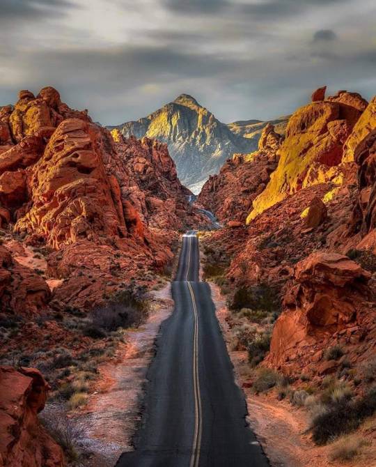
➤ Valley of Fire State Park is a public recreation and nature preservation area covering nearly 46,000 acres (19,000 ha) located 16 miles (26 km) south of Overton, Nevada. The state park derives its name from red sandstone formations, the Aztec Sandstone, which formed from shifting sand dunes 150 million years ago. These features, which are the centerpiece of the park's attractions, often appear to be on fire when reflecting the sun's rays. It is Nevada's oldest state park, as commemorated with Nevada Historical Marker #150. It was designated as a National Natural Landmark in 1968. Valley of Fire is located 50 miles (80 km) northeast of Las Vegas, at an elevation between 1,320–3,009 feet (402–917 m). It abuts the Lake Mead National Recreation Area on the east at the Virgin River confluence. It lies in a 4 by 6 mi (6.4 by 9.7 km) basin.
📷@daniel_kaufman_photography
69 notes
·
View notes
Last Seen Blogs

yamoulouk
Sans titre

pusatmebel
Pusat Jual Mebel

johncystal
Untitled

yahoo-style-de
Yahoo Style

i-walk-in-air
I-Walk-In-Air