
Last Seen Blogs

blissf-lly
fengshuisecretsrevealed.com

kenungofficial-blog
Untitled

kajalvermas
Untitled

ketosummit
Keto Summit

l0ztgh0zt
Azrael
Text
Where will i find the Most Up-to-Date Satellite Imagery?

when some of the first cameras were strapped to balloons and kites, Earth observation technology and satellite imagery sources have come a long way since 1840. Until a few decades ago, Earth Observation imagery acquired by satellites captured only selected areas at low-resolution mainly for military purposes.
The global commercial satellite imaging market was estimated at $2,240.0 million in 2018 and is projected to reach $5,256.4 million by 2026, registering a CAGR of 11.2% from 2019 to 2026.
Satellite imagery is used for commercial purposes in a variety of applications, including environmental monitoring and management, energy resource protection, border control, and construction project mapping.
One of the primary benefits of satellite imaging is quicker image processing, which allows for more extensive earth coverage, making commercial satellite imaging services a favored option over other imaging services.
Commercial Satellite Imaging Market Segments:
By Application
Geospatial Data Acquisition & Mapping
Urban Planning & Development
Disaster Management
Energy & Natural Resource Management
Surveillance & Security
Defense & Intelligence
Others
By End User
Government
Military Defense
Forestry & Agriculture
Energy
Civil Engineering & Archaeology
Transportation & Logistics
Others
How can satellite imagery help your business?
Transportation, civil engineering, finance & insurance, real estate, oil, land administration and mapping, agriculture, humanitarian aid, and other industries rely heavily on Earth Observation data.
At the same time, it's important to remember that getting access to data and gaining actionable information from it usually takes a lot of time and money.
Cloudeo is a marketplace that allows everyone to build, train, and run detectors on satellite and aerial imagery.
Hexagon Pixel Delivery:
Hexagon Pixel delivery provides the highest quality aerial imagery data set of North America and Europe via WMS/WMTS streaming service.
SI Imaging Service:
SI Imaging is the exclusive company provider of high-resolution satellite imagery (both optical and radar) across more than 110 countries around the globe.
Cloudeo marketplace has both tasking and archive imagery fromAirbus Defence and Space is the world's second-largest space corporation and a major producer of satellites for Earth observation, navigation, and telecommunications. 2006 to present. SIIS is the exclusive distributor of the satellite imagery obtained by KOMPSAT-2A, KOMPSAT-3A, KOMPSAT-3 and KOMPSAT-5A satellites.
Where you can apply
natural disasters
volcanic and seismic activity prediction (due to temperature-sensitive sensors usage)
water currents monitoring
natural resources control as well as forestry management improvement
maps designing
data acquisition for GIS (Geographic Information Systems)
Airbus
Airbus Defence and Space is the world's second-largest space corporation and a major producer of satellites for Earth observation, navigation, and telecommunications.
Cloudeo marketplace provide high-resolution satellite imagery from the following satellites: Pléiades, TerraSAR-X Archive, OneAtlas and SPOT 6/7 Archive.
TripleSat
A new high-resolution sensor can track any location on the planet and reveal information as small as 80 cm with TripleSat constellation.
Where you can apply
Management of land use, forests, and urban infrastructure
Crop Monitoring and agricultural findings
Exploration for oil and gas
Operational disaster relief and emergency response
Surveillance in the maritime and littoral zones
Defense, intelligence derived from imagery, and tactical preparation.
Civil engineering and 3D modeling, as well as visualization, are all aspects of civil engineering.
Planet
Planet provides organizations with the data they need to make educated, timely decisions by providing geospatial insights at the pace of change.
Planet Basemap, Planet Archive , and Rapideye are the following Satellite imagery products clouded offers.
Benefits of using satellite Imagery:
There are many benefits of using satellite imagery. It can be used to monitor weather systems with great precision, particularly dangerous storms like hurricanes. Since satellites orbit the Earth, their imaging operation can be easily replicated. It also allows for much larger coverage areas, and since all data is digital, it is simple to incorporate with applications. In certain situations, cloud cover has no impact on the outcome.
Changes in the climate
Global surface temperatures are rising, sea levels are rising, ice is melting, and changes in weather patterns are causing heavy rainfall and flooding in some areas while causing catastrophic droughts in others.
Deforestation
Deforestation has significant economic, social, and environmental consequences. Deforestation, which is often the product of inadequate land management and illegal logging, results in the loss of vital wildlife habitat, a reduction in government revenues, and market distortion.
It's difficult to keep track of remote forests. The true extent of deforestation can be determined thanks to satellite monitoring.
Precision agriculture
Agriculture is made up of many interconnected systems. Resources should be organized efficiently in order to optimize yield and sustainability. Using digital satellite data instead of traditional agricultural methods will greatly improve resource and cost efficiency.
Optical imagery will reveal a lot about how a crop grows and develops. Radar tracking can be used in other situations where there is a lot of cloud cover.
In an industrial farming area, use satellite imagery to develop intelligent solutions to increase crop yields, efficiently manage field use, and save resources.
Insurance
Nothing is more critical to insurance policyholders than rehabilitation when a catastrophe occurs and damages occur.
Customers rely on their insurers to respond as quickly and effectively as possible between catastrophe and disaster relief. Assessing claims and fraud, especially in remote areas, can be time-consuming and costly.
Marine
70 percent of the Earth's atmosphere is covered by water. As a result, monitoring maritime activity can necessitate an investigation spanning thousands or even millions of square kilometers.
When paired with other data sources including AIS and weather parameters, having a satellite's-eye view optimizes your maritime operation.
On a global scale, satellite imagery allows you to map, forecast, and optimize maritime activity.
1 note
·
View note
Text
cloudeo AG strengthens its customer reach with the acquisition of TerraLoupe GmbH.
March 9, 2021, cloudeo AG, the global leader in the geospatial solutions marketplace, and its strategic partner Precision Landing GmbH today announced the acquisition of TerraLoupe GmbH, a Munich-based geo platform and HD mapping company. A geo platform that uses machine learning technology to detect objects from aerial imagery automatically creates a 3D digital twin of the world.
TerraLoupe supports its customers in Roads, Parking, Buildings, Pools, Vegetation, and Infrastructure using state-of-the-art deep learning algorithms and large amounts of data to analyze aerial imagery at scale.
Terraloupe was founded on the premise that understanding accurate geo image data could fundamentally improve businesses’ decision-making — introducing new prospects for numerous industrial applications. TerraLoupe acquired aerial images through its network of partners, analyzed them by their proprietary machine learning algorithms, and provide object recognition to locate every piece of relevant information for its customers.
“This acquisition strengthens our customer reach and increases alignment to our core strategic objectives with the geospatial solutions marketplace to our customers and partners into one standard operating platform globally. It adds key technical competencies such as machine learning to our platform,” said Dr. Manfred Krischke, CEO of Cloudeo AG
After the successful merger of TerraLoupe’s AI department for Autonomous Systems Safety in May 2020 with Edge Case Research GmbH, it is the second M&A for TerraLoupe with a glorious future.
“I am thrilled that TerraLoupe now has an impact in two different domains within such important emerging markets.” Manuela Rasthofer, founder TerraLoupe
TerraLoupe will continue to serve its customers as TerraLoupe GmbH in Switzerland as a joint venture of cloudeo AG (with a majority) and Precision Landing GmbH.
“The geodata and earth observation industry has become a significant part of Precision Landing’s business over the last few years. The joint venture with the strategic partner cloudeo AG to acquire TerraLoupe’s business is a considerable step based on the corporate growth strategy and expanding Precision Landing into the geodata and EO industry,” said Christian Kling, Managing Partner of Precision Landing.
About cloudeo AG
Since 2012, cloudeo’s customers across industries can access multiple high-quality, ready-to-use data from various geodata sources like satellites, airplanes, and drones, in-situ-data, etc., under Data as a Service (DaaS) in a few clicks. Software as a Service (SaaS) allows cloudeo’s customers to use the latest version of different software types needed to process the geodata without worrying about updates, releases, etc.
Cloudeo’s platform also hosts a wide range of value-added service providers and developers who simplify and customizes the data to user-specific needs, analytics to make a meaningful insight. The best part is that all cloudeo services can be used without increasing user’s IT infrastructure costs but using cloudeo Infrastructure as a Service (IaaS). This service benefit works very well with the user specifications, code, workflow, and scaling up options as the user needs at a very affordable cost at your preferred location and time.
https://www.cloudeo.group/
About Precision Landing GmbH
Since 2004, Precision Landing serves its customers in strategic business consulting, business process management, and digitalization with the best practice approach across various industries, including the public sector.
For Further Information:
www.precision-landing.com
Harisha Hangaravalli
Marketing Manager
cloudeo AG
[email protected]
0 notes
Text
Global pandemic and geospatial data driving the future sustainable Smart cities

The COVID-19 pandemic has accelerated businesses’ digital transformation in ways not seen before. Beyond the surge in the use of more online applications, digitalization has become a priority for companies seeking to continue operations.
The COVID-19 pandemic has accelerated businesses’ digital transformation in ways not seen before. Beyond the surge in the use of more online applications, digitalization has become a priority for companies seeking to continue operations. Now, in light of the pandemic, which brings further uncertainty and opportunities for a first-mover advantage, it is a good time to do so. Smart city applications are manifold and can address diverse and yet similar challenges that cities face worldwide. These include congestion, burgeoning populations, gaps in infrastructure, inadequate service delivery, exclusion, poverty, a lack of competitiveness, limited liveability, vulnerability to climate change, and natural and artificial disasters. In some cases, especially in emerging countries, challenges are even more significant and affect some of these cities’ very survival.
To name a few, applications that use smart solutions are waste management, traffic congestion, citizen safety, affordable housing, water resource management, intelligent buildings, efficient use of energy, renewable energy resources, navigation of autonomous vehicles, citizen participation, and stakeholder consultation. Many of those applications are increasingly implemented in smart cities. The Fourth Industrial Revolution is helping cities leapfrog certain stages of development by harnessing affordable digital solutions.
Connected geodata for cloud-based technologies supporting smart cities
Big data analytics using technologies like Artificial Intelligence (AI), the Internet of Things (IoT), and smart grids and meters drive and support the development of smart, sustainable cities throughout the world.
Integrating digital technologies, especially AI, allows vast data sets to be analyzed computationally to reveal patterns used to inform and enhance planners’ decision-making. Achieve the Sustainable Development Goals through efficient use of its resources, effective stakeholder engagement, informed decision-making, and better governance. The pre-condition for integrating digital technologies is to have online access to multi-dimensional and multi-temporal data sets, suitable analytical tools, and access to fully scalable modern computational resources.
IoT refers to the network of rapidly growing computing devices with built-in sensors and software to connect real-time geospatial data to centralized control systems. Sharing data enabling billions of devices and objects equipped with smart sensors to connect, collect real-time information, and send it via wireless communication. These, in turn, manage traffic, reduce energy usage and improve a wide range of urban operations and services. The value of IoT will even increase exponentially if those devices will have access to their geospatial context information allowing them to put their measurements in a higher informational context.
Smart grids—referring to electricity supply networks that use digital communication technology to detect and react to local changes in usage—help optimize cities’ energy use. Smart meters and sensors, equipped with Internet Protocol addresses, can communicate information about the end-users energy use to the energy supplier, giving end-users more control over their consumption.
Today 5G technology plays a crucial role in connecting devices to the Internet and other devices reliably, transport data much more quickly, and process a high volume of data with minimal delay.
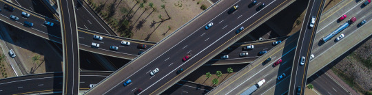
Urban planning and development were made easy with satellite and aerial imagery.
Many cities are currently developing; therefore, there’s a growing demand for up-to-date land topography and land use maps, and other spatial data products. These maps are essential to land use development, natural resource management, and engineering applications.
Many urban site planning projects are based on multi-source remote sensing techniques to ensure the best quality data over broad areas. Mapping applications within urban environments focus on using the latest and least time-consuming approaches to provide the highest product quality at a lower cost.
Satellite and aerial data help with urban planning by regulating and monitoring planning applications, city infrastructure modeling, change detection, carbon footprint analysis, and 3D modeling, including digital city creation. Satellite data offers urban planners a powerful tool in analyzing and understanding the existing urban environment to optimize planning decisions for the development of that environment.
Smart cities require standards that enable data and apps to interoperate easily. An excellent way to begin is to develop a citywide 2D and 3D urban data model to integrate different sources of available geospatial data on the cloudeo Marketplace. The data model becomes the city’s standard, a language that all actors, datasets, and technologies interact with. Consequently, digital twins of cities will evolve, which will allow new levels of understanding and planning of city developments.
0 notes
Text
AVIATION INDUSTRY FLIES HIGHER WITH GEOSPATIAL DATA

Currently, the amount of technological advancement that the world is witnessing is astounding. An essential part of this development is the growth of the drone and the aviation industry. Drones are getting more often used for surveillance, photography, deliveries, etc. As drone applications increase, the drone industry turns to satellite imagery and geospatial data to optimize its planning, operations, maintenance, and security efforts. To the same extent, planning and managing autonomous flights – manned or unmanned- is making huge steps forward.
Drones for Factory Surveillance
More and more industries are relying on drones for factory surveillance. Drones help the factories monitor real-time activities at any time of the day or night while sitting in any corner of the world. The main advantages of using drones instead of traditional factory surveillance methods are their dynamic placement, the bird's eye view that they can provide, and continuous situational awareness. Factory surveillance through drone technology is much more feasible in terms of costs and ease of use.
Drone Taxis
As shown in sci-fi movies, drones have become a reality for transporting people as a private vehicle and a part of a public transport system. Drones have many advantages over heavy-weight airplanes, especially for short distances and, for example, in Urban Air Mobility (UAM), representing a very challenging environment.
The lighter weight of drones makes them more maneuverable in flight and landing. Drone taxis can fly at low altitudes, and with proper maneuvering, they can be easily saved from running into obstacles. Satellite imagery can help in the easy detection of obstacles. With the concept of travel by drone not yet becoming popular, there is no chance of traffic congestion in the airspace currently. Even when the situation changes, satellite data can primarily help in drone traffic management.
With the rise in drone usage, their safe flight planning and management becomes even more critical, and this is where satellite data can play an unmatched role.
Safer Autonomous Flying with remote sensing
A requirement for safe autonomous flying is up-to-date and precise data regarding obstacles and potential landing spots, integrated into flight planning and operations. Digital Surface Models (DSM) with clutter information and high-resolution satellite imagery can be essential sources.
Remote sensing enables drone operators to prepare a flight plan by providing broader information coverage than traditionally surveyed.
Remote sensing can help provide information about building locations and other obstacles that can hamper and endanger drone operations within a particular area. Using LiDAR, you can have highly accurate elevation data, which is critical for drone operations. Multispectral imagery can mainly help in assessing the natural environment around a drone's flight path. Information about trees that can grow to become obstructions, wetlands in potential construction areas, or vegetation that can attract birds are critical for safe drone flight operations. Satellite imagery can aid in getting a good understanding of such information.
Better Management of Air Traffic
Geospatial technology can play an essential role in controlling air traffic. Location data can enable drones to coordinate with each other and avoid collisions. This could aid in the easy rerouting of air traffic as necessary.
The trend of using satellite data for safer drone operations is picking up. For instance, Altitude Angel, the UTM (Unmanned Traffic Management) technology provider, and Inmarsat specializes in global mobile satellite communications, recently collaborated to develop and deliver an advanced flight tracking and management capability for drones.
The two companies intend to build on Altitude Angel's GuardianUTM platform and develop a 'Pop-Up UTM' capability, which can be deployed anywhere required to manage Beyond Visual Line of Sight (BVLOS) operations. Various other companies are working in parallel on similar projects.
Flying Beyond Visual Line of Sight (BVLOS) more safely
Beyond Visual Line of Sight (BVLOS) operation is picking up as a standard requirement in many industrial and mission-critical applications. Unlocking BVLOS operations in autonomous drones is creating new use cases and enhanced performance scenarios in various applications.
Be it disaster management, precision agriculture, law enforcement, or insurance, more and more industries consider BVLOS as the future for managing operations. For instance, the wide-area surveillance capability that BVLOS offers allows insurers to assess losses in disaster-stricken neighborhoods safely and quickly.
However, the deficit of confidence in the safe operation of BVLOS remains a critical hurdle on their path to getting more ubiquitously adopted. In the absence of a pilot's view, these drones face higher risks of collisions and accidents. This is where high-resolution satellite data can help. The drones can gain enhanced situational awareness using accurate satellite imagery, informing them about the obstacles and helping them reroute as and when necessary. High-resolution, up-to-date data leads to improved planning and increased situational awareness during the flight. This simplifies the process of mapping routes and finding appropriate landing spots.
Where to find high-quality Geodata for safe drone operations?
So, there remains no doubt that is using high-quality geospatial data. The drone and aviation industry can achieve a high operational excellence level in planning and managing flight operations. Geospatial data can also significantly aid in air traffic management and BVLOS operations.
However, an important question arises here: 'Where can I get high-quality geospatial data that meets these needs most effectively?'
One answer is cloudeo.
Using cloudeo, you can access multiple high-quality, ready-to-use data from various geodata creators like satellites, airplanes, drones, and in-situ-data under Data as a Service(DaaS) in a few clicks. Additionally, the Software as a Service (SaaS) feature can allow you to use the latest version of different software types needed to process the geodata without worrying about updates, releases, etc. The platform strategically brings together partners and customers into one standard operating platform globally.
This cloud-based market platform hosts a wide range of value-added service providers and developers who can simplify and customize the data as per the user's needs. With Infrastructure as a Service (IaaS) provision, the users can use all cloudeo services without increasing their IT infrastructure cost. The service works excellently with user-specific specifications, code, workflow, and even offers scalable options at a very affordable price at the customer's preferred location and time.
All in all, the platform stands out as the perfect choice for high-valued geoinformation services that the aviation industry is looking at for better operations. By bringing in all the data creators, data processors, and data users into one platform, cloudeo is creating the most user-friendly geospatial solutions marketplace to meet your company's need of accessing highly accurate geospatial data.
Explore cloudeo today and take an essential step towards building a safe drone flying environment.
0 notes
Text
Strengthening Infrastructure Projects with Geospatial Data
With the rapid rise in population and other socio-economic effects, the infrastructure industry is showing unprecedented growth. With this growth comes the increasing push for integrating geospatial context information into infrastructure planning and management. With more and more buildings, roads, and other infrastructure elements getting added to the Earth’s map, they need to understand the geospatial context of infrastructure is becoming all the more necessary.
Geospatial technologies play a significant role in reducing risks and improving the viability of infrastructure projects. Analysis of geospatial data provides additional insight to engineers and architects, helping the stakeholders reduce costs and risk and improve efficiency.
Using spatial information, people from different construction lifecycle sections can create digital models that help create a typical project picture. These shareable models allow improved coordination among the stakeholders.
Drones and high-resolution satellites have revolutionized the process of surveying and mapping construction sites. No matter where you are located, you can easily monitor your construction site’s progress using these data. Drones can capture high-quality data in less time using high-resolution camera payloads and related mapping solutions. Using this data, work progress reports can be prepared with quality images.
What’s more? Drone and high-resolution satellite data can also help the construction project stakeholders create digital surface models, digital terrain models, and 3D models. These models facilitate a more in-depth analysis of the work in progress at the site.
Urban Planning and Geospatial Data
A direct consequence of urbanization is the increase in the number of people living and working in cities and the corresponding infrastructure development. This leads to variations in cities, both spatially and temporally. To develop updated city plans, it becomes necessary for government officials, planners, decision-makers, and researchers to acquire quantifiable records for any city’s spatial growth and temporal change.
Geospatial data can help identify changes in land uses’ geographical features or behavior over a specified time. Such information allows professionals to make more informed decisions related to the development condition of an area. They can then plan accordingly.
Satellite remote sensing data are widely used to study and monitor land features, natural resources, and dynamic effects of human activities on urban areas. A comprehensive base map of the city and adjacent regions indicating physical characteristics may be prepared quickly with satellite imagery. It can be kept current by applying efficient satellite-based change detection. Geospatial data also plays a vital role in resource management, environment monitoring, land use, and planning activities. Remote Sensing provides reliable, timely, accurate, and periodic data, which helps create different planning scenarios for efficient decision making. Geospatial technologies provide the required input and intelligence to prepare base-maps, make planning proposals, and act as a monitoring tool during the implementation phase of any urban planning scheme.
Geospatial data can significantly help to elaborate suitability for constructing specific construction such as bridges or dams. Feasibility studies of smaller structures like schools and hospitals can also be carried out effectively using location intelligence. It can also be used to ascertain the feasibility of an area for waste disposal and treatment. The application areas remain unlimited.
Sustainable Cities and Geospatial Data
The world is moving towards the development of smart cities. These cities seek to provide a better living experience to the residents and fostering sustainable development. Sustainability remains a crucial goal of smart cities, and intelligent and green infrastructure automatically becomes the need of the hour.
All this requires efficient planning and geospatial data is a crucial component of the planning process. The cities’ digital twins can be created, leading to more effective city architectures using cloud data.
For instance, the Moscow government used a blend of publicly available cloud data and privately collected and refined data from drones and data collection vehicles driving through Moscow streets for a digital twin creation. 3D visualization of Moscow’s whole powered by UNIGINE 2 became a very accurate representation of the city geometry and different layers like traffic, energy, and economic factors.
Transport Infrastructure and Geospatial Data
Robust transport infrastructure is a mandatory requirement of a sustainable city. Transport Infrastructure is of critical importance to a country’s economic growth. With a rise in people and goods’ movement each passing day, there is a need to create a sustainable and resilient transport network. When it comes to creating a robust railway or road network, geospatial data plays a vital role. This is why Innovate UK selected Hexagon’s Geospatial division to conduct a research project that could lead to faster and higher-precision mapping of its railway infrastructure. The project was expected to enable Network Rail to automatically identify and measure railway structures from LiDAR data, saving valuable time and resources while also improving planning and operations across the rail network.
More Resilient infrastructure with Geospatial Data
An Infrastructure that is durable, resilient, and can withstand disasters are necessary components of future cities. Geospatial technologies offer solutions that are safe, sustainable, and environment friendly. With the escalating threats of natural disasters, it is becoming essential to invest in the right infrastructure of the best quality.
For instance, consider the ‘Room for the River’ initiative of the Netherlands. Nearly 30% of the Netherlands is below sea level, and another 30% is vulnerable to flooding along its rivers. This initiative involves making room for rivers in 30 locations by creating space for floodwaters, creating diversions for excess, and restoring riverine landscapes. Also, in Iowa, climate change information is being used to assist in urban planning and infrastructure design. Satellite data primarily helps in bringing such goals to fruition.
Monitoring Illegal Construction using Geospatial Data
Governments and municipalities need tools to detect illegal construction activity early, and this is another area where satellite data can help them effectively. Satellite data allows continuous monitoring of changes within an urban environment. Governments can quickly identify new constructions and demolitions in an area by frequently monitoring sites with satellite data. This data helps them identify encroachments and other illegal constructions rapidly, and thus timely actions can be taken.
Cloud-based Geospatial Analytics
Geospatial data gathered in construction are usually of large spatial scales. Storage, processing, and analysis of these data often become a challenging task. This is where cloud computing platforms having access to large cloud providers provide much-needed help to the infrastructure industry. One such platform is Cloudeo.
Cloudeo is the platform that enables infrastructure companies to access multiple high-quality, ready-to-use data from various geodata creators like satellites, airplanes, and drones, in-situ-data, etc. under Data as a Service (DaaS) in a few clicks. Additionally, the Software as a Service (SaaS) feature allows the customers to use the latest version of different software types needed to process the geodata without worrying about updates, releases, etc. The platform strategically brings together partners and customers into one standard operating platform globally.
This cloud-based market platform hosts a wide range of value-added service providers and developers who can simplify and customize the data as per the user’s needs. With Infrastructure as a Service (IaaS) provision, the users can use all of Cloudeo’s services without increasing their IT infrastructure cost. The service works excellently with user-specific specifications, code, workflow, and even has to scale up options at a very affordable price at the customer’s preferred location and time.
All in all, the platform stands out as the perfect choice for high-valued geoinformation services that infrastructure companies are looking at, more actively now with the promise of 5G in place. By bringing in all the data creators, data processors, and data users into one platform, Cloudeo is creating the most user-friendly geospatial solutions marketplace to meet your company’s need to access highly accurate geospatial data. For instance, whether you are planning an infrastructure network, conducting a military intervention mission in unknown terrains, or analyzing terrain features for oil and gas exploration: accurate terrain height information is critical. For example, Airbus' Elevation 1 & 4, accessible through the Cloudeo platform, provides highly precise elevation information anywhere in the world, independent of relief and weather conditions, on-demand for your area of interest. Numerous other options are waiting to be explored on the platform. Explore Cloudeo today and take the first step towards creating smarter cities of tomorrow.
0 notes
Text
How to meet researchers constant need of high-quality geospatial data
By bringing together maps, apps, data, and people, geospatial information allows everyone to make more informed decisions. By linking science with action, geospatial information enables institutes, universities, researchers, governments, industries, NGOs, and companies worldwide to innovate in planning and analysis, operations, field data collection, asset management, public engagement, simulations, and much more.
By bringing together maps, apps, data, and people, geospatial information allows everyone to make more informed decisions. By linking science with action, geospatial information enables institutes, universities, researchers, governments, industries, NGOs, and companies worldwide to innovate in planning and analysis, operations, field data collection, asset management, public engagement, simulations, and much more.
Areas of Engagement
Researchers use spatial information to trace urban growth patterns, access to mobility and transportation networks, analyze the impact of climate change on human settlements, and more. When spatial datasets are linked with non-spatial data, they become even more useful for developing applications that can make a difference. For instance, geospatial data coupled with land administration and tenure data can significantly impact urban planning and development by the landowners.
For example, a recent project by the Government of India, 'The Swamitva Project,' uses geospatial data to provide an integrated property validation solution for rural India. 'Swamitva,' which stands for Survey of Villages and Mapping with Improvised Technology in Village Areas, uses Drone Surveying technology and Continuously Operating Reference Station (CORS) technology for mapping the villages. The project aims to provide the 'record of rights' to village household owners, possessing houses in inhabited rural areas in towns, which would enable them to use their property as a financial asset for taking loans and other financial benefits from banks. The project stands to empower the rural peoples of India
Geospatial is also playing a crucial role in disaster management. By deploying geospatial data for all disaster management phases, including prevention, mitigation, preparedness, vulnerability reduction, response, and relief, significant disaster risk reduction and management can be achieved.
We all are aware that when a hail storm strikes, the damage can be catastrophic. In fact, with damage totals sometimes exceeding USD 1 billion, hailstorms are the costliest severe storm hazard for the insurance industry, making reliable, long-term data necessary to estimate insured damages and assess extreme loss risks.
That's why a team of NASA scientists is currently working with international partners to use satellite data to detect hailstorms, hail damage, and predict patterns in hail frequency. This project will provide long-term regional- to global-scale maps of severe storm occurrence, catastrophe models, and new methods to improve these storms' short-term forecasting.
"We're using data from many satellite sensors to dig in and understand when and where hailstorms are likely to occur and the widespread damage that they can cause," shares Kristopher Bedka, principal investigator at NASA's Langley Research Center in Hampton, Virginia. "This is a first-of-its-kind project, and we're beginning to show how useful this satellite data can be to the reinsurance industry, forecasters, researchers, and many other stakeholders."
Climate change is another area where research based on geospatial data is of extreme importance. The geospatial analysis not only provides visual proof of the harsh weather conditions, melting polar ice caps, dying corals, and vanishing islands, but also links all kinds of physical, biological, and socioeconomic data in a way that helps us understand what was, what is, and what could be. For instance, air quality is a public health issue that requires ongoing monitoring. Not only does air quality data provide information that can protect residents, but it also helps to monitor the overall safety of a geographic area. NASA uses satellites to collect air quality data on an ongoing basis. The satellites can evaluate air quality conditions near real-time and observe different layers and effects that may coincide.
Satellite data can reveal information like the aerosol index and aerosol depth (which indicates the extent to which aerosols are absorbing light and affecting visibility) in any given area. Other types of data that satellites collect include levels of carbon monoxide, nitrous oxide, nitric acid, sulphur dioxide, fires, and dust.
Near real-time data helps to warn residents of low air quality. It can also be used to determine how climate change impacts a geographic area and guides new infrastructure design with climate change in mind.
Thus, there is hardly any living area where geospatial data or location intelligence cannot significantly impact. The more one engages in geospatial research, the more fascinating the journey of discovery becomes.
COVID-19 and Geospatial Research
The current pandemic has made each one of us realize the importance of geospatial data all the more. Be it identifying the hotspots, taking corrective measures sooner, and curbing the spread of the virus. Geospatial research has enabled the authorities to make headway more effectively in all spheres.
The location has been the answer to most of the problems. Thus more and more companies are now engaging in the development of apps that can help trace the virus and help businesses and individuals recover faster. Accordingly, researchers are increasingly engaging in projects that could bring such significant geospatial products to life soon.
Research bottlenecks due to COVID
Projects that aim to harness location intelligence's power have high-end hardware, software, and data requirements. Researchers typically have a high-end infrastructure at their disposal. These systems are placed either in their workplace or the universities where they are pursuing their research projects. These research hubs are also their gateway to highly accurate geospatial data. In regular times, they do not need to look anywhere else. However, the scenario is completely changed due to the pandemic. With the universities remaining closed for a long time, researchers are more dependent on the online availability of good quality infrastructure and data. As a result, platforms providing Data as a Service (DaaS), Software as a Service (SaaS), Infrastructure as a Service (IaaS) solutions are becoming popular among the research community.
Meeting hardware requirements
Lockdown and closure of educational institutions have brought researchers face-to-face with the lack of high-end infrastructure required for processing geospatial data. In such a scenario, researchers rely more and more on platforms that can provide the convenience of Infrastructure as a Service (IaaS).
Hardware is becoming less and less essential in the age of cloud computing. Cloudeo's Infrastructure as a Service (IaaS) solutions can help the researchers streamline their hardware requirements, save costs, and increase their research work efficiency. With Cloudeo's Infrastructure as a Service, a researcher needs to pay only for what they need. This helps in minimizing investment in local infrastructure. They can also quickly and dynamically adapt the processing power or storage they need, spreading big processing jobs over many cores. This is something that they might not accomplish (or afford) with their physical hardware. Also, while using this service, all the data gets backed up securely in the cloud and remains protected from unexpected critical hardware failures.
Meeting geospatial data requirements
Researchers need access to platforms that can provide high-quality geospatial data from multiple sources at a low cost. Cloudeo's DaaS is emerging as an increasingly popular solution among the researchers for accessing highly valuable data from various sources, like suppliers of spaceborne, airborne, and UAV imagery and data. It's a cost-effective solution as the users do not have to buy permanent licenses for EO data integration, management, storage, and analytics. Data as a service is especially advantageous for short-term projects, where long-term or permanent licenses and data purchases can become cost-prohibitive.
Over the past few years, more and more Earth Observation (EO) data, software applications, and IT services have become available from an increasing number of EO exploitation platform providers – funded by the European Commission, ESA, other public agencies, and private investment.
For instance, ESA's Network of Resources (NoR) supports users in procuring services and outsourcing requirements while increasing uptake of EO data and information for broader scientific, social, and economic purposes. The goal is to support the next generation of commercial applications and services.
Cloudeo acts as the NoR Operator, together with its consortium partners RHEA Group and BHO Legal, by managing service providers' onboarding into the NoR Portal. The portal is a compilation of the NoR Service Portfolio, listing services on the NoR Portal, promoting the NoR services worldwide, and procuring such services for commercial users and ESA sponsorship.
Through NoR, cloudeo plays a vital role in improving and supporting education, research, and science. It is promoting community building by enabling collaboration between all stakeholders.
Research is crucial for the growth of an economy. As businesses mostly realize the importance of integrating geospatial with everyday affairs, research in the field of geospatial is gaining momentum. Accordingly, the need for access to high-quality geospatial data is also increasing. While most universities are equipped to meet these researchers' needs in regular times, with the current lockdowns and closure of institutions, the researchers are relying on robust, accurate online platforms that can meet their hardware, software, and geospatial data requirements. Cloudeo is one such reliable platform for accessing geospatial data from disparate sources. It can also complete the infrastructure requirements of researchers effectively. By bringing in all the data creators, data processors, and data users and solution/app developers onto one platform, cloudeo is creating the most user-friendly geospatial solutions marketplace to meet the infrastructure, software, and data needs of researchers.
Explore cloudeo today and take an essential step towards excelling in your research and academic endeavors. No one can tell you about everything spatial so accurately!
0 notes
Text
How the telecommunication industry is getting reshaped with geo-spatial technologies
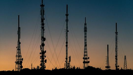
Telecommunication is a highly competitive industry and a major factor that has enabled the leaders to gain a competitive edge is their decision to factor in the power of location intelligence in their functioning at an early stage. Location intelligence has been helping them to understand vital facts about their business such as how many customers they can reach, how many towers they need to build and connect, how they can optimize the existing networks, etc. By keeping the ‘where’ dimension in their functioning, these companies have been able to model and test the best sites to locate towers for optimum coverage, understand the demographics of the population, and target outreach efforts.
Telecommunication is a highly competitive industry and a major factor that has enabled the leaders to gain a competitive edge is their decision to factor in the power of location intelligence in their functioning at an early stage. Location intelligence has been helping them to understand vital facts about their business such as how many customers they can reach, how many towers they need to build and connect, how they can optimize the existing networks, etc. By keeping the ‘where’ dimension in their functioning, these companies have been able to model and test the best sites to locate towers for optimum coverage, understand the demographics of the population, and target outreach efforts.
Geo-spatial has been an integral part of telecom networks so far, but with 5G in the picture, the relevance of geodata in telecommunication increases manifold.
Why Geo-spatial is Crucial in Telecom’s sustainable development
Optimizing telecom networks is not just about rolling out new technologies like 5G. The telecom companies need to focus on analyzing and optimizing the existing networks as well, and this cannot be achieved without the effective use of geospatial data. Using new location data streams, they can understand consumers at a deeper granularity. Be it long-term network planning, developing the marketing strategy or capability building, geospatial becomes their ‘go-to’ technology as well.
With more complex 5G networks, the necessity of having accurate and detailed geospatial data will heighten. Location technology is vital for telecom network planning, risk management, and performance monitoring, and with 5G the importance will intensify.
5G is a wireless technology standard that promises to bring with it enhanced capacity and speed of data transmissions, often referred to as low latency. This is required to enable communication between millions of devices, sensors, and infrastructure. This split-second flow of densely packed data will allow intelligent systems to make more informed decisions while managing daily operations of smart communities.
5G will serve as the data transmission backbone of future technologies and cities, and to make the technology a success, telecom operators have to necessarily integrate spatial data and big data into their operations. So is the case with existing networks (2G, 3G, 4G/LTE) which aim to upgrade themselves and provide better services.
Geospatial data in all realms
Low-latency data throughput, which must be achieved by 5G to fulfill its promises of high-speed connectivity and data transmission, requires it to operate in a very broad bandwidth of the radio-frequency (RF) spectrum with a much higher frequency. Accordingly, cellular networks need to be reconfigured into much smaller, tighter cell sites, and as compared to 4G networks, operators are required to install many more cell sites per square kilometer. For such precise planning of installation sites, using location intelligence becomes necessary.
Next, to have undisturbed high-speed data transmission and network availability, it is necessary to ensure that 5G signal paths do not get obstructed by objects such as buildings and trees. For ensuring this, highly accurate geodata is required. Accurate maps that display terrain and infrastructure can help the telecom operators to determine where the towers can be built such that they can relay high-frequency signals effectively.
Managing Risks and Assets
Location intelligence and access to highly accurate geospatial data can help the telecom operators to not only carry out effective network planning but also manage the assets after installation. Accurate identification of problem sites will help the teams to resolve the issues quickly. This quick and efficient resolution of issues will lead to enhanced customer satisfaction.
Using visual mapping dashboards and automated alerts triggered from the GIS system based on geofencing or risk proximity, Network Operating Centers can get a clear overview of physical and human assets and proactively monitor the risks that could threaten the network operations. Risks could be environmental such as hurricanes, earthquakes, and storms as well as those related to health and safety.
Timely identification of the risks will allow the organizations to take the necessary action faster and add more satisfied customers to the database.
Improving Workforce Management
There remains no doubt that due to the presence of more advanced capabilities, 5G networks and infrastructure will be more complex than the 3G and 4G networks. Accordingly, there will be an increase in the number of assets (towers, microcells) as well. The increased number of assets will require more installation and maintenance work, putting more pressure on the field service workforce.
In such high-pressure situations, geospatial technology will enable the workforce to be more efficient. Geospatial technology will help in improving and automating several aspects of the workflow management; right from route planning optimization to dispatch and vehicle tracking, to monitoring real-time outage intervention status. The outcomes so achieved will be par excellence.
Enhancing Customer Experience
Right from the planning stage, geospatial data will significantly help the telecom operators identify the best markets to develop. Based on data related to population density or population segmentation expenditures, the operators can identify the best areas for potential 5G consumers. Demographic data can also help them to ascertain where the towers should be installed as it would be better to keep them closer to areas where the maximum number of customers will be located.
An important component of good customer service is the easy availability of a physical store. It is necessary for the telecom providers to place the stores strategically to be able to cater to the existing and new customers better. This is another area where geospatial data has been playing a vital role. It has been helping the telecommunication companies in identifying the best location for their stores and with 5G the story will be no different.
In today’s digital world, even before a customer arrives at a physical store, he/she researches the carrier, its coverage quality, or availability of the service in their geographic area through the company website. For providing such information accurately to the prospective customers, telecom companies have to harness the power of location technology, be it for geocoding the customer location, validating service availability, or allowing them to select the nearest store-based on preferred criteria. This practice has been adopted by the leaders in the fields and with competition enhancing, the 5G players definitely need to imbibe the same.
Telecom companies must work towards including highly accurate coverage maps in their websites which can help the prospective customers to know when the 5G technology will be available near them. Easy availability of such information will help in building up the customer base. Moreover, analysis of such queries can largely enable the telecom provider to decide where to invest while building up the network such that it can cater to a larger number of customers.
After the service is in place, geospatial data will also be beneficial for resolving customer complaints. It can be used to perform pre-diagnostic tests by locating potential causes, whether it’s a weak coverage close to a customer location, an ongoing outage in proximity to a customer, or a cell site that reaches maximum capacity. Such location-based analysis can greatly speed up the resolution time and improve customer satisfaction while making the telecom provider more efficient.
Where to Find High-Quality Geodata
So, there is no doubt that using geospatial data, telecom companies can aim towards creating more robust networks and achieving the goals of very high data speeds, low latency, enhanced reliability, huge network capacity, and better user experience to the increased numbers of users.
However, an important question arises here, ‘Where to get high-quality geospatial data that meets the needs effectively?’
One answer is Cloudeo.
Cloudeo is the platform that enables Telecom companies to access multiple high-quality, ready-to-use data from various geodata creators like satellites, airplanes, and drones, in-situ-data, etc. under Data as a Service (DaaS) in a few clicks. Additionally, the Software as a Service (SaaS) feature allows the customers to use the latest version of different types of software needed to process the geodata without worrying about updates, releases, etc. The platform strategically brings together Partners and customers into one standard operating platform globally.
This cloud-based market platform hosts a wide range of value-added service providers and developers who can simplify and customize the data as per the user’s needs. With Infrastructure as a Service (IaaS) provision, the users can use all of Cloudeo’s services without increasing their IT infrastructure cost. The service works excellently with user-specific specifications, code, workflow, and even has to scale up options at a very affordable cost at the customer’s preferred location and time.
All in all, the platform stands out as the perfect choice for high-valued geoinformation services that telecom companies are looking at, more actively now with the promise of 5G in place. By bringing in all the data creators, data processors, and data users into one platform, Cloudeo is creating the most user-friendly geospatial solutions marketplace to meet your company’s need of accessing highly accurate geospatial data.
Explore Cloudeo today and take the first step towards creating more robust networks that will power the smarter cities of tomorrow.
0 notes
Text
VegetationVitality promotes crop optimization | cloudeo

The farms of Southern Italy experience a particularly long Mediterranean growing season. The chief harvested crops of the fertile but seismically active Campania region are fruits, wine, tobacco, and flowers.
The agriculture industry is a pillar of the Campania economy. Here, the average farm is only 4 hectares in size but nevertheless highly productive. For larger farms, it can be challenging to measure how much and where more water is needed for optimal plant growth, even if they appear green in satellite imagery. Regardless of farm size, however, achieving optimal plant health is vital to a bountiful harvest.
VegetationVitality uses scientifically validated and industry-accepted methods to deliver insightful information on the health of vegetation.
Analysis performed on the image reveals much more than a picture. Using light waves, NDVI, or normalized difference vegetation index, measures chlorophyll levels in leaves. When chlorophyll levels are at their maximum, plants are growing healthy and strong.
The darker green areas have the highest NDVI, indicating the healthiest plants. Tan and red areas either contain weaker plants, bare soil, or human settlements.
In this case, clouds in the water and snow on the mountain tops also appear red.
Powered by Harris Geospatial Services Framework (GSF) and HySpeed Computing, VegetationVitality also provides detailed analytical reports on the area of interest (AOI). The included report shows that in the Campania region, over 7000 sq. km is vegetated, but only 1000 sq. km are plants with high vitality at this time. On a farm, the light green areas could probably use more water, whereas the tan areas could be ready for planting.
The scale is adjustable to any AOI. Including the aforementioned NDVI index, there are a total of 6 different vegetation indices available to choose from – each offering advantages and insights to the health and condition of plants based on vegetation type and environmental conditions.
The Non-Linear Index (NLI), for example, is another Vegetation Vitality index available which provides amplified discrimination between healthy crops and other land-use types. Fields are clearly delineated in green, while infrastructure and bare fields are in red. In the following exemplary, a zoomed-in snapshot of the coastline with NLI shows us that not only is the area not very densely vegetated but well populated.
Your Vegetation Vitality data package comes delivered with images and shapefiles ready for immediate use or further analysis, as well as an easy to read PDF report which breaks down the results into helpful summaries, complete with graphs and legends. Orders start from 10€.
Click here to buy the product
Vegetation Vitality Benefits
Low cost and fast delivery
Current and past images
Subscribe on a time basis
Tailored results to your needs
No processing image yourself
No expensive software licenses
0 notes
Text
Environmental issues of the Three Georges Dam
Three Gorges Dam, the dam on the River Yangtze (Chang Jiang) just west of Yichang City in Hubei Province, China. Once the dam was formally started building in 1994, it was China's biggest engineering project. This was the world's largest dam structure at the time its completion in 2006.
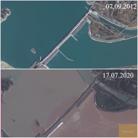
The High-resolution satellite imagery was captured by ShowMySite from cloudeo. ShowMySite used to get a literal “high-level overview” of any plot of land (for example, to monitor long-term and short-term changes from construction, infrastructure, or natural terrain changes)
Landslides
Erosion in the reservoir caused by rising water causes frequent major landslides that resulted in noticeable disturbances in the surface of the reservoir, including two incidents in May 2009 when somewhere between 20,000 and 50,000 cubic meters (26,000 and 65,000 cubic meters) of material plunged into the Wuxia Gorge of the Wu River.
Sedimentation
Two hazards that are unique to the dam are listed. One is that there is no consensus on sedimentation estimates and the other is that the dam sits on a seismic fault. At current levels, 80 percent of the area's land is undergoing erosion, depositing about 40 million tons of sediment annually into the Yangtze. Since the flow above the dam is slower, more of this water will now settle down there instead of going downstream, and there will be less downstream runoff.
Soil Erosion
Hydrological experts had cautioned that the dam was unsafe for the ecosystem due to several factors. Two dangers associated with the dam were the inviolable predictions of sedimentation and the seismic fault on which the dam sits. 80% of the land in the dam region experienced soil erosion, depositing about 40 million tons of sediment annually in the Yangtze River.

Erosion in the reservoir, induced by rising water, caused frequent major landslides which resulted in visible disruption in the surface of the reservoir.
The dam has also affected the forest cover, wildlife, and terrestrial impact and its waste management is also under a cloud.
Fact about Three Gorges dam
Three Gorges Dam was built, 39 trillion kilograms of water from the Yangtze River built up behind it to 175 meters above sea level. NASA has estimated that the dam only delays 0.06 microseconds, which is six-hundredths of a millionth of a second, in rotation. The rotational speed of our planet actually fluctuates fairly frequently, as it can be influenced by the North Pole 's earthquakes, the moon, and climate change-induced movement.
Regional rainstorms and mudslides that started up have uprooted over 7,300 houses and affected nearly eight million people by the end of the month. The intense non-stop rains had increased the fears of the public about the possible harm to the world's largest hydropower project.
To get High-resolution Satellite Imagery: https://www.cloudeo.group/showmysite
0 notes
Text
Highlight the risk in real estate with Digital Elevation Model Data

NEXTMap One is available as a DSM (digital surface model) or DTM (digital terrain model). With a DSM, it is also possible to see buildings and trees, whereas, with a DTM, just the bare earth surface is presented. A DSM might be particularly useful for visualizing hazards down to the individual building level. A DTM might be more useful for slope and soil removal calculations.
The location of new real estate comes with inherent uncertainties: what environmental hazards could affect this site? Before you build, consider the often-overlooked factor of elevation.
Logistics of new real estate
In real estate development, before you select a site for a new building, many aspects must be considered prior to the construction phase.
Logistics within real estate is not a new concept, however, new technologies are taking it to the next level. High powered modeling software and precision data are allowing the industry to plan ahead and better identify potential problems before they happen. An example of this is the integration of environmental factors into the planning process.
One of the most commonly overlooked aspects before investing is mitigating environmental uncertainties on the site, many of which can be attributed to elevation. The elevation is an important indicator for many costly hazards associated with a specific location of interest, such as landslides, flooding, sea-level rise, and accessibility.
The elevation is used not only to identify hazards but also to estimate how much preparation will be necessary on a landscape for new construction, including grading and calculating how much soil needs to be removed or added. Costs can be estimated ahead of time and better budgeted even before the first survey occurs.
NEXTMap One is a high-resolution elevation dataset designed for precision analysis. It is one of the most accurate digital elevation models (DEMs) on the market, with up to 1-meter (3.24ft) resolution, now available as a subscription service exclusively from cloudeo.
With NEXTMap One as a Service, you can quickly analyze your area of interest to determine the feasibility of a new site before you build to minimize the uncertainty of future issues. Quick analysis in GIS software can reveal more than meets the eye.
Landslides
The slope is an important component in calculating the chance of landslides. Although it is not the only factor, it can be an important indicator especially if homes are built on a steep slope or on the top of a hill close to the slope edge.
Slope information can easily be derived with the industry-leading NEXTMap One as a Service elevation data in most free and commercial GIS Mapping software.
Flood Assessment
Elevation data can be used to evaluate the risk of flooding. If an area is within close proximity to a river, in a floodplain, or has previously experienced flash-floods, elevation can reveal how much water the property would be subjected to in a flooding event.
Find the lowest elevations nearby a river or run hydrology analysis in professional GIS analysis programs on the NEXTMap One elevation data.
Sea level rise
Coastal properties face the risk of rising sea levels. How close to the water should a waterfront property be if there are just a few inches of sea-level rise? How does that affect the property value long-term?
Use the NEXTMap One data in gis software to estimate where the new coastline would be with a loss of coastline due to a rise in sea level.
Accessibility
During the construction phase, how will the materials be brought to the site? Are roads and infrastructure good enough for large trucks to bring the materials? If flooding or a landslide were to occur, how would that affect access to the site?
Overlay infrastructure data with NEXTMap data in GIS software. Identify where roads run along with landslide-prone steep areas or if roads at low elevation near your area of interest are at risk of flooding.
Case in point: seasonal flooding
Along the Mississippi river exists seasonal flooding due to spring rains. This year, it is currently experiencing the highest amount of flooding since record-keeping began in the 1800s. The river is nearly 23 feet (7 meters) deep, about 8 feet (2.5 meters) above flood level. (USA Today)
Here is the NEXTMap One elevation map, or digital surface model (DSM), over Davenport, Iowa, a town of about 100,000 people.
Green areas in the image are lower elevation and red areas are higher elevation.
Infrastructure Data
With free TIGER files road data overlayed on top of the DSM, it is possible to see the roads and the elevation information together. Roads that are over the dark green areas are built at low elevations, while roads over lighter areas are built over higher elevations. (US Census Bureau)
Low Elevation Areas Highlighted
Using the DSM, which includes buildings and infrastructure, it is possible to see exactly which structures will be affected if the river rises to a specific level, in this case about 14 feet (4.2 meters) above the normal water level. This analysis is possible because of the high resolution of the elevation data.
Even the pedestrian and cycling bridge in the middle of the frame could be affected by a flood this high.
heck, your potential construction site or new real estate investment with NEXTMap One before you build to reduce the risk of damages from flooding, landslide, sea-level rise, or accessibility.
The NEXTMap One dataset is the industry-leading 1-meter resolution (3.28ft) elevation data set built with 2016 or newer satellite data, so you know you are getting the most up to date information available. It is 6 times more precise than free data and is more affordable than other commercial options, making it the best bang for your buck.
The seamless data set offers coverage free from blunders, seam lines, or spikes that can be visible in other datasets.
With availability over the whole USA and Germany, you can get the coverage you need for your project. Water bodies and coastlines are flattened and corrected for accurate measurement. And NEXTMap One operates natively with all of your other data or programs since it's compliant with the OGC data standards.
NEXTMap One is available as a DSM (digital surface model) or DTM (digital terrain model). With a DSM, it is also possible to see buildings and trees, whereas, with a DTM, just the bare earth surface is presented. A DSM might be particularly useful for visualizing hazards down to the individual building level. A DTM might be more useful for slope and soil removal calculations.
0 notes
Link
https://www.cloudeo.group/
1 note
·
View note