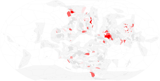
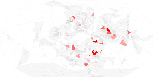
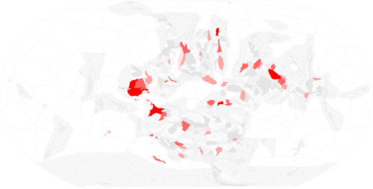
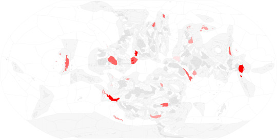
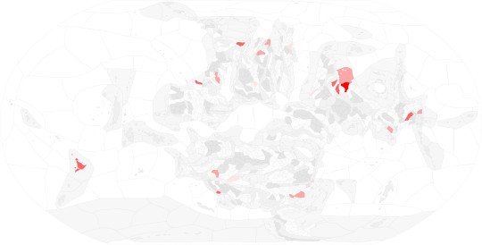
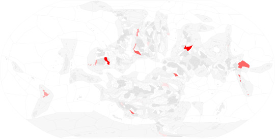
#gis
Photo
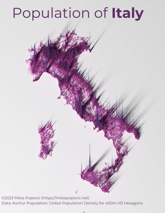
Italy population density.
by @milos_agathon
143 notes
·
View notes
Text
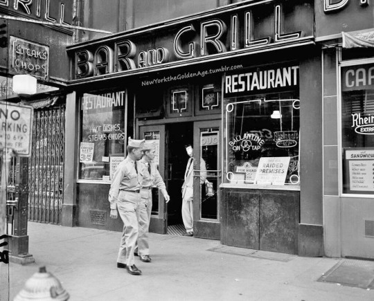
A couple of GIs pass by a restaurant and bar in Times Square with a sign in the window reading. "This is a raided premises," September 24, 1954. The police department was carrying out planned raids in this area, where servicemen mingle with other visitors.
Photo: Carl Nesensohn for the AP
#vintage New York#1950s#vice raid#raid#soldiers#GIs#vice squad#Sept. 24#September 24#24 September#24 Sept.#vintage Times Square
58 notes
·
View notes
Text
Jey Uso (Body 2)


42 notes
·
View notes
Text


What a delectable little pet.
#owlbear cub#owlbear#astarion#oc: nerissa#bhaal babe#my oc#tiefling#the dark urge#durge#bg3 durge#sorcerer#draconic bloodline#baldur's gate 3#bg3#draco plays bg3#gis#gif set
29 notes
·
View notes
Text
COMPLETE AUDIT OF MATERIALS IN FANTASY WORLD
BASEMAP

ROCK TYPE
REGIONS
METALS
IRON - 1
GOLD - 2
COPPER - 3
SILVER - 4
LEAD - 5

MIXED - 6 (Combination of Silver and Gold)

COBALT - 7
TUNGSTEN - 8
ALUMINUM - 9

SILICON - 10 (Combination of Copper, Iron, and Aluminum)

PEWTER - 11 (Combination of Iron and Lead)

CRYOGEN - 12 (Combination of Silver and Lead)

(Gems and Energy will be in the form of reblogs since tumblr only lets me add thirty images to a post)
59 notes
·
View notes
Text


Amygdala
Website / Steam
30 notes
·
View notes

Text
New #GIS drinking game - Every time Q/Arc crashes, you take a shot! It's like Russian roulette for your liver with every click!
24 notes
·
View notes
Text
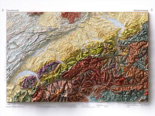
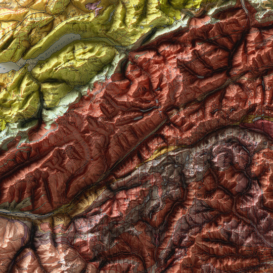
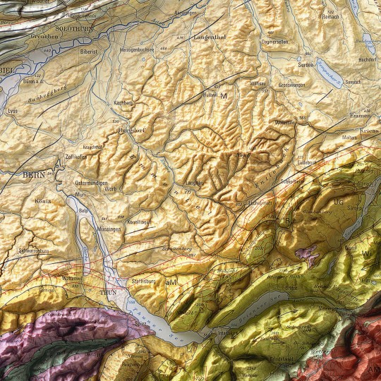
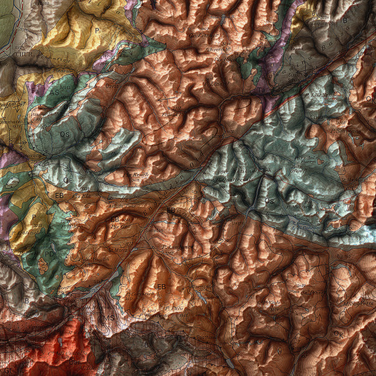
As announced, a new map has been added to the European collection.
We had started this paper years ago, but it had never been finalized. Since we didn't even have a dedicated map of Switzerland yet, we thought it was appropriate to remediate!
This is a geotectonic map of Switzerland that among the authors also has Imhof. It was realized in 1972 but published in 1978 inside the Atlas of Switzerland.
You can find the original sheet in the David Rumsey Map Collection.
If you like our work, want to see our daily updates (or want to say hello to our studio), consider to follow our Instagram or Twitter account. Otherwise if are interested in our prints or have a custom request check our shop.
#switzerlandnature#switzerland🇨🇭#switzerlandtour#switzerlandmylove#switzerlandvacations#berna#ticino#ticinoturismo#geneva#ginevra#geotettonica#geotectonic#geologia#geologist#MapCenter#designmap#shadedreliefmap#shadedrelief#gis#blenderart#blenderartist#cartography#imhof#imhoff#digitaldesign#digitaldesigner
8 notes
·
View notes
Text


Gisele for Pop Magazine SS24 Issue 50
Shot in Miami by Sean + Seng
#gis#gisele bundchen#gisele bündchen#supermodel#beauty#ed#fashion editorial#fashion photography#editorial#fashion#photography#ss24#sean + seng#pop m#pop magazine#Miami
5 notes
·
View notes
Text

✨ NEW EPISODE ✨
In this episode, Dr. Marijke Stoll shares her recent research incorporating both qualitative and quantitative analysis to reimagine the use of GIS in mapping modern and ancient pathways in Oaxaca. We talk about insights gleaned from interviews carried out on the trail, creative ways of using new technology, and bringing the human element into all aspects of our research. Marijke Stoll received her PhD of Anthropology from the University of Arizona in 2018. She is currently a postdoctoral research fellow with the National Science Foundation and is based out of Indiana University-Bloomington.
16 notes
·
View notes
Text
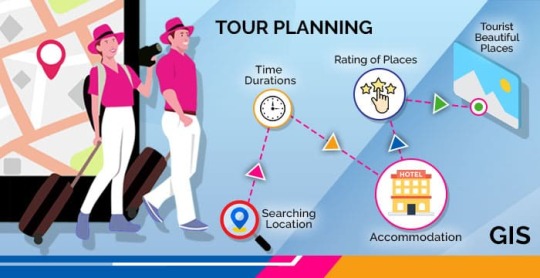
GIS In Our Daily Lives
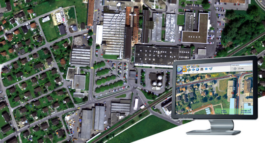
The involvement of Geographic Information Systems (GIS) in our daily lives is pervasive, influencing and enhancing various aspects across different sectors. The integration of GIS into everyday activities has become integral for decision-making, planning, and optimizing resources. GIS helps city planners and transportation experts to provide them with information like maps, satellite pictures, population statistics, and infrastructure data. GIS helps them make better decisions when designing cities and transportation systems that are sustainable and good for the environment.
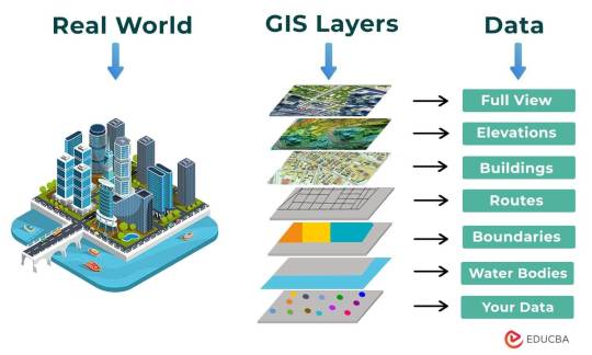
The following points elucidate the notable involvement of GIS in our daily lives:
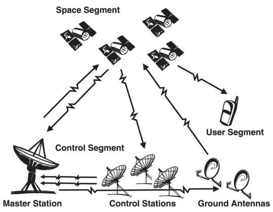
Navigation and Location Services: GIS provides monitoring functions through the visual display of spatial data and precise geographical positioning of monitored vehicles, whereas GPS provides accurate, clear, and precise information on the position and navigation of a monitored or tracked vehicle in real-time and at the exact location.GIS is at the core of navigation applications and location-based services on smartphones. It enables accurate mapping, real-time navigation, and geolocation services, assisting individuals in finding locations, planning routes, and navigating unfamiliar areas.
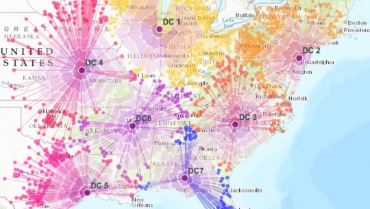
E-Commerce and Delivery Services: GIS software is a powerful tool for supply chain network planning. It helps determine the optimal location for distribution centers, warehouses, or other supply facilities. GIS is utilized in logistics and delivery services for optimizing routes, tracking shipments, and ensuring timely deliveries. E-commerce platforms leverage GIS to enhance the efficiency of their supply chain and last-mile delivery processes.
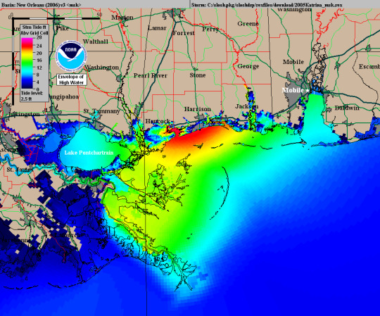
Weather Forecasting and Disaster Management: Many states are using GIS dashboard to monitor the rainfall across the state, on a real-time basis, from the data shared by rain sensors installed at various locationsGIS plays a crucial role in weather forecasting and disaster management. It assists meteorologists in analyzing spatial data, predicting weather patterns, and facilitating timely responses to natural disasters by mapping affected areas and coordinating emergency services.
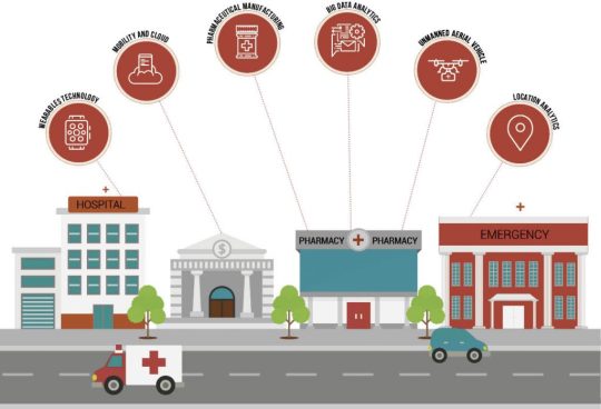
Healthcare Planning and Disease Monitoring: Geographic Information Systems enable the visualization and monitoring of infectious diseases. Additionally GIS records and displays the necessary information that health care needs of the community as well as the available resources and materials. GIS supports public health initiatives by mapping the spread of diseases, analyzing healthcare resource distribution, and assisting in the planning of vaccination campaigns. It aids in identifying high-risk areas and optimizing healthcare service delivery.
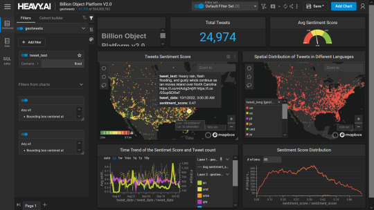
Social Media and Geo-tagging: GIS also helps in geotagging and other location related information in posts, it’s tools can map and visualize the spatial distribution of social media activity. This analysis can reveal trends, hotspots, and patterns in user engagement across different geographic areas. Many social media platforms incorporate GIS for geo-tagging, allowing users to share their location and experiences. This feature enhances social connectivity and facilitates the sharing of location-specific information.
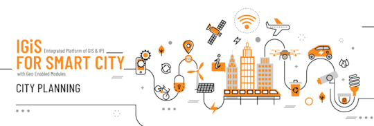
Smart City Initiatives: The Geographic Information System (GIS) offers advanced and user-friendly capabilities for Smart City projects and allows to capture, store and manipulate, analyze and visualize spatially referenced data. It is used for spatial analysis and modeling. It is the cornerstone of smart city planning, enabling the integration of data for efficient urban management. It supports initiatives related to traffic management, waste disposal, energy consumption, and overall infrastructure development.
Education and Research: GIS is increasingly utilized in education and research for visualizing and analyzing spatial data. It enables students and researchers to explore geographic relationships, conduct field studies, and enhance their understanding of various subjects.
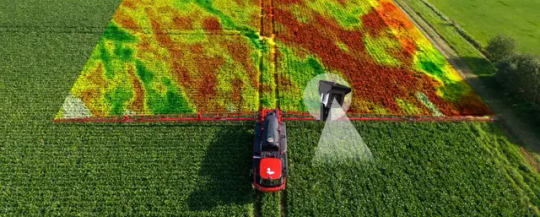
Agricultural Management and Precision Farming: Farmers leverage GIS to optimize agricultural practices by analyzing soil conditions, crop health, and weather patterns. Precision farming techniques, facilitated by GIS, contribute to increased crop yields and sustainable farming practices.
Real Estate and Property Management: In the real estate sector, GIS aids in property mapping, land valuation, and site selection. It provides real estate professionals with valuable insights into spatial relationships, market trends, and optimal development opportunities.
Tourism and Recreation: GIS enhances the tourism industry by providing interactive maps, route planning, and location-based information. It assists tourists in exploring destinations, finding attractions, and navigating efficiently.
The broad and varied involvement of GIS in our daily lives underscores its significance as a technology that not only facilitates geographic data analysis but also contributes to the efficiency, safety, and interconnectedness of modern society. As GIS applications continue to evolve, their impact on daily activities is expected to further expand and refine.
#gis#architectdesign#architecture#city#education#geographic information system(gis)#geographical indication
8 notes
·
View notes
Photo

1984 Panasonic Camcorder ad
#my gif#panasonic#camcorder#1984#1980s#gif#gis#vintage#commercial#beach#vhs#video cassette recorder#vcr#video camera
116 notes
·
View notes
Text
Stupid GIS class assignments will be like, “Pick a single location to do an analysis on. Out of literally every single iota of land on the entire planet Earth, chose 1 (one) for the sake of learning how to use the software. Have fun :)” as if choosing a single location for a focused, in-depth analysis isn’t going to be the longest and hardest part of the entire assignment. i have data for the ENTIRE EARTH at my fingertips, ready for all sorts of different explorations and learning, and you expect me to just. casually pick somewhere???
99 notes
·
View notes
Text
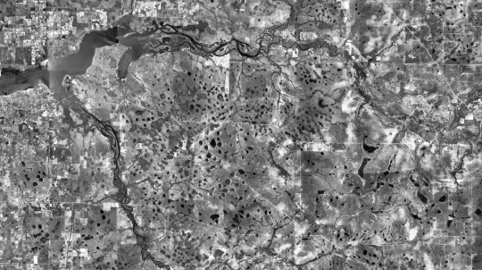
It's one thing to know theoretically that you live on a giant sponge, and another to actually see it from a bird's-eye view.

Picture is a 1940's aerial of a river in peninsular Florida. All the small dark blob shapes are lakes and depression marshes and springs and seeps.
15 notes
·
View notes
Text
Does anyone by chance have free GIS/mapping software they would recommend?
#I'd like to keep better track of where I've been/what I've found this year#and where I'd like to go#whether or not my old laptop is willing to run it is a different question#but I can dream#GIS
6 notes
·
View notes
Last Seen Blogs

smile-files
wowee zowee

aspireworldimmigration208
ASPIRE WORLD IMMIGRATION CONSULTANCY

batsyhope
batsy

jasin007
Senza titolo

lanternoik
lanternik