#remote sensing
Text


22.09.2023
I realised that I need to brush up my remote sensing knowledge 🫠
#Remote Sensing#studyblr#geography#study#desk#motivation#uni#mine#study setup#studying#study aesthetic#geo#Science#women in stem
160 notes
·
View notes
Link
51 notes
·
View notes
Text


Top On Sale Product Recommendations!;Women's Clitoris Sucker Remote Control Wearable Sucking Vibrator for Women Clitoral Vibrator Women's Panties Sex Toys Sex Shop
Original price: USD 28.38
Now price: USD 9.93
Click & Buy: https://s.click.aliexpress.com/e/_onPhEZs
#gift for her#lick my pussy#hot girsl#hot nude#high vibration#female sex toys#women sexi#for sucking that abusers meat#remote sensing
7 notes
·
View notes
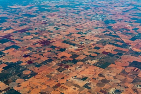
Text


Atlas of Human Settlements
Inland Empire, CA, 2023
#satellite#segmentation#remote sensing#builtup#atlasofhumansettlements#georgios ouzounis#deep learning#ai#artificial intelligence
10 notes
·
View notes
Video

flickr
Openings and Conclusions 9 by Russell Moreton
Via Flickr:
On the horizon, then, at the furthest edge of the possible, it is a matter of producing the space of the human species-the collective (generic) work of the species-on the model of what used to be called "art" ; indeed, it is still so called, but art no longer has any meaning at the level of an "object" isolated by and for the individual. Henri Lefebvre, Openings and Conclusions. from On Installation and Site Specificity (introduction) Erika Suderburg
#Research Collage#Working Notes#Interior Documents#Visualisations#Architectures#Spaces#Place#Embodiments#Practices#Texts#Material#Mappings#Drawings#Site#Localities#Mark Dion#Peter Greenaway#Herzog and de Meuron#Henri Lefebvre#Robin Evans#Kate Whiteford#Colin Renfrew#Remote Sensing#Archaeology#Rodin#Beuys#The Sensitivities of the Physical Self#Josef Albers#Waverley Abbey#Cistercian Monastery
2 notes
·
View notes
Text
youtube
A short animation generated from DESIS hyperspectral data (captured from the ISS). Spectral sensitivity increases from the 400-460um (near-UV) range up to 960-1000um (near infrared).
3 notes
·
View notes
Text
My first published paper!
Please check out my first published paper contribution! I was involved with the field work portion of this study as part of my master's degree in geography at the University of Utah. It's always exciting to expand my knowledge of geospatial technologies and evolve in the world of environmental science.
#geography#lidar#pinyon-juniper#big data#mapping#science#biomass#university of utah#remote sensing#ecology#environment#professional
3 notes
·
View notes
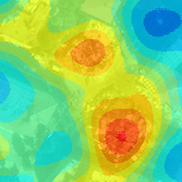
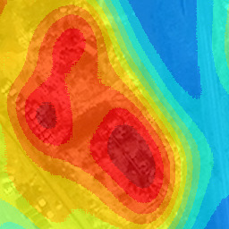
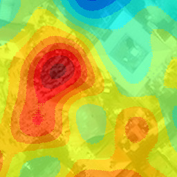
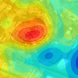
Photo
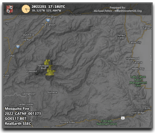
This is a timelapse of the #MosquitoFire near Lake Tahoe using GOES West B07 Enhanced ABI satellite imagery. #GIS #RemoteSensing
#fire#fires#wildland fires#wildfires#brush fires#cartography#gis#mapping#remote sensing#geography#pyrogeography#disasters#qgis#California#Mosquitofire#Lake Tahoe
24 notes
·
View notes
Text
LiDAR LiDAR Crocodile
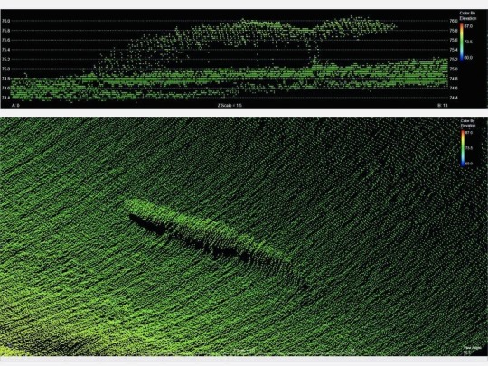
A gator caught hiding beneath the water with the magic of LiDAR. LiDAR (aka Light Detection and Ranging) uses lasers reflected from objects back to the source to reconstruct an environment
Original tweet:
“How cool is LiDAR? Well, it can see gators lurking beneath the surface, so I’d say it’s pretty dang awesome”

4 notes
·
View notes
Link
#Anthropogenic activities#Degradation of vegetation cover#Indices of spatial structure#Remote sensing#Burkina Faso
1 note
·
View note
Text
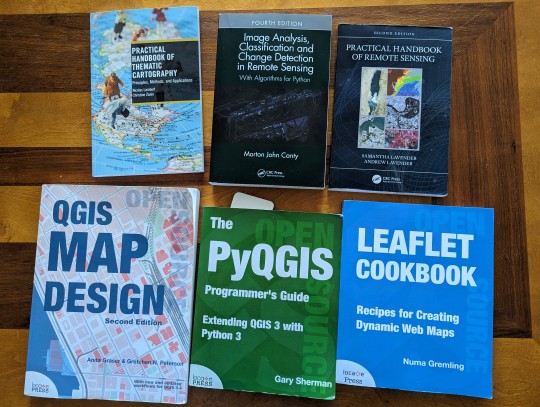
So, this is my current set of books to learn more about geospatial technologies, and how to build an online workflow with QGIS and Python.
5 notes
·
View notes
Text


6th of September 2023
🇩🇰 I love to bike everywhere! My butt hurts tho.
Learning a lot about remote sensing and spatial urban analysis this term 🍀
#studyblr#geography#study#desk#motivation#uni#mine#study setup#studying#study aesthetic#spatial studies#Remote sensing#analysis#studyspo#Copenhagen
54 notes
·
View notes
Text
That moment when you know far more about remote sensing than the average populace because of your degree of work. But your not entirely sure if the Victor 6000 sonar has the same regulations or works the same way as the sonar imaging you’ve studied
Because if it does you know why the Atlanta moved away from the direct ship site for a couple of reasons
(Basically in order to scan the area the ship needs to move at the bare basics)
And if it doesn’t you don’t know
2 notes
·
View notes
Text
Harnessing the Power of Hyperspectral Imaging in Agriculture
The field of hyperspectral imaging in agriculture is making significant strides, offering a wide range of benefits to the industry. Space technologies play a pivotal role in providing extensive coverage and with the application of hyperspectral imaging, offer crucial and granular insightsfor overall agricultural productivity.
This article discusses how this technology presents a valuable solution to tackle critical challenges faced by agricultural businesses, including crop health monitoring, yield improvement, pest detection, and nutrient content assessment.
Optimizing Crop Management and Yield Enhancement:
The agricultural sector faces several challenges regarding crop management and yield estimation and optimisation, while coping with a growing global population and declining natural resources. Traditional approaches to assessing crop and soil health are often labor-intensive, time-consuming, and lack accuracy, resulting in decreased productivity and adverse environmental impacts.
Hyperspectral Imaging utilizes its ability to capture a wide range of spectral bands to provide accurate and real-time information about the biochemical composition and health of crops. By providing precise information about variations in crop growth, nutrient imbalances, soil conditions, and early warnings for pest infestations and crop diseases, hyperspectral imaging empowers farmers and agronomists to make informed decisions and take timely actions.
Precise Weed Control and Nutrient Optimization:
One notable application of hyperspectral imaging is its ability to differentiate between crop species and weeds, facilitating targeted weed control measures, and reducing herbicide usage. By analyzing field-level details, farmers can observe changes in crop health and promptly address any issues.
Hyperspectral imaging also aids in monitoring nutrient content, pinpointing specific imbalances in plants or soil, enabling precise fertilization strategies, minimizing waste, and optimizing nutrient uptake.
Efficient Water Management, Effluent Monitoring, and Resource Conservation
Water scarcity and efficient water management, including effluent monitoring, are critical points of concern in modern agriculture. To address these challenges, hyperspectral imaging technology offers valuable insights and tools for optimizing water usage in agricultural systems.
By utilizing advanced sensors capable of capturing a wide range of electromagnetic wavelengths, hyperspectral imaging enables detailed monitoring of crop water stress, soil moisture levels, and irrigation needs. This capability enables farmers and agronomists to make data-driven decisions regarding irrigation scheduling, ensuring that water is applied precisely where and when it is needed.
By accurately assessing plant water status and optimizing irrigation practices, hyperspectral imaging helps conserve water resources, improve water use efficiency, and enhance crop productivity. Additionally, by integrating hyperspectral imaging data with other relevant parameters such as weather patterns and crop growth stages, farmers can develop predictive models and decision support systems for proactive water management, effluent monitoring, and resource conservation.
This holistic approach to water management empowers farmers to achieve sustainable agricultural practices, reduce water waste, and mitigate the impacts of water scarcity on crop production.
Early Disease Detection and Field Margin Monitoring:
Hyperspectral imaging contributes to early disease detection by analyzing the unique spectral signatures of crops, allowing farmers to proactively mitigate their spread and minimize crop losses. Additionally, hyperspectral imaging supports field margin monitoring, by providing valuable insights to assess and manage the health and biodiversity of these critical areas.
Furthermore, hyperspectral imaging assists in effluent monitoring, tracking, and managing agricultural waste and its environmental impact.
Precision Agriculture: Optimizing Crop Health and Variety Selection
In the realm of precision agriculture, hyperspectral imaging presents itself as a powerful tool for enhancing vegetation stress assessment and crop classification. By capturing data on stressors like water scarcity, nutrient imbalances, and pest infestations, hyperspectral imaging offers valuable insights into the overall health of crops. Armed with this information, farmers can proactively implement targeted mitigation measures to ensure optimal productivity.
Furthermore, the high spectral resolution of hyperspectral imaging enables accurate classification of different crop varieties based on spectral data analysis. This capability empowers farmers to effectively manage their fields, selecting the most suitable crop varieties for specific environmental conditions. By harnessing the precision of hyperspectral imaging, farmers can further optimize their operations, promote crop health, and maximize yields in the realm of precision agriculture.
Hyperspectral imaging is capable of addressing key challenges and providing valuable insights for efficient crop management. Embracing the potential of hyperspectral imaging is a vital choice for the agricultural industry to unlock its full range of benefits, leading to enhanced yields, improved pest detection, optimized nutrient assessment, efficient soil health evaluation, accurate disease detection, meticulous field margin monitoring, and informed pasture and herbal ley management.
As the agricultural sector continually seeks innovative and sustainable practices, hyperspectral imaging paves the way for a more productive and environmentally conscious future across the field.
#Hyperspectral Imaging#agtech#agritech#agriculture#farming#multispectral#satellite imagery#satellite#remote sensing
2 notes
·
View notes
Text


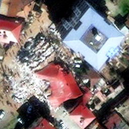
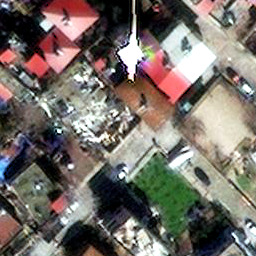

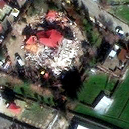
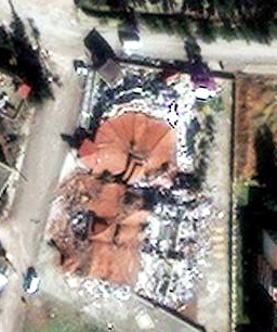
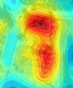


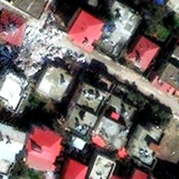
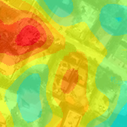
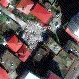

Collapsed building detections in south-east Turkey following the Feb. 6, 2023 earthquake.
Automated proposals of collapsed buildings are generated by a rubble detector followed by spatial aggregation.
Original images are property of Maxar Technologies, and are made publicly available under the Open Data Program
#satellite#remote sensing#artificial intelligence#builtup#machine learning#deep learning#ai#earthquake#turkey#rubble detection#rubble
23 notes
·
View notes
Video

flickr
Openings and Conclusions 6 by Russell Moreton
Via Flickr:
Collage on paper, written fragments and images from Peter Greenaway, Josef Albers and Robin Evans. Photo montage of The Physical Self (Greenaway) and Waverley Abbey UK. Visual research as part of The Waverley Project/Obscura and Reading Room. On the horizon, then, at the furthest edge of the possible, it is a matter of producing the space of the human species-the collective (generic) work of the species-on the model of what used to be called "art" ; indeed, it is still so called, but art no longer has any meaning at the level of an "object" isolated by and for the individual. Henri Lefebvre, Openings and Conclusions. from On Installation and Site Specificity (introduction) Erika Suderburg
#Research Collage#Working Notes#Interior Documents#Visualisations#Architectures#Spaces#Place#Embodiments#Practices#Texts#Material#Mappings#Drawings#Site#Localities#Mark Dion#Peter Greenaway#Herzog and de Meuron#Henri Lefebvre#Robin Evans#Kate Whiteford#Colin Renfrew#Remote Sensing#Archaeology#Rodin#Beuys#The Sensitivities of the Physical Self#Josef Albers#Waverley Abbey#Cistercian Monastery
2 notes
·
View notes
Last Seen Blogs

dokupine
Oops We Went Too Far

demateus1
demateus1


helenajam
be happy or die

daportalpractitioner
da portal practitioner