#Azimuth 236
Video
My Refuge Amongst the Forest and Mountains of Great Basin National Park by Mark Stevens
Via Flickr:
A setting looking to the southwest while taking in views of bristlecone pines in this grove present in Great Basin National Park. What I wanted to capture with this image was a look up a mountainside and cliff wall that had bristlecone pines seemingly growing off the edge. I also liked how the greens of those pines were a color contrast to the rock face they were growing on. I felt that color difference helped them to stand out more.
#Azimuth 236#Blue Skies#Bristlecone#Bristlecone Grove Trail#Day 6#DxO PhotoLab 5 Edited#East Central Great Basin Ranges#Forest#Forest Landscape#Great Basin National Park#Great Basin Ranges#Hillside of Trees#Intermountain West#Landscape#Landscape - Scenery#Looking SW#Mountain Peak#Mountains#Mountains in Distance#Mountains off in Distance#Mountainside#Nature#Nikon D850#No People#Outside#Portfolio#Project365#Ridge#Ridgeline#Ridges
2 notes
·
View notes
Text
0 notes
Video
THE NIGHT-MERMAID Film by and starring in: Penumbra Carter 2020 Filmed in Second Life at: Blake Sea - Swab (45, 241, 10) Blake Sea - Azimuth (157, 167, 7) Blake Sea - China (230, 153, 3) Blake Sea - Sirens Isle (236, 33, 8) Blake Sea - Jones Locker (134, 87, 17) The Citadel, Nautilus - Hannibal (247, 4, 11) Protected Land, Nautilus - Byth (151, 193, 18) The Leviathan Skeleton, Ahab's Haunt (124, 162, 10) Blake Sea - Indian (134, 88, 20) Glacis Isle (124, 113, 4) Anse Etoile Isle (127, 115, 2) Coastal Waterway, Sieraf (85, 116, 7) Coastal Waterway, Leoming (78, 124, 5) Attachments to Mermaid Mermaid Tail by MW Boa Tala AO(5Joints) by Bet (bet.quinote) flexi sleeve l upper arm by Mystygry Mirihi Tidal~ Smooth Glider Fin - Lace - BLUE by Graea AVZ ~ Parallel Hair (Platinum) by Hern Worsley virus face mask (breath) by Dekka Raymaker Ventilator,ball/stick molecule crown,cockroach sailing boat and corona virus by Penumbra Carter Sounds Used With Permissions Arpeggiator End Credits .wav by lharman94 strings 19 by Hoerspielwerkstatt_HEF Cinematic Soundtrack Test by BeatArchive C#m7 to C#7 11.wav by esistnichtsoernst Wide Cinematic Anxious Drone by Free-Rush charade 1Q62b by Setuniman Atmospheric Piano & Violin Music 01 by Magmi. Soundtracks Cinematic Bass Swell (C) by PicturEsqueSound KRUCIFIX PRODUCTIONS CINEMATIC SOUND SADNESS 2018.wav by Krucifix444
0 notes
Link
We now know, of course, that at a time when European seafaring was a mostly coast-hugging, tentative affair, loin-clothed “primitives” of Asian origin were braving the long swells of the Pacific. Their craft were probably sennit-lashed vessels of low freeboard (Sinoto 1983) and their navigational feats seemingly uncanny. Thanks to the recent work of such scholars and experimenters as Dodd, Finney, Goodenough, Alkire, Gladwin, and Lewis we now have a good idea of how such long-distance navigation may have taken place. The “discovery” of modern practitioners of the indigenous arts of noninstrumental celestial navigation, especially in Micronesia, has shed much light on the particulars of Pacific wayfinding.
Michael Halpern. “Sidereal Compasses: a Case for Carolinian-arab Links.” The Journal of the Polynesian Society. Volume 95, No. 4, p 441-460.
Remnants of star path and star compass navigational systems can be found in both the lore and current usage, as well as Western historical accounts, of other Indo-Pacific peoples. From all across this region comes evidence of long-distance voyaging and indigenous celestial navigation (D. Lewis 1964, 1972, 1978b; Best 1922:28; Dodd 1972:49; Ellis 1831:168; Da Silva and Johnson 1982:313–22; Haddon 1937:93; Sarfert and Damm 1929:187, 195; Liechti et al. 1980:2–4; A. Lewis 1973:252 n.3; Ferrand 1919:160). The present discussion will focus on the best available evidence, that from the Carolines.
All these star systems were made possible by a peculiarity of tropical naked-eye astronomy. In all latitudes stars appear to rise and set at the same point on the horizon throughout the year (Thomas 1982:2). But only relatively close to the equator is their motion vertical as they leave or approach the horizon. Beyond the tropics, stars rise and set obliquely, describing a circle about the celestial pole, the projection of the terrestrial pole on to the “dome” of the heavens (Aveni 1981). This vertical motion allows stars to be used as directional indicators some distance from the tropical horizon. In temperate zones, their oblique motion near the horizon markedly reduces their directional usefulness.
Carolinian navigators still use their sidereal compass to effect voyages often hundreds of kilometres in length (Gladwin 1970:37–39; D. Lewis 1978b:162–3, 177–80). And evidence from Western observers as well as indigenous tradition indicates that such long trips were more common in the past (Parsonson 1963:33; Åkerblom 1968:115; Lewthwaite 1967:76). Meanwhile, a cultural and geographical world away, Arab navigators also used the stars to guide them at sea (Taylor 1957:128). Interestingly, here, too, we find a sidereal rose showing remarkable similarities to the Carolinian (Fig. 2). A diagram of the rose was copied in the early 19th century from an Arab nautical treatise, the Majid Kitab (Prinsep 1836:Plate 48, 788). Its use is described in the Muhit, a 16th century Turkish work (Von Hammer 1834:548, 1838:768–9), though its representational roots probably reach much deeper into history (Ferrand 1928:198; 225; Tibbetts 1971:296). The Arab and Carolinian compasses share 18 points in common. Further, Arab navigators spoke of setting courses on the names of stars rather than in degrees even when the latter were available (Prinsep 1836:788–9). The version of this rose that has come down to us clearly postdates the introduction of the magnetic compass. The azimuths are regularly spaced and accompanied by degree notations. Their names, taken from the rising and setting points of stars, must be mere conventions.
[...]
By calculating the positions of the individual stars and constellations of the Arab rose at various times in the past, it can be seen that their relative positions did, indeed, correspond to those of the currently known representation. 3 This tends to confirm the speculations of both Prinsep (1836:788) and de Saussure (1928:124) that an Arab sidereal rose predated the use of stellar rhumb names on their magnetic compasses. As recently as A.D. 1000, for instance, Canopus was about the same distance from the equator as the prominent stars of the Southern Cross. In ancient times it was farther south, suggesting a cause for its choice as the rose's southern marker. The same precessional change resulted in the shift in the relative positions of Canopus and Alpha/Beta Centauri sometime between 1500 and 2000 years ago. Before that time, their depiction in the Arab rose accurately reflected their actual relationship. The Antares-Pleiades configuration displays a similar pattern. Just before A.D. 1000 Arcturus rose several degrees north of the Pleiades, as in the Arab compass. This gap increases as we recede further into the past, at least to 3500 B.C. The calculations show that at about the beginning of our own era, approximately 2000 years ago, all the stars held relative positions in the sky just as they are found in the representation of the Arab sidereal rose. Several hundred years earlier or later this was not the case.
There is, however, a complicating factor. Some of the gaps between adjacent calculated bearings are very small, on the order of a degree or two (e.g., Capella and Vega). The problem arises, then, of explaining - 447 why a navigator would choose two azimuths in such close proximity. While there is no definitive answer, one need only look to the still-functioning Carolinian compass for instruction. Here, the azimuths denoted by Tarazed (Gamma Aquilae) and Altair, the two closest of the entire compass, show a difference of barely 2° in their rising points along the horizon from the approximate latitude of the Carolines chain. This bunching of points around the east-west line presumably serves the local needs of the navigators since most voyaging was and is along the main axis of the chain (Gladwin 1970:152, 154 but see D. Lewis 1972:67). A similar explanation in the Arab case is plausible, though less readily understandable in light of the scanty information and long, open-water sea routes of the Indian Ocean.
[...]
But what of the Arab compass? Altair appears to rise even farther from true east, though only marginally, from the slightly higher latitudes frequented by Arab seafarers. Here too, then, it could not have been chosen because of some past correspondence with the celestial equator. Both Ibn Majid, the famous 15th century navigator and his 16th century Turkish translator, Admiral Sidi Ali Çelebi, were aware of the Altair discrepancy and the latter, at least, knew of precessional changes (Grosset-Grange 1972:39; Ferrand 1919:500–01). Tibbetts (1971:150) states that, while the “ancients” were aware of Altair's true position, early mariners used it anyway because their measurements were only approximate and because “the seamen of the Indian Ocean and others relied on it and so described it to each other.” If true, this would be a strong indication that early Arab navigators learned the use of the sidereal rose from other seafarers plying the Indian Ocean. These “others” were, perhaps, Austronesian cousins of the Carolinians.
Celestial longitude is usually designated by right ascension, a temporal measure based on the equivalence of 360° of longitude and 24 sidereal hours. It is measured in hours and minutes east from the vernal equinox. For example, a star found 60° east of the zero point has a right ascension of four hours (Jastrow and Thompson 1972:I–21 — I–23). Though the rising times of the Carolinian compass stars are generally spread out over a given 24-hour period, gaps do occur. This is not a serious problem for the navigator since the companion stars, those of similar declination but different right ascension, serve during these periods. Conveniently, the Carolinian compass calculated for 2000 years ago displays one large gap which falls entirely in daylight hours during the voyaging season. The differing conditions of Indian Ocean monsoon sailing eliminates this correspondence, though the voyaging season was much more flexible in these seas (Grosset-Grange 1970:236–38, 1978:18, Fig. 6). The companion stars would, of course, have permitted use of the compass at any time. This is one more indication, however, that the Arabs were working with a borrowed system.
The Arab rose of 2000 years ago (calculated) shows a bunching of azimuths around due north. This fact, plus the Arabs' well-known skill at latitude sailing by the height of Polaris and circumpolar stars (Prinsep 1836; Ferrand 1928; Tolmacheva 1980) might argue for a more northerly origin of their compass. But as we have seen, the astronomical requisites of navigation by rising and setting azimuths are particular to tropic regions. The Arabs' facility at latitude sailing carried them at least as far as India (and later to China and the East Indies) where they could have met Tibbetts' “seamen of the Indian Ocean and others,” possibly from or in contact with tropical Indo-Pacific lands, who taught them to key their compass to Altair. Such contact may have also led to the Arabs' use of the height of al-Murabba', the Southern Cross, for latitude determination south of the equator (Tibbetts 1971:340), though they may have discovered it themselves on voyages to the east or south to Madagascar.
There is, however, important evidence of former star compass use elsewhere in the Pacific. On Tonga, an elder of a traditional clan of navigators named “eight star points indicating directions rather than the positions of islands...” (D. Lewis 1978b:76). These had been learned from his father who reportedly knew more than he. In Tahiti Andia y Varela found a 16-point compass rose in use near the end of the 18th century, east being the principal direction (D. Lewis 1964:365). And David Malo reported that in Hawaii the stars were used as a compass (Hornell 1936:25). From the island of Madura off Java's north coast comes the report that there were 25 stars basic to navigational science, their rising and setting points constituting the bintang pedoman or star compass. Here, Altair was considered of primary importance, though not all the azimuths were remembered by the informants (Liechti et al. 1980:2–4). Though there is some question as to the accuracy of the star names reported (Horridge 1984; D. Lewis 1984; Frake 1984), the compass suggested by the researchers may have been a system of star path navigation used in conjunction with a cognitive directional system based on wind or other names. Support for the validity of this rose comes from an unusual quarter: Ibn Majid, the 16th-century Arab pilot. He claimed that, while most seafaring peoples of the Indian Ocean used a 32-point compass, the Chinese and Javanese roses contained only 24 stations (Ferrand 1924:216). It is not difficult to imagine that Majid's 24-point Javanese compass and the 25 stars of the Madurese informants refer to the same construct.
0 notes
Video
Pacific Ocean Beaches in Del Norte Coast Redwoods State Park (Black & White) by Mark Stevens
Via Flickr:
A conversion to black & white using DxO PhotoLab 5 where I made some adjustments to color filters to bring out a much richer tonal contrast for the final image. One of the things that drew me into this image after converting to black & white was the almost minimalist feel, especially with the overcast skies.
#Azimuth 236#Beach#Black & White#California Coastal National Monument#California State Route 1#California and Oregon Road Trip#Coastline#Day 9#Del Norte Coast Redwoods State Park#DxO PhotoLab 5 Edited#False Klamath Cove#Klamath Mountains#Landscape#Landscape - Scenery#Looking SE#Mostly Cloudy#Nature#Nikon D850#No People#Northwest U.S. Coast Ranges#Outside#Overcast#Pacific Coast#Pacific Coast Highway#Pacific Coastline#Pacific Ocean#Pacific Ranges#Portfolio#Project365#Redwood National and State Parks
3 notes
·
View notes
Video
Exploration of Inyo National Forest at Convict Lake by Mark Stevens
Via Flickr:
While walking the Lakeshore Trail and taking in views of nearby trees and mountains of the Mammoth Area range at Convict Lake in Inyo National Forest. The view is looking to the southwest with a haze overcast skies from nearby forest wildfires. For the post-production look, I specifically added a Sunlight and slightly red filtered Graduated User Defined CEP filter.
#Azimuth 236#California and Oregon Road Trip#Central Sierra Nevada#Cloudy#Color Efex Pro#Convict Lake#Day 3#DxO PhotoLab 5 Edited#Forest#Forest Landscape#Hillside of Trees#Inyo National Forest#Lakeshore Trail#Landscape#Landscape - Scenery#Laurel Mountain#Looking SW#Mammoth Area#Mono Jim#Mono Jim Peak#Mostly Cloudy#Mountain Peak#Mountains#Mountains in Distance#Mountains off in Distance#Mountainside#Nature#Nikon D850#No People#Outside
0 notes
Video
Pacific Ocean Beaches in Del Norte Coast Redwoods State Park (Black & White) by Mark Stevens
Via Flickr:
A conversion to black & white using DxO PhotoLab 5 where I made some adjustments to color filters to bring out a much richer tonal contrast for the final image. One of the things that drew me into this image after converting to black & white was the almost minimalist feel, especially with the overcast skies.
#Azimuth 236#Beach#Black & White#California Coastal National Monument#California State Route 1#California and Oregon Road Trip#Coastline#Day 9#Del Norte Coast Redwoods State Park#DxO PhotoLab 5 Edited#False Klamath Cove#Klamath Mountains#Landscape#Landscape - Scenery#Looking SE#Mostly Cloudy#Nature#Nikon D850#No People#Northwest U.S. Coast Ranges#Outside#Overcast#Pacific Coast#Pacific Coast Highway#Pacific Coastline#Pacific Ocean#Pacific Ranges#Portfolio#Project365#Redwood National and State Parks
1 note
·
View note
Video
Pacific Ocean Beaches in Del Norte Coast Redwoods State Park by Mark Stevens
Via Flickr:
A setting looking to the southeast while taking in views along the California coastline at Wilson Creek Beach in Del Norte Coast Redwoods State Park. I wanted to create a more sweeping view across the beach and ocean leading up to the rock formations in sea stack, so I decided to angle my Nikon SLR camera slightly downward.
#Azimuth 236#Beach#California Coastal National Monument#California State Route 1#California and Oregon Road Trip#Coastline#Day 9#Del Norte Coast Redwoods State Park#DxO PhotoLab 5 Edited#False Klamath Cove#Klamath Mountains#Landscape#Landscape - Scenery#Looking SE#Mostly Cloudy#Nature#Nikon D850#No People#Northwest U.S. Coast Ranges#Outside#Overcast#Pacific Coast#Pacific Coast Highway#Pacific Coastline#Pacific Ocean#Pacific Ranges#Redwood National and State Parks#Scenics - Nature#Sea Stacks#Siskiyou Mountains
1 note
·
View note
Video
Sunday Morning Happiness on the Pacific Coastline in Del Norte Coast Redwoods State Park by Mark Stevens
Via Flickr:
A setting looking to the southeast while taking in views along the California coastline at Wilson Creek Beach in Del Norte Coast Redwoods State Park. My thinking in composing this image was to angle my Nikon SLR camera slightly downward and create a sweeping view across this Pacific coastline beach. The waves coming into the shore with the beach would in someways be that leading line into the image.
#Azimuth 236#Beach#California Coastal National Monument#California State Route 1#California and Oregon Road Trip#Coastline#Day 9#Del Norte Coast Redwoods State Park#DxO PhotoLab 5 Edited#Klamath Mountains#Landscape#Landscape - Scenery#Looking SE#Mostly Cloudy#Nature#Nikon D850#No People#Northwest U.S. Coast Ranges#Outside#Overcast#Pacific Coast#Pacific Coast Highway#Pacific Coastline#Pacific Ocean#Pacific Ranges#Redwood National and State Parks#Scenics - Nature#Sea Stacks#Siskiyou Mountains#SnapBridge
0 notes
Video
Sunday Morning Happiness on the Pacific Coastline in Del Norte Coast Redwoods State Park by Mark Stevens
Via Flickr:
A setting looking to the southeast while taking in views along the California coastline at Wilson Creek Beach in Del Norte Coast Redwoods State Park. My thinking in composing this image was to angle my Nikon SLR camera slightly downward and create a sweeping view across this Pacific coastline beach. The waves coming into the shore with the beach would in someways be that leading line into the image.
#Azimuth 236#Beach#California Coastal National Monument#California State Route 1#California and Oregon Road Trip#Coastline#Day 9#Del Norte Coast Redwoods State Park#DxO PhotoLab 5 Edited#Klamath Mountains#Landscape#Landscape - Scenery#Looking SE#Mostly Cloudy#Nature#Nikon D850#No People#Northwest U.S. Coast Ranges#Outside#Overcast#Pacific Coast#Pacific Coast Highway#Pacific Coastline#Pacific Ocean#Pacific Ranges#Redwood National and State Parks#Scenics - Nature#Sea Stacks#Siskiyou Mountains#SnapBridge
1 note
·
View note
Video
flickr
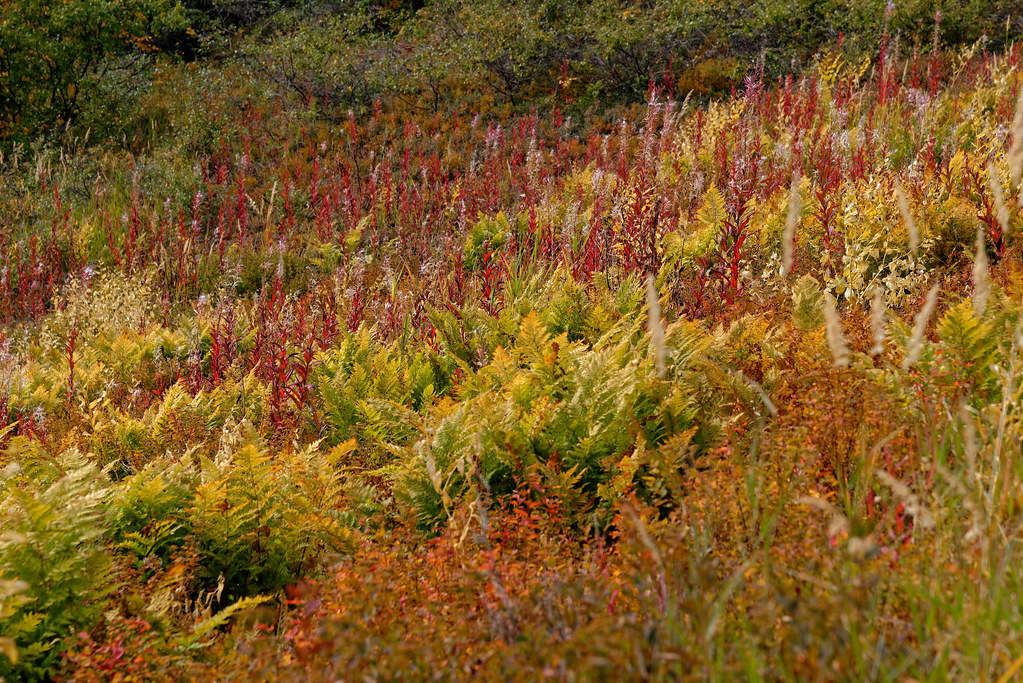
The Colors of Plant-life Amongst the Tundra (Denali State Park) by Mark Stevens
Via Flickr:
A view looking across a hillside that happened to have quite the colors present with plant life. This was while walking the Little Coal Creek Trail in Denali State Park.
#Alaska 2019#Alaska Range#Alaska-Yukon Ranges#Azimuth 236#Day 6#Denali State Park#DxO PhotoLab 3 Edited#Hayes Range#Image Capture With Arsenal#Landscape#Little Coal Creek Trail#Looking SW#Nature#Nikon D800E#Outside#Project365#Tundra#Wildflowers#With Arsenal#Alaska#United States
1 note
·
View note
Video
flickr
The Colors of Plant-life Amongst the Tundra (Denali State Park) by Mark Stevens
Via Flickr:
A view looking across a hillside that happened to have quite the colors present with plant life. This was while walking the Little Coal Creek Trail in Denali State Park.
#Alaska 2019#Alaska Range#Alaska-Yukon Ranges#Azimuth 236#Day 6#Denali State Park#DxO PhotoLab 3 Edited#Hayes Range#Image Capture With Arsenal#Landscape#Little Coal Creek Trail#Looking SW#Nature#Nikon D800E#Outside#Project365#Tundra#Wildflowers#With Arsenal#Alaska#United States
0 notes
Video
flickr
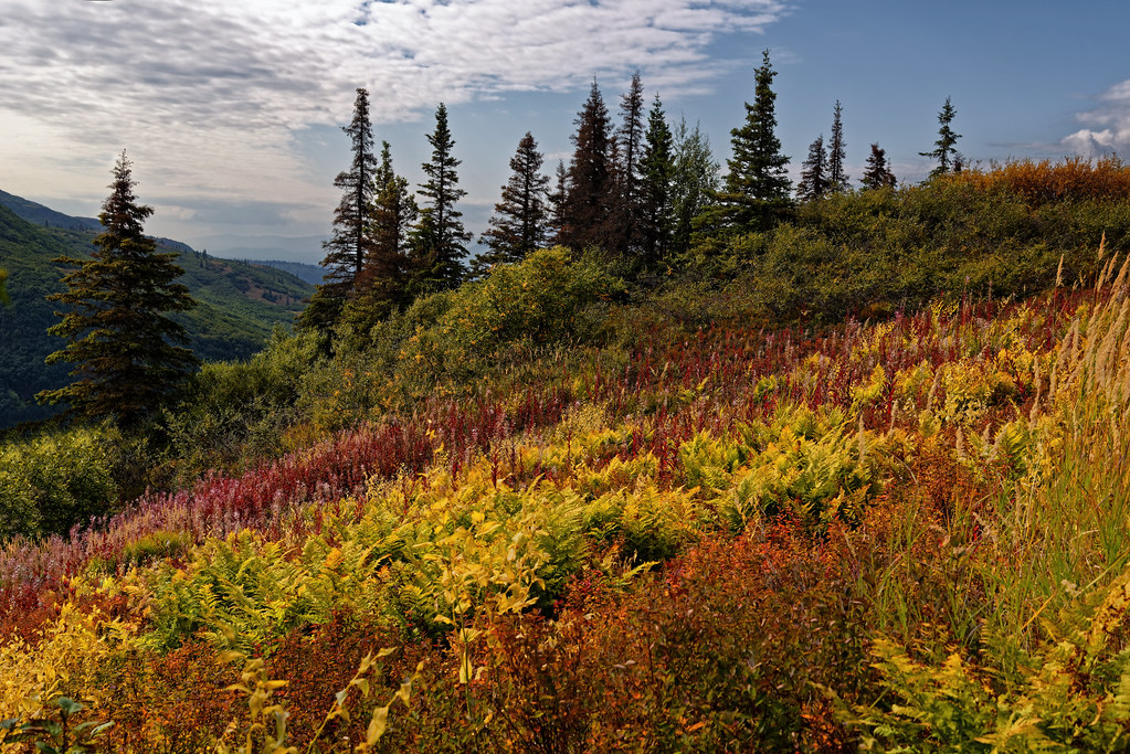
Welcome to There. The Place You've Wanted to Be! (Denali State Park) by Mark Stevens
Via Flickr:
A view looking to the southwest while hiking along the Little Coal Creek Trail in Denali State Park. This was a setting looking across some autumn colors coming out across the tundra along this hillside. While I could have composed the image with more of a wide angle view, I decided to focus the image across this one portion of the hillside and let the imagination of plants across this tundra continue beyond the image boundaries. The “impact of less,” so to speak. I could then angle my Nikon SLR camera slightly downward and capture more of a sweeping view across this hillside and minimize the mostly cloudy skies above that I felt were kind of a negative space for the setting and image captured. I did some initial post-processing work making adjustments to contrast, brightness and saturation while playing around as I learned how to work with DxO PhotoLabs 3 that I’d recently purchased after moving away from Capture NX2. I then exported a TIFF image to Nik Color Efex Pro 4 where I added a Polarization and Pro Contrast filter for that last effect on the image captured.
#Alaska 2019#Alaska Range#Alaska-Yukon Ranges#Azimuth 236#Blue Skies#Blues Skies with Clouds#Color Efex Pro#Day 6#Denali State Park#DxO PhotoLab 3 Edited#Evergreen Trees#Evergreens#Hayes Range#Hillside of Trees#Ideas I Got From Others#Image Capture With Arsenal#Landscape#Little Coal Creek Trail#Looking SW#Looking up Mountainside#Looking up a Mountainside#Mountains#Mountains in Distance#Mountains off in Distance#Mountainside#Nature#Nikon D800E#Outside#Partly Cloudy#Portfolio
0 notes
Video
flickr
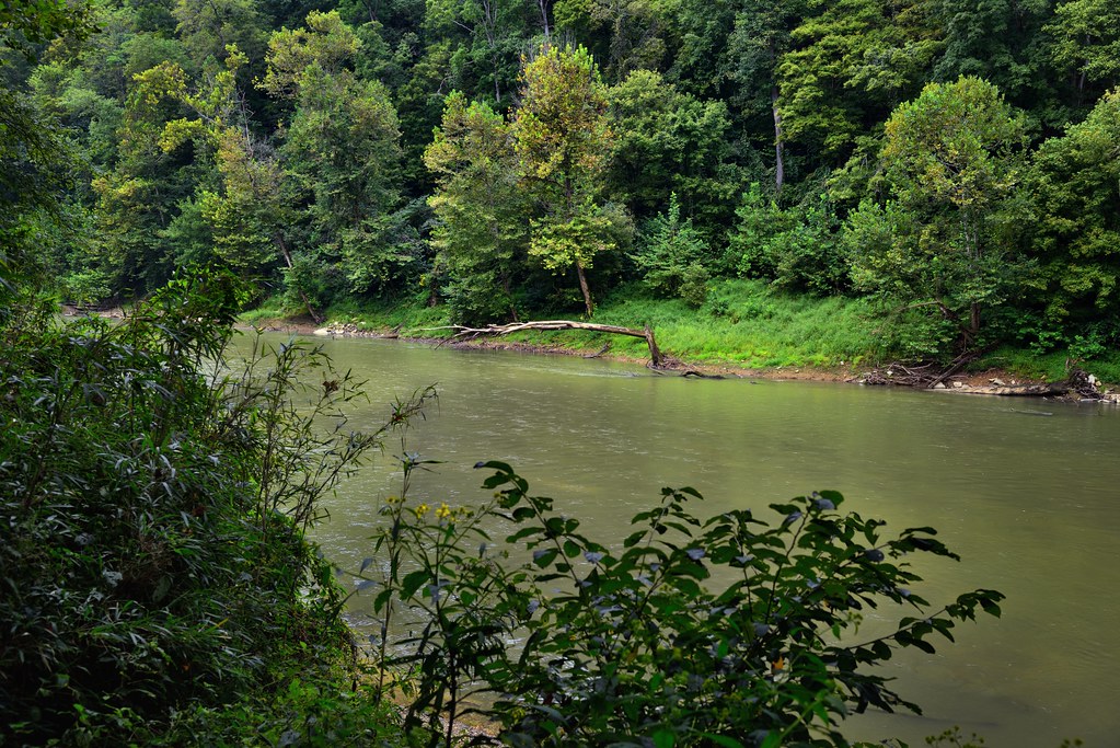
Green River and a Forest of Trees (Mammoth Cave National Park) by Mark Stevens
Via Flickr:
With a shorten time frame for walking and exploring this part of the national park, I didn't have a lot of chances to take in much of the views while walking the Green River Bluffs Trail. So from this high bluff, I took advantage of the perspective to capture this look across the Green River to a hillside of trees on the other side. With some work with color control points in Capture NX2, I was able to bring out much more fo the vibrant greens I imagined on a non-overcast day.
#Appalachian Mountains#Appalachian Plateaus#Azimuth 236#CamRanger#Capture NX2 Edited#Central Cumberland Plateau#Color Efex Pro#Cumberland Plateau#Day 4#Green River#Green River Bluffs Trail#Hillside of Trees#International Biosphere Reserve#Landscape#Looking SW#Mammoth Cave National Park#Nature#Nikon D800E#Outside#Project365#River#Rolling Hillsides#Tall Trees#Tall Trees All Around#Travel#Trip to Gateway Mammoth Cuyahoga National Parks#Visitor Center Area Trails#World Heritage Site#Capture with CamRanger#Trees
0 notes
Video
flickr
Welcome to There. The Place You've Wanted to Be! (Denali State Park) by Mark Stevens
Via Flickr:
A view looking to the southwest while hiking along the Little Coal Creek Trail in Denali State Park. This was a setting looking across some autumn colors coming out across the tundra along this hillside. While I could have composed the image with more of a wide angle view, I decided to focus the image across this one portion of the hillside and let the imagination of plants across this tundra continue beyond the image boundaries. The “impact of less,” so to speak. I could then angle my Nikon SLR camera slightly downward and capture more of a sweeping view across this hillside and minimize the mostly cloudy skies above that I felt were kind of a negative space for the setting and image captured. I did some initial post-processing work making adjustments to contrast, brightness and saturation while playing around as I learned how to work with DxO PhotoLabs 3 that I’d recently purchased after moving away from Capture NX2. I then exported a TIFF image to Nik Color Efex Pro 4 where I added a Polarization and Pro Contrast filter for that last effect on the image captured.
#Alaska 2019#Alaska Range#Alaska-Yukon Ranges#Azimuth 236#Blue Skies#Blues Skies with Clouds#Color Efex Pro#Day 6#Denali State Park#DxO PhotoLab 3 Edited#Evergreen Trees#Evergreens#Hayes Range#Hillside of Trees#Ideas I Got From Others#Image Capture With Arsenal#Landscape#Little Coal Creek Trail#Looking SW#Looking up Mountainside#Looking up a Mountainside#Mountains#Mountains in Distance#Mountains off in Distance#Mountainside#Nature#Nikon D800E#Outside#Partly Cloudy#Portfolio
0 notes
Text
0 notes
Last Seen Blogs

loldontdoit
I Was Born A Human

belladt18
Sin título

call-me-kore
a healthy dose of heartache

kunkhmermartialarts
Untitled

santoshkukreti04-blog
Untitled