#Peninsular Southern California Ranges
Video

flickr
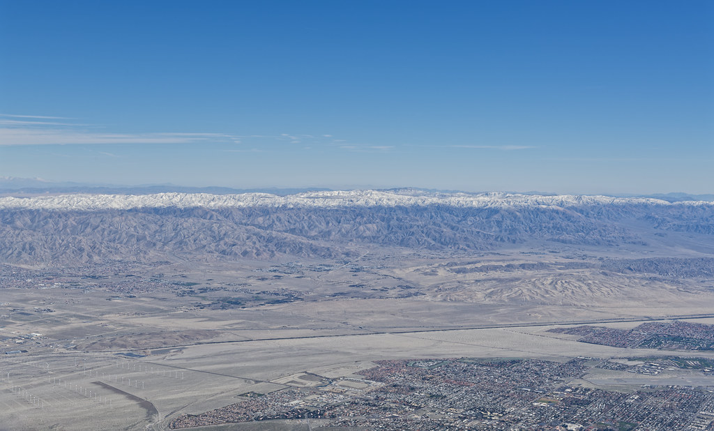
Stopping by to See Some Woods on a Snowy Morning in the San Jacinto Mountains by Mark Stevens
Via Flickr:
A setting looking to the southwest while taking in views at the Palm Springs Aerial Tramway Mountain Station and across a snowy landscape with a forest of evergreen trees. This is in Mount San Jacinto State Park.
#Azimuth 208#Blue Skies#Central and Southern California Ranges#Day 3#Desert Mountain Landscape#Divide Peak#DxO PhotoLab 6 Edited#Joshua Tree National Park and California#Landscape#Landscape - Scenery#Looking SW#Luella Todd Peak#Marion Mountain#Mount San Jacinto State Park#Mountain Peak#Mountain Station#Mountains#Mountains in Distance#Mountains off in Distance#Mountainside#Nature#Nikon D850#No People#Outside#Pacific Ranges#Palm Springs Aerial Tramway#Peninsular Southern California Ranges#Project365#Ridge#Ridgeline
2 notes
·
View notes
Text
Pronghorn Antelope
Amazing North American animals. They’re the fastest animal in North America, with the ability to run at 95 mph:
youtube
They migrate in large herds in the front range and in the Rocky Mountains. Think about the millions of these guys plus the original number of bison, and all the other wildlife, and you can imagine that this area deserves the designation of Serengeti of North America:
youtube
And they block humans when they feel like it:
youtube
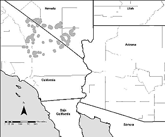
Then the peninsular pronghorn, which are endangered. Same species, I think (a naturalist will probably yell at me for saying that), but they live in the desert areas of Mexico, Arizona and, until recently, southern California (but eventually they will get reintroduced in soCal)
youtube
15 notes
·
View notes
Photo

San Antonio is a small town in La Paz Municipality in the Mexican state of Baja California Sur, located near El Triunfo on Federal Highway 1. In the Sierra de la Laguna is a mountain range at the southern end of the Baja California Peninsula in Mexico, and is the southernmost range of the Peninsular Ranges System.
The Sierra is home to many endemic species and subspecies.
Some of the more common plants restricted to the region are Bidens cabopulmensis, Diospyros intricata, Erythranthe lagunensis, Heimia salicifolia, Hibiscus ribifolius, Indigofera fruticosa, Physalis glabra, Quercus brandegeei, Sida xanti, Stenotis asperuloides, and Yucca capensis.


0 notes
Photo
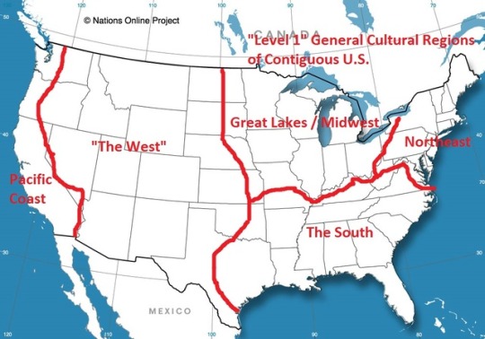
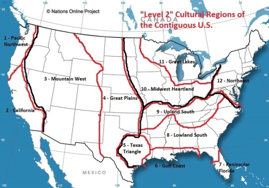
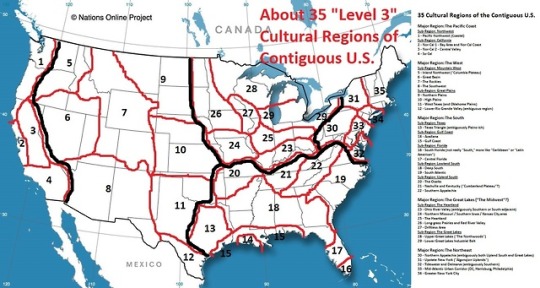


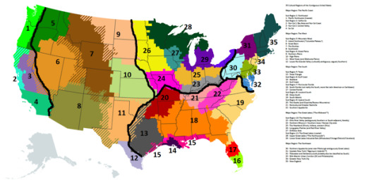
Sorry to inflict this upon you. If you thought I was “fun,” think again. Look what I do in my free time. Some nonsense I put together to explain to a friend how I perceive the cultural regions of the contiguous United States.
Map 1: Level 1 -- 5 major cultural regions of the contiguous U.S.
Map 2: Level 2 -- 12 cultural sub-regions.
Map 3: Level 3 -- 35 cultural regions (You could get away with adding a few more, or, specifically, 3 more: Colorado’s Front Range, Arizona’s Sun Corridor, and separate urban/coastal New England from rural/inland New England.).
Map 4: Another approach at Level 2 cultural regions, featuring 16 regions instead of 12.
Maps 5 and 6: The same 35 cultural regions but ~IN COLOR~ and with transition zones.
-
The 35 “Level 3″ cultural regions:
Major Region: The Pacific Coast
Sub-Region 1: Northwest
1 - Pacific Northwest (Coastal)
Sub-Region 2: California
2 - Nor-Cal 1: Bay Area and Nor-Cal Coast
3 - Nor-Cal 2: Central Valley
4 - So-Cal
Major Region: The West
Sub-Region 3: Mountain West
5 - Inland Northwest (”Columbia Plateau”)
6 - Great Basin
7 - The Rockies
8 - Southwest
Sub-Region 4: Great Plains
9 - Northern Plains
10 - High Plains
11 - West Texas (and Oklahoma Plains)
12 - Lower Rio Grande Valley (culturally ambiguous; vaguely Southern)
Major Region: The South
Sub-Region 5: Texas
13 - Texas Triangle
Sub-Region 6: Gulf Coast
14 - Acadiana
15 - Gulf Coast
Sub-Region 7: Peninsular Florida
16 - South Florida (not really the South, more like Latin American or Caribbean)
17 - Central Florida
Sub-Region 8: Lowland South
18 - Deep South
19 - South Atlantic
Sub-Region 9: Upland South
20 - The Ozarks (and Ouachita/Boston Mountains)
21 - Kentucky and Greater Nashville
22 - Southern Appalachia
Major Region: The Great Lakes (”The Midwest”?)
Sub-Region 10: The Heartland
23 - Ohio River Valley (ambiguously Southern or South-adjacent, literally)
24 - Northern Missouri / Southern Iowa / Kansas City-area
25 - The Heartland (Illinois, Indiana, western Ohio)
26 - Long-grass Prairies (and Red River Valley)
27 - Driftless Area
Sub-Region 11: The Great Lakes (coastal)
28 - Upper Great Lakes (”The Northwoods”)
29 - Lower Great Lakes Industrial Belt (Milwaukee/Chicago/Detroit/Cleveland)
Major Region: The Northeast
30 - Northern Appalachia (area near Pittsburgh ambiguously Great Lakes)
31 - Upstate New York (”Algonquin Uplands”?)
32 - Tidewater and Delmarva (could probably also be classified as South)
33 - Mid-Atlantic Urban Corridor (DC and Philadelphia)
34 - Greater New York City
35 - New England
-
Sorry.
27 notes
·
View notes
Photo

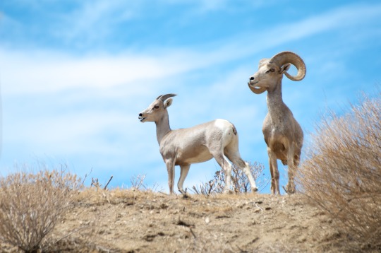
Desert bighorn sheep (Ovis canadensis nelsoni) are one of three bighorn sheep subspecies. They can be found throughout the southwestern United States and northern Mexico. Since 1998, bighorn sheep living in the peninsular mountain ranges of southern California (which extend into Mexico) have been protected under the Endangered Species Act.
BORDERLESS KINGDOM || info | art
[find me: shop - ig - tweet - ko-fi]
#bighorn sheep#wildlife#illustration#animal art#endangered species#borderless kingdom#i spent SO MUCH TIME reading about these guys#including srp documents and annual reports on peninsular bighorns#but i was pulling my hair out trying to write a decent summary#and idk if anyone even wants to read it#or if a wall of text w/ the art discourages#reblogging for the Aesthetic#so u kno we'll try short and sweet for a while#there'll be links on the info page eventually if you do want to read more
6 notes
·
View notes
Video
youtube
The Sierra de la Laguna is a mountain range at the southern end of the Baja California Peninsula in Mexico, and is the southernmost range of the Peninsular Ranges System. It is located in La Paz Municipality and Los Cabos Municipality of southern Baja California Sur state. The "Sierra de la Laguna High Point", at 6,857 feet (2,090 m) in elevation, is the highest point of the range and in Baja California Sur state. It has a distinctive flora and fauna, with many affinities to Southwestern Mexico. The Sierra is home to many endemic species and subspecies. UNESCO has designated the Sierra de la Laguna a global biosphere reserve:
"This semi arid to temperate subhumid climate area represents highly important and contrasted ecosystems, including arid zones, matorrales, low deciduous forest type, evergreen oak: Quercus devia (“encino”) woods, pine-evergreen oak mix woods and oases with palms and “guerivos” situated throughout the gallery forest following the long river basins."
The Biosphere reserve was established by a Mexican presidential decree of 6 June 1994, which designated a core area and buffer zones. The core area is centered on the higher-elevation oak-pine forests, while the transition area includes the communities of Todos Santos, El Pescadero, El Triunfo, San Antonio, San Bartolo, Buena Vista, Los Barriles, Las Cuevas, Santiago and Miraflores.
2 notes
·
View notes
Link
This Binding Woods for Guitars is supplied by the Exotic Wood Zone which has a collection of some of the finest and high quality Luthier Tonewoods & exotic wood products. Our products are defect-free and we guarantee 100% product satisfaction. We are happy to answer your queries to serve you better.
If for any reason you are not happy with your selection we offer a 100% MONEY BACK GUARANTEE!
We Are Selling Different Species Of Bindings:
Acacia:
Common Names: Australian blackwood, Acacia blackwood.
Botanical Name: Acacia melanoxylon
Australian Blackwood/Acacia is easily worked with both hand and machine tools, though figured wood and pieces with interlocked grain can cause tearout. Australian Blackwood turns, glues, stains, and finishes well. Responds well to steam bending.
African Blackwood:
Common Names: African blackwood, Mpingo (Swahili)
Botanical Name: Dalbergia melanoxylon
African blackwood is very expensive, on par with true ebonies such as Gaboon Ebony in the Diospyros genus. Excellent for musical instruments. Color: completely black, with little or no discernible grain. Occasionally slightly lighter, with a dark brown or purplish hue.
Black Limba:
Common Names: Limba, Black Limba, White Limba, Korina, Afara
Botanical Name: Terminalia superba
Distribution: Tropical western Africa
Easy to work with both hand and machine tools. Contains a small amount of silica, but blunting effect on cutters is usually small. Glues and finishes well. straight to slightly interlocked Grain
Bocote:
Botanical Name: Cordia spp.
Distribution: Mexico and Central/South America
Bocote is easily worked and machined with good results. The wood has a natural luster which adds beauty to its visual appeal. Likely to be somewhat expensive, close to other mid-to-high priced exotic hardwoods.
Bubinga:
Common Names: Bubinga, Kevazingo
Botanical Name: Guibourtia spp. (G. demeusei, G. pellegriniana, G. tessmannii).
Distribution: Equatorial Africa
Bubinga may be loved as much for its quirky name as it is for its strength and beauty. Easy to work, Turns and finishes well.
Chakte Viga:
Common Names: Chakte Viga, Paela, Aripin
Botanical Name: Coulteria platyloba (=Caesalpinia)
Distribution: Mexico and Central America
Despite its high density, Chakte Viga generally responds well to most machining operations, though interlocked grain can result in tearout. Turns, glues, and finishes well. Perhaps the closest relative to the more-famous Brazilwood (used for violin bows), Chakte Viga shares many of the same excellent acoustic properties.
Chechen:
Common Names: Chechen, Chechem, Caribbean Rosewood.
Botanical Name: Metopium brownei.
Chechen is also hard and dense, which allows the wood to polish to a high sheen without effort. Glues and finishes well, though because of its density and tendency to split, nails and screws should be pre-bored. Fairly easy to work.
Cherry:
Common Names: Black Cherry, Cherry, American Cherry.
Botanical Name: Prunus serotina.
Distribution: Eastern North America.
Cherry is known as being one of the best all-around woods for workability. It is stable, straight-grained, and machines well.
Cocobolo:
Common Names: Cocobolo, Cocobola, Cocabola.
Botanical Name: Dalbergia retusa.
Distribution: Central America
The wood is very durable and strong, with a fine texture. super beautiful, ranging in color from dark red to reddish brown, with straight to interlocked grain pattern. The hardness and density of wood produce a clear musical tone. Cocobolo Turning Blanks has a huge application in manufacturing musical instruments especially the guitar. Cocobolo works well in the production of guitar fingerboards, backs & sides, and employed in bass guitars too.
East Indian Rosewood:
Common Names: East Indian Rosewood, Indian Rosewood, sonokeling
Botanical Name: Dalbergia latifolia.
East Indian Rosewood is native to the South Indian Peninsular region. The wood glues and finishes well as the final product. Hence, it’s essential to take care of during the working process. East Indian Rosewood has been used extensively on acoustic guitars. Also we have a huge collection of East Indian Rosewood Classical and Dreadnought Guitar Back and Side Sets.
Flame Maple:
Common Names: maple, tiger maple, flamed maple, rippled maple.
Botanical Name: Acer spp
Flame Maple produces bright and beaming sound when the rigid wood reflects against sound waves. The sounding quality is noticeable in acoustic flame maple guitars. Flame Maple is a popular choice as guitar drop tops. The wood had been used in guitar body and necks for long years.
Gaboon Ebony:
Common Names: Gaboon Ebony, African Ebony, Nigerian Ebony, Cameroon Ebony.
Botanical Name: Diospyros crassiflora.
Distribution: West Africa
It’s a high-quality wood which is very hard and strong. This makes ebony as one of the highly demanded woods in the market. Ebony is rated as being very durable, with good resistance to termites and other insects. Finishes well, and polishes to a high luster. Responds well to steam bending. Check our amazing Gaboon Ebony Figured Guitar Sets and Fingerboard Blanks
Granadillo:
Botanical Name: PLATYMISCIUM YUCATANUM
ORIGIN: CENTRAL AMERICA
Granadillo is an exotic wood that is bright red to reddish or purplish brown, with rather distinct stripes. The sapwood is clearly distinct from the heartwood, and is almost white in color. It is hard and superior to Teak and probably Mahogany. The wood is exceptionally heavy. It weighs much more than Hard maple or Teak in the green or seasoned condition. The density of the wood is very high.
Hard Maple:
Common Names: Hard maple, sugar maple, rock maple.
Botanical Name: Acer saccharum
Distribution: Northeastern North America
Hard maple ought to be considered the king of the Acer genus. Its wood is stronger, stiffer, harder, and denser than all of the other species of maple commercially available in lumber form. Fairly easy to work with both hand and machine tools, though slightly more difficult than soft maple due to hard maple’s higher density. Hard Maple turns, glues, and finishes well. In tree form, hard maple is usually referred to as sugar maple, and is the tree most often tapped for maple syrup.
Honduran Mahogany:
Common Names: Honduran Mahogany, Honduras Mahogany,
American Mahogany, Genuine Mahogany, Big-Leaf Mahogany, Brazilian Mahogany.
Botanical Name: Swietenia macrophylla.
Distribution: From Mexico to central South America
Honduran Mahogany goes by many names, yet perhaps its most accurate and telling name is Genuine Mahogany. Not to be confused with cheaper imitations, such as Philippine Mahogany, Swietenia macrophylla is what most consider to be the real and true species when referring to “Mahogany.” Mahogany is the most commonly used tonewood in guitar production. Easy to work with tools and glues well. We have a huge collection of genuine Honduran Mahogany Guitar Back & Sides with affordable prices, Visit here for Classical Sets and Dreadnought Sets
Indian Laurel:
Botanical Name: Terminalia elliptica (syn. T. tomentosa)
Distribution: Southern Asia (primarily India)
Laurel is a wonderful species that is found throughout the Americas. The California variety is particularly beautiful. It possesses a tremendous tap tone and always produces top of the line guitars. Rich overtones, brilliant trebles, lively and vibrant. It is relatively cheap when compared to woods that deliver similar sound at much higher costs like Blackwood or Brazilian rosewood. Generally easy to work, though sections with interlocked or irregular grain are more problematic. Turns and finishes well.
Leopardwood:
Botanical Name: Roupala montana (syn. R. brasiliense)
Distribution: Central and South America.
Has a very conspicuous flecking that gives this wood its namesake. The wood itself is a medium to dark reddish brown with grey or light brown rays, which resemble the spots of a leopard. Like other woods that exhibit the strongest figure in quartersawn pieces. Leopardwood glues and finishes well.
Ovangkol:
Common Names: Amazique, Amazoue, Mozambique, Ovangkol, Shedua
Botanical Name: Guibourtia ehie
Distribution: Tropical west Africa
Overall a fairly easy wood to work, Turns, glues and finishes well. This wood wins the award for the most commonly-used aliases, with no single name being predominant. When used in guitars, it’s most commonly referred to as Ovangkol. Most other woodworkers favor either Shedua or Amazique, while veneer is sometimes sold under the name Mozambique. Also luthierworkes, guitar makers loves ovangkol, here is the ovangkol guitar back & side sets we have:
Classical/OM Guitar Sets
Dreadnought Guitar Sets
Purpleheart:
Common Names: Purpleheart, Amaranth
Botanical Name: Peltogyne spp.
Distribution: Central and South America.
Purpleheart has excellent strength properties, and can be used in applications where strength is important. Purpleheart is rated as being very durable, and resists both decay and most insect attacks.
Soft Maple:
Distribution: North America.
Walnut:
Common Names: Black Walnut, Walnut
Botanical Name: Juglans nigra
Distribution: Eastern United States
Black Walnut is rated as very durable in terms of decay resistance, though it is susceptible to insect attack. Typically easy to work provided the grain is straight and regular.
Very popular and widely available, though board widths can sometimes be narrow. Considered a premium domestic hardwood, prices are in the high range for a domestic species. It would be hard to overstate Black Walnut’s popularity among woodworkers in the United States. We have huge collections of Walnut Lumbers, Turning Blanks, Guitar Back & Side Sets, Body Blanks.
Ziricote:Botanical Name: Cordia dodecandra
Distribution: Central America and Mexico.
A truly unique-looking wood, Ziricote is a popular and visually stunning exotic wood which belongs to the Central American countries. Ziricote is fairly easy to work considering its high density. turns and finishes well, and in most instances, it can also be glued with no problems.
Visit Exoticwoodzone for more info
0 notes
Photo

Driving south from the vineyards of Valle de Guadelupe and the beaches of Ensenada, you hardly see the desert coming. In the Valle de los Cirios, some say "the true Baja" begins. Pueblos fade away and Mexico's second largest natural protected area extends hundreds of miles through mountain ranges, boulder fields, and cactus gardens. We'd never seen such a volume and diversity of cacti. Cardons grow up to 60 feet tall and Dr-Suess-like cirios are only found at this one degree of latitude. This cactus along the trail to the Cataviña cave paintings seemed to be 10 varieties in one, twisting into different art forms. While most people spend their time in the northern and southern ends of Baja California, the Desierto Central is the link that makes this peninsula so beautiful all around. (at Valle de los Cirios (Reserva berrendos peninsulares)) https://www.instagram.com/p/B89snBlnWvj/?igshid=1vlibhvqlnaeo
0 notes
Video
flickr
Across the Coachella Valley to Snow Capped Ridges and Peaks in Joshua Tree National Park by Mark Stevens
Via Flickr:
While at the Palm Springs Aerial Tramway (Mountain Station) with a view looking to the northeast.
#Azimuth NE#Blue Skies#Central and Southern California Ranges#Coachella Valley#Day 3#Desert Mountain Landscape#DxO PhotoLab 6 Edited#Joshua Tree National Park#Joshua Tree National Park and California#Joshua Tree Ranges#Landscape#Landscape - Scenery#Little San Bernardino Mountains#Looking 35#Mount San Jacinto State Park#Mountain Peak#Mountain Station#Mountains#Mountains in Distance#Mountains off in Distance#Mountainside#Nature#Nikon D850#No People#Outside#Pacific Ranges#Palm Springs Aerial Tramway#Peninsular Southern California Ranges#Project365#Ridge
2 notes
·
View notes
Link
The bighorn in the herds that I witness regularly in the Whitewater Preserve are the ones that are dying. Breaks my heart. I can’t tell from the article, but it seems to me that Jack and his rangers and several hikers have run across about 20 carcasses over the past several months. A photo from the Desert Sun article:

Dead bighorn sheep ram in Sand to Snow National Monument, Whitewater Canyon. Nov. 28, 2018 (Photo: Lilly Lawson/Special to The Desert Sun)
A couple of my photos of the bighorn in Whitewater, in their happier days.

Excerpt from this Desert Sun article:
At least 20 desert bighorn sheep have died in a San Gorgonio mountain population in Southern California, 100 miles east of Los Angeles. The cause of death? Pneumonia, most likely from domestic sheep or goats, though wildlife specialists are examining other possible causes, including pathogens from feral cattle to the west and disease from a different bighorn group to the south.
“Since the beginning of December, I have recovered 20 dead sheep, and I suspect that’s just a portion of what’s occurring,” said Jeffrey Villepique, a wildlife biologist with the California Dept. of Fish and Wildlife inland deserts region who is leading the probe into the deaths.
A known herd of about 200 of the sheep has long lived and grazed in the area, from Mission Creek and Whitewater Canyon up miles of rugged slope to the peak of Mt. San Gorgonio. Villepique and a fellow biologist have been hiking across the hills for the past several weeks, and have seen less than a third of the numbers of live sheep they would expect.
“All it takes is this disease introduction event to potentially wreak havoc on healthy populations,” he said. Notably, all ages are dying, from large rams to lambs. Groups of dead sheep have been found together – while shy of humans and wary of predators, bighorns are extremely gregarious with each other, rubbing noses and foraging on the same grasses. That means the disease can spread rapidly.
Pneumonia has devastated bighorn sheep since Spanish missionaries explored the West, with outbreaks as far north as Oregon and Washington and as far south as Mexico. Recent research shows up to 90 percent of the outbreaks are caused by interaction with domestic livestock, usually sheep grazing the same public lands, but occasionally goats. “That's the prime suspect here,” said Villepique.
The dying animals are Nelson’s bighorn sheep, named for a British explorer and naturalist who identified many species in the West in the late 1800s. They roam patches of habitat from the White Mountains south to San Bernardino range, then southeast to Mexico. A subset population, dubbed the Peninsular bighorn sheep, was declared federally endangered, while the entire desert bighorn species is considered a sensitive species in California, and is protected under state law.
4 notes
·
View notes
Text
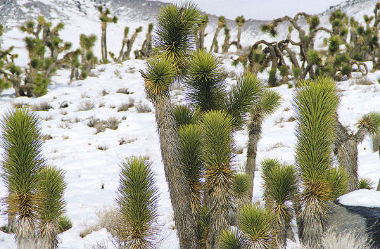
Environmental degradation in the US’s deserts: the Mojave
Just thinking about Joshua trees, as one does, since they were recently in the news since local National Parks staff couldn’t adequately monitor recreation use in the Mojave.
The 3 true deserts of North America are pretty ecologically sensitive. These deserts are used as playgrounds by recreationists (the Mojave); by the US military (the Sonoran); and by ranching industries (the Chihuahuan). In the midst of discussion of the federal US government shutdown’s effects on the Mojave Desert and Joshua trees, it’s worth noting just how unique and sensitive both the tree and the nearby desert ecology are. Regardless of the recent US federal employee furlough’s effects on land management, Joshua trees are already bound for local extinctions, due to soil degradation, climate change, urban growth, and US military shenanigans.
Here are some examples of the Joshua tree (Yucca brevifolia) featuring in national headlines lately, in the context of the shutdown:


-
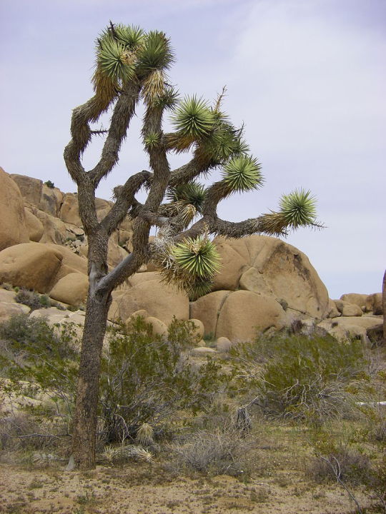
Joshua trees as an emblem of the Mojave Desert:
I’m not a botanist! Ask a botanist for better info about the Joshua tree’s physiology and ecology.
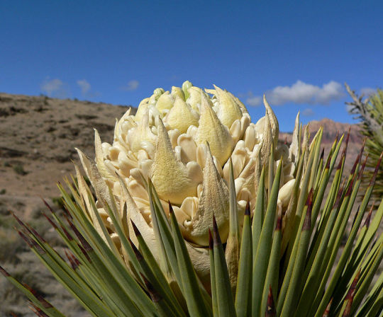
But, put generally, the Joshua tree is a strange plant with an ancient lineage, and they are an iconic endemic species representative of the unique Mojave Desert ecoregion. They can grow to about 14 meters in height; live for several hundred years; have large flowers and odd fruit; and give the desert landscape an alien-planet-looking vibe.
(Source 1; 2; 3)
-
If you’ve been to Joshua Tree National Park, you’ll know that educational literature and interpretive signs love to play-up the fact that the administrative boundaries of the park straddle the border between 2 dramatically different deserts: the Mojave Desert and the Sonoran Desert.
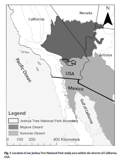
(Source.)
The national park, then, harbors the ecology of 2 of the 3 true deserts of North America. (The other, 3rd North American true desert is the Chihuahuan Desert of Chihuahua, New Mexico, and Texas’s Trans-Pecos region)
The Joshua tree itself, however, is basically endemic to only the Mojave Desert (which is to say that it lives almost entirely within the Mojave, with only the occasional sporadic existence outside of the Mojave in isolated spots in the northern Sonoran Desert).
The species is an emblem of the Mojave Desert. Compare the Joshua tree’s current distribution (on right) with the ecological boundaries of the Mojave Desert (on left).
(Mojave Desert map from here.)
-
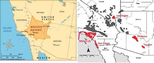
Urban population growth and Joshua trees:
The titular national park essentially functions as the backyard of the US’s “second city”: Los Angeles. The park is easily accessible as a day-trip from any part of LA.
San Diego and Las Vegas can easily access the park as well.
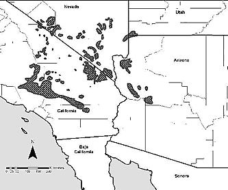
Here’s a closer look at the distribution range of Joshua trees:

Cross-hatched areas are current distribution of Joshua tree. Triangles are fossilized preserves of prehistoric (early Holocene) distribution. Red areas are heavily urbanized areas with a combined population of 31 million people. (Map originally from this study of Joshua tree phylogeography; labels added by me.)
I think it’s not discussed often enough that the “wilderness” of some major national parks in the contiguous US is sometimes so overrun that they become de facto domesticated recreation centers for nearby major urban areas.
- Everglades National Park sits directly alongside 6 million people in Greater Miami
- Mt. Rainier National Park is situated halfway between 4 million in the Seattle-Tacoma urban area and another 3 million in the Portland urban area
- Great Smokey Mountains sits right against 1 million or so people in Knoxville, Asheville, and Chattanooga while also seeing tourists from nearby Atlanta and Charlotte
In the case of Joshua Tree National Park:
LA (#2), Phoenix (#13), and San Diego (#18) are all in the top 20 most populous US urban areas. Phoenix is among the top 10 the fastest-growing major US urban areas, and Las Vegas isn’t far behind in rate of population growth.
The Mojave is becoming even more of a recreational playground. The range of the Joshua tree is immediately surrounded by these urban areas with a combined population of 31 million people or more.
The US military also wastes an egregious amount of space in the Mojave and Sonoran Deserts, under the lazy pretext that the deserts are empty and not intrinsically valuable, despite the extraordinary biodiversity of the Sonoran Desert between Mexicali and Nogales especially (including iconic, geographically-isolated species like rosy boas; gila monster; saguaro; Joshua tree; native desert palm species; etc.). Much of the Arizona-Mexico border is cordoned-off and wasted on military training space, despite its incredible ecological distinction.
-
Climate/ecological crisis effects of Joshua tree:
Lead author Dr. Ken Cole, of the Colorado Plateau Research Station in Flagstaff, in a 2005 report, provided some maps that predict the near-future range contraction that will be suffered by Joshua trees.
Here’s what the distribution range of the Joshua tree looks like now ...
... compared to what the distribution range of the Joshua tree should like in 25 years, in the very best-case scenario.
This projection of future Joshua tree distribution has been criticized for being inaccurate due to being “markedly optimistic” because this successful continued existence was projected based on the assumption that Joshua trees can be 10-times more successful at seed dispersal than they really are in the wild.
This projection was also made before the great climate science of the past 15 years fully revealed just how much worse the ecological collapse will probably be compared to earlier projections.
Again, I’m not a botanist! But the apparent trend here is: This range contraction will mean that Joshua trees - already limited to the Mojave Desert alone - will disappear from a majority of the Mojave.
-
Adding to the ecological uniqueness of the area, Joshua Tree National Park doesn’t just sit at the intersection of the Mojave Desert and Sonoran Desert ecoregions, but it also rests against another ecological boundary with the Mediterranean chaparral and Baja peninsular island mountain range ecology of the southern California coastline. This mild and unique coastal Californian ecology has its own set of many endemic species with small and isolated distribution ranges. This landscape, of course, is also in jeopardy, since the majority of this ecology - only really existing between roughly San Francisco Bay and Tijuana - has already been consumed by California’s human development.
-
Anyway. Deserts are not featureless wastelands. Joshua trees are just one of many other comparably unique, exemplary, or charismatic plants and animals with narrow, endemic distribution ranges in the North American deserts.
14 notes
·
View notes
Photo

KEVIN MARTY interview in DESTIG Magazine
Tell us about yourself and background.
I am from Seattle, WA, and currently live in Southern California with my wife and 3-year-old son. I finished my MFA in Photography through the Savannah College of Art and Design during 2017. I also earned my M.S. in Geology during 1994 at the University of New Orleans, and B.S. in Geology during 1991 at Central Washington University (in Washington State).
For the past 14 years I have worked as a geology professor at a community college in Southern California. Prior to that I worked federal government jobs and as a photojournalist in Southern California.
Tell us about your work.
For my MFA thesis work, I created images using two of the oldest photographic printing methods: salt prints and cyanotypes. I aimed to show the intersection of science and art; the balance of chemicals, water and light that are central to both photography and the sustenance of life.
The subject for my thesis work is the Salton Sea, California’s largest lake that is degrading and evaporating away from drought, water transfers and neglect.
I strive to capture the beauty and complexity of this place-its fleeting moments and the traces of accelerated entropy-to show what is lost to time. The salt prints reference preservation, and the process itself is a literal nod to the chemical composition of the sea and signifies its remains or trace as evaporation lowers sea level and exposes crystalline shorelines. Unpredictable spotting signifies deterioration from the human touch* and links the sea to the lab and art to science. The cyanotype photograms (showing, for example, bones and feathers of dead birds and fish that litter the shoreline) document trace “fossils” and reveal blueprints that function as visual remainders. For my most recent work I create very large (Giclee) prints- some 15-20 feet wide- using a 36 megapixel Nikon D810 to create panoramas with excellent detail, and stitch them together with Photoshop. The dominant subject of these prints is landscapes/seascapes. Prior to my MFA work, I created many images while working as a photojournalist. I used a mixture of film and digital cameras, traditional darkroom and Photoshop methods, to complete my assignments. In general, my work is about investigating the natural world for its beauty and meaning in our lives.*The Salton Sea is a mistake, formed when a levy burst along the Colorado River over 100 years ago.
What makes your work and approach unique?
For my MFA work, it’s an approach used by the first photographers who found a way to fix an image on paper and create the first negatives; it is uncommon for photographers to use these methods today. In a world saturated with images from a wide variety of devices, I take a few steps back to the darkroom, and to camera-less prints when I make photograms. There is satisfaction in being involved in every step of the process to create a very unique print. While I do create digital negatives, there is technique involved in creating the optimum contrast/density of these negatives for the “printing-out” process. I brush the chemicals such as salt solution and silver nitrate on watercolour paper and together with the digital negative, expose it to sunlight and burn in the image that is then developed and fixed in the darkroom for a print. Also for my MFA work and current work I create very large (Giclee) prints as described above. My approach is one of investigation and inquiry; passion and inspiration; science and art: I observe and sometimes intervene with natural processes and features, and nature will reveal itself and do everything but push the shutter of my next photograph.
Why is your work a good investment?
The process to create salt prints and cyanotypes produce nice archival quality prints that create a historical or nostalgic quality whether the print is made today or is a couple centuries old (I can apply these methods to a client’s digital images if requested although the quality would depend on the original image and file size). The large Giclee prints, including panoramas, are very detailed and excellent archival quality. While the Giclee/digital and film prints are relatively easy to reproduce (but can be limited to a series), the salt prints/cyanotypes are one of a kind.
Tell us about some of your achievements.
Completed my MFA in Photography, 2017 (Savannah College of Art and Design); thesis show at a gallery (Tiendique) in El Centro, Ca (2017); exhibition during 2018 at the Juanita Salazar Lowe Art Gallery, Imperial Valley College, Imperial CA; Showed work during 2016 at the Maryland Federation of Art Circle Gallery.
For my work as a photojournalist, several images were published in magazines and major newspapers (such as Popular Science; Christian Science Monitor and Los Angeles Times). Many images picked up on the Associated Press wire and used by media.
What are your sources of inspiration?
The landscape photography of Ansel Adams and Galen Rowell were my early inspiration. Later, and through my MFA work, I became inspired by the Earth Art Movement and conceptual photography of the 60s and 70s. The Earth art, for example, of Robert Smithson, Michael Heizer and Andy Goldsworthy- I love their style of intervening with nature, or recreating it for their idea of how is should or could be. My cyanotype work is inspired by the work of Botanist Anna Atkins.
I am also inspired by the work of Susan Derges who creates photograms of river water (by submerging the printing paper). The natural world is my overall inspiration. Geology and art inspire me to experiment and produce work emphasizing the art in science (or the science in art). Landscapes/ seascapes have their natural beauty from the interactions of solids, liquids and gases through forces of continual change. The consequences of these forces, such as mountains and weather, are captured at various moments of construction and destruction; of renewal and entropy. I am inspired to investigate this with my camera and inquire into the meaning of these moments for a better understanding of our world.
What you are passionate about?
I am passionate about hiking, backpacking, and the light of storms; the struggle at the Salton Sea, hidden lakes of the Sierra Nevada Mountains, the desolation of Death Valley and tectonics of the Pacific Northwest. I like the view from the trail and backroads. I am not an environmentalist per se, but believe in many environmental causes and preservation of national parks. I also believe in altering the land- scape through the Earth work interventions of artists such as Smithson, Heizer and Goldsworthy; and through the science of mining to extract energy and mineral resources while exposing episodes of the Earth’s history.
I am also passionate about social programs in place to help people; that everyone is equal and should be treated that way.
Share with us your upcoming projects.
I am continuing my work on creating very large prints using panoramic techniques on a variety of themes, mostly related to nature.
Tell us about where you are based.
I am currently based in Imperial Valley, CA, about 100 miles east of San Diego, Ca., and in the rain shadow of the Peninsular Ranges. The latitude and mountains create a harsh desert environment where temperatures are over 100 degrees for several months of the year. Features here include California’s largest lake (the Salton Sea); the Imperial Sand Dunes (the location of much filming); numerous desert ranges; a large gold mine and geothermal plants.
Southern California’s light can be amazing!
More images from this interview: https://www.destig.com/marty.html
Website: kevinmartyphotography.artspan.com
0 notes
Photo

Baja California Sur in all it’s beauty. Clearly visible the Sierra de la Laguna is a mountain range at the southern end of the Baja California Peninsula in Mexico, and is the southernmost range of the Peninsular Ranges System. It is located in La Paz Municipality and Los Cabos Municipality of southern Baja California Sur state.
The "Sierra de la Laguna High Point", at 6,857 feet (2,090 m) in elevation, is the highest point of the range and in Baja California Sur state.
2 notes
·
View notes
Text
New Post has been published on Attendantdesign
New Post has been published on https://attendantdesign.com/incessant-rain-displaces-thousands-in-terai/
Incessant rain displaces thousands in Terai
Floods resulting from incessant rain have created havoc throughout the low-mendacity Terai vicinity in Nepal, inundating hundreds of homes and displacing humans, the media pronounced on Saturday.
The floods on the grounds that Friday night time has forced thousands of families to shift to shelters and damaged belongings, cattle, farm animals and plants, Xinhua news company reported.
The water level in many rivers has crossed the hazard mark and modified their direction, with a chance to houses and livelihood.
The scenario remained disturbing on Saturday along the basins of important rivers like Saptakoshi, Kankai, Babai, Rapti, and Mohana.
The floods have created havoc in districts like Banke, Bardiya, Dhanusa, Saptari, Siraha, Sunsari and Morang name the hill ranges that forms a rift valley in the peninsular plateau .
Saptari has been affected the maximum considering the fact that the beginning of the monsoon, leaving hundreds of households displaced.
According to police, six people died in Itahari city on Saturday morning. Electricity has been cut off in the city and vehicular motion disrupted after water entered the principal streets.
Deaths have also been suggested from other districts together with Sindhuli and Banke. A reputable stated the authorities changed into yet to verify the whole variety of deaths and the quantity of the damage.
The Flood Forecasting Division of the Department of Hydrology and Meteorology on Friday positioned areas near primary drivers on high alert for the next 24 hours.
The Home Ministry has instructed the authorities to heighten rescue efforts inside the flood-affected settlements in Terai place, a reliable said.
Meanwhile, the Meteorological Forecasting Division has forecast moderate to heavy rain for the next few Updated Date: Aug 12, 2017, 05:09 pm
Tags :#Nepal#Nepal floods#Newstracker#Rainfall#Terai place
Also See
600 travelers, along with 2 hundred Indians, stranded by means of floods in Nepal’s Sauraha village
Nepal floods: At least 25 feared killed in landslides, deluge in forty-eight hours bhabar terai
Nepal floods: 36 killed, 12 missing, masses displaced due to landslides, torrential Terai displaces rain
In need of divine justice? Head to Kerala’s ‘Judge Uncle’ shrine
Teams were nonetheless working to easy different elements of the spill and coastal areas, he said.
Emergency groups have been struggling with the massive oil spill since it appeared off the emirate’s southern coast on Thursday.
Sheikh Talal stated precautionary measures have been taken around vital installations in Al-Zour place wherein a big USD 30-billion oil complex which includes a 6,15,000-barrel-per-day refinery is being built.
There were no reputable reviews approximately the source or size of the spill within the waters near the Al-Khafji subject.
However, Kuwaiti media on Sunday quoted nearby oil professionals as pronouncing the spill originated from a vintage 50-kilometre pipeline from Al-Khafji.
The experts envisioned that as many as 35,000 barrels of crude may additionally have leaked into the waters off Al-Zour.
Emergency teams have sealed off energy and water desalination flora within the area to prevent infection.
Kuwait relies upon largely on desalination for its fresh water supplies.
Saudi Arabia and Bahrain, located south of Kuwait along the Gulf coast, stated slicks from the spill had now not reached their waters.
Saudi Arabia, in a statement published by the reliable SPA news company, said it had applied a “disaster control plan” and turned into conducting an aerial survey of its oil installations along the coast.
The KPC stated groups from Saudi Arabian Chevron and Oil Spill Response Limited (OSRL) had joined the coastal cleanup.
OPEC member Kuwait pumps around 2.7 million barrels in keeping with the day of crude oil, offering round 85 consistent with the cent of its public revenues.
“Fiduciary” is basically defined by Black’s Law Dictionary as a term derived from a Roman law which means, as a noun, a person or legal entity, holding the character of a trustee, with respect to the trust and confidence involved as scrupulous good-faith and candor towards another’s affairs. A fiduciary also has duties which are described as involving good-faith, trust, special confidence, and candor toward another’s interests. Typical fiduciary duties are imposed on and include such relationships as executor, administrator, trustee, real estate agents, attorneys, and, of course, property managers. A person or company who manages money or property, i.e., the manager, for other people must exercise a standard of care in that the interests of the money or property owners are placed above and beyond those of the property manager. In some states, like California for example, a property manager is statutorily defined as an individual or entity which has the same duties as a trustee, i.e., a fiduciary.
The way I always explain it to clients, using my hands to demonstrate, is that my interests and at the top of my head (one hand at the crown of my head), but the client’s interest rise above and beyond my head and take precedence over my own (holding both of my hands above my head in a clasped position). Most people understand the gesture and comprehend that as a property manager and a lawyer my interests are much lower than those of the clients in our relationship.
Common Fiduciary Duties Owed by Property Managers
Since a property manager is a fiduciary they must act with the highest good-faith and fair dealing with respect to the owner’s asset, disclose all material information that may affect the owner’s decision-making with respect to that asset, and can’t in any way, shape or form act adversely to the owner’s interests. This may sound easy, but there are situations that arise that tempt even the best property managers to sometimes not act in their client’s best interests to suit their own self-interested convenience. Unfortunate as that may sound it happens regularly.
The following is a short list of some common sense duties, rights, and wrongs when a fiduciary relationship exists between a manager and an owner.
A manager should have a written agreement with their clients and may even be legally entitled to profit from services for which they provide to the owner, however, a manager may not secretly profit from this relationship. For example, a manager may charge an eight percent markup on materials and services provided by vendors to the owner’s property. This is legal and acceptable provided that the agreement between the parties is in concert with the markup. If this markup was not in the agreement then the law requires a property manager to disgorge or relinquish any and all secret profits derived from the relationship. There are so many possible examples of this, but a common one is a manager making a percentage profit on work and services provided to their clients but not disclosed; like a new roof, bathroom remodels, repairs to interior walls, etc.
A property manager is required to disclose any and all rental offers received along with documentation of those offers such that the property owner is well informed about all potential tenants. It is easy for a manager to fail to provide names of potential tenants that don’t necessarily qualify or are poor credit risks as this would involve more work for the manager.
A property manager is statutorily required to act for the sole benefit of the asset owner in matters that evolve from the relationship, whether or not those matters are seemingly insignificant or they are significantly material.
Information about a tenant who falls behind on their rent must be immediately communicated to the asset owner. If your management company is using a software system that allows an “Owner Portal” then this information is readily available to see and anytime one has access to the internet.
0 notes
Text
California’s Monumental Distress
Seven of California’s national monuments are under “review” as a result of President Trump’s executive order leveling an all-out assault on our public lands.
In April, the Carrizo Plain National Monument, located in a remote area east of San Luis Obispo, California, erupted with wildflowers in an occasional event known as a “super bloom.” Bob Wick, with the Bureau of Land Management, wrote on the agency’s Flickr page that “(t)he Valley floor has endless expanses of yellows and purples from coreopsis, tidy tips and phacelia, with smaller patches of dozens of other species … (And) the Temblor Range is painted with swaths of orange, yellow and purple like something out of a storybook. I have never seen such a spectacular array of blooms. Ever.”
The Carrizo Plain National Monument is one of seven California national monuments under review by the U.S. Department of the Interior to determine if they should remain as designated, or if their boundaries or management should be changed by the federal government. This unprecedented review, ordered by President Trump, affects 27 national monuments designated under the Antiquities Act of 1906.
California’s seven national monuments under review are special places and must remain protected. These areas were designated after years of community-based organizing, extensive effort to detail the specific historical, cultural and ecological values that make these areas meet the strict criteria for monument designation, and broad public outreach efforts. These lands receive overwhelming public support from the local community and stakeholders. After monument designation, collaborative efforts continue with the monument management planning process involving all stakeholders, particularly the local communities around the monuments.
In California, the president’s Executive Order affects seven national monuments—the most of any state with monuments under review. These seven monuments are widely supported by both Californians and most Americans. Many include lands sacred to Native American Tribes or capture historic locales celebrating our American legacy. Others provide invaluable cultural, scientific and recreational resources that provide immeasurable social, economic and ecosystem protection benefits to local communities. These monuments provide habitat for some of California’s most iconic wildlife, including the California condor, desert tortoise, and San Joaquin kit fox. They are places for both Americans and global visitors to reconnect with nature and recreate.
The Berryessa Snow Mountain National Monument is located in California’s Inner Coast Range. It is the best place in the world to see and understand plate tectonics and lies at the intersection of the Bay Area and the Klamath-Siskiyou regions—two incredibly diverse ecosystems. The designation preserves a rich Native American cultural history, dating back at least 12,000 years. It offers a wealth of recreational opportunities and has become an important economic engine for many small rural communities in the region. By the time of its designation in 2015, the monument was supported by nearby cities and counties, 200 businesses, 60 elected officials, the conservation community, local ranchers and farmers, faith-based organizations, regional Hispanic communities, and local Native American Tribes.
Berryessa Snow Mountain
The Mojave Trails and Sand to Snow national monuments stretch along a portion of historic Route 66 and connect Joshua Tree National Park and the San Bernardino National Forest. These monuments were supported by state and local elected officials, business owners, veterans, local faith leaders, anglers, historians, and conservationists. Mojave Trails National Monument, California’s largest national monument, incorporates the historic Mojave Trail, which connects the Colorado River with the California Coast and was trekked by Native Americans for centuries. Franciscan Father Garces discovered this trail in 1776, and pioneering trailblazer Jedidiah Smith followed his footsteps through Afton Canyon, or the “Grand Canyon the Mojave” in 1826. The Los Angeles to Salt Lake Railroad, a brainchild of United States Senator William Andrews Clark constructed in 1905; and the Tonopah to Tidewater Railroad, constructed in 1907 by “Borax King” Francis Marion Smith, are also partially encompassed in this national monument. It also stretches along a portion of historic Route 66, also known as the “Main Street of America” or the “Mother Road”, which was one of the original roadways of the United States Highway System.
Mojave Trails
The Sand to Snow National Monument stretches from the sands of both the Mojave and Colorado deserts to San Gorgonio Peak, the tallest mountain in southern California. It connects a vital wildlife corridor between mountains considered sacred by the Gabrielino, Luiseno and Serrano Indian Tribes. Thirty miles of the Pacific Crest Trail bisect this monument, which supports more than 1,600 plant species dispersed throughout diverse niches between mountain peaks and the desert floor. The monument serves to connect the western portions of the San Bernardino National Forest, San Gorgonio Wilderness, Big Morongo, Whitewater and Mission Creek Preserves, Black Lava Butte and Flat Top Mesa to Joshua Tree National Park.
These California Desert monuments were supported by a wide range of state and local elected officials, business owners, veterans, local faith leaders, anglers, historians, and conservationists. Extensive planning to address local concerns spanned nearly a decade preceding monument designation.
Sand to Snow
Both Mojave and Sand to Snow monuments provide essential habitat for well-known wildlife such as the threatened Agassiz’s desert tortoise, California’s state reptile; the endangered peninsular bighorn sheep and closely-related desert bighorn sheep; wide-ranging vulnerable species such the golden eagle; as well as fascinating endemic species, such Coachella Valley and Mojave fringed-toed lizards. Archeological, historic and scientific wonders include the Marble Mountains Fossil Beds, where 550-million-year-old trilobite fossils can be found; the volcanic Pisgah Lava Flow and Amboy Crater National Landmark; the Bigelow Cholla Garden, California’s largest cactus assemblage; General Patton’s World War II Tank Training Camp; and the singing Cadiz Sand Dunes.
The San Gabriel Mountains National Monument, located just a 90-minute drive from the park-poor Los Angeles Basin, offers vast expanses of largely undeveloped forest and alpine landscape, four wilderness areas, streams and rivers with incredible opportunities for fishing, picnicking, and camping Its mountain streams and forests serve as a critical watershed for Southern California cities and are an important part of the hunting and fishing industry, with more than 100 hunting and fishing organizations opposing any reduction in monument protection or size. Most of the San Gabriel’s major mountain peaks are located within the monument, including Mount San Antonio and Mount Baden-Powell, as well as the striking geological features of the San Andreas Fault and Devil’s Punchbowl. The monument’s diverse habitats support imperiled species such as the endangered California condor, southwestern willow flycatcher, mountain yellow-legged frog and Santa Ana sucker, as well as the California spotted owl, mountain lion, black bear and desert bighorn sheep.
San Gabriel Mountains
The Carrizo Plain National Monument protects some of the last remaining intact native grassland in Central California. A land of waving grass and wildflower “super blooms,” it is home to several animals of significant conservation importance such as pronghorn antelope, which has been extirpated in much of California; tule elk, a unique subspecies once wiped out in the state and which has recovered from a single breeding pair; and both the endangered San Joaquin kit fox, and the world’s largest bird, the California condor.
Carrizo Plain
Giant Sequoia National Monument boasts half of all the giant sequoias in the world, including 38 of 39 groves in Sequoia National Forest. Thousands of families visit these lands each year to marvel at the largest living organisms on Earth which have spanned the centuries; some to ages of 3,000 years or more. This ancient forest supports the imperiled Pacific fisher and California spotted owl, as well as mountain lion, bobcat and black bear; with the southern portion of the monument partially surrounding the Tule River Indian Reservation.
Giant Sequoia
One of the most biologically diverse ecosystems of the Cascade Range, the Cascade-Siskiyou National Monument straddles the border between California and Oregon where the Klamath, Siskiyou, and Cascade mountain ranges converge, setting the stage for a unique mixing of diverse habitats in a small area. An intriguing mosaic of grasslands, oak woodlands, juniper scrub, chaparral, dry pine forest, moist fir forest, meadows, wetlands and volcanic rock outcrops support the endangered Gentner’s fritillary and great gray owl, the threatened northern spotted owl, Oregon spotted and yellow-legged frogs, redband trout, Roosevelt elk, American pika and more here. The historic Applegate Trail and California branch of the Oregon Trail are also encompassed by this monument, which was supported by local communities, businesses, Native American Tribes, conservation organizations, hunting and fishing groups.
Cascade-Siskiyou
California Strong
These seven monuments represent the best of California’s wildlife and wild places and are broadly supported. Mirroring the strong public support for continued protection of these monuments in California, the state Legislature passed Assembly Joint Resolution 15 in June. This resolution called on Congress and the president to respect and protect California’s seven monuments currently under review. Interior Secretary Ryan Zinke should listen to the wishes of the overwhelming majority of Californians and people throughout the country who love their national monuments and want them to remain intact and protected for future generations.
Help us speak up for our wildlife and wild places. Tell Secretary Zinke that America’s national monuments belong to all of us and should be preserved as designated under the Antiquities Act!
Download our California monuments print-out and our 27 monuments print-out to help us spread the word about this potentially disastrous attack on our cherished wild places and the wildlife that call these places home.
Follow us on social media to stay up-to-date on the status of these at-risk national monuments and other developments important to wildlife conservation and our work. Don’t forget to sign up for our emails where you will get all the latest news and action alerts to support wildlife.
The post California’s Monumental Distress appeared first on Defenders of Wildlife Blog.
from Defenders of Wildlife Blog http://ift.tt/2t6hZsL
via IFTTT
0 notes
Text
Dhaan Diwash ko Subhakamana, 15th Ashar
#Dhaan Diwash ko Subhakamana, 15th Ashar ..................Paddy field........... "Wet rice" redirects here. For the porridge dish, see Congee. "Rice field" redirects here. For the Rice University stadium in Houston, see Rice Track/Soccer Stadium. Traditional planting in northwestern Iran A paddy field is a flooded parcel of arable land used for growing semiaquatic rice. Paddy cultivation should not be confused with cultivation of deep water rice, which is grown in flooded conditions with water more than 50 cm (20 in) deep for at least a month. Genetic evidence shows that all forms of paddy rice, both indica and japonica, spring from a domestication of the wild rice Oryza rufipogon that first occurred 8,200–13,500 years ago South of the Yangtze River in present-day China.[1] However, the domesticated indica subspecies currently appears to be a product of the introgression of favorable alleles from japonica at a later date, so that there are possibly several events of cultivation and domestication.[2] Paddy fields are the typical feature of rice farming in east, south and southeast Asia. Fields can be built into steep hillsides as terraces and adjacent to depressed or steeply sloped features such as rivers or marshes. They can require a great deal of labor and materials to create, and need large quantities of water for irrigation. Oxen and water buffalo, adapted for life in wetlands, are important working animals used extensively in paddy field farming. During the 20th century, paddy-field farming became the dominant form of growing rice. Hill tribes of Thailand still cultivate dry-soil varieties called upland rice.[3] Paddy field farming is practiced in Cambodia, Bangladesh, China, Taiwan, India, Indonesia, Iran, Japan, North Korea, South Korea, Malaysia, Myanmar, Nepal, Pakistan, the Philippines, Sri Lanka, Thailand, Vietnam, and Laos, Northern Italy, the Camargue in France,[4] the Artibonite Valley in Haiti, and Sacramento Valley in California. Paddy fields are a major source of atmospheric methane and have been estimated to contribute in the range of 50 to 100 million tonnes of the gas per annum.[5][6] Studies have shown that this can be significantly reduced while also boosting crop yield by draining the paddies to allow the soil to aerate to interrupt methane production.[7] Studies have also shown the variability in assessment of methane emission using local, regional and global factors and calling for better inventorisation based on micro level data.[8] The word "paddy" is derived from the Malay word padi, rice plant.[9] History Paddy and Hay in Mysore, India China Edit Rice paddies near Beijing in 1920 Archaeologists generally accept that wet-field cultivation originated in China. The earliest paddy field found, dates to 4330 BC, based on carbon dating of grains of rice and soil organic matter found at the Chaodun site in Kunshan County.[10] At Caoxieshan, a site of the Neolithic Majiabang culture, archaeologists excavated paddy fields.[11] Some archaeologists claim that Caoxieshan may date to 4000–3000 BC.[12][13] There is archaeological evidence, that unhusked rice was stored for the military and for burial with the deceased, from the Neolithic period to the Han Dynasty in China.[14] Korea There are ten archaeologically excavated rice paddy fields in Korea. The two oldest are the Okhyun and Yaumdong sites, found in Ulsan, dating to the early Mumun pottery period.[15] Paddy field farming goes back thousands of years in Korea. A pit-house at the Daecheon-ni site yielded carbonized rice grains and radiocarbon dates, indicating that rice cultivation in dry-fields may have begun as early as the Middle Jeulmun Pottery Period (c. 3500–2000 BC) in the Korean Peninsula.[16] Ancient paddy fields have been carefully unearthed in Korea by institutes such as Kyungnam University Museum (KUM) of Masan. They excavated paddy field features at the Geumcheon-ni Site near Miryang, South Gyeongsang Province. The paddy field feature was found next to a pit-house that is dated to the latter part of the Early Mumun Pottery Period (c. 1100–850 BC). KUM has conducted excavations, that have revealed similarly dated paddy field features, at Yaeum-dong and Okhyeon, in modern-day Ulsan.[17] The earliest Mumun features were usually located in low-lying narrow gullies, that were naturally swampy and fed by the local stream system. Some Mumun paddy fields in flat areas were made of a series of squares and rectangles, separated by bunds approximately 10 cm in height, while terraced paddy fields consisted of long irregular shapes that followed natural contours of the land at various levels.[18][19] Mumun Period rice farmers used all of the elements that are present in today's paddy fields, such as terracing, bunds, canals, and small reservoirs. We can grasp some paddy-field farming techniques of the Middle Mumun (c. 850–550 BC), from the well-preserved wooden tools excavated from archaeological rice fields at the Majeon-ni Site. However, iron tools for paddy-field farming were not introduced until sometime after 200 BC. The spatial scale of paddy-fields increased, with the regular use of iron tools, in the Three Kingdoms of Korea Period (c. AD 300/400-668). Japan The first paddy fields in Japan date to the Early Yayoi period [300 BC – 250 AD].[20] The Early Yayoi has been re-dated, and it appears that wet-field agriculture developed at approximately the same time as in the Korean peninsula.[citation needed] Philippines In the Philippines, the use of rice paddies can be traced to prehistoric times, as evidenced in the names of towns such as Pila, Laguna, whose name can be traced to the straight mounds of dirt that form the boundaries of the rice paddy, or "Pilapil."[21] Vietnam Wet rice cultivation in Vietnam dates back to the Neolithic Hoa Binh culture and Bac Son culture.[22] Culture Top 20 rice producers by country—2012 (million metric ton)[23] China 204.3 India 152.6 Indonesia 69.0 Vietnam 43.7 Thailand 37.8 Bangladesh 33.9 Myanmar 33.0 Philippines 18.0 Brazil 11.5 Japan 10.7 Pakistan 9.4 Cambodia 9.3 United States 9.0 Korea 6.4 Egypt 5.9 Nepal 5.1 Nigeria 4.8 Madagascar 4.0 Sri Lanka 3.8 Laos 3.5 Source: Food and Agriculture Organization Panorama of the Longji terrace, one of the Longsheng rice terraces of Guangxi, China Although China's agricultural output is the largest in the world, only about 15% of its total land area can be cultivated. About 75% of the cultivated area is used for food crops. Rice is China's most important crop, raised on about 25% of the cultivated area. Most rice is grown south of the Huai River, in the Yangtze valley, the Zhu Jiang delta, and in Yunnan, Guizhou, and Sichuan provinces. Rice appears to have been used by the Early Neolithic populations of Lijiacun and Yunchanyan in China.[24] Evidence of possible rice cultivation from ca. 11,500 BP has been found, however it is still questioned whether the rice was indeed being cultivated, or instead being gathered as wild rice.[25] Bruce Smith, an archaeologist at the Smithsonian Institution in Washington, D.C., who has written on the origins of agriculture, says that evidence has been mounting that the Yangtze was probably the site of the earliest rice cultivation.[26] In 1998, Crawford & Shen reported that the earliest of 14 AMS or radiocarbon dates on rice from at least nine Early to Middle Neolithic sites is no older than 7000 BC, that rice from the Hemudu and Luojiajiao sites indicates that rice domestication likely began before 5000 BC, but that most sites in China from which rice remains have been recovered are younger than 5000 BC.[24] During the Spring and Autumn Period (722–481 BC), two revolutionary improvements in farming technology took place. One was the use of cast iron tools and beasts of burden to pull plows, and the other was the large-scale harnessing of rivers and development of water conservation projects. Sunshu Ao of the 6th century BC and Ximen Bao of the 5th century BC are two of the earliest hydraulic engineers from China, and their works were focused upon improving irrigation systems.[27] These developments were widely spread during the ensuing Warring States period (403–221 BC), culminating in the enormous Du Jiang Yan Irrigation System engineered by Li Bing by 256 BC for the State of Qin in ancient Sichuan. During the Eastern Jin (317–420) and the Northern and Southern Dynasties (420–589), land-use became more intensive and efficient, rice was grown twice a year and cattle began to be used for plowing and fertilization. In circa 750, 75% of China's population lived north of the river Yangtse, but by 1250, 75% of China's population lived south of the river Yangtse. Such large-scale internal migration was possible due to introduction of quick-ripening strains of rice from Vietnam suitable for multi-cropping.[28] Localities in China which are famous for their spectacular rice paddies are Yuanyang County, Yunnan, and Longsheng County, Guangxi. India Paddy fields prior to planting in Andhra Pradesh, India India has the largest paddy output in the world and is also the fourth largest exporter of rice in the world. In India, West Bengal is the largest rice producing state.[29] Paddy fields are a common sight throughout India, both in the northern gangetic plains and the southern peninsular plateaus. Paddy is cultivated at least twice a year in most parts of India, the two seasons being known as Rabi and Kharif respectively. The former cultivation is dependent on irrigation, while the latter depends on Monsoon. The paddy cultivation plays a major role in socio-cultural life of rural India. Many festivals such as Onam in Kerala, Bihu in Assam, Sankranthi in Andhra Pradesh, Thai Pongal In Tamil Nadu, Makar Sankranti in Karnataka, Nabanna in West Bengal celebrates harvest of Paddy. Kaveri delta region of Thanjavur is historically known as the rice bowl of Tamil Nadu and Kuttanadu is called the rice bowl of Kerala. Indonesia Water buffalos were formerly used to plough muddy paddy fields in Indonesia although the use of mechanised methods, such as small powered ploughs, has become much more common in recent years. Prime Javanese paddy yields roughly 6 metric tons of unmilled rice (2.5 metric tons of milled rice) per hectare. When irrigation is available, rice farmers typically plant Green Revolution rice varieties allowing three growing seasons per year. Since fertilizer and pesticide are relatively expensive inputs, farmers typically plant seeds in a very small plot. Three weeks following germination, the 6–8 inch stalks are picked and replanted at greater separation, in a backbreaking manual procedure. Rice harvesting in Central Java is often performed not by owners or sharecroppers of paddy, but rather by itinerant middlemen, whose small firms specialize in harvesting, transport, milling, and distribution to markets. The fertile volcanic soil of much of the Indonesian archipelago—and particularly the islands of Java and Bali—has made rice a central dietary staple. Steep terrain on Bali resulted in an intricate cooperation systems, locally called subak, to manage water storage and drainage for rice terraces.[30] Italy Paddy fields near Mantua Rice is grown in northern Italy, especially in the valley of the river Po.[31] The paddy fields are irrigated by fast-flowing streams descending from the Alps. Japan Paddy field scarecrows in Japan The acidic soil conditions common in Japan due to volcanic eruptions have made the paddy field the most productive farming method. Paddy fields are represented by the kanji 田 (commonly read as ta) that has had a strong influence on Japanese culture. In fact, the character 田, which originally meant 'field' in general, is used in Japan exclusively to convey the meaning 'rice paddy field'. One of the oldest samples of writing in Japan is widely credited to the kanji 田 found on pottery at the archaeological site of Matsusaka, Mie that dates to the late 2nd century. Ta (田) is used as a part of many place names as well as in many family names. Most of these places are somehow related to the paddy field and in many cases, are based on the history of a particular location. For example, where a river runs through a village, the place east of river may be called Higashida (東田), literally "east paddy field." A place with a newly irrigated paddy field, especially those during or later than Edo period, may be called Nitta or Shinden (both 新田), "new paddy field." In some places, lakes and marshes were likened to a paddy field and were named with ta, like Hakkōda (八甲田). Today, many family names have ta as a component, a practice which can be largely attributed to a government edict in the early Meiji Period which required all citizens to have a family name. Many chose a name based on some geographical feature associated with their residence or occupation, and as nearly three fourths of the population were farmers, many made family names using ta. Some common examples are Tanaka (田中), literally meaning "in the paddy field;" Nakata (中田), "middle paddy field;" Kawada (川田), "river paddy field;" and Furuta (古田), "old paddy field." In recent years rice consumption in Japan has fallen and many rice farmers are increasingly elderly. The government has subsidized rice production since the 1970s, and favors protectionist policies regarding cheaper imported rice.[32] Korea Paddy field near Namwon, South Korea, early June Arable land in small alluvial flats of most rural river valleys in South Korea are dedicated to paddy-field farming. Farmers assess paddy fields for any necessary repairs in February. Fields may be rebuilt, and bund breaches are repaired. This work is carried out until mid-March, when warmer spring weather allows the farmer to buy or grow rice seedlings. They are transplanted (usually by rice transplanter) from the indoors into freshly flooded paddy fields in May. Farmers tend and weed their paddy fields through the summer until around the time of Chuseok, a traditional holiday held on 15 August of the Lunar Calendar (circa mid-September by Solar Calendar). The harvest begins in October. Coordinating the harvest can be challenging because many Korean farmers have small paddy fields in a number of locations around their villages, and modern harvesting machines are sometimes shared between extended family members. Farmers usually dry the harvested grains in the sun before bringing them to market. The Chinese (or Sino-Korean) character for 'field', jeon (Hangul: 전; hanja: 田), is found in some place names, especially small farming townships and villages. However, the specific Korean term for 'paddy' is a purely Korean word, "non" (Hangul: 논). Madagascar Baobab and rice field near Morondava, Madagascar In Madagascar, the average annual consumption of rice is 130 kg per person, one of the largest in the world. According to a 1999 study of UPDRS / FAO: The majority of rice is related to irrigation (1,054,381 ha). The choice of methods conditioning performance is determined by the variety and quality control of water .. The "Tavy", is traditionally the culture of flooded upland rice on burning of cleared natural rain forest (135,966 ha). Criticized as being the cause of deforestation, "Tavy" is still widely practiced by farmers in Madagascar, who find a good compromise between climate risks, availability of labour and food security. "Tanety" means hill. By extension, the "tanety" is also growing upland rice, carried out on the grassy slopes have been deforested for the operation of charcoal. (139,337 ha) Among the many varieties, rice of Madagascar include: "Vary lava" is a translucent long and large grain rice. It is a luxury ricer. "Vary Makalioka, is translucent long and thin grain rice. "Vary Rojofotsy" is a -half long.grain rice "Vary mena" or red rice, is exclusive to Madagascar. Malaysia Paddy field in the state of Terengganu, Malaysia Paddy field are typically found on Peninsular Malaysia, in most of its regions. The most scenic paddy fields are located in northern Malaysia, in Kedah, Perlis and Penang; almost covering these states. Paddy fields also can be found on Malaysia's eastern coast region, mainly in Kelantan and Terengganu, and also in Selangor, especially in the districts of Kuala Selangor and Sabak Bernam. Before Malaysia became heavily reliant on its industrial output, people were mainly involved in agriculture, especially in the production of rice. It was for that reason, that people usually built their houses next to paddy fields. The very spicy chili pepper that is often eaten in Malaysia, the bird's eye chili, is locally called cili padi, literally "paddy chili". Paddy Fields in Idukki, India Myanmar Rice is grown primarily in three areas – the Irrawaddy Delta, the area along and the delta of the Kaladan River, and the Central plains around Mandalay, though there has been an increase in rice farming in Shan State and Kachin State in recent years.[33] Up until the later 1960s, Myanmar was the main exporter of rice. Termed the rice basket of South East Asia, much of the rice grown in Myanmar does not rely on fertilizers and pesticides, thus, although "organic" in a sense, it has been unable to cope with population growth and other rice economies which utilized fertilizers. Rice is now grown in all the three seasons of Myanmar, though primarily in the Monsoon season – from June to October. Rice grown in the delta areas rely heavily on the river water and sedimented minerals from the northern mountains, whilst the rice grown in the central regions require irrigation from the Ayeryarwaddy River. The fields are tilled when the first rains arrive – traditionally measured at 40 days after Thingyan, the Burmese New Year – around the beginning of June. In modern times, tractors are used, but traditionally, buffalos were employed. The rice plants are planted in nurseries and then transplanted by hand into the prepared fields. The rice is then harvested in late November – "when the rice bends with age". Most of the rice planting and harvesting are done by hand. The rice is then threshed and stored, ready for the mills. Nepal Women planting rice in Nepal In Nepal, rice (Nepali: धान, Dhaan) is grown in the Terai and hilly regions. It is mainly grown during the summer monsoon in Nepal. Rice is the main Crop of Nepalese. So, Nepalese celebrates Dhaan Diwash (Paddy Day) on 15th Ashar according to Nepali calendar. Farmers are the first doctors of this World due to producer of Raw material to be alive life of Living organisms. FSC Rupandehi started to celebrate Natoinal Farmers Day on 27th jestha in Nepal. And, also announced to Celebrate International Farmers Day on 27th jestha 2074 (as Frist int.Farmer's Day) according to Nepal calendar [34] [35] Philippines Paddy field in Pagbilao, Quezon, Philippines Paddy fields are a common sight in the Philippines. Several vast paddy fields exist in the provinces of Ifugao, Nueva Ecija, Isabela, Cagayan, Bulacan, Quezon, and other provinces. Nueva Ecija is considered the main rice growing province of the Philippines and the leading producer of onions in the Municipality of Bongabon in Southeast Asia. It is currently the 9th richest province in the country. The Banaue Rice Terraces is an example of paddy fields in the country, it is located in Northern Luzon, Philippines and were built by the Ifugaos 2,000 years ago.[36] Streams and springs found in the mountains were tapped and channeled into Irrigation canals that run downhill through the rice terraces. Other notable Philippine paddy fields are the Batad Rice Terraces, the Bangaan Rice Terraces, the Mayoyao Rice Terraces and the Hapao Rice Terraces.[37] Panoramic view of the Banaue Rice Terraces in Ifugao, Philippines Located at Barangay Batad in Banaue, the Batad Rice Terraces are shaped like an amphitheatre, and can be reached by a 12-kilometer ride from Banaue Hotel and a 2-hour hike uphill through mountain trails. The Bangaan Rice Terraces portray the typical Ifugao community, where the livelihood activities are within the village and its surroundings. The Bangaan Rice Terraces is accessible in a one-hour ride from Poblacion, Banaue, then a 20-minute trek down to the village. It can be viewed best from the road to Mayoyao. The Mayoyao Rice Terraces is located at Mayoyao, 44 kilometers away from Poblacion, Banaue. The town of Mayoyao lies in the midst of these rice terraces. All dikes are tiered with flat stones. The Hapao Rice Terraces can be reached within 55 kilometers from the capital town of Lagawe. Other Ifugao stone-walled rice terraces are located in the municipality of Hungduan.[37] Sri Lanka Agriculture in Sri Lanka mainly depends on rice production.[38] Sri Lanka sometimes exports rice to its neighboring countries. Around 1.5 million hectares of land is cultivated in Sri Lanka for paddy in 2008/2009 maha: 64% of which is cultivated during the dry season and 35% cultivated during the wet season. Around 879,000 farmer families are engaged in paddy cultivation in Sri Lanka. They make up 20% of the country's population and 32% of the employment. Thailand Edit Main article: Rice production in Thailand A small hut in between rice paddies on the outskirts of the town of Nan, Thailand Rice production in Thailand represents a significant portion of the Thai economy. It uses over half of the farmable land area and labor force in Thailand.[39] Thailand has a strong tradition of rice production. It has the fifth-largest amount of land under rice cultivation in the world and is the world's largest exporter of rice.[40] Thailand has plans to further increase its land available for rice production, with a goal of adding 500,000 hectares to its already 9.2 million hectares of rice-growing areas.[41] The Thai Ministry of Agriculture expects rice production to yield around 30 million tons of rice for 2008.[42] The most produced strain of rice in Thailand is jasmine rice, which is a higher quality type of rice. However, jasmine has a significantly lower yield rate than other types of rice, but it also normally fetches more than double the price of other strains in a global market.[41] Vietnam A rice field in Vietnam Rice fields in Vietnam (ruộng or cánh đồng in Vietnamese) are the predominant land use in the valley of the Red River and the Mekong Delta. In the Red River Delta of northern Vietnam, control of seasonal riverine floodings is achieved by an extensive network of dykes which over the centuries total some 3000 km. In the Mekong Delta of southern Vietnam, there is an interlacing drainage and irrigation canal system that has become the symbol of this area. It jointly serves as transportation routes, allowing farmers to bring their produce to market. In Northwestern Vietnam, Thai people built their "valley culture" based on the cultivation of glutinous rice planted in upland fields, requiring terracing of the slopes. The primary festival related to the agrarian cycle is "lễ hạ điền" (literally "descent into the fields") held as the start of the planting season in hope of a bountiful harvest. Traditionally, the event was officiated with much pomp. The monarch carried out the ritual plowing the first furrow while local dignitaries and farmers followed suit. Thổ địa (deities of the earth), thành hoàng làng (the village patron spirit), Thần Nông (god of agriculture), and thần lúa (god of rice plants) were all venerated with prayers and offerings. In colloquial Vietnamese, wealth is frequently associated with the vastness of the individual's land holdings. Paddy fields so large as for "storks to fly with their wings out-stretched" ("đồng lúa thẳng cánh cò bay") can be heard as a common metaphor. Wind-blown undulating rice plants across a paddy field in literary Vietnamese is termed figuratively "waves of rice plants" ("sóng lúa").[citation needed] See also Edit #Rice #PADDY #Dhan References ^ Molina, J.; Sikora, M.; Garud, N.; Flowers, J. M.; Rubinstein, S.; Reynolds, A.; Huang, P.; Jackson, S.; Schaal, B. A.; Bustamante, C. D.; Boyko, A. R.; Purugganan, M. D. (2011). "Molecular evidence for a single evolutionary origin of domesticated rice". Proceedings of the National Academy of Sciences 108 (20): 8351. doi:10.1073/pnas.1104686108. ^ Gross, B. L.; Zhao, Z. (2014). "Archaeological and genetic insights into the origins of domesticated rice". Proceedings of the National Academy of Sciences 111 (17): 6190. doi:10.1073/pnas.1308942110. ^ Huke, R.E.; Huke (17 March 2013). "A Brief History of Rice". From the publication Rice: Then and Now, International Rice Research Institute, 1990. Guide to Thailand. Archived from the original on 17 March 2013. Retrieved 17 March 2013. In Southeast Asia, by contrast, rice was originally produced under dryland conditions in the uplands, and only recently did it come to occupy the vast river deltas. |first2= missing |last2= in Authors list (help) ^ "Riz de Camargue, Silo de Tourtoulen, Riz blanc de Camargue, Riz et céréales de Camargue". Riz-camargue.com. Retrieved 25 April 2013. ^ Methane gas generation from paddy fields "Methane Sources – Rice Paddies" Check |url= value (help). Retrieved 15 July 2007. ^ "Scientists blame global warming on rice". Sptimes.com. 2 May 2007. Retrieved 25 April 2013. ^ "Shifts in rice farming practices in China reduce greenhouse gas methane". Retrieved 19 December 2002. ^ Mishra S. N., Mitra S., Rangan L, Dutta S., and Pooja. (2012). Exploration of 'hot-spots' of methane and nitrous oxide emission from the agriculture fields of Assam, India. Agriculture and Food Security. 1/16. doi:10.1186/2048-7010-1-16. Online link http://www.agricultureandfoodsecurity.com/content/1/1/16 ^ "paddy". Merriam Webster. Retrieved 15 July 2007. ^ Cao, Zhihong; Fu, Jianrong; Zou, Ping; Huang, Jing Fa; Lu, Hong; Weng, Jieping; Ding, Jinlong (August 2010). "Origin and chronosequence of paddy soils in China.". Proceedings of the 19th World Congress of Soil Science: 39–42. Retrieved 8 February 2013. ^ Fujiwara, H. (ed.). Search for the Origin of Rice Cultivation: The Ancient Rice Cultivation in Paddy Fields at the Cao Xie Shan Site in China. Miyazaki: Society for Scientific Studies on Cultural Property, 1996. (In Japanese and Chinese) ^ Fujiwara 1996 ^ Tsude, Hiroshi. Yayoi Farmers Reconsidered: New Perspectives on Agricultural Development in East Asia. Bulletin of the Indo-Pacific Prehistory Association 21(5):53–59, 2001. ^ "Expansion of Chinese Paddy Rice to the Yunnan-Guizhou Plateau". Retrieved 6 August 2007. ^ Crawford, Gary W. and Gyoung-Ah Lee. Agricultural Origins in the Korean Peninsula. Antiquity 77(295):87–95, 2003. ^ Crawford and Lee 2003 ^ Bale, Martin T. Archaeology of Early Agriculture in Korea: An Update on Recent Developments. Bulletin of the Indo-Pacific Prehistory Association 21(5):77–84, 2001. ^ Bale 2001 ^ Kwak, Jong-chul. Urinara-eui Seonsa – Godae Non Bat Yugu [Dry- and Wet-field Agricultural Features of the Korean Prehistoric].In Hanguk Nonggyeong Munhwa-eui Hyeongseong [The Formation of Agrarian Societies in Korea]: 21–73. Papers of the 25th National Meetings of the Korean Archaeological Society, Busan, 2001 ^ Barnes, Gina L. Paddy Soils Now and Then. World Archaeology 22(1):1–17, 1990. ^ Ongpin Valdes, Cynthia, "Pila in Ancient Times", Treasures of Pila, Pila Historical Society Foundation Inc.. ^ Vietnam Embassy in USA information page vietnamembassy-usa.org ^ fao.org (FAOSTAT). "Countries by commodity (Rice, paddy)". Retrieved 11 February 2014. ^ a b Crawford and Shen 1998 ^ Harrington, Spencer P.M. (11 June 1997). "Earliest Rice". Archaeology (Archaeological Institute of America). Rice cultivation began in China ca. 11,500 years ago, some 3,500 years earlier than previously believed ^ Normile, Dennis (1997). "Yangtze seen as earliest rice site". Science 275 (5298): 309–310. doi:10.1126/science.275.5298.309. ^ Needham, Joseph (1986). Science and Civilization in China: Volume 4, Physics and Physical Technology, Part 3, Civil Engineering and Nautics. Taipei: Caves Books Ltd. Page 271. ^ The World Economy, Angus Maddison, p.20, ISBN 92-64-02261-9. Books.google.com. 21 September 2006. ISBN 9789264022614. Retrieved 25 April 2013. ^ "Top 10 Rice Producing States of India, Indian States with Highest Rice Production". Mapsofindia.com. 17 January 2012. Retrieved 25 April 2013. ^ "Lansing and Miller" (PDF). Retrieved 25 April 2013. ^ "Channel 4 notes for schools". Channel4.com. Retrieved 25 April 2013. ^ "Economist.com". Economist.com. 17 December 2009. Retrieved 25 April 2013. ^ "Increasing rice production in Myanmar". Retrieved 4 May 2015. ^ http://www.newag.info/en/country/profile.php?a=935 ^ http://farmersday.bongspot.com ^ UNESCO World Heritage Centre. "Rice Terraces of the Philippine Cordilleras – UNESCO World Heritage Centre". Whc.unesco.org. Retrieved 5 May 2015. ^ a b "Error". Retrieved 1 April 2011. ^ Sri Lanka Rice Knowledge Bank ^ Country Profile: Thailand. lcweb2.loc.gov 7 (July 2007). ^ Thailand backs away from rice cartel plan." The International Herald Tribune 7 May 2008: 12. 2 February 2009, lexisnexis.com ^ a b "Rice strain is cause of comparatively low productivity." The Nation (Thailand) 16 April 2008. 2 February 2009, lexisnexis.com ^ Nirmal, Ghost. "Thailand to set aside more land for farming; It plans to increase rice production and stop conversion of agricultural land." The Straits Times (Singapore) 24 April 2008. Bibliography Edit Bale, Martin T. Archaeology of Early Agriculture in Korea: An Update on Recent Developments. Bulletin of the Indo-Pacific Prehistory Association 21(5):77–84, 2001. Barnes, Gina L. Paddy Soils Now and Then. World Archaeology 22(1):1–17, 1990. Crawford, Gary W. and Gyoung-Ah Lee. Agricultural Origins in the Korean Peninsula. Antiquity 77(295):87–95, 2003. Kwak, Jong-chul. Urinara-eui Seonsa – Godae Non Bat Yugu [Dry- and Wet-field Agricultural Features of the Korean Prehistoric].In Hanguk Nonggyeong Munhwa-eui Hyeongseong [The Formation of Agrarian Societies in Korea]: 21–73. Papers of the 25th National Meetings of the Korean Archaeological Society, Busan, 2001. External links Edit Wikimedia Commons has media related to Paddy fields. Look up paddy field in Wiktionary, the free dictionary. How a paddy-field works TalkRead in another language Last edited by Dev Dhawal
0 notes
Last Seen Blogs

dabbysaurus
Dabbysaurus

da1sygo3s
brrfftt

vanzeihq
vanzei

duwjbwoc68
Suck Session

lifeonwesterlycreek
Untitled