#countymap
Photo
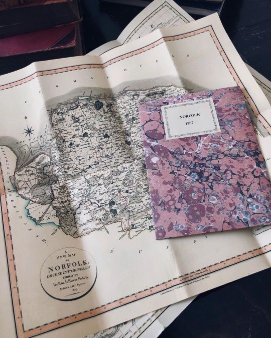
Happy Wednesday! ⠀⠀⠀⠀⠀⠀⠀⠀⠀ A gorgeous county map of of NORFOLK, 1807 by John Cary. Reprint Old Maps Library, 2022. ⠀⠀⠀⠀⠀⠀⠀⠀⠀ Norfolk is situated East Anglia in England, the county is a magnet for fans of the great outdoors, particularly bird watchers and boating enthusiasts. But there are so many other reasons to visit Norfolk . There are superb medieval churches, fascinating museums and stately homes, as well as lively seaside resorts and bags of entertainment for kids. ⠀⠀⠀⠀⠀⠀⠀⠀⠀ Did you know that people from Norfolk are sometimes known as Norfolk Dumplings, an allusion to the flour dumplings that were traditionally a significant part of the local diet. 🥟🏴 ⠀⠀⠀⠀⠀⠀⠀⠀⠀ ⏳Old Maps Library specialises in the reprint of Vintage Maps and Illustrations between the 17th to 19th centuries. ⠀⠀⠀⠀⠀⠀⠀⠀⠀ ⏳ We have a beautiful collection of Old Maps and Vintage Illustrations on our website. Link on our bio. . . . #oldmaps #vintagemaps #ilovehistory #countymaps #retromap (at London, Unιted Kingdom) https://www.instagram.com/p/CifdgJfo_-0/?igshid=NGJjMDIxMWI=
1 note
·
View note
Photo
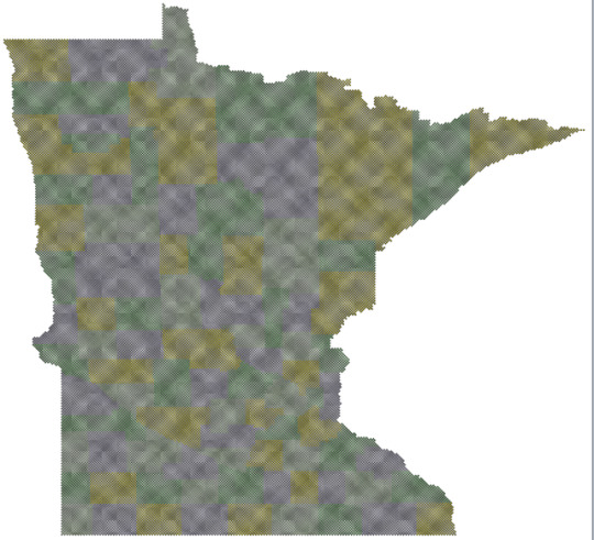
MN county map. Size is roughly 5x5 feet. The close-up view here centers on Aitkin County.
0 notes
Photo
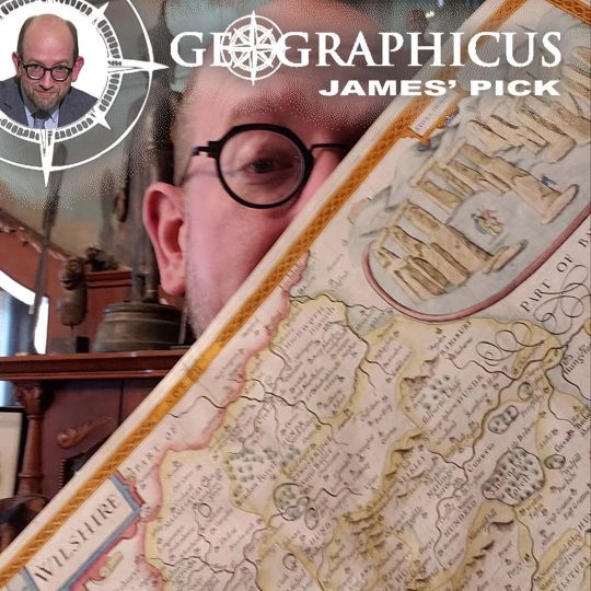
In ancient times Hundreds of years before the dawn of history Lived a strange race of people: THE DRUIDS No one knows who they were or what they were doing But their legacy remains HEWN into the living rock of #STONEHENGE #jamespick #johnspeed #wiltshire #salisbury #antiquemaps #countymaps #geographicusrareantiquemaps #li #possiblytheonlyspinaltapreferencepossibleinthemaptrade (at Geographicus Rare Antique Maps) https://www.instagram.com/p/B7qzlc6p8it/?igshid=tk4vqvotivd6
#stonehenge#jamespick#johnspeed#wiltshire#salisbury#antiquemaps#countymaps#geographicusrareantiquemaps#li#possiblytheonlyspinaltapreferencepossibleinthemaptrade
1 note
·
View note
Photo
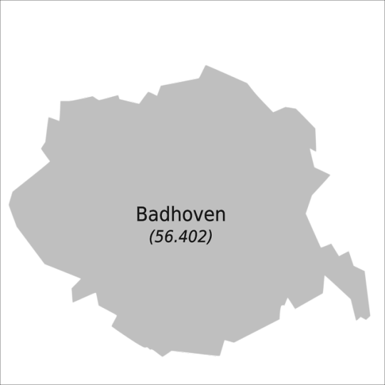

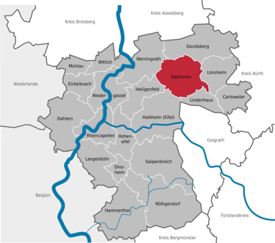
Die Stadt Badhoven, ihre Lage im Kreis Haldheim(Eifel) und ihre Stadtteile.
Sie grenzt an die Gemeinde Davidsberg, die Stadt Lönsheim, die Stadt Lindenhaus, die Kreisstadt Haldheim(Eifel), die Stadt Heiligenfeld sowie die Stadt Werningrath.
#lkhaldheim#geofiction#imaginary#map#fictionalcity#city#town#fictionaltown#fiction#imaginarytown#imaginarycity#county#countymap#imaginarycounty
0 notes
Link
0 notes
Link
0 notes
Link
0 notes
Link
0 notes
Link
0 notes
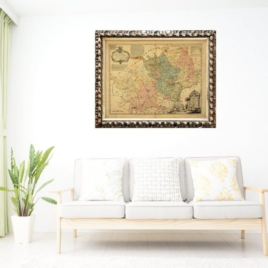
Photo
Happy Monday! ⠀⠀⠀⠀⠀⠀⠀⠀⠀ A gorgeous reprint map of Cambridgeshire, 1750 by Emanuel Bowen. He was a Welsh map engraver, who achieved the unique distinction of becoming Royal Mapmaker to both to King George II of Great Britain and Louis XV of France. He was highly regarded by his contemporaries for producing some of the largest, most detailed and most accurate maps of his era. ⠀⠀⠀⠀⠀⠀⠀⠀⠀ The map is divided into hundreds, drawn from surveys, assisted by the most approved modern maps, with a variety of improvements. Illustrated with historical extracts relative to the soil, air, natural produce, manufactures, trade, prevent the state of its principal towns. ⠀⠀⠀⠀⠀⠀⠀⠀⠀ ⭐︎ Cambridgeshire is a county in the East of England, bordering Lincolnshire to the north, Norfolk to the north-east, Suffolk to the east, Essex and Hertfordshire to the south, and Bedfordshire and Northamptonshire to the west. The city of Cambridge is the county town. ⠀⠀⠀⠀⠀⠀⠀⠀⠀ ⏳Old Maps Library specialises in the reprint of Vintage Maps and Illustrations between the 17th to 19th centuries. ⠀⠀⠀⠀⠀⠀⠀⠀⠀ ⏳ We have a beautiful collection of Old Maps and Vintage Illustrations on our website. → www.oldmapslibrary.com . . . #oldmaps #vintagemaps #countymap #antiquemaps #cambridgemap #maplover #oldmapslibrary #retromap #mapshop #ilovemaps #historicalmap #antiquemapsandprints #mapcollector (at London, Unιted Kingdom) https://www.instagram.com/p/CaPdmJvoGuw/?utm_medium=tumblr
#oldmaps#vintagemaps#countymap#antiquemaps#cambridgemap#maplover#oldmapslibrary#retromap#mapshop#ilovemaps#historicalmap#antiquemapsandprints#mapcollector
0 notes
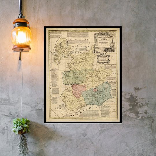
Photo
Happy Thursday! ⠀⠀⠀⠀⠀⠀⠀⠀⠀ Old maps have been part of human history for thousands of years. The oldest known world map, the Imago Mundi, was chiselled on a clay tablet in ancient Babylon in 6 B.C. ⠀⠀⠀⠀⠀⠀⠀⠀⠀ Ancient maps have the magic of taking us back in time and see the birth of the modern world. It takes us on a journey through the eyes of historians and cartographers, it is where they've imprinted their dreams and draw their ideas. ⠀⠀⠀⠀⠀⠀⠀⠀⠀ Here at Old Maps Library, we love how we can use an old map to explore the history of a new world, and what we can learn about the people who created them, and the romance of parts still unknown to us. ⠀⠀⠀⠀⠀⠀⠀⠀⠀ As Kevin J. Brown said: "Ancient maps are a touching reminder that our knowledge and our perception of the world are abundant and limited at the same time". ⠀⠀⠀⠀⠀⠀⠀⠀⠀ Are you also fascinated by old maps? ⠀⠀⠀⠀⠀⠀⠀⠀⠀ Old maps are a perfect gift filled with history and memories or an amazing keepsake from unique and breathtaking places around the world. ⠀⠀⠀⠀⠀⠀⠀⠀⠀ Old Maps Library reprint map of NOTTINGHAM SHIRE, describing its WAPONTAKES and DIVISIONS. Drawn from the last Authorities, assisted by the most approved Modern Maps, with various improvements. Illustrated with Historical Extracts relative to its Natural Produce, Air, Soil, Trade, Manufactures and present state of the principal Towns. By Emanuel Bowen, 1755. ⠀⠀⠀⠀⠀⠀⠀⠀⠀ ⏳ We have a beautiful collection of Old Maps and Vintage Illustrations on our website. Link in our bio. . . #oldmap #vintagemap #raremap #countymap #ukcountiesmap #cartographer #antiquemap #ancientmap #gallerywalldecor #mapas #instamap #mapdecor #mapsarecool #mapsofinstagram #mapsandillustrations #homedecorationideas #maplove #lovemaps #mapshop #mapsoftheworld #oldword #antiquemapsandprints #framedmaps #map #mapart #wallframe #mapprints #mappe #oldmapslibrary #mapasantiguos (at London, Unιted Kingdom) https://www.instagram.com/p/COiU2S3NeS4/?igshid=1parklg84ikj0
#oldmap#vintagemap#raremap#countymap#ukcountiesmap#cartographer#antiquemap#ancientmap#gallerywalldecor#mapas#instamap#mapdecor#mapsarecool#mapsofinstagram#mapsandillustrations#homedecorationideas#maplove#lovemaps#mapshop#mapsoftheworld#oldword#antiquemapsandprints#framedmaps#map#mapart#wallframe#mapprints#mappe#oldmapslibrary#mapasantiguos
1 note
·
View note
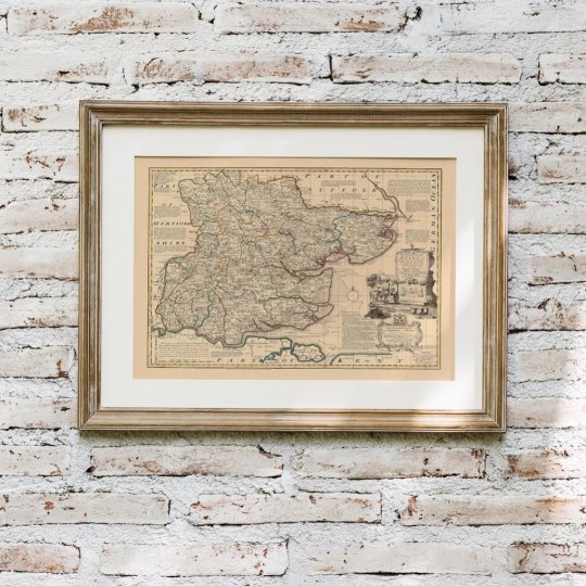
Photo
Happy Tuesday! ⠀⠀⠀⠀⠀⠀⠀⠀⠀ How about having a beautiful old map from where you live or your favourite place in your living room? It would make your home even more especial. ❤️ ⠀⠀⠀⠀⠀⠀⠀⠀⠀ Map of HARTFORDSHIRE - A reprint of a new Improved Map of the best surveys & intelligence, divided into its Hundreds; Shewing the Several roads, & true measured distances between Town & Town. Also the rectories & vicarages; the parks and seats of nobility and Gentry; with other useful particulars By Thomas Kitchin, Geographer, year 1755. ⠀⠀⠀⠀⠀⠀⠀⠀⠀ ⏳ Old Maps Library specialises in the reprint of Vintage Maps and Illustrations between the 17th to 19th centuries. Our prints are linen backed by hand, a technique that mapmakers used in the past to keep maps stronger for long journeys and weather changes. Nowadays, this technique is an important conservation method for restoring and preserving vintage maps and posters. ⠀⠀⠀⠀⠀⠀⠀⠀⠀ "Travel back to moments in time and discover the world heritage!" ⠀⠀⠀⠀⠀⠀⠀⠀⠀ ⏳ We have a beautiful collection of Old Maps and Vintage Illustrations on our website. Link in our bio. . . . . . #oldmaps #vintagemaps #countymap #antiquemaps #cartography #haritalar #ilovehistory #instamaps #maps #wallart #mapstagram #maplover #walldecorations #homeofficedecor #mapsandillustrations #oldmapsarecool #walldecorideas #ukcountiesmap #oldmapslibrary #retromap #mapshop #ilovemaps #historicalmap #mapsoftheworld #amazingmaps #antiquemapsandprints #framedmaps #wallframes #vintagemapsforsale #mapcollector (at London, Unιted Kingdom) https://www.instagram.com/p/COdKcOLFzpG/?igshid=1f1isnrylhu1v
#oldmaps#vintagemaps#countymap#antiquemaps#cartography#haritalar#ilovehistory#instamaps#maps#wallart#mapstagram#maplover#walldecorations#homeofficedecor#mapsandillustrations#oldmapsarecool#walldecorideas#ukcountiesmap#oldmapslibrary#retromap#mapshop#ilovemaps#historicalmap#mapsoftheworld#amazingmaps#antiquemapsandprints#framedmaps#wallframes#vintagemapsforsale#mapcollector
0 notes
Photo

Happy Wednesday!
⠀⠀⠀⠀⠀⠀⠀⠀⠀
Our second stop of the week is at Old Maps Library home county, MIDDLESEX. ❤
⠀⠀⠀⠀⠀⠀⠀⠀⠀
Our map is a fine reproduction of Middlesex records market towns and market days, towns where Quarter Sessions are held, towns where County Courts are held, Post Towns, and statistical information relating to London and Middlesex.
By Forster Groom & Co, 1883.
⠀⠀⠀⠀⠀⠀⠀⠀⠀
Middlesex was established in the Anglo-Saxon period from the territory of the Middle Saxons. The River Thames was the key to the history of Middlesex. From about 8000 BCE traders and settlers used the Thames as their waterway. During the Iron Age (c. 500 BCE) settlements existed at Brentford and Heathrow.
⠀⠀⠀⠀⠀⠀⠀⠀⠀
Nowadays, most of Middlesex, for administrative purposes, became part of Greater London in 1965. ⏳Old Maps Library specialises in the reprint of Vintage Maps and Illustrations between the 17th to 19th centuries.
⠀⠀⠀⠀⠀⠀⠀⠀⠀
⏳ We have a beautiful collection of Old Maps and Vintage Illustrations on our website. Link on our bio. .
.
.
.
#oldmaps #vintagemaps #middlesex #antiquemaps #middlesexmap #haritalar #ilovehistory #instamaps #maps #wallart #mapstagram #maplover #walldecorations #homeofficedecor #mapsandillustrations #oldmapsarecool #walldecorideas #countymap #oldmapslibrary #retromap #mapshop #ilovemaps #historicalmap #mapsoftheworld #amazingmaps #antiquemapsandprints #framedmaps #wallframes #vintagemapsforsale #mapcollector
https://www.instagram.com/p/CK1Zi1YJC7E/?igshid=ql77g90zaa41
#oldmaps#vintagemaps#middlesex#antiquemaps#middlesexmap#haritalar#ilovehistory#instamaps#maps#wallart#mapstagram#maplover#walldecorations#homeofficedecor#mapsandillustrations#oldmapsarecool#walldecorideas#countymap#oldmapslibrary#retromap#mapshop#ilovemaps#historicalmap#mapsoftheworld#amazingmaps#antiquemapsandprints#framedmaps#wallframes#vintagemapsforsale#mapcollector
0 notes
Photo

Happy Wednesday!
We are showing today another beautiful county map, this time we are visiting a county in southwest England.
⠀⠀⠀⠀⠀⠀⠀⠀⠀
It’s known for its Jurassic Coast, a long stretch on the English Channel where the cliffs contain many fossils, and rock formations show millions of years of geological history.
⠀⠀⠀⠀⠀⠀⠀⠀⠀
It has two prominent natural landmarks, Durdle Door, an ancient stone arch, and the layered cliffs at nearby Lulworth Cove.
⠀⠀⠀⠀⠀⠀⠀⠀⠀
The towns of Poole, Weymouth, and Swanage are very popular for their sandy beaches.
⠀⠀⠀⠀⠀⠀⠀⠀⠀
Do you know which county is it?
⠀⠀⠀⠀⠀⠀⠀⠀⠀
The beautiful county of Dorset shire.
⠀⠀⠀⠀⠀⠀⠀⠀⠀
Old Maps Library reprint map of DORSET SHIRE is divided into its hundreds, drawn from the best authorities, assisted by the most approved Maps & Charts with various improvements.
⠀⠀⠀⠀⠀⠀⠀⠀⠀
Illustrated with Historical Extracts relative to its Natural produce. Manufactures, Trade, present state of its principal Towns, Sea Ports. By Emanuel Bowen, c.1760
⠀⠀⠀⠀⠀⠀⠀⠀⠀
“Travel back to moments in time and discover the world heritage!"
⠀⠀⠀⠀⠀⠀⠀⠀⠀
⏳ We have a beautiful collection of Old Maps and Vintage Illustrations on our website. Link on our bio.
⠀⠀⠀⠀⠀⠀⠀⠀⠀
.
.
.
.
.
#oldmap #vintagemap #raremap #dorset #countymap #iloveengland #antiquemap #ancientmap #gallerywalldecor #mapas #instamap #mapdecor #mapsarecool #mapsofinstagram #mapsandillustrations #homedecorationideas #maplove #lovemaps #mapshop #mapsoftheworld #oldword #antiquemapsandprints #framedmaps #map #mapart #wallframe #mapprints #mappe #oldmapslibrary #mapasantiguos (at London, Unιted Kingdom)
https://www.instagram.com/p/CIBDGmcJYfw/?igshid=c2tc3bt3r3h6
#oldmap#vintagemap#raremap#dorset#countymap#iloveengland#antiquemap#ancientmap#gallerywalldecor#mapas#instamap#mapdecor#mapsarecool#mapsofinstagram#mapsandillustrations#homedecorationideas#maplove#lovemaps#mapshop#mapsoftheworld#oldword#antiquemapsandprints#framedmaps#map#mapart#wallframe#mapprints#mappe#oldmapslibrary#mapasantiguos
0 notes
Photo
Happy Monday!
After a rainy and cold weekend in London, ideal for lazy days and perfect for recharging, I feel full of energy and ready for another week of work! How about you?
⠀⠀⠀⠀⠀⠀⠀⠀⠀
This week we continue our travels around English counties and cities, and today our map is a great reprint of Emanuel Bowen map of ESSEX, c.1750.
⠀⠀⠀⠀⠀⠀⠀⠀⠀
Essex is a county in southeast England, between London and the North Sea, and remains a predominantly rural county. In fact, 70% still undeveloped.
It’s a fantastic location with stunning towns.
The town of Colchester has Roman ruins and the Norman-era Colchester Castle.
Southwest, 18th-century Hylands House in Chelmsford is set in vast parklands.
In the north, we find the medieval market town of Saffron Walden, home to Jacobean estate Audley End House and Gardens.
⠀⠀⠀⠀⠀⠀⠀⠀⠀
Don’t you love an Old Map? I do!
Ancient maps are a perfect gift filled with history and memories, and a framed old map of your favourite place will create a beautiful piece to keep the travel dreams and make your home special.
⠀⠀⠀⠀⠀⠀⠀⠀⠀
⏳Old Maps Library specialises in the reprint of Vintage Maps and Illustrations between the 17th to 19th centuries.
⠀⠀⠀⠀⠀⠀⠀⠀⠀
⏳ We have a beautiful collection of Old Maps and Vintage Illustrations on our website. Link on our bio.
.
.
.
.
#oldmap #vintagemap #raremap #essex #countymap #englishcounties #antiquemap #ancientmap #gallerywalldecor #mapas #instamap #mapdecor #mapsarecool #mapsofinstagram #mapsandillustrations #homedecorationideas #maplove #lovemaps #mapshop #mapsoftheworld #oldword #antiquemapsandprints #framedmaps #map #mapart #wallframe #mapprints #mappe #oldmapslibrary #mapasantiguos (at London United Kingdom - UK)
https://www.instagram.com/p/CHp9Xs1pmFW/?igshid=27aevoij64fu
#oldmap#vintagemap#raremap#essex#countymap#englishcounties#antiquemap#ancientmap#gallerywalldecor#mapas#instamap#mapdecor#mapsarecool#mapsofinstagram#mapsandillustrations#homedecorationideas#maplove#lovemaps#mapshop#mapsoftheworld#oldword#antiquemapsandprints#framedmaps#map#mapart#wallframe#mapprints#mappe#oldmapslibrary#mapasantiguos
0 notes
Photo
Happy Tuesday! ⠀⠀⠀⠀⠀⠀⠀⠀⠀ A colourful beautiful map reprint of the County of Lancaster, c.1775. Accurate and rich in details the map was made by Emmanuel Bowen, a Welsh map engraver, who achieved the unique distinction of becoming Royal Mapmaker to both to King George II of Great Britain and Louis XV of France. ⠀⠀⠀⠀⠀⠀⠀⠀⠀ Lancaster is a city and the county town of Lancashire, England, standing on the River Lune. The House of Lancaster was a branch of the English royal family. The Duchy of Lancaster still holds large estates on behalf of Elizabeth II, who is also Duke of Lancaster. ⠀⠀⠀⠀⠀⠀⠀⠀⠀ Are you also fascinated by old map? Perfect as a gift filled with history and memories or as a keepsake of a unique and breathtaking place. ⠀⠀⠀⠀⠀⠀⠀⠀⠀ ⏳ We have a beautiful collection of Old Maps and Vintage Illustrations on our website. Link on our bio. ⠀⠀⠀⠀⠀⠀⠀⠀⠀ #framedmaps #mapsandglobes #lancaster #countymaps #oldmapsandprint #oldmapslibrary #vintagemapsforsale #cartographic #oldworld #coolmaps #amazingmaps #oldprints #vintagehomedecor #moremaps #mapsandglobes #shopsmall #supportsallbusinesses #whoneedsamap (at London, Unιted Kingdom) https://www.instagram.com/p/CZuCmyZItnd/?utm_medium=tumblr
#framedmaps#mapsandglobes#lancaster#countymaps#oldmapsandprint#oldmapslibrary#vintagemapsforsale#cartographic#oldworld#coolmaps#amazingmaps#oldprints#vintagehomedecor#moremaps#shopsmall#supportsallbusinesses#whoneedsamap
0 notes
Last Seen Blogs

hiddenpastry
hiddenpastry

alunasky-blog
Alunasky

akarmatutu
A Karma Tutu

harunamika
Untitled

summercaligirl95-blog
Work hard Play Harder