#vintagemapsforsale
Text

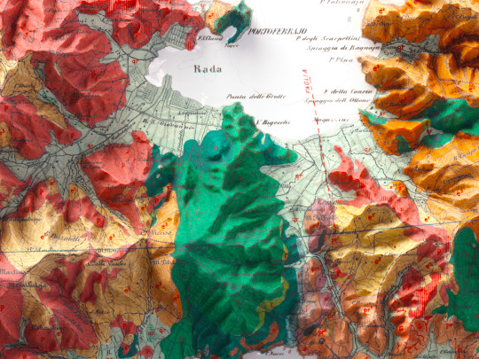
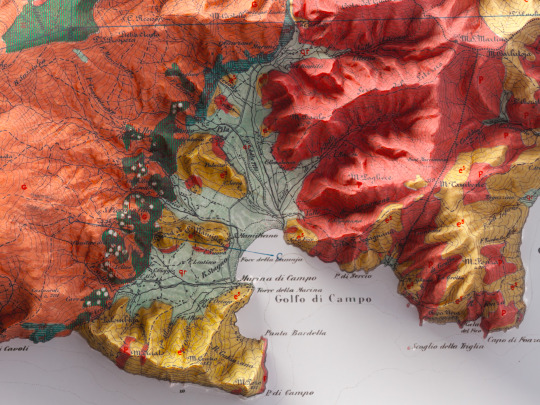
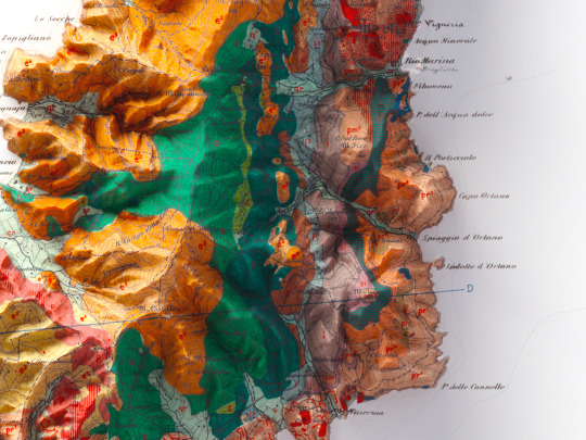
This was one of our first maps and we had to heavily restore it in order to make it.
Now it looks like a modern geological map, instead it is from 1880 and we think it deserves to be published!🙃
Original map info:
Carta geologica dell'Isola d'Elba, B. Lotti, P. Fossen, E. Mattirolo, G. Meneghini, 1885.
If you like our work, want to see our daily updates (or want to say hello to our studio), consider to follow our Instagram or Twitter account. Otherwise if are interested in our prints or have a custom request check our shop.
#maps#googlemaps#vintage#vintagemaps#vintagemapsforsale#elba#isoladelba#isoladelbamylove#tuscanygram#tuscanyitaly#tuscanyexperience#tuscanylovers#tuscanypeople#geological#geologicalsurvey#geologicalmapping#italygram#italytrip#italytravel#discoveritaly#discoveritalytravel#cartography#cartographyproject#cartographyart#shadedreliefmap#3dmapping#3dmaps
11 notes
·
View notes
Photo
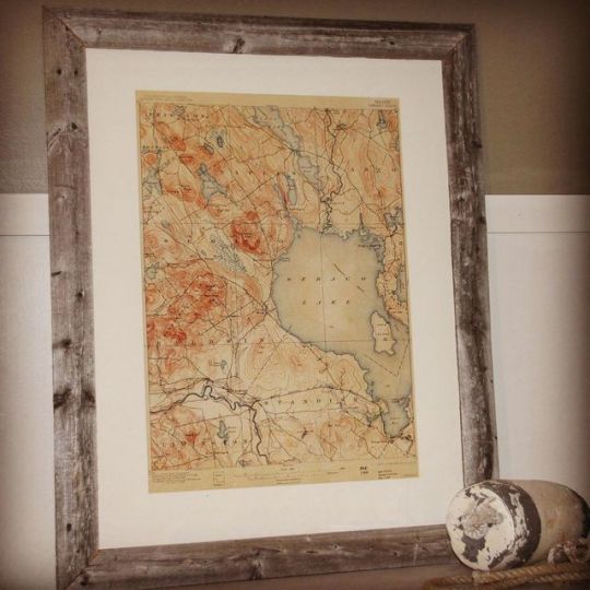
Ahh Sebago! Hang this one so you can remember every sweet summer memory you have made there. Available at www.coastandpines.com #coastandpinesdesign #mainelakes #sebagolake #nauticalchartsdecor #nauticalcharts #mainethewaylifeshouldbe⚓️ #vacationland #vintagecharts #vintagemapsforsale #madeinmaine https://www.instagram.com/p/B2vDGY6gJLS/?igshid=100mcosr10rmd
#coastandpinesdesign#mainelakes#sebagolake#nauticalchartsdecor#nauticalcharts#mainethewaylifeshouldbe⚓️#vacationland#vintagecharts#vintagemapsforsale#madeinmaine
0 notes
Text


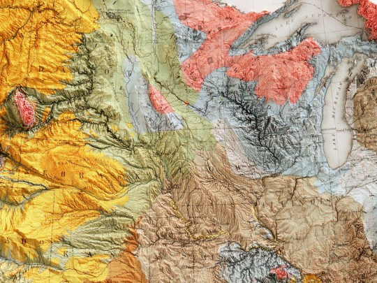

Geological map of United States, 1874.
Compiled by C.H. Hitchcock and W.P. Blake.
original map source: David Rumsey Collection
If you like our work, want to see our daily updates (or want to say hello to our studio), consider to follow our Instagram or Twitter account. Otherwise if are interested in our prints or have a custom request check our shop.
#hellovizart#shadedrelief#3dmaps#digitalart#cartografia#ilovegeology#geological#usa#unitedstates#vintagemaps#reliefmaps#artprint#retromaps#mapillustration#vintagemapsforsale#cartography#geology#gis#blenderart#3dmap
3 notes
·
View notes
Photo
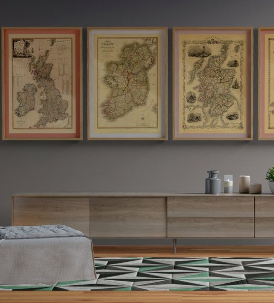

Happy Thursday! ⠀⠀⠀⠀⠀⠀⠀⠀⠀
Have your home decorate with gorgeous old maps of your favourite places. It will for sure elevates and make your home even more special. Just like this great room here! ⠀⠀⠀⠀⠀⠀⠀⠀⠀
Old Maps Library reprint maps of: 🇬🇧Great Britain & Ireland, 1794; 🇮🇪 Ireland, 1798; 🏴 Scotland, 1851. ⠀⠀⠀⠀⠀⠀⠀⠀⠀ ⠀⠀⠀⠀⠀⠀⠀⠀⠀
0 notes
Photo

Happy Tuesday!
Framing a vintage map of your favourite place or illustration creates a beautiful piece that makes your home special.
⋆ Map of Europe with parts of Asia & Africa. By John Disturnell, 1840
⋆ Vintage Illustration of Feathers by Adolphe Millot, published in Paris circa 1897-1904
⠀⠀⠀⠀⠀⠀⠀⠀⠀
#oldmapsandprint#giftideas#vintagemapsforsale#vintagehomedecoration#supportsmallbusiness#giftsforhim#giftsforher#shopsmall#supportlocalbusiness#oldmapslibrary
0 notes
Photo

Happy Wednesday! ⠀⠀⠀⠀⠀⠀⠀⠀⠀ We are travelling back today to ancient Persia, a historic region of southwestern Asia, where now is modern Iran. Persia is among one of the oldest inhabited regions in the world. The name was used for centuries and originated from a region of southern Iran formerly known as Persis, alternatively as Pārs or Parsa, modern Fārs. It gradually extended, and was used by the ancient Greeks and others to apply to the whole Iranian plateau. The people of that region have traditionally called their country Iran, “Land of the Aryans", and that name was officially adopted in 1935. ⠀⠀⠀⠀⠀⠀⠀⠀⠀ Old Maps Library has a gorgeous reprint map o Persia, 1851 by John Tallis. The map illustrates Persia – from Russia and the Caspian Sea in the north to the Persian Gulf in the south – from Turkey in the West to Cabool in the East. It has attractive vignette views surrounding the map, which illustrate the people & customs of that region, like Ispahan, Kurds, Persian on Horse & a Bactrian Camel. ⠀⠀⠀⠀⠀⠀⠀⠀⠀ ⏳Old Maps Library specialises in the reprint of Vintage Maps and Illustrations between the 17th to 19th centuries. ⠀⠀⠀⠀⠀⠀⠀⠀⠀ ⏳ We have a beautiful collection of Old Maps and Vintage Illustrations on our website. Link on our bio. . . . . #vintagemapsforsale #vintagehomedecoration #supportsmallbusiness #giftsforhim #giftsforher #persia #shopsmall #supportlocalbusiness #lovegolborne #visitportobello #oldmapslibrary (at London, Unιted Kingdom) https://www.instagram.com/p/Cds8QWVox6B/?igshid=NGJjMDIxMWI=
#vintagemapsforsale#vintagehomedecoration#supportsmallbusiness#giftsforhim#giftsforher#persia#shopsmall#supportlocalbusiness#lovegolborne#visitportobello#oldmapslibrary
1 note
·
View note
Photo

Happy Monday!
It’s an exciting and much waited week for everyone around UK, and of course for us here at Old Maps Library!
After 4 long months in lockdown, tomorrow we’ll be back with our stall in Portobello Market, our favourite & our best street market in London!
⠀⠀⠀⠀⠀⠀⠀⠀⠀
We cannot wait to see everyone! Come to visit us and take a tour back to moments in time with our beautiful collection of Old Maps & Vintage Illustrations.
⠀⠀⠀⠀⠀⠀⠀⠀⠀
See you tomorrow!
⠀⠀⠀⠀⠀⠀⠀⠀⠀
#mymarket #visitportobello #loveportobello #shopsmall #giftideas #vintagemapsforsale #vintagehomedecoration #vintagefleamarket #supportsmallbusiness #giftsforhim #giftsforher #supportlocalbusiness #lovegolborne #whoneedsamap #mapsandatlases #oldmapslibrary #mapart #decorativemap #oldprint #cartographic #oldworld #oldworlddecor #homedecorationideas #maplove #lovemaps #mapsarecool #londonstreetmarket (at Portobello and Golborne Road market)
https://www.instagram.com/p/CNkYLV-FoMP/?igshid=ik1e12tcfyay
#mymarket#visitportobello#loveportobello#shopsmall#giftideas#vintagemapsforsale#vintagehomedecoration#vintagefleamarket#supportsmallbusiness#giftsforhim#giftsforher#supportlocalbusiness#lovegolborne#whoneedsamap#mapsandatlases#oldmapslibrary#mapart#decorativemap#oldprint#cartographic#oldworld#oldworlddecor#homedecorationideas#maplove#lovemaps#mapsarecool#londonstreetmarket
2 notes
·
View notes
Photo

Happy Wednesday! ⠀⠀⠀⠀⠀⠀⠀⠀⠀ Now that we are starting travelling again, why not to plan your next destination and keep the travel dream alive with a gorgeous old map. ⠀⠀⠀⠀⠀⠀⠀⠀⠀ We have a great collection of Old Maps on our website. ▶︎ www.oldmapslibrary.com ⠀⠀⠀⠀⠀⠀⠀⠀⠀ A reprint map of a plan of the city of Rome, Indicating all of the Antiquities and New Decorations. The views are of both Roman ruins such as the Pantheon of Agrippa, Trajan’s Column, and the Colosseum (called here “Anfiteatro di Flavio”), and important city buildings such as St. Peter’s Basilica at the Vatican, the Campidoglio, and the Basilica of Santa Maria Maggiore. The central map shows streets, plazas, significant buildings, and landmarks, with a key in the lower-left indicating some major monuments. A compass is drawn in the lower right. Beside it is a list of 14 neighborhoods of Rome, along with the map’s publication information. By Venanzio Monaldini, 1829 . . . #haritalar #retromap #oldmapsandprint #giftideas #vintagemapsforsale #vintagehomedecoration #supportsmallbusiness #shopsmall #supportlocalbusiness #lovegolborne #oldmapslibrary (at London, Unιted Kingdom) https://www.instagram.com/p/Ca4zAJ0IYx9/?utm_medium=tumblr
#haritalar#retromap#oldmapsandprint#giftideas#vintagemapsforsale#vintagehomedecoration#supportsmallbusiness#shopsmall#supportlocalbusiness#lovegolborne#oldmapslibrary
0 notes
Photo
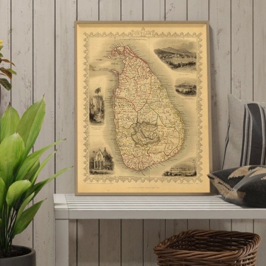
Happy Monday! ⠀⠀⠀⠀⠀⠀⠀⠀⠀ Let your imagination run wild with the help of one of our vintage style maps, like this gorgeous map of CEYLON (SRI LANKA), 1851 ⠀⠀⠀⠀⠀⠀⠀⠀⠀ Do you know where the name "Ceylon" comes from? From the Arab word “saheelan” came the many variations of Ceylon. Celiao in Portuguese, Selan in Spanish, Selon in French. The name was later formalized as Ceylon when the island became a British colony. Ceylon is the name that was used to name the famous tea and many other products exported from the island. Ceylon was the official name until a couple of decades after independence from Britain. ⠀⠀⠀⠀⠀⠀⠀⠀⠀ The current name of Sri Lanka was settled in 1972, when the island became a fully fledged republic. Lanka was taken from the ancient name of the island, and joined with Sri, meaning “resplendent”. So, Sri Lanka means Resplendent Island. ⠀⠀⠀⠀⠀⠀⠀⠀⠀ The name Sri Lanka is sometimes pronounced Shri Lanka, as this was a preference of a previous prime minister. He liked it that way, and tried to encourage this pronunciation. ⠀⠀⠀⠀⠀⠀⠀⠀⠀ ⏳ Old Maps Library reprint of a decorative and detailed mid-19th century map of Sri Lanka (formerly Ceylon). It was drawn and engraved by J. Rapkin. It has extraordinary detail, naming towns, lakes, and rivers. Illustrated are views of the ruins of a Dagoba at Thuparamaya, a Buddhist Temple, the Lake of Kandy, Adam’s Peak, and the City of Columbo. ⠀⠀⠀⠀⠀⠀⠀⠀⠀ #framedmaps #mapsandglobes #oldmapslibrary #vintagemapsforsale #mapsofantiquity #retromap #mapsandatlases #amazingmaps (at London, Unιted Kingdom) https://www.instagram.com/p/CazvQVooYp2/?utm_medium=tumblr
#framedmaps#mapsandglobes#oldmapslibrary#vintagemapsforsale#mapsofantiquity#retromap#mapsandatlases#amazingmaps
0 notes
Photo
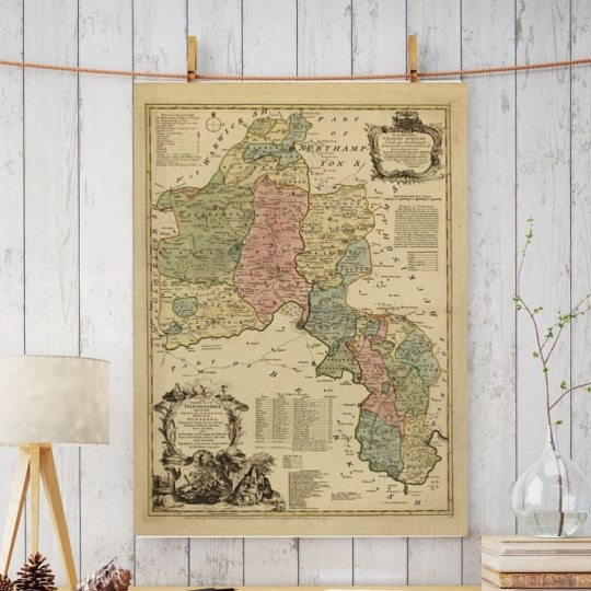
Happy Thursday! Hope you all had a good week so far. ⠀⠀⠀⠀⠀⠀⠀⠀⠀ I've chosen today another gorgeous map of this beautiful county of England, Oxfordshire. The county is home to important Roman sites and the famous University of Oxford. Situated in south-central England and located almost entirely within the Thames basin. ⠀⠀⠀⠀⠀⠀⠀⠀⠀ The map by Thomas Kitchin, was dedicated to the Duke of Marlborough, and has a cartouche with the scene of scholars debating alongside, and a list of the 20 Oxford Colleges. It was published by T & J Bowles and John Tinneys, London, c.1750 ⠀⠀⠀⠀⠀⠀⠀⠀⠀ Reprint by Old Maps Library 2022 ⠀⠀⠀⠀⠀⠀⠀⠀⠀ ⏳ Old Maps Library specialises in the reprint of Vintage Maps and Illustrations between the 17th to 19th centuries. ⠀⠀⠀⠀⠀⠀⠀⠀⠀ 🔎 Our prints are linen backed by hand, this technique gives it more durability and a beautiful vintage finish look. ⠀⠀⠀⠀⠀⠀⠀⠀⠀ ⏳Linen backing is a technique that mapmakers used in the past as a solution to keep the maps stronger for long journeys and weather changes. ⠀⠀⠀⠀⠀⠀⠀⠀⠀ 🔎Nowadays, this technique is an important conservation method for restoring and preserving vintage maps and posters. ⠀⠀⠀⠀⠀⠀⠀⠀⠀ ⏳Our maps are folded and fitted into a marbled slipcase. ⠀⠀⠀⠀⠀⠀⠀⠀⠀ Are you also fascinated by old maps? We have a beautiful collection of Old Maps and Vintage Illustrations on our website. Link on our bio. ⠀⠀⠀⠀⠀⠀⠀⠀⠀ ⏳ ⠀⠀⠀⠀⠀⠀⠀⠀⠀ "Travel back to moments in time and discover the world heritage!" ⠀⠀⠀⠀⠀⠀⠀⠀⠀ #oldmapsandprint #giftideas #vintagemapsforsale #vintagehomedecoration #vintagefleamarket #supportsmallbusiness #giftsforhim #giftsforher #shopsmall #supportlocalbusiness #lovegolborne #visitportobello #whoneedsamap #mapsandatlases #mapa #oldmapslibrary #mapart #homedecorationideas #maplove #lovemaps #mapsarecool (at London, Unιted Kingdom) https://www.instagram.com/p/CZzWEV2oSD5/?utm_medium=tumblr
#oldmapsandprint#giftideas#vintagemapsforsale#vintagehomedecoration#vintagefleamarket#supportsmallbusiness#giftsforhim#giftsforher#shopsmall#supportlocalbusiness#lovegolborne#visitportobello#whoneedsamap#mapsandatlases#mapa#oldmapslibrary#mapart#homedecorationideas#maplove#lovemaps#mapsarecool
0 notes
Photo
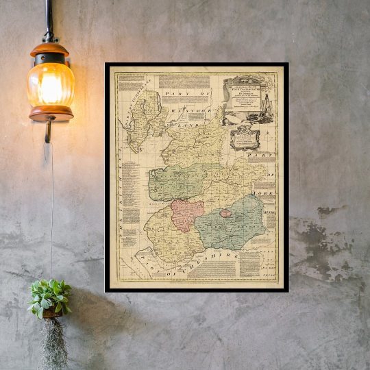
Happy Tuesday! ⠀⠀⠀⠀⠀⠀⠀⠀⠀ A colourful beautiful map reprint of the County of Lancaster, c.1775. Accurate and rich in details the map was made by Emmanuel Bowen, a Welsh map engraver, who achieved the unique distinction of becoming Royal Mapmaker to both to King George II of Great Britain and Louis XV of France. ⠀⠀⠀⠀⠀⠀⠀⠀⠀ Lancaster is a city and the county town of Lancashire, England, standing on the River Lune. The House of Lancaster was a branch of the English royal family. The Duchy of Lancaster still holds large estates on behalf of Elizabeth II, who is also Duke of Lancaster. ⠀⠀⠀⠀⠀⠀⠀⠀⠀ Are you also fascinated by old map? Perfect as a gift filled with history and memories or as a keepsake of a unique and breathtaking place. ⠀⠀⠀⠀⠀⠀⠀⠀⠀ ⏳ We have a beautiful collection of Old Maps and Vintage Illustrations on our website. Link on our bio. ⠀⠀⠀⠀⠀⠀⠀⠀⠀ #framedmaps #mapsandglobes #lancaster #countymaps #oldmapsandprint #oldmapslibrary #vintagemapsforsale #cartographic #oldworld #coolmaps #amazingmaps #oldprints #vintagehomedecor #moremaps #mapsandglobes #shopsmall #supportsallbusinesses #whoneedsamap (at London, Unιted Kingdom) https://www.instagram.com/p/CZuCmyZItnd/?utm_medium=tumblr
#framedmaps#mapsandglobes#lancaster#countymaps#oldmapsandprint#oldmapslibrary#vintagemapsforsale#cartographic#oldworld#coolmaps#amazingmaps#oldprints#vintagehomedecor#moremaps#shopsmall#supportsallbusinesses#whoneedsamap
0 notes
Photo
Hello, Whenever you are hope you are all well and had a great beginning of 2022! We are taking slowly over here. January is always a month for making new plans and to recharge batteries. Christmas time was crazy and amazing at the same time! It felt great to be back at the stalls, it was so nice to meet new people and reconnect with old customers. ⠀⠀⠀⠀⠀⠀⠀⠀⠀ From this week, we will be on Saturdays at Portobello Market. And, of course our online shop never closes. You are only a click away of our unique collection of Old Maps & Vintage Illustrations. ⠀⠀⠀⠀⠀⠀⠀⠀⠀ I will be sharing some of my favourites with you soon. Have a great week! ❤️ ⠀⠀⠀⠀⠀⠀⠀⠀⠀ #oldmapsandprint #oldmapslibrary #vintagemapsforsale #mapsandatlases #cartographic #shopsmall #supportsallbusinesses (at London, Unιted Kingdom) https://www.instagram.com/p/CY1X-9_ofHD/?utm_medium=tumblr
#oldmapsandprint#oldmapslibrary#vintagemapsforsale#mapsandatlases#cartographic#shopsmall#supportsallbusinesses
0 notes
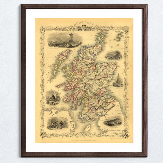
Photo

Happy Tuesday! Hope you all had a great start of the week. ⠀⠀⠀⠀⠀⠀⠀⠀⠀ Old Maps Library family are at the moment working like busy bees. Printing, cutting, glueing & folding our beautiful maps for X-mas Markets season! ⠀⠀⠀⠀⠀⠀⠀⠀⠀ We absolutely love this time of the year, and as we couldn't work over this period last year, you can imagine how excited we are! ⠀⠀⠀⠀⠀⠀⠀⠀⠀ Just for a sneak peak, more maps like this one here are on the making. - The Shires of Stirling and Clackmannan - A great map of a Scotland shire, from 1725 by the Geographer Herman Moll. ⠀⠀⠀⠀⠀⠀⠀⠀⠀ Our reprints are linen backed by hand, making our old maps looking even more special. Maps are folded and will come inside a beautiful hand wrapped marbled slipcase. ⠀⠀⠀⠀⠀⠀⠀⠀⠀ We have an amazing collection of Old Maps & Vintage Illustrations on our website. Link in bio 🔝 ⠀⠀⠀⠀⠀⠀⠀⠀⠀ #haritalar #retromap #oldmapsandprint #giftideas #vintagemapsforsale #vintagehomedecoration #vintagefleamarket #supportsmallbusiness #giftsforhim #giftsforher #scotlandshires #shopsmall #supportlocalbusiness #lovegolborne #visitportobello #whoneedsamap #mapsandatlases #mapa #oldmapslibrary #mapart #mapping #scotlandmap #oldprint #cartographic #oldworld #oldworlddecor #homedecorationideas #maplove #lovemaps #mapsarecool (at London, Unιted Kingdom) https://www.instagram.com/p/CVfqvyGN_1J/?utm_medium=tumblr
#haritalar#retromap#oldmapsandprint#giftideas#vintagemapsforsale#vintagehomedecoration#vintagefleamarket#supportsmallbusiness#giftsforhim#giftsforher#scotlandshires#shopsmall#supportlocalbusiness#lovegolborne#visitportobello#whoneedsamap#mapsandatlases#mapa#oldmapslibrary#mapart#mapping#scotlandmap#oldprint#cartographic#oldworld#oldworlddecor#homedecorationideas#maplove#lovemaps#mapsarecool
0 notes
Photo
Happy Sunday! Enjoy your day wherever you are! ⠀⠀⠀⠀⠀⠀⠀⠀⠀ The idea is not to live forever, but to create something that will. - Andy Warhol - ⠀⠀⠀⠀⠀⠀⠀⠀⠀ Maps have been around forever! Cartography, the art and science of making maps, has been part of human history for thousands of years. Old maps have the magic of taking us back in time and see the birth of the modern world. ⠀⠀⠀⠀⠀⠀⠀⠀⠀ The oldest know world map the Imago Mundi was chiselled on a clay tablet in ancient Babylon in 6 B.C. Ancient Greeks in 4 B.C had similar maps though they correctly believed that the earth was not flat, but a sphere. The First reasonably accurate world map was drawn by hand on paper by Gerardus Mercator, a Flemish geographer. ⠀⠀⠀⠀⠀⠀⠀⠀⠀ Anyone else loves old maps? ⠀⠀⠀⠀⠀⠀⠀⠀⠀ ⏳Old Maps Library specialises in the reprint of Vintage Maps and Illustrations between the 17th to 19th centuries. ⠀⠀⠀⠀⠀⠀⠀⠀⠀ ⏳We have a beautiful collection on our website. Link on our bio. ⠀⠀⠀⠀⠀⠀⠀⠀⠀ #framedmaps #mapsandglobes #countrymap #ancientmaps #oldmapsandprint #oldmapslibrary #vintagemapsforsale #mapsofantiquity #retromap #mapsandatlases #mapa #haritalar #mapart #mapping #decorativemap #oldprint #citymap #oldworld #coolmaps #amazingmaps #oldprints #vintagehomedecor #moremaps #mapsandglobes #shopsmall #supportsallbusinesses #whoneedsamap #vintagehomedecore #historygeek #irelandmap (at London, Unιted Kingdom) https://www.instagram.com/p/CVaEE-eop3W/?utm_medium=tumblr
#framedmaps#mapsandglobes#countrymap#ancientmaps#oldmapsandprint#oldmapslibrary#vintagemapsforsale#mapsofantiquity#retromap#mapsandatlases#mapa#haritalar#mapart#mapping#decorativemap#oldprint#citymap#oldworld#coolmaps#amazingmaps#oldprints#vintagehomedecor#moremaps#shopsmall#supportsallbusinesses#whoneedsamap#vintagehomedecore#historygeek#irelandmap
1 note
·
View note
Photo
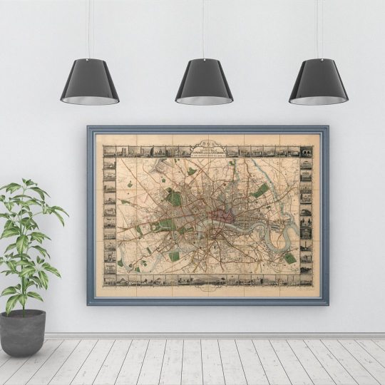
Happy Thursday! "I like the spirit of this great London which I feel around me." - Charlotte Bronze - ⠀⠀⠀⠀⠀⠀⠀⠀⠀ Another absolutely stunning map of London. TALLIS’S ILLUSTRATED PLAN OF LONDON AND ITS ENVIRONS, 1851. ⠀⠀⠀⠀⠀⠀⠀⠀⠀ A victorian Map of the City of London, published by John Tallis & Co. London & New York. Map borders with 48 city views, extending to Hammersmith in the west, clockwise to Cricklewood, Hampstead, Stamford Hill, Leytonstone, Greenwich, Peckham, Battersea Rise and Parson’s Green. Reprint Old Maps Library, 2021. ⠀⠀⠀⠀⠀⠀⠀⠀⠀ ⏳ We have this map, and many others Old Maps and Vintage Illustrations on our online shop. Link on our bio. ⠀⠀⠀⠀⠀⠀⠀⠀⠀ If you are in London, you can find us at Portobello Market, Notting Hill. ⠀⠀⠀⠀⠀⠀⠀⠀⠀ #londonmap #mapoflondon #oldmapsandprint #giftideas #vintagemapsforsale #vintagehomedecoration #vintagefleamarket #supportsmallbusiness #giftsforhim #giftsforher #eastindia #shopsmall #supportlocalbusiness #lovegolborne #visitportobello #whoneedsamap #mapsandatlases #mapa #oldmapslibrary #mapart #mapping #decorativemap #oldprint #cartographic #oldworld #oldworlddecor #homedecorationideas #maplove #lovemaps #mapsarecool (at London, Unιted Kingdom) https://www.instagram.com/p/CT4xTtrI1LL/?utm_medium=tumblr
#londonmap#mapoflondon#oldmapsandprint#giftideas#vintagemapsforsale#vintagehomedecoration#vintagefleamarket#supportsmallbusiness#giftsforhim#giftsforher#eastindia#shopsmall#supportlocalbusiness#lovegolborne#visitportobello#whoneedsamap#mapsandatlases#mapa#oldmapslibrary#mapart#mapping#decorativemap#oldprint#cartographic#oldworld#oldworlddecor#homedecorationideas#maplove#lovemaps#mapsarecool
0 notes
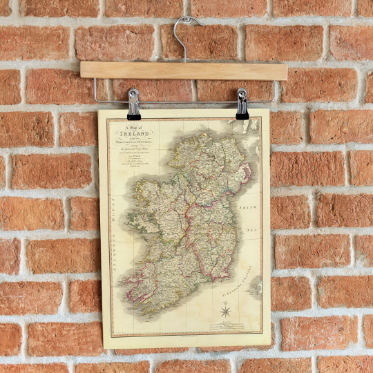
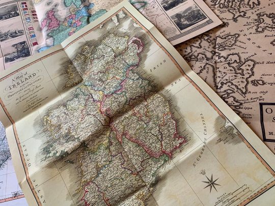
Photo

Happy Tuesday! “There’s something about arriving in new cities, wandering empty streets with no destination. I will never lose the love for the arriving, but I’m born to leave.” - Charlotte Eriksson - ⠀⠀⠀⠀⠀⠀⠀⠀⠀ I miss travelling so much! How about you? I love meeting new people, exploring new cultures. I'm even missing packing! I don't know when will be my next adventure, and where. Until then I'm more like an armchair traveller, comfortable at home with an old map in hand planning my next stop. What would be your dream destination? ⠀⠀⠀⠀⠀⠀⠀⠀⠀ Old Maps Library has a great collection of Vintage Maps to keep those dreams alive. Just like this beautiful map of IRELAND, 1797 by D A Beaufort. ⠀⠀⠀⠀⠀⠀⠀⠀⠀ ⏳ Old Maps Library specialises in the reprint of Vintage Maps and Illustrations between the 17th to 19th centuries. ⠀⠀⠀⠀⠀⠀⠀⠀⠀ 🔎 Our prints are linen backed by hand, this technique gives it more durability and a beautiful vintage finish look. ⠀⠀⠀⠀⠀⠀⠀⠀⠀ ⏳Linen backing is a technique that mapmakers used in the past as a solution to keep the maps stronger for long journeys and weather changes. ⠀⠀⠀⠀⠀⠀⠀⠀⠀ ⏳Our maps are folded and fitted into a marbled slipcase. ⠀⠀⠀⠀⠀⠀⠀⠀⠀ Are you also fascinated by old maps? ⠀⠀⠀⠀⠀⠀⠀⠀⠀ "Travel back to moments in time and discover the world heritage!" ⠀⠀⠀⠀⠀⠀⠀⠀⠀ We have this and more on our website! →Link in Bio ⠀⠀⠀⠀⠀⠀⠀⠀⠀ #framedmaps #mapsandglobes #irelandmap #ancientmaps #oldmapsandprint #oldmapslibrary #vintagemapsforsale #mapsofantiquity #retromap #mapsandatlases #mapa #haritalar #mapart #mapping #decorativemap #oldprint #cartographic #oldworld #coolmaps #amazingmaps #oldprints #vintagehomedecor #moremaps #mapsandglobes #shopsmall #supportsallbusinesses #whoneedsamap #vintagehomedecore #historygeek #mapofireland (at London, Unιted Kingdom) https://www.instagram.com/p/CRjZTMjNt9r/?utm_medium=tumblr
#framedmaps#mapsandglobes#irelandmap#ancientmaps#oldmapsandprint#oldmapslibrary#vintagemapsforsale#mapsofantiquity#retromap#mapsandatlases#mapa#haritalar#mapart#mapping#decorativemap#oldprint#cartographic#oldworld#coolmaps#amazingmaps#oldprints#vintagehomedecor#moremaps#shopsmall#supportsallbusinesses#whoneedsamap#vintagehomedecore#historygeek#mapofireland
0 notes