#galboly
Photo

Hidden village of Galboly
2K notes
·
View notes
Text
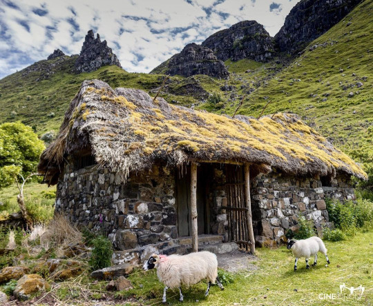
📍 Galboly, Co Antrim
Untitled

View On WordPress
33 notes
·
View notes
Text
Galboly, Contea di Antrim

instagram.com/cinedroneni/
0 notes
Text
Galboly, a lost village, Antrim Coast road
Love Ireland
1 note
·
View note
Text
Galboly: The Glens of Antrim's hidden village
Galboly: The Glens of Antrim’s hidden village
However, before the establishment of the farming village – or clachan – that would become Upper Galboly, the area seems to have been home to robbers or outlaws who preyed on what would become the coast road, but at the time was more like a dirt track.
Source link
View On WordPress
0 notes
Photo
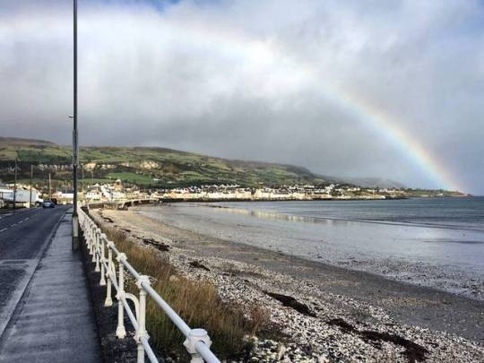
Looks like gold around Garron tower today. #survey #architects #extension #roadtrip #rainbow #gold #garrontower #barn #carnlough #glens #glensofantrim #galboly #causewaycoast #costalroute #sea #beach #irishweather (at Carnlough)
#costalroute#glens#survey#galboly#glensofantrim#causewaycoast#roadtrip#beach#architects#barn#gold#garrontower#rainbow#sea#extension#carnlough#irishweather
1 note
·
View note
Video
youtube
Why not visit 'The Clachan of Galboly' on your way to your land:
https://emerald-heritage.com
The Clachan (small settlement) was an isolated place on the mountain near Garron Tower. The Clachan had about 10 houses. There is now one house and a few ruins.
The People of Galboly in 1901
The O’Boyles lived in the first house. Charles was the head of the family and Lizzie was his wife. They had two children and also Arthur Robinson lived in the house, his relationship was unknown.
In house no. 2 Annie White and her son Robert Gibson lived.
The Blacks lived in house no. 3, Daniel and his sister Margaret.
One of the Murphy families lived in the fourth house. Patrick and Anne, his wife, had two children.
In house number 6 lived another Murphy family, Neal and Jane had four children.
The seventh house was unoccupied.
Lots of the people of Galboly were farmers and a few were housekeepers or scholars.
This information is from the 1901 census.
Living in Galboly was very hard work. Their diet included seafood. They had to get water from the coast road and then back up the mountain to Galboly. Every household kept pigs for food and to pay rent with. Lots of the people worked in Garron Tower when it was a hotel. Ladies often carried turf on their backs from the mountain to the Clachan before going to work in the hotel.
A big part of their diet was sea-food, rabbits and hares. There wasn’t much fire wood because most of our trees were gone, but they had turf banks which provided heating fuels. The donkey with creels was a necessary means of transport because they had to get the turf from the mountain banks and carry it down the narrow ‘perths’.
We think our deforestation crisis is pretty evident in this video
0 notes
Text
Ten kilometres northwest of Ballycastle in Co. Antrim is White Park Bay. Successive layers of rock yield Mesozoic fossils including ammonites, belemnites and Gryphaea. However, the cliffs and platforms are protected, but many loose blocks containing fossils and some washed out fossils can be found. The beach is also known as one of the few places in the world to have “singing sand” – when conditions are right, the extremely fine sand vibrates to make a humming noise. The location is also known as a historic manufacturing hub for flint axes and arrow heads, due to the abundance of flint nodules found in the cliffs, with artefacts dating back as far as 8,000 BC. The landscape also features passage tombs looking out over the sea, where, on a clear day, the coast of Scotland can be seen.
DIRECTIONS
♦ White Park Bay is 10km west of Ballycastle and 2km east of Dunseverick on Whitepark Road, which is part of the A2 Causeway Coastal Route. The bay is signposted from the road.
♦ Access to the beach is by steps and a footpath from the car park located just off Whitepark Road. Be sure to use the public car park and do not trespass on the Youth Hostel grounds.
♦ From the viewpoint by the car park, there are a number of steep stone steps down to a winding pathway, which takes you past the remains of the old “hedge school” and down to the beach.
♦ NT 27940 8847955
PROFILE INFO
FIND FREQUENCY: ♦♦♦ – When emerging from the footpath onto the beach, you will see Cretaceous chalk cliffs and wave cut platforms, with rocks and boulders on the beach to your left. However, it is more productive to turn right and head east towards Oweynamuck to find exposures of the Lower Jurassic Liassic Waterloo Mudstone Formation. Although much of the Lias is overlain by landslips of Cretaceous material and wind-blown sand, it can be found in scouring conditions in the toes of landslips and at low tide, particularly in a waterfall section west of the school and at Oweynamuck. Half way along the beach, at the foot of the chalk boulder field, exposures can be found at low tide in the right conditions.
CHILDREN: ♦♦♦ – The sandy beach is safe and easy to walk on, and access is not especially steep or difficult. However, the path is uneven and does involve some steep steps along its approximately 1.5km-long stretch. Searching for fossils in the chalk pebbles and rocks is straightforward, but the chalk is much harder to break than that which is typical in Southeast England. The boulder fields may prove tricky for younger children and the Lias exposures can be slippery, so care should be taken.
ACCESS: ♦♦♦♦ – From the car park, it is about a 1.5km walk to the beach. The path is not especially steep or difficult, although it does involve steep steps at the beginning and is uneven along its approximately 1.5km-long stretch. The sandy beach is easy to walk on but the boulder fields can be more of a challenge. However, they can be largely avoided, but the Lias and wave-cut platforms can be slippery.
TYPE: – Fossils are found in the foreshore exposures of Lower Jurassic Liassic mudstone and in pebbles, rocks and boulders from the overlying successions of Upper Cretaceous chalk.
FOSSIL HUNTING
Ammonites (including Crucilobiceras, Enderoceras, Gemmellaroceras, Hemimicroceras, Leptechioceras and Paltechioceras), bivalves (including Gryphaea sp.), brachiopods and gastropods are found in the mudstones. Belemnites, in particular, and echinoids and bivalves (including Inoceramus sp.) are common in the Upper Cretaceous chalks.
Belemnites and other fossils from the chalk can be seen in blocks and pebbles, and, if found in loose blocks, will require hammering or prepping out. Fossils from the Lias can be found when it is exposed. Ammonites are often pyritised and fragile but bivalves can be extracted quite easily. Collecting should be limited to loose fossils and fossils in loose blocks, as the bedrock and cliffs are protected as a SSSI and cannot be hammered.
Look out for shells, and loose bones, teeth and bone fragments in the areas of shingle. Occasionally, you can come across large lumps of the bone bed, although lumps of the bone bed are usually quite small because collectors have already split them down. You only need a small amount of the bed to get some finds. Common fossils are shark and fish teeth, and fish scales and coprolites. Fragments of bone are also very common and often are from ichthyosaurs and plesiosaurs, but identifiable bones are less common. You can also find fossil clams and oysters. However, it is a very popular location for collecting fossils, so competition means that the bone bed blocks are becoming harder to find. However, in recent times, the south side of the bridge is regularly washing out, with fresh cliff falls, giving rise to a good amount of material to search through.
The Red Marls are unfossilferous, so there is no point in searching within this layer. The bone bed comes from the top of the cliff at the base of the Lower Lias and is unreachable. Therefore, finding fossils at this location is dependent on cliff falls.
GEOLOGY
The rock forming the coast around White Park Bay consist of the lower Jurassic Waterloo Mudstone Formation. Resting with a major unconformity on the Lias is a thin unit of the Hibernian Greensands Formation overlain by the Cretaceous succession of the Rathlin Basin chalk deposits, including the Galboly Chalk, Cloghastucan Chalk (including the Oweynamuck Flint Bank) and the Creggan Chalk members. The chalk spans the Cenomanian to Santonian stages. The Jurassic rocks are about. 200 million years old and the chalks are about 100 to 80 million years old.

SAFETY
Common sense when collecting at all locations should always be used and knowledge of tide times taken into account. The sea does reach the cliffs at high tide, so collecting should be done on a falling tide. Care must be taken getting down from the embankment, as the steps may be slippery and dangerous in wet weather. There are occasional cliff paths but they are unmarked, unmade and sometimes unsafe. Therefore, we recommend they are avoided.
EQUIPMENT
The site is an ASSI, so hammering the bedrock is not permitted and only loose fossils may be collected. You may wish to take a chisel hammer to split larger, loose rocks but you may not hammer the bedrock as it is protected.
ACCESS RIGHTS
This site is an area of scientific interest (ASSI). This means you can visit the site, but hammering the bedrock is not permitted. For full information about the reasons for the status of the site and restrictions, download the PDF from The Department of Agriculture, Environment and Rural Affairs
It is important to follow our ‘Code of Conduct’ when collecting fossils or visiting any site. Please also read our ‘Terms and Conditions‘
LINKS
♦ Buy Fossils, Crystals, Tools
♦ Location Discussions
♦ Deposits Magazine
♦ Join Fossil Hunts
♦ UK Fossils Network
Sam Caethoven. Last inspected 2018, Updated 2018, Edited by Jon Trevelyan 2018
White Park Bay Ten kilometres northwest of Ballycastle in Co. Antrim is White Park Bay. Successive layers of rock yield Mesozoic fossils including ammonites, belemnites and…
#Ammonites#Ballycastle#Belemnites#coprolites#Cretaceous#Fossil Collecting#Fossils#Geology#Gryphaea#ichthyosaurs#Ireland#Jurassic#Northern Ireland#plesiosaurs#Waterloo Mudstone Formation#White Park Bay
0 notes
Video
youtube
Paysage - Village caché de Galboly jusqu'à la Cascade de Cranny - Comté d'Antrim - Irlande du Nord
Différents panoramas observés sur la route entre le village caché de Galboly (voir vidéo https://youtu.be/OcsxpeBxbik) et la cascade de Cranny (voir vidéo https://youtu.be/sT9xAXcgTbA).
0 notes
Video
youtube
Village caché de Galboly - Carnlough - Comté d'Antrim - Irlande du Nord
Coordonnées GPS: 55°03'26.8"N 5°58'52.5"W
Ce village est situé dans la vallée de Glencloy. Il n'est pas visible de la route puisqu'il est entouré d'arbres.
Au milieu du XIXe siècle, on y comptait une soixantaine d'habitants. Ceux-ci étaient principalement des agriculteurs. Cent ans plus tard, on n'y comptait que six habitants.
Les habitants auraient déserté le village suite à la modification des pratiques agricoles et de la mécanisation.
De plus, l'approvisionnement en eau potable était un réel problème puisque les habitants devaient s'approvisionner à partir d'une source située près de la route côtière.
Nous avons laissé notre véhicule sur le stationnement qui se trouve en bordure de la route Garron (A2) et nous avons poursuivi à pied dans la vallée pour nous rendre jusqu'à ce village.
La randonnée débute en face du stationnement. Il suffit de suivre le chemin tracé dans la vallée. Il y a une barrière que l'on doit ouvrir et refermer aussitôt derrière nous afin d'éviter que les moutons ne s'échappent.
Nous avons d'abord monté une pente plutôt abrupte. Au sommet de cette pente, il y a une autre barrière. Lors de notre passage, elle était ouverte. Nous sommes entrés dans cette section de la vallée et avons longé le muret en pierre.
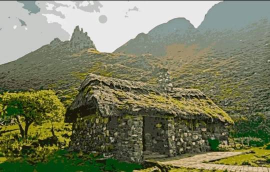
Après quelques minutes de marche, nous avons aperçu enfin le premier bâtiment (Lower Galboly) qui consistait en une ferme. En nous approchant de ce bâtiment, les autres bâtiments du village se sont dévoilés un à un.
Les bâtiments n'ont pas leurs toits d'origine. A l'époque, ceux-ci possédaient plutôt des toits de chaume.
Malgré que ce village soit en ruine, il possède un charme fou. Il suffit de voir au-delà des apparences et nous imaginer comment était la vie ici même il y a près de deux siècles.
Pour ceux qui le désirent, la randonnée peut se poursuivre jusqu'au sommet de la montagne. J'en ai parcouru un petit bout, suffisamment cependant pour avoir une vue d'ensemble du village.
Plus on avance vers le sommet, plus le panorama est sensationnel, ayant ainsi l'opportunité d'avoir une magnifique vue d'ensemble de toute la région.
0 notes
Video
youtube
Paysage - Cascades de Glenariff jusqu'au village caché de Galboly - Comté d'Antrim - Irlande du Nord Différents panoramas observés sur la route entre les cascades de Glenariff et le village caché de Galboly.
0 notes
Last Seen Blogs

gwynrielendgame
Gwynriel

kristyavson
⭐Kristy Avson's FanArt⭐

juggalomary
Mary

kobelt-draws
Kobelt Draws

cybeout
CybeOut