earthstory
The Earth Story
This is the blog homepage of the Facebook group "The Earth Story" (Click here to visit our Facebook group). “The Earth Story” are group of volunteers with backgrounds throughout the Earth Sciences. We cover all Earth sciences - oceanography, climatology, geology, geophysics and much, much more. Our articles combine the latest research, stunning photography, and basic knowledge of geosciences, and are written for everyone! Winner of the award for Best Education Weblog in the 2015 bloggies
We hope you find us to be a unique home for learning about the Earth sciences, and we hope you enjoy!
35341 posts
Don't wanna be here? Send us removal request.
Last Seen Blogs

luon77
Everything’s OK!


mercurymusing
Mercurial Musings

londonlocalguide
倫敦導遊哈太太

blujaishah
Blujai Shah
Photo

Manly Beacon Trail
Death Valley National Park
#trail#hike#desert#death valley#national park#geology#travel#black & white#B&W#Original photography#Original photographers#lensblr#photographers on tumblr#the earth story
147 notes
·
View notes
Photo
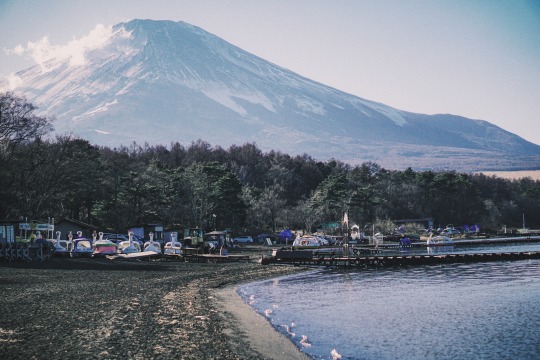
Mt. Fuji | 2017 (x)
#fuji#japan#volcano#mountain#volcanomonday#photography#Original Photography#Original photographers#lensblr#photographers on tumblr#The Earth story
173 notes
·
View notes
Video
sannioksanen
Heaven on Earth🏹🤍
2K notes
·
View notes
Text

I bought a 365 nm UV light to unlock forbidden colors in my minerals. Top is my manganoan calcite I got last week at a rock show (most fluorescent specimen I have in my collection, it turns a pink-orange which is pretty cool) and on the bottom is my cassiterite (not fluorescent) but I found that uv light will shine on dust so it was kinda interesting.
The photo I have does not do the fluorescent property ANY justice, it is very bright IRL. Maybe I'll see if I can take a better photo in the future.
#geology#rock talks#minerals#science#ultraviolet#fluorescent#mineralogy#mineralmonday#the earth story
200 notes
·
View notes
Photo
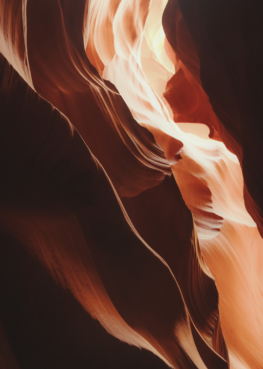
#photographers on tumblr#nature#antelope canyon#arizona#canyon#slot canyon#desert#geology#sandstone#navajo#lensblr#the earth story
1K notes
·
View notes
Video
brunopisani.photos Some spectacular light hitting the sharp pinnacles of Croda Da Lago, Dolomites. Antelao in the Background.
500 notes
·
View notes
Video
vimeo
The uncertain future of skiing in Scotland has inspired Jamie Kunka to make sustainable skis out of wood. Based in his cabin in the Scottish Highlands, Jamie is the last ski maker in Scotland.
Jamie began teaching himself how to make his wooden skis after watching a Vimeo Staff Pick about a wooden-surfboard maker in Vancouver Island, Canada. vimeo.com/27702618. Ten years on, The Last Ski Maker in Scotland is part homage to this original film and part a celebration of the power of film to inspire us all.
Jamie is still the only ski-maker in Scotland. Find him at lonelymountain.ski
Director / DP / Editor - Euan Wilding
Canon C100 Mkii
Sigma 18-35mm
Promist 1/4
Mavic 2 Pro
Senheisser MKh50
Graded with Filmconvert Nitrate
Music: Jūra by Ardie Son / Tokyo Street by Airtone
46 notes
·
View notes
Video
expllored
Drone tour in Kazakhstan
#Kazakhstan#drone#djimavicpro#Snow#forest#mountains#rock#rocks#geology#nature#travel#landscape#video#instagram#the earth story
590 notes
·
View notes
Video
seanparkerphotography
Skies were pretty dramatic this evening in Tucson! Swipe left to watch the timelapse I set up while I was shooting with my backup camera!
#timelapse#weather#clouds#nature#arizona#desert#cactus#cactii#saguaro#barrel cactus#landscape#travel#video#the earth story
418 notes
·
View notes
Video
hookedonsharkteeth
This is the tip of a tusk belonging to an extinct Mastodon.
Mastodons were browsers this means that they had a diet containing twigs, leaves, and smaller plant vegetation. They lived in warm lower land environments and Ice Age forests.
302 notes
·
View notes
Text
New Locations
One of the most useful things I’ve learned as a rock hound is how to locate new mineral sources. There are plenty of books and internet sources that can show you the major dig sites. This is good for beginners, but these sites can be crowded, mostly depleted, and often times left in a mess of tailings that you have to dig through to reach new material.
To start this off, definitely use local resources. Local rockhounding clubs and mineral societies often have plenty of useful info to get you started and occasionally have their own sites. Although I stick to my self and do my best to find my own locations, I will still occasionally use local groups’ sites and buy maps or guides to support them.
Maps are key. There are a variety of maps that’ll be a major help for finding mineral sources. I have four go to maps that I use regularly. I will go through three of the maps and explain how I use them, and then how I add it all up. Google maps (or Earth) is going to be a big help in getting an idea of the terrain and location.
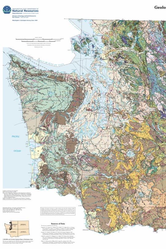
First is geological maps. Obviously each state is going to vary, but this is the USGS map showing Washington’s surface geology. Other good sources of geological maps are geology schools or schools that have geology departments. I would regularly check Montana Tech’s maps while in western Montana.
There are two ways I utilize these maps. 1: learn a little bit of geology to figure out what host rock different minerals form in. This is a little bit trickier than the second method but if your a curious person and like learning new things it’s not too bad.
2 (match the color): pull up a geological map and a regular map like google. Find some well know prospecting locations and try to locate them on the geological map. After locating, you can observe what the host in that site is and look for other areas with the same host rock. For example: A well know site near me for geodes and agate has a surface geology consisting of tertiary volcanic rock (Tv, brown). I can take that and simply look around for other brown areas on the map. I’ve used this method a few times and can even match it with other known dig sites. I also like to use google maps to see if there is exposed rock or Boulder fields in the area for easy access.

The Diggings have a very useful website that I utilize regularly. The black diamonds show documented mines, prospects, and placers. The blue boxes are current and expired mineral claims. I like to use this map to find where clusters of mineral claims are to find what can be in the general area. It’s also useful to make sure you aren’t on someone’s active claim. It’s always safe to check with the Bureau of Land Management, just to be sure.
Finally is OnX maps. I currently do not have their product downloaded so I can’t show a photo. This one isn’t involved with rockhounding but the hunting version is incredibly useful. OnX maps shows accurate land boundaries along with ownership. It does not show mineral claims but it is helpful in knowing where you are and making sure you are on lands where you can legally prospect. It also has multiple layers that you can customize, route tracking, and saving maps to use when offline. I believe the hunting version is $30 for a year of one state or $100 for the entire US, but don’t quote me on that. Also, I do not have a partnership with this brand. I am simply a very satisfied customer.
So that about sums up how I locate new deposits. There are plenty of other methods and resources you can use out there. Hoping this provides some help to anyone interested. I apologize for the long post.
384 notes
·
View notes
Text
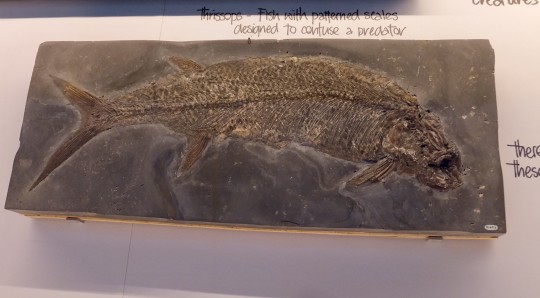
Thrissops
This fish is a Thrissops, a genus of ray-finned, bony fish that swam in the seas during the Jurassic and the Cretaceous. This extremely well preserved sample was preserved in the Kimmeridge clay, a geologic unit made of fine-grained sediment that sank to the bottom of a Jurassic seaway. The unit is exposed on the Dorset coast of England and travels offshore where it is the major source of North Sea oil and natural gas. This sample is housed in the Etches Collection – a private museum in the area where this fossil was found.
-JBB
Image credit: Lebatihem
https://flic.kr/p/2n2VpGj
#Science#fossil#fossils#fossilfriday#geology#paleontology#the earth story#thrissops#fish#jurassic#cretaceous#Dorset#Kimmeridge clay
129 notes
·
View notes
Text

A little fish 🐠
270 notes
·
View notes
Text
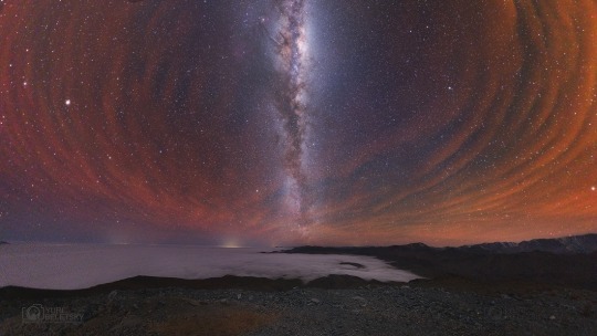
Airglow over the Atacama
One of the several rising steps that climbs to the main cordillera of the Andes through the driest desert on Earth resembles a beach abutting onto a sea of clouds below and provides the backdrop for this gorgeous photo of airglow above the southern skies with our galaxy in the sky above. The ripples are caused by atmospheric waves and produce a completely different pattern to those in the skies above the Tibetan Plateau I shared once before (see http://on.fb.me/1MC62j0).
It's not just auroras that fill our sky with eerie light. The weaker phenomenon in the photo is called airglow (aka nightglow), and unlike the aurora, which is focussed towards the poles by Earth's magnetic field, it can be seen from anywhere on Earth with luck and a dark sky or long exposure photo. Both phenomena arise from excited atmospheric atoms, but with different solar sources for the excitation energy. Like aurorae, airglow can be patchy and shift on a scale of minutes across the night sky. It is also present during the day but hidden in the glare.
Aurorae are due to high speed collisions with the high energy particles in the solar wind, usually during a coronal mass ejection that is pointed towards our planet and funnelled down our world's field lines. Airglow arises from high energy components of ordinary sunlight, in this case short wave ultraviolet and X-Rays. Several mechanisms combine in the lower reaches of space to produce this glow.
Between 80 and 100 Km up from the surface, oxygen atoms get chemically excited and ionised (the electrons are stripped off from the nuclei by the energy). They then react with hydroxyl molecules (OH) to form water, or recombine into O2 and start to glow green from both chemically stimulated energy and the decay of those atoms excited by cosmic rays (just once in my life I think I've had the blue flash of Cherenkov radiation in one eye reported by astronauts). They only occur at high altitude because lower down the nitrogen in the atmosphere quenches the reaction. Other types of atom also recombine to contribute to the effect, such as nitrogen and oxygen forming nitric oxide (NO), emitting a photon of light as they do so.
It was first identified by the Swede Angstrom in 1868, and subsequent laboratory studies have shown the chemical pathways that create the light as an energetic by product of the photochemical reactions. It limits the sensitivity of ground based telescopes at visible wavelengths, and is one of the reasons space telescopes are so useful to astronomers, as they can see faint objects normally masked by airglow. It usually appears bluish green, and seems brightest about ten degrees above the horizon. Only part of the layer of air that forms our bubble glows, too high up and the atoms are too tenuous to combine, too low and their density means that the energy is dissipated by collisions rather than photochemical reactions.
While it is normally quite weak, and the photographer tells me that this picture has an unusual intensity for the phenomenon, he states that a friend obtained similar results when shooting from the same place in the same direction.
Sometime in the next couple of days, we'll put up a photo of airglow from space, so you can see the shimmering band that encircles our wonderful Blue Marble.
Loz
Image credit: Yuri Beletsky (Carnegie Las Campanas Observatory) via APOD.
http://bit.ly/1JGwDta
http://bit.ly/1VByYuy
http://bit.ly/1JSJrcK
450 notes
·
View notes
Photo

Stone Mountain, Watauga Reserve, Western Blue Ridge Mountains, Cherokee National Forest, Tennessee. Photo by Van Miller
#fall#autumn#blue ridge#forest#national forest#watauga reserve#stone mountain#leaves#photography#Original photographers#Original photography#lensblr#photographers on tumblr#The Earth Story
248 notes
·
View notes
Text
vimeo
Original Caption:
"In spring 2019 gigantic walls of snow piled up along the pass road to the Timmelsjoch, Austria. Johanna Bolanos Cabrera and Jasmijn Hanegraef grabbed their longboards and took the chance to downhill through this stunning scenery. Speed is what the girls are living for!"
73 notes
·
View notes
Text
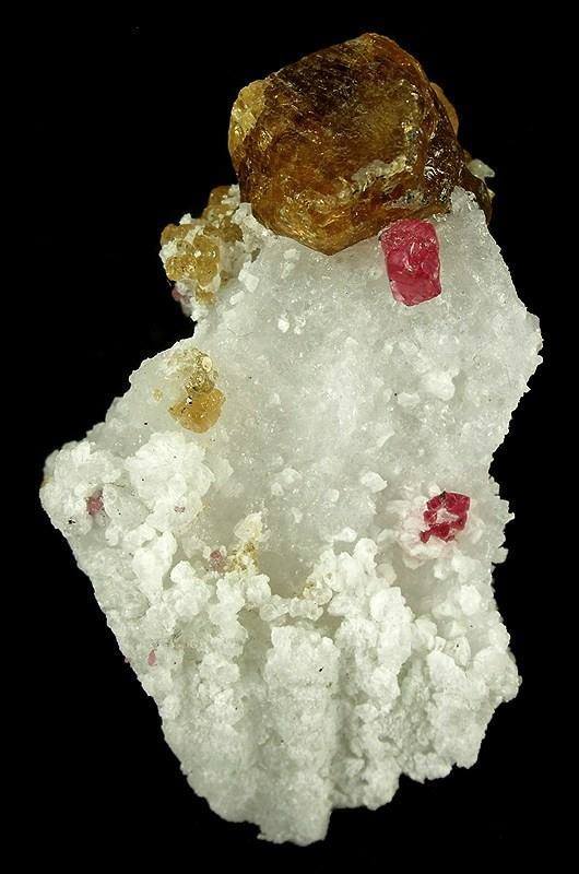
Norbergite
These yellow crystals bear testament to the forces of metamorphism, which transformed the original sea bottom limestone into glistening white marble, concentrating the impurities in the rock into gems. This particular one was magnesium rich, since the marble is dotted with red spinel crystals (magnesium aluminium oxide) along with a larger yellow-brown chunk of normbergite (hydrated fluorated magnesium silicate).
The specimen comes from the Mogok stone tract of Burma, source of the traditional pigeon's blood ruby. The original limestone was transformed from sea bottom to land and limestone to marble by the collision of India with Eurasia that eliminated the eastern half of the near gone palaeoocean Tethys (the other half is but a sad remnant called the Mediterranean as Africa removes its last vesiges).
The mineral is named after its type location from which it was first scientifically described. Unlike the 4.9 x 2.9 x 1.7 cm Burmese example in the photo which was born in what is known as a regional metamorphic event (when a large area of land is transformed in belts that reflect variations in temperature and pressure conditions during a mountain building event), the original material from Norberg in Sweden came from a different kind of metamorphism called contact metamorphism, which occurs when existing rocks surrounding an intruding mass of molten rock rising from the bowels of the Earth are baked and stewed in the igneous juices. The granites (in this case) pushed into carbonate rocks and the last refined water rich remnants of the magma gave up its fluorine as a pegmatite.
The mineral fluoresces in UV light, as electrons are excited by the higher energy and wavelength rays and give up that energy after some time, emitting lower energy visible light wavelengths as it does so. Other sources include the Franklin mines in New Jersey, Canada, Finland and Italy. As well as the colour of the specimen, crystals can also be white, orange or red. The Mohs hardness weighs in at 6.5, between feldspar and quartz.
Loz
Image credit: Rob Lavinsky/iRocks.com
http://www.mindat.org/min-2925.html
http://bit.ly/1NItqgt
http://bit.ly/1KWJncT
http://www.galleries.com/Norbergite
172 notes
·
View notes