#Geography in 1500
Text
Geography in 1500-introduction
It is no surprise people don’t get political situation in Europe at beginning 16th century. We are not taught how geography affected the political situation, and course of history. Yeah on ocasion you get some map, but doesn’t really give you good picture. Often the very important towns or geographical features are missing! Or you don’t know certain places had same ruler.
So I’ve decided to change that and show you how actually things were. I will be doing series of post about Geography/Political situation in 1500, focused mainly on Europe and Northern Africa,
For these posts I will often use map by reddit user Yetkinler:

Looks like complicated mess? Because it was! Actually it was even more complicated that this. It is closest to the actual political-geographical state of Europe that I could find and Yetkinler did truly great job.
However it is literally impossible to depict HRE 100% correct on map of this scale. It was even more complicated than this!
Link(i use the map which is 4 years old): https://pholder.com/u/yetkinler/
(Tumblr won’t allow the map to upload HD, so if you want to get closer look, you have to download it from the link, not from here).
Unfortunately he/she is no longer active on reddit, but I’d still like to give them my thanks.

I will be using Yetkinler’s map, adjusting it to make certain things more obvious.
Also bit of note here about geographical maps in general. Earth is 3D sphere. Trying to recreate continental shapes, and sizes of countries in 2D is never 100% correct. Further from equator, the more distorted things are. I recommend you check the link bellow, where you can move around the countries and see how big they are in comparison to each other!
https://www.thetruesize.com/
It’s mindblowing. Or look up google Earth. It’s wonderful tool.
But back to historical geography, and political situation in Europe. There were several types of goverments. Main ones:
Monarchies, Republics, Confederacies and Teocracies
Hereditary monarchies
Elective monarchies-Holy Roman Empire’s Emperor was elected, but you’d be surprised how many countries technically(in priciple but not in practise) speaking had elective monarchy or nobles had right to chose ruler if ‘need be’.
Republics-Venice for example
Confederacies-for example Swizerland and Livonia
(A confederate government is a group of states, nations or territories that are joined together by a central government that has limited powers of authority.)
Theocratic elective monarchy-Papacy
But teocratic goverment was not exclusive for Papacy. There were also independed archbishopric and bishopric titles, sometimes they were vassals of other rulers or part of confederation.
Holy Orders(military orders) also sometimes had level of idenpendence. Teutonic Knights were vassals of Polish Crown, but other orders were independent.
Same as with republics, some were idependent and others were vassals and only semi-independent.
Another term you should know is primogeniture and partition.
Primogeniture is when eldest legitimate child(usually son) inherites everything, leaving his siblings with nothing. Partition means that highest titles of the monarch gets divided between sons. So each gains their own indipendent land.
It used to be very prominent in Europe’s history but by 1500 it was no longer in fashion. However in 15th century one such partion was very important and imo changed course of Europe forever.
But then there are things which don’t make much sense. Why is Poland a Kingdom, and Lithuania is Grand Duchy, despite being much larger?
Mostly the answer is tradition, country’s history and nobody bothered to change it.
Historically, there was something called ‘petty kingdom’. Good example were Anglo-saxon Kingdoms in England:

Those were petty Kingdoms-which later got replaced by larger Kingdom of England. Problem is, not all larger kingdom lasted. Irish didn’t, and around 1500, still (Petty) Kingdom of Desmond still existed. It wasn’t that much larger than its neighbours, who didn’t style themselves as Kings.
In Iberia, when Navarre was established(first as Pamplona), it was still high times of petty kingdoms, and independent Castile nor Aragon didn’t exist as independent kingdoms.
When they later did, they stopped Navarre from expanding and themselves grew much larger. But at beginning they weren’t that different in size.
That is why Navarre was Kingdom despite being smaller than many duchies, princedoms etc.
Less comprehesible is de jure part of kingdom, and how it affected whetever or not you should call the realm Crown or Kingdom. Because many kindgoms technically speaking should be officially called Crowns instead.
However nowadays people don’t know there was difference and call both kingdoms. Personally I don’t mind either, but I’d like you to know what the difference was.
The issue mostly is whetever or not all their parts were officially de jure part of kingdom. Oficial part.
Idk if you’ve ever played Crusader Kings(game), but in it you can play as any ruler in Europe and conquer land. Your newly gained land, doesn’t become de jure part of your kingdom instantly, but in the game it takes 100 years, to make it official part of your kingdom-
In real life, there were territories owned by kingdoms for over 900 years-which still weren’t officially de jure part of the kingdom, just part of/under the Crown. Even though they had same language, same culture, and literally nothing which would explain why the shift wouldn’t officially happen. No reason at all for Moravia to not be official part of Bohemia. I live here, I don’t get it!
(But it might explain why twice in our history we were shortly not part of Bohemia and rest of the country was not up in arms about it, screaming-this is our land! Give it back!)
Crown instead of Kingdom was also used if the monarch had multiple kingdom titles, usually with first or main one being used. So Ferdinand’s realm was under Crown of Aragon, yet made of several kindgoms. So if you wanted to nitpick or be precise you could refer to one or the other.
‘Crown of Aragon was large and consisted of several kingdoms, but of course Kingdom of Aragon was closest to its rulers heart’. Here you can tell the difference.
But even with this there were exceptions, times when for some reason the term Crown was not used, even though countries were part of personal union(had same ruler). We don’t use Crown of Denmark-but instead Kalmar union.
Union of two crowns could be complicated. Some never got shared name. However instead of Castile-Aragon, they started to call it Spain, refering to it dozens of years of before officially it became Spain. Probably because it was easier in speech.
Usually ducal unions-such as Ferrara-Modena only have - in between. Some people nowadays use &, but I don’t like it(for no reason other than personal preference).
If you still don’t get something in this post, write to me, preferably in messages, because in comments I cannot reply as lenghtly as I’d like to.
I will start with Christendom, but later I’d like to do muslim states too. Silk road, naval trade roads imo have been discussed enough. But I’d like to include trade roads across Sahara, because of how much it affected N. African states.
I’ll see if I’ll eventually do Abyssinia too.
I hope you’ve enjoyed it and if you’d have preferences as to which country/region I should start with, write me in the comments.
22 notes
·
View notes
Text
can anyone tell me why i just thought it would be a good idea to throw myself headlong into a sequence of research & effort that summarizes as "human geography & urban planning historical revisionism" and would require learning how to do a from-the-ground-up redesign of entire metro areas based off of current understanding of the course of technological advancement, finding the oldest topographic data to use, spending hundreds of hours learning to effectively draw/paint semi-realistic architectural & landscape scenes, likely learning 3D modeling whether digital or physical, improving my understanding of building standards/options, and keeping up with emerging technologies.
#i am insane#i have no sense of the commitment it would take#but holy shit#i want to SEE it done#and i doubt anyone else will do it#something something plant a tree twenty years ago#something something the time will pass anyways#but like#where do you even find that kind of data?#i have dug in some deep research holes before#but finding pre-1500's topography surveys#roman empire era geography details?#even i would be out of my depths#let alone the “just learn to draw it” side#i have visual aphantasia#my brain can't see shit#just the void#so any visual art form is incredibly taxing#it's why i struggle to doodle but calligraphy is fine for me#patterns are chill but dynamic reconstruction scares me#and i know i need to practice#learn the basics and drill them#but i feel so worthless when i do that#like all my capacities fail me in that world#hell i have no (real) sense of rhythm but i'd sooner try learning piano than art#but everything i WANT to do requires some artistic capacity#_(:‚‹」∠)_
3 notes
·
View notes
Text
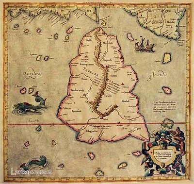
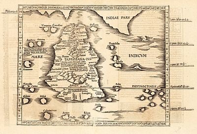
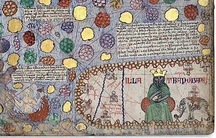
Three different maps of Taprobane Island
modern Sri Lanka,
as known to the Ancient Greeks
1. Ptolemy's Taprobane
2. Ptolemy's Taprobana published in Cosmographia Claudii Ptolomaei Alexandrini (1535)
3. Taprobane in the Catalan Atlas (1375): "Illa Trapobana"
#art#archaeology#maps#medieval#ancient#taprobana#taprobane#taprobane island#taprobana island#sri lanka#1500s#1300s#16th century#14th century#geography
1 note
·
View note
Note
what does your username mean?
Cat ghost.
As child. Would go to library, to look at books about creatures, with a pen and notepad. Or sit before a television watching "nature" documentary stuff, with a pen and notepad. Was fixated on habitats. The context. Did not like to isolate an individual creature from the wider ecological community. This led to interest in geography, distribution range maps. Was aware that, in popular perception, some creatures were strongly associated with a particular place. "Lion is an African animal. Tiger is an Asian animal." Allegedly. And other stereotypes (many of them, I would later come to learn, due to chauvinism, exoticism, Orientalism, colonialism, etc.). Came across a kind of large textbook on wild cats. Saw the historical distribution maps. Only a few centuries ago, tigers were in Anatolia, the Caucasus, near the shores of the Black Sea. Was intrigued. From the middle of the twentieth century onward, the lion and cheetah were so closely associated with Africa, where like over 99% of their range was located. And yet. There remains a small remnant population of nearly-extinct Asiatic lions far away within India''s borders. And there remains a small remnant population of nearly-extinct Asiatic cheetahs within Iran's borders. And all that space, in between, where both cats were now extinct. Only 100 years ago, tiger, lion, leopard, and cheetah all lived generally near each other, still, in eastern Anatolia, near Mesopotamia, etc. And now, only a few dozen wild native cheetah remain on the entire continent of Asia.
"Cheetah". The word for this cat is from South Asia. Through Hindi, from Sanskrit.
"What happened?" I read on. Cheetahs were present within the national borders of what is now India, along with tigers, lions, and leopards. By the 1500s, there was a tradition in South Asia, where some in the Mughal aristocracy enjoyed using cheetahs as companions in sport hunting. The cats would be captured in the wild, and then trained, and then brought along on royal hunts. The cat was the star athlete, goaded into chasing down prey, for the entertainment of the hunting party. There are elaborate paintings, commissioned by Mughal courts and some now displayed in collections of European museums, depicting trained cheetah hunts. It has since been popularly said that Akbar was particularly fond of cheetahs. (Akbar the Great was the "emperor" who is credited often for consolidating Mughal state power across India, solidifying regional power by building administrative systems/structures in India ["forging an empire out of fiefdoms"] that would later eventually be manipulated and overtaken by the British Empire. According to some tellings of the historical narrative.)
Accurate or not, it was said that at any one time, Akbar possessed one thousand cheetahs. A vast royal menagerie. The names of several of the most celebrated cheetahs are still known. In some stories, when he was still young, Akbar was presented with a gift. His very first cheetah: Fatehbaz.
This disturbed me. A child, reading this book, I was upset by the idea of such a vast menagerie of wild animals. Large wild animals, with great need for food, space, enrichment. I was upset by the exploitation of captive wild animals as displays of aristocratic wealth, not just in the Mughal state(s), but also those menageires and exhibitions elsewhere, both earlier and later in time: the royal hunts of Assyrian kings, the Roman arenas, Charlemagne's elephants, European circuses.
So, as a child, I imagined that Fatehbaz resisted the captivity. Like in a daydream, a fantasy. I imagined a royal menagerie breaking free from restraint. I imagined elephants and rhinos and tigers and lions and leopards and jackals and crocodiles. I imagined the beasts attacking an emperor's court. But there are now less than one hundred cheetahs which survive in the wild in Asia. And when Mughal statecraft gave way to European statecraft, when Britain moved into South Asia, the bounty hunting specifically targeted big cats. And, meanwhile, the cats were confronted indirectly with habitat destruction, commodity crop monocultures, industrial-scale resource extraction. So I came to imagine the ghosts of cats. The ghost of a cheetah like Fatehbaz on the Indus plain. The ghost of a jaguar in the Sonoran desert. The ghost of a lion on the Mediterranean coast. The ghost of a tiger on the Amu Darya shore beyond Bukhara, where even the Aral Sea itself has vanished.
123 notes
·
View notes
Text
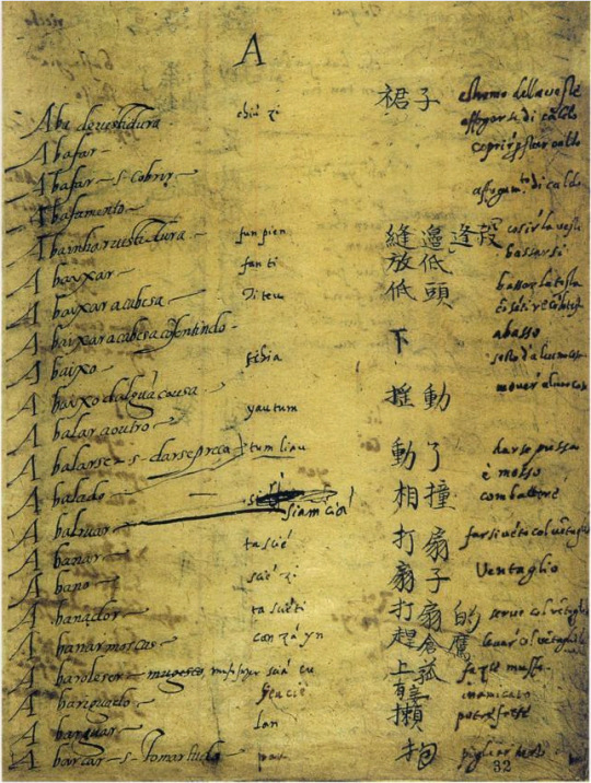
Jesuit missionaries were some of the first westerners to enter China in the 1500s. They made a sincere attempt to understand Chinese culture.
One of the Jesuits’ first projects was to learn Chinese in order to translate Western works into Chinese and vice versa. Here’s a page of a Portuguese-Chinese dictionary compiled by two Jesuits, Matteo Ricci and Michele Ruggieri:
The Ming were particularly interested in the Europeans’ knowledge of geography — it was the age of European exploration, after all. Jesuits like Ricci provided the Chinese with very detailed maps of Asia:
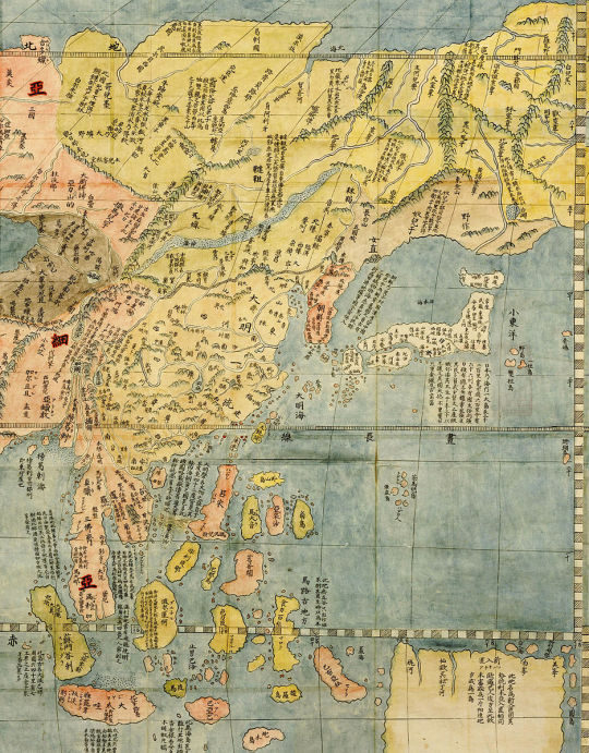
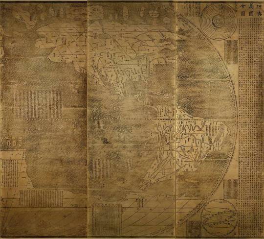
Chinese people were just as fascinated with the discovery of the Americas as Europeans were, so the Jesuits filled them in on what was known about the lands across the Pacific:
{WHF} {Ko-Fi} {Medium}
203 notes
·
View notes
Photo
Renaissance Architecture
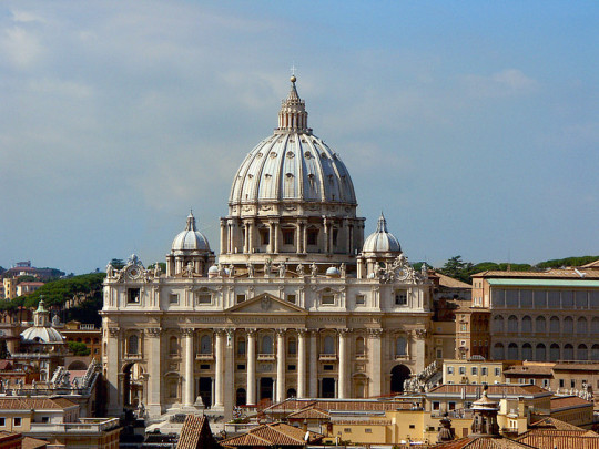
Renaissance Architecture originated in Italy and superseded the Gothic style over a period generally defined as 1400 to 1600. Features of Renaissance buildings include the use of the classical orders and mathematically precise ratios of height and width combined with a desire for symmetry, proportion, and harmony. Columns, pediments, arches and domes are imaginatively used in buildings of all types.
Renaissance masterpieces which influenced other buildings worldwide include St. Peter's Basilica in Rome, the Tempietto of Rome, and the dome of Florence's cathedral. Another defining feature of Renaissance architecture is the proliferation of illustrated texts on the subject, which helped to spread ideas across Europe and even beyond. The Renaissance style was frequently mixed with local traditions in many countries and was eventually challenged by the richly decorative Baroque style from the 17th century onwards.
Renaissance architecture was an evolving movement that is, today, commonly divided into three phases:
Early Renaissance (c. 1400 onwards), the first tentative reuse of classical ideas
High Renaissance (c. 1500), the full-blooded revival of classicism
Mannerism (aka Late Renaissance, c. 1520-30 onwards) when architecture became much more decorative and the reuse of classical themes ever more inventive.
Historians rarely agree on exactly when these changes developed and much, too, depends on geography, both in terms of countries and individual cities.
Studying the Past
The Renaissance period witnessed a great revival in interest in antiquity in terms of thought, art, and architecture. The first and most obvious point of study for Renaissance architects was the mass of Greco-Roman ruins still seen in southern Europe, especially, of course, in Italy. Basilicas, Roman baths, aqueducts, amphitheatres, and temples were in various states of ruin but still visible. Some structures, like the Pantheon (c. 125 CE) in Rome, were exceedingly well-preserved. Architects studied these buildings, took measurements, and made detailed drawings of them. They also studied Byzantine buildings (notably domed churches), features of Romanesque architecture and medieval buildings. For many Italian architects, the Gothic style was regarded as an invasive 'northern' invention which 'corrupted' Italian traditions. In many ways, then, Renaissance architecture was a return to Italy's roots, even if medieval architecture was never wholly abandoned.
A second point of study was surviving ancient texts, most particularly, On Architecture by the Roman architect Vitruvius (c. 90 - c. 20 BCE). Written between 30 and 20 BCE, the treatise combines the history of ancient architecture and engineering with the author's personal experience and advice on the subject. The first printed editions came out in Rome in 1486. Renaissance architects pored over this work, studied the emphasis on symmetry and mathematical ratios, and in many cases, even tried to build structures that Vitruvius had only described in words. Perhaps an even greater effect was that Vitruvius inspired many Renaissance architects to write their own treatises (see below).
Continue reading...
26 notes
·
View notes
Text
@transgenderer wondered the other day about the earliest non-elite, non-officer account of war. I was also curious about the question, and @mynodon generously volunteered a PDF of "British Diaries" (William Matthews, 1950), which I had brought up.
Going through the list, there are a number of military diaries from before the English Civil War, the earliest being from 1544. These tend to be short, impersonal, journalistic, and focused on specific expeditions and campaigns. None seem to have been written by anyone who could be described as low-status; a few of the anonymous entries looked promising, but, on tracking them down, I find that not one provides a first-person account from the point of view of a common soldier or sailor.
On the other hand, civilian diaries of the period are sometimes quite personal, and their authors increasingly include tradesmen, yeomen, and local clergy, though elite accounts still predominate. There are several by astrologers.
When we hit 1642, things get a little denser. I am satisfied that this catalogue contains no examples before that year, which would postdate the account of Peter Hagendorf anyway.
I also had a look around at some of the general works on autobiography I used at university and didn't find anything substantive or specific. I wasn't really focused on military issues at the time, and none of the authors drew attention to specifically plebeian military perspectives, though one (McKay, "English Diarists: Gender, Geography and Occupation, 1500–1700") says there are diaries from "all ranks" (though, again, "not an officer" doesn't mean "not elite", there's one diary from a non-officer member of the King's life guard).
So it seems the earliest account is unlikely to be in English, which makes sense given the relative peacefulness of English history between the end of the Hundred Years' War and the beginning of the Civil War. (This being relative to the continental wars of religion, of course.)
One possible "edge case" is writers who wrote memoirs from memory after becoming high-status — Bernal Diaz's Historia verdadera de la conquista de la Nueva España begins its narrative with the author as a common footsoldier, but it was written 50 years after the fact.
17 notes
·
View notes
Text
Allah created stars and constellations as a guide for travelers
December 18 is the World Arabic Language Day, let us prepare to celebrate the Language of Quran by looking into the contribution of Arabs into the modern civilization. Its all started from the rich literature in form of Quran to science and technology to medicines and geography, astrology and space science, globe and pottery, architecture to history and above all the constitution for humanity. Arabs discovered everything and their contribution in every field is amazing and surprising because those are not disclosed and propagated by medium. This is a very big chapter. Presently we are discussing the creation of Universe by Allah.
1500 years ago, Allah revealed the purpose of the creation of the stars and constellations. Quran reveals, “And He is the One Who has made the stars as your guide through the darkness of land and sea. We have already made the signs clear for people who understands. (6:97)
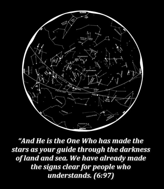
Surprisingly, even today the sailors and pilots after using of both constellations, radars and compass for navigation the plane with passengers vanishes or lose its way. The reply is simple. Its Allah who guides us both in sea, land and space. Verse (16:79) clearly reveals, “Do they not see the birds made to fly through the air in the sky? Nothing holds them up except Allah. There truly are signs in this for those who believe and understands”.
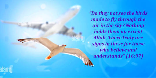
And if Allah misguides no one can guide. Its all beyond the control of humans although it seems so. And to Allah belong the unknown secrets of the Heavens and the Earth.” (11:123). “And with Him are the keys of the Unseen that no one knows except for Him.” (6:59).

“Say, O’ Muhammad(ﷺ) no one has knowledge of that which is hidden in the Heavens and the Earth except for Allah.” (27:65). O Prophet (ﷺ), you cannot grant guidance to whom you please. It is Allah Who guides those whom He will. He knows best who are amenable to guidance.(28:56)
21 notes
·
View notes
Note
Reading your characters profile, I realize you never mentioned their date of birth. Can you tell me the year or time period that the characters (USA, Australia, Ireland,….) be born?
So I kind of did that on purpose because its one of those things that people have their own very specific headcanons and versions and I don't feel that strongly about it because there's multiple ways to go about things and I've changed my mind about this couple of times but generally I go with the earliest reference to a culture emerging I can find. The idea of a nation rather than the hard founding dates because there are more to these things than just when a European stepped foot somewhere. And full disclaimer, when I don't have writing to use, I'm using archaeology and artistic expression as what that idea might have been. Also I think if I were to rewrite this now, but I don't want replace a lot of existing writing I would make them born much later but fuck it, here we go. Also I had so many links to put in this but I lost them so eh, there's one lmao fuck my entire life im so tired.
Britannia/Eirian — 1500-1000 BC. I'm kind of bullshitting because geography and history are hard to do when there's like 2 pieces of Roman propaganda that survive. The National Museum of Wales says the Celts arrived about 1000 BCE so that's when she found herself rooted in the British Isles. She might be older than that.
Ireland/Brighid — 600-400 BCE. again we're working with what's in a lot of ways prehistory here so the earliest example I could find of what archaeologists identified as a distinctly Irish take on broader artistic styles. Particularly in ironwork. There's a spearhead that was found in the River Inny that is of a style recognisable in medieval Ireland but carbon dated too before 500 BCE.
Scotland/Alasdair — 600-400 BCE. The archaeology suggests a a population increase and an artistic coalescing as temperatures warmed and some new prosperity allowed new pottery styles, increased use of horses came along and allowed the very earliest brochs or stone towers mostly found on the coastlines of Scotland seem to date to this era.
Wales/Rhys — 400-300 BCE. Literally based this off one of my favourite torcs found in Wales and that's as good as I've got send help.
England/Arthur — 50BCE-100 AD. Roman Britain get jiggy with it just wanted a couple of centuries between the baby bilge rate and his siblings.
America/Alfred — 1580s. The first reference I ever saw to America being associated with new opportunities and money making and protestant havens was 1585.
Canada/Matt - 1610s. The first reference to Canadians being different from European Frenchmen was in the 1610s so Matt popped out around then. The French unlike the British or Spanish were less attentive to the claims they made on Canada but then didn't settle for nearly a century.
Australia/Jack — 1790s. Australians as a concept was the late 1790s with some of the first references made by Gaelic speaking Irish prisoners.
Aotearoa/Zee — 1810s. She's a little harder because there's a lot of escaped prisoners, whalers and other random white people living with Māori before the Brits properly showed up but I'm just rolling with it.
26 notes
·
View notes
Text

Ajareaty Waiapi by Allison Adams
"Some time ago, we lived well; we did not worry about land. We did not know we would have many invaders, loggers and prospectors in the future. Many talk about our land today, they say that they want to take our land.”
Ajareaty Waiapi (aka Nazaré) is the chief of an indigenous village in the Brazilian Amazon Rainforest—an area which is home to 900,000 indigenous people (around 305 tribes) At 38 years old, Nazaré decided to learn Portuguese so she could “talk with the white men in meetings” and advocate for her land and people with the lawmakers of Brazil. Her commitment to learning at an older age (and in the face of some ridicule) earned her the honor of chief, a rare role for women, who don’t often get educations. At 58, she started attending a high school geography class to better understand her people’s land as it relates to the rest of the world. She’s also encouraging all the Waiapi people (nearly 1500 people in 92 small villages) to go to school in order to protect their land, their rights to education and healthcare, and their traditional way of life, which are under threat by the current Brazilian government (whose leader has long resented the protection of indigenous land and has encouraged the deforestation of the Amazon.) Over 87,000 fires (most of them illegal) have started in the forest within the past year, a number that has nearly doubled since Bolsonaro took office.
#Ajareaty Waiapi#Nazaré#Allison Adams#indigenous women#art#artwork#female portrait#sheroes#female activists#Brazil#amazon rainforest#irl women/girls
2 notes
·
View notes
Text

and since i posted that letter that references carié isle i thought id post (one of) my current ref/design for the isles geography! carié is less so an island, and moreso the emergent peak of an underwater mountain chain. it has a population of about 200 permanent residents (and nearly 1500 goats my beloved goats) and the entire island is hollow on the inside, with homes carved out into the outer wall of rock. ill post some more pictures of places in carié and its inhabitants later but here goes for now!
11 notes
·
View notes
Text
Geography in 1500, England-Part 1-basics
I myself was wondering how all the land under English Crown was divided in Tudor times. Except from 1510 sumptuary law gives a clue:
“That no one who does not possess the title of a lord, and who is not a Knight of the Garter, may wear any woolen cloth manufactured outside of England, -Ireland, Wales, Calais or Berwick, "or the marches of the same."
Hence according to Tudors English Crown consisted of England, Ireland, Wales, Calais, Berwick + the marches(which were within England).
Not Marshes as this:
But as border areas. There were two marshes-Welsh Marsh, next to Wales. Ludlow was located in Welsh Marsh-hence technically still within England, and then there was Scottish Marsh in the North.
Ireland had lots of indenpendent territories which didn’t aknowledge Tudor rule at all, and then English Pale, but I’ll do separate post about Ireland itself and explain more in detail there.
Wales was once idenpendent but even before War of Roses fully under the control of English.
Calais is city nowadays in France, but it was English right until reign of Mary I. It was english enclave and important trade connection between island England and continent.
By the way, it wasn’t formerly part of Normandy, it’s bit more up North from that...and was actually captured by English in 1347 and stayed English until 1558, when Mary I lost it to France.
You probably knew all of that. But what the hell is Berwick?!
Well, actually there are several towns called Berwick.
I believe the record is talking about Berwick-upon-Tweed(or on the Tweed).
(Historically it was called by Scottish as South Berwick, because they also had another town called Berwick more North, which they called North Berwick).
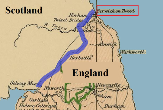
A town on Scottish/English border, over which they fought many times and it changed many hands. But it seems the town had different status than any other town, and in 1551 Berwick was declared to be free town, indipended from either Kingdom. In practise controled by English, but had independed borough, outside of authority of any English county. The wording of sumptuary law in 1510 suggest Berwick had similiar status even long befor this.
(Maybe just not officially.)
It was sort of enclave, like Calais, with special rules.
Interestingly the town was offered by Margaret of Anjou to Scottish in 1461(for their support) and before Richard III proclaimed himself king, in 1482 he recaptured the town from Scottish. Scottish didn’t accept this conquest, in their documents it was still Scottish many years later, but in practise the town remained English ever since. Elizabeth I spent massive funds for fortification of the town. So clearly it was very important.
Until Scottish and English crown united in 1603.
And then there are/were islands. And quite often it is mentioned in records(or on wikipedia) that somebody (nobles) in times of distress(like political situation being unstable) would seeking shelter/refuge upon these islands...
If the island was separated only by narrow strait from mainland, it was much easier to govern, and was offically part of the mainland territory.
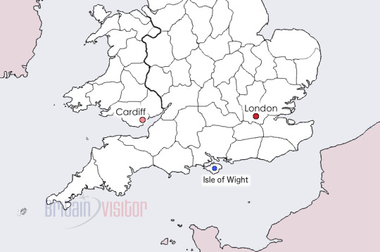
For example to the South of Englad we have Isle of Portland(source of Portland marble) and Isle of Wight. They were part of Kingdom of England.
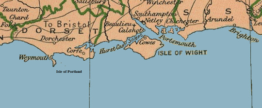
Isle of Wight again:
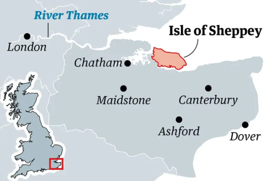
To west of London is Isle of Sheppey:
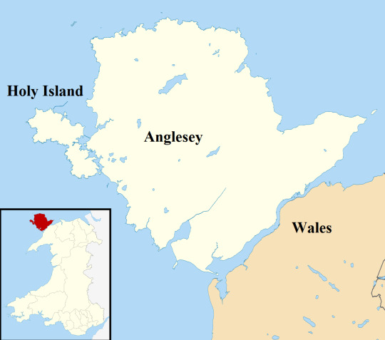
And to N-W of Wales is Anglesey and Holy Isle-which were part of Wales:
But what if Island is further away?
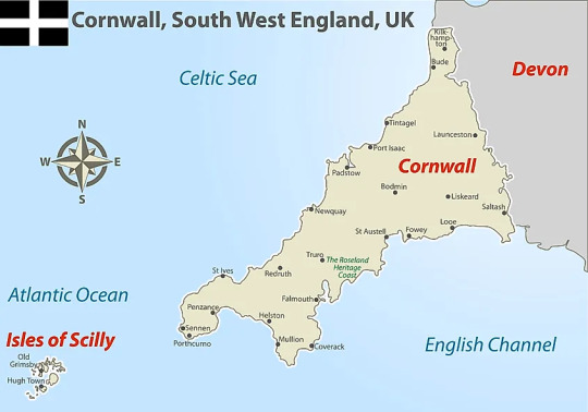
To West of Cornwall(S-W England) are Isles of Scilly:
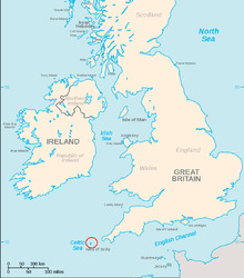
Also called Sorlingas (Spanish, Portuguese) or Sorlingues (French). In the Cornish language, the Isles of Scilly is Syllan.
They are further away, but still under control of English since before 1000, and were part of England.
However, there are islands, which never became part of English Kingdom(nor Wales) but were under English Crown. For centuries.
Nowadays they are the dependencies of the British Crown(not to be confused with overseas crown depencies) They are still under same monarch, but have their own goverment, passport etc.
Some of them now claim they had special status since medieval times, it is not confirmed as far as I know.
But due to them being further from England, it is likely they had some level of automy and special governing from before Tudor era. Even if it wasn’t offical. They are simply not close enough to any mainland coast for it to be easy to control them. But probably because it wasn’t official that Sumptuary law didn’t mention them. (It could be just traditional...)
-Isle of Man, which is located in Irish Sea between Ireland, Scotland, Wales and England:
In past it was conquered by vikings, and in 13th century Scottish King bought it from Norway in 1266, but in 1290 English seized it. In 1313 Scottish retook it, and then for rest of 14th century it kept changing hands. But by beginning of 15th century it was in English hands and would be ruled by Stanleys.
-and the bigger of the Channel Islands(not to be confused with Californian Channel Islands).
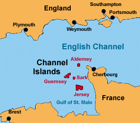
I am talking about islands in English Channel(La Manche, sometimes they are refered to as Norman Islands, and that is pretty accurate.
The channel islands originally belonged to Duchy of Normandy and when English lost the mainsland Normandy and they managed to keep those islands.
-Biggest islands being Guerseney, and Jersey and then smaller Alderney, and many smaller islands:
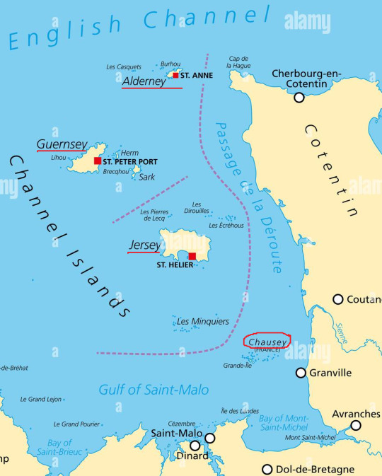
But that is not entire story. Because English kept the bigger ones, which are now considered Channel Islands, but during Tudor times, English abandoned the smaller Chausey islands and eventually French took hold of them.
On wiki you can find that Chausey Islands were administered from Jersey until 1499, when the Jerseymen abandoned it to the French for reasons unknown. The Jersey historian Alec Podger has suggested that it was too costly in terms of money and manpowower.
Addionally I am truly confused in how Channel Islands are described nowadays. Because I literally never came upon word bailiwick before.
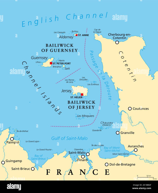
There is Bailiwick of Jersey and Bailiwick of Guernsey. That’s their official name. But what is it? Well, I read the definition several times and I am no wiser.
Best I understand it(and I might be completely wrong) it is Administrative term originating in french language, which sort of groups those islands together under the name of the biggest island. Sort of like town of Buckingham gives name to Buckinghamshire, but with islands.
If somebody understands it better, I am all ears.
Another thing you should know, that English coast nowadays and back then is not same. From Arthurian legends you probably know erosion occured on big scales even back then! (One of Arthur’s knights was prince of Kingdom West of Cornwall which sank under sea.)
But strangely the coast also can grow bigger.
WHAT?! What the heck you mean?’ -you asked.
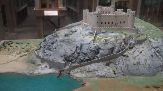
Allow me to demonstrate-this is reconstruction of Harlech castle(in Wales)-how it used to look:
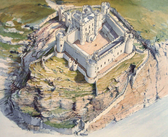
In botton of the picture you can see it had access to the sea, and it could be supplied by ship. Maybe this is better:
And this is current view from Harlech castle from google maps:
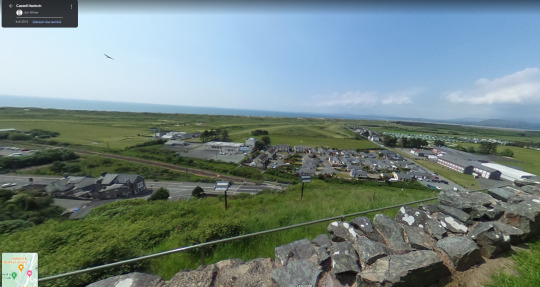
The sea is several km away and there are many buildings in places where once the sea was. Overtime sediments build up in the place, and coast grew!
It’s not the case that west coast grows and East disappears, it’s more complicated than that...But important is, the coast is changing and if you ever time-travelled, be aware.
So I hope you’ve learned something new from this.
5 notes
·
View notes
Text
It’s For You
It is now safe to say that we have an entire generation that has known cell phones their entire lives. They have never felt the need for a land line. They have always had a phone in pocket or purse, ranging from 10-key flip phones, to sliders, Blackberrys, and more recently, smartphones.
I’m talking about Generation Z, of course, the social cohort whose demarcation year—1997—is considered the point after which online life had become nearly ubiquitous. What those demographers overlooked, though, is that this was about the same time that cell phone ownership became nearly as common. While we can all take some credit in this, Gen-Z quickly realized that these phones are for more than just talking or texting. They are lifestyle devices.
I got my first cell phone in 1994, a Motorola bag phone that had to be tethered to both vehicle power and a rooftop antenna. It was basically a heavy walkie-talkie, but it worked. And boy howdy were the fees high. I paid by the minute, which went down a little bit in the evening. Suffice it to say, I only used it for very important calls.

What most people don’t realize is that the first cell phone was introduced in 1973. Marty Cooper is credited as being the inventor, the visionary who saw the need for mobile communications. But the wheels had already started rolling at least a decade prior, because the Dallas Police Department already had dictaphones for squad car and motorcycle cops when John F. Kennedy was assassinated in 1963. They relied on a cellular network much like that which we have today, albeit with much less clarity.
It’s just that it took a long time for this product to diffuse, primarily because of cost. They required development of an entirely new infrastructure, one which we are still trying to complete. I laugh at T-Mobile’s ads that say they have 99% of all Americans covered. Right. If they all stay home. The ad says nothing about how much (or how little) geography they have covered, which we have all discovered whenever we fall off the grid out west.
But now Mr. Cooper, still a visionary, predicts a future in which we will all have cell phones implanted under our skin. Cue the Biblical prophesies of end times and all that once more. It’s one thing to envision using our palm print to buy at an Amazon store. It’s quite another to imagine our iPhone embedded in our body.
It’s not like others haven’t already tried to go down this road, but it was with wearables. Google Glass was a well-intended but poorly deployed set of eyewear that could function much like a smartphone. It landed with a $1500 thud in 2013. More recently, there is the collab between Meta and Ray-Ban that has yielded similar glasses.
But wearables have always been more about the hype than the hope for a better user experience. They still have a long way to go, which may have served as impetus for Mr. Cooper to picture a phone that was not just on our body, but also in it.
Of course, this leaves a lot of other unanswered questions, because without a visual aspect, it just becomes another Alexa device. We need screens somewhere, which necessarily involves a handheld device, or perhaps holograms that are projected before our eyes. Now it’s time to cue the crashes and missteps.
And how might we issue orders? By merely thinking of them? Or would we have to actually say something, kind of like we do with our digital assistants today? And if we are texting to someone, would we similarly have to enunciate it and rely on voice dictation—which can be dangerous—to get the job done?
Now imagine the ability to merely “think” something into action. Or being able to instruct the computer that is inside your head to access ChatGPT and have it compose an essay while you are finishing an in-class exam. Of course, you’d have to be able to download it somehow, but those are mere details. And consider social media. We might be able to post content, as well as click the Like and Heart icons without ever tapping a finger. The possibilities are limitless.
By now you have probably detected that I am poking a little fun at this notion. Truthfully, I consider it just a bit absurd. Well, I once thought the same of the first iPhone, but a year later I drank the Kool-Aid. I have guzzled it ever since, and I bet I could just as easily drink from this fountain as well. I think Mr. Cooper’s idea needs some fine-tuning and then selling. It could take a few years, maybe decades.
Just like the first cell phones needed a quarter of a century before they took off. Innovations can be like that. Gen-Z can say they were at least here for the beginning of the conversation of the embedded phone, but there may be a couple more generations down the road before one emerges that can lay claim to having lived their entire lives with it.
And now I am left trying to figure out what my generation can claim as ours. I’m thinking color television and microwave ovens. They’re not much, but they were a start, and we embraced them. You’re welcome.
Dr “We Were Simple Like That“ Gerlich
Audio Blog
2 notes
·
View notes
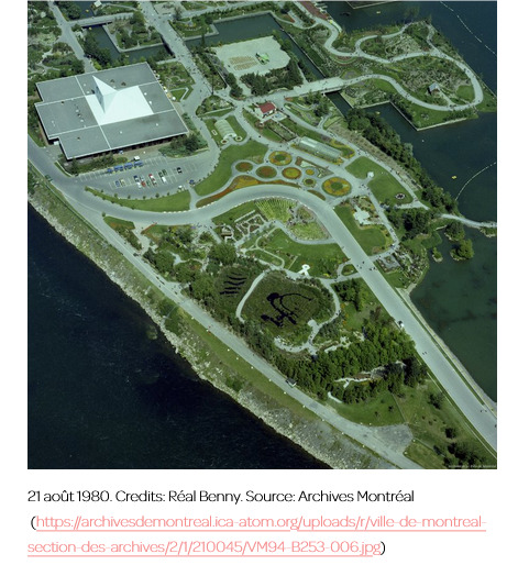
Text
Montreal is a city animated by a lingering cosmopolitan phantasmagoria, especially its two ‘man-made’ islands, Île Sainte-Hélène and Île Notre-Dame. Built to host Expo 67, a colossal World’s fair resting on dredged soil and urban debris, they became the experimental landscape and socio-technical matrix of the future megacity Montreal dreamt of being. This event crystallized the city’s image as the avant-garde “capital of the megastructure,” a concept which redefined (urban) spaces as dynamic relationships between people, technology, and dwellings, “coded [...] by notions of process” akin to those of the organism (Riar 2020, 200). Thirteen years later, the Floralies Internationales de Montreal was held in the wake of “Man and his World,” the fair’s permanent exhibition on Île Notre-Dame. The 8th International Horticultural Exhibition invited citizens to admire “the world’s most beautiful botanical garden” representing the cultures of twelve nations, including Canada. [...] The organizers viewed the gardens as “soft technologies,” designed to beautify the city while benefiting its economic and cultural sectors. [...]
[Gardens] offer “profound insights [...].” They are “sites where people explicitly stage [...] their relationships with nature” [...]. Gardens not only inform what [...] dwellers find valuable and good, they organize the political and economic relations urban centers cultivate - or not - with their peripheral others -- rural lands, ‘nonhuman’ life and ‘nonlife’. Botanical gardens, such as the Floralies [...] are not merely displays of state power and scientific knowledge, but technologies [...] that operate by transplanting alien ecological - so-called rural - habitats into the hybrid spaces of a metropolis.
And while we could frame this dynamic within urban/rural or center/periphery binaries, I contend that what made the Canadian garden a garden in 1980 was precisely its relationship to what lies far beyond the theoretical scope of such binaries - that which eludes rigid biological and geographical inscriptions: wetlands. What follows is a meditation about murky and precarious dwellings. And about binaries, and the relentless oscillations that govern places of belonging. It is an invitation to consider urban and rural geographies and all that lies beneath and beyond their preference for the living.
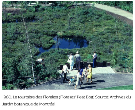
And it is the story of a northern peat bog that was “transplanted” to Île Notre-Dame in 1979.
“A little bit of James Bay in Montreal”
It took a fleet of trucks fifty 36-hour trips to haul half an acre of James Bay to Montreal. That “little bit” of Northern Quebec was more precisely 1300 frozen blocks of peat taken from the Hélène Lake bog, near the construction site of the LG2 hydroelectric project. [...] The blocks [...] were then reassembled [in Montreal] [...]. To ensure that the Notre-Dame peat bog bloomed in time for the Floralies, a year later, gardeners carefully monitored water and acidity levels [...]. The garden's “spongy consistency,” created by a combination of sphagnum mosses, tamarack, black spruce, hairy honeysuckle, round-leaved sundew, and Labrador tea, amongst 50 northern species, could be admired for the first time in Montreal’s temperate climate, a stark contrast to the hydrogeoclimatic conditions of James bay, 1500 km away [...]. In 1980, thirteen years after Expo 67, the bog was fully integrated as yet another dynamic process in the city’s “organic” megastructure.
Why did the chief horticulturist of the Montreal Botanical Garden choose to represent the “nation” with a northern peat bog?
Because Canada was, and still is, home to a quarter of the world's wetlands, which had already been massively drained for agriculture and urban sprawl. The garden's purpose was to bring the ecological benefits of these threatened ecosystems to an emerging environmental awareness.
Montreal, which used to be completely surrounded by “swamps and boggy places” [...] considered unsanitary in the 19th century, destroyed much of the riparian wetlands in the St. Lawrence Lowlands, eliminating 80% of its marshes [...]. The stinging irony is that manufacturing the islands for Expo 67 “was one of the single most damaging projects” for the surrounding wetlands (ibid.). So how could they be celebrated as part of a national heritage? [...]
“Canada is the wetlands settler country par excellence” (Giblett 2014, 11), as, much like Montreal, most of its early settlements were built alongside marshes. Its colonial literature has long portrayed these places as murky, monstrous, and ominous.
In the dominant cultural paradigm, marshes were seen as wastelands, which licensed industries to dump toxic waste in their waters or to drain them (35). Seen as dead and inauspicious lands, swamps, marshes, and bogs posed a threat to colonial powers, while being particularly difficult to map, as water and land were inextricably linked. Peat bogs especially are dense and viscous worlds where mosses thrive on top of their own decaying shroud, a process reaching back into the Carboniferous era “when swamps ruled the earth” (203).
---
This story of a garden made of moss not only reveals how Montreal discredited the way the Cree community valued and used wetlands, but offers insight into the colonial governance of Canada and Quebec. [...]
Ultimately, representing peat bogs as “barren lands” speaks to the political figuration of all that is not urban, or, in Giorgio Agamben’s words, as bare life, which, in Western politics, “has the peculiar privilege of being that whose exclusion founds the city of men,” ordered by the “good life” (Agamben 1998, 7). To be preserved, the elusive and ominous peat bog had to be transplanted to the city, where it could be a tamed vehicle [...].
Rethinking geographies beyond anthropocentric [...] views of what defines urbanities and ruralities, might allow us to better understand the constitutive exclusions that created this binary in the first place. In Canada, both urban centers and rural regions have been constituted through the destruction of wetlands. This was repeated in the 1980s, when, just two years after the Floralies championed the city’s green turn, the Notre-Dame peat bog was abandoned. Today, if you were to go there, you would find a dried-out pond, where meridional species have reclaimed their rights.
But perhaps its disappearance from the city's landscape is a sign that wetlands remain unsettled and unsettling.
---
Text by: Isabelle Boucher. “Urban Mires: What Happened to the Garden of Moss?” Heliotrope, Environmental Media Lab at the University of Calgary. 19 April 2023. [Bold emphasis and some paragraph breaks/contractions added by me. Images and captions are shown as published with Boucher’s text in the same article.]
50 notes
·
View notes
Text

It's December 27th, 🐼 National Visit the Zoo Day in the United States! The earliest type of zoo, the menagerie, dates as far back as 1500 BCE in Ancient Egypt. Egyptian Pharaohs and famous kings such as Alexander the Great, Solomon, Nebuchadnezzar, and Moctezuma also kept menageries. Menagerie ruins have also been found in China and throughout the ancient Roman Empire.
The first modern zoo was built in 1793 in Paris. Soon other cities all over the world followed. By the 19th century, science and geography had joined religion as central pillars of society. People naturally desire to see exotic animals from all over the globe and study their anatomy and behavior. These early modern zoos were like museums of living animals kept in small display areas.
Today's 2,800 zoos and zoological parks across the planet attempt to function as natural habitats for the species they house. They educate and entertain six million people each year, while also furthering scientific research and the conservation of species and their habitats.
Zoos are necessary because they educate the community, provide an understanding of the interdependence of animals and their habitats, and conduct conservation programs of animals in the wild, including breeding programs designed to reintroduce endangered species back into their natural environments. Enjoy your visit today and every day! ☮️ Peace… Jamiese of Pixoplanet
#Jamiese#Pixoplanet#visit the zoo day#visit the zoo#zoo#animals#wildlife#wild animals#zoolife#zoo animals#we went to the zoo#saving species#conservation education#zoos#wildlife conservation#zoo photography#zookeeper#conservation#zoo day#nature photography#zoo world#wildlife on earth#wildlife planet#conservation matters#wildlife photography#national visit the zoo day#nature#australia zoo#natural habitat#nature lovers
3 notes
·
View notes
Last Seen Blogs

queerkidsqueries
Queer Kids' Queries

thecbdoilonline
Untitled

eventtrailltravel
Event Traill Travel

taptapondatass
Gym Bot

sfbing
Untitled