#historical geography
Text
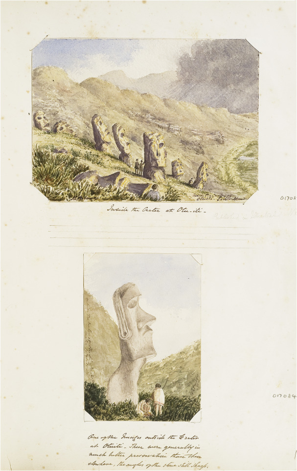
John Linton Palmer, Sketches of moai on Rapa Nui (Easter Island), Nov 1868, watercolour, Easter Island Album, F030/6 © RGS-IBG.
Above: ‘Inside the crater at Otu-iti’ (pencil annotation: ‘Published in Illustrated News’).
Below: ‘One of the images outside the Crater at Otuiti. These were generally in much better preservation than those elsewhere, the angles of the stone still sharp’.
"Linton Palmer’s later sketches indicate an enduring interest in forms of material culture, architecture and archaeology. In 1863, for example, he took leave from HMS Melville to travel for three weeks up-river from Canton with a fellow-doctor William Kane, Scots businessman James Banks Taylor, a missionary Orientalist (and the future Oxford Professor of Chinese) James Legge and his Chinese secretary Tsang Kwei-Hwan. Linton Palmer sketched Buddhist temples and pagodas along the way, although they were not included in a subsequently published account of the trip. Drawing was also to play a significant role in his later studies of the ethnology and geography of Rapa Nui, arising from HMS Topaze’s visit there in November 1868. Although he appears to have included drawings with a letter sent to England the following month, Linton Palmer’s account was published by the Ethnological Society without the drawings, as was another paper presented to the Royal Geographical Society. Nor did his sketches of the skulls (which were sent to Thomas Huxley) appear in print. At least one of his drawings from the Topaze was published in engraved form in the Illustrated London News before his return to London (20 March 1869), and other sketches may have reached wider public audiences in the same way.
...
Today Linton Palmer’s most well-known sketches are those he made on the island of Rapa Nui (Easter island) in 1868, during which one of the moai, Hoa Hakananai’a, was excavated from its underground resting place. The evidential quality of Linton Palmer’s writings on Rapa Nui have been questioned by later archaeologists, especially his supposed tendency to rely on what is regarded as hearsay rather than first-hand observation. However, his sketches of the sites of the moai and the marks upon them constitute a significant and in some respects a unique documentary record which still has value in archaeological study.
...
In view of the continuing debate amongst Rapa Nui specialists over the quality of Linton Palmer’s evidence, it is worth making two further points. The first concerns the place of accurate observation within his routine practice as a naval surgeon: it was his responsibility to observe the bodies of the crew, the condition of the ship and of the weather, and in this context precise documentation in multiple forms was essential. In a naval setting, moreover, the notion of isolated observation independent of ‘hearsay’ does not really make sense: here an observation which was not shared could not be tested or relied upon. The second point concerns Linton Palmer’s prior experience of archaeological survey which has hitherto been unknown. In fact, ten years before the Topaze voyage, Linton Palmer himself had undertaken the first field survey of the stone circle at Calanais (Callanish) in the Hebrides, just prior to its excavation..."
- from Felix Driver, “Material memories of travel: the albums of a Victorian naval surgeon.” Journal of Historical Geography 69 (2020): 48.
#linton palmer#historical geography#art album#royal navy#rapa nui#moai#settler pacific#polynesia#indigenous history#british empire#academic quote#indigenous people#archaeology#archaeological survey
9 notes
·
View notes
Text
Geography in 1500-introduction
It is no surprise people don’t get political situation in Europe at beginning 16th century. We are not taught how geography affected the political situation, and course of history. Yeah on ocasion you get some map, but doesn’t really give you good picture. Often the very important towns or geographical features are missing! Or you don’t know certain places had same ruler.
So I’ve decided to change that and show you how actually things were. I will be doing series of post about Geography/Political situation in 1500, focused mainly on Europe and Northern Africa,
For these posts I will often use map by reddit user Yetkinler:

Looks like complicated mess? Because it was! Actually it was even more complicated that this. It is closest to the actual political-geographical state of Europe that I could find and Yetkinler did truly great job.
However it is literally impossible to depict HRE 100% correct on map of this scale. It was even more complicated than this!
Link(i use the map which is 4 years old): https://pholder.com/u/yetkinler/
(Tumblr won’t allow the map to upload HD, so if you want to get closer look, you have to download it from the link, not from here).
Unfortunately he/she is no longer active on reddit, but I’d still like to give them my thanks.

I will be using Yetkinler’s map, adjusting it to make certain things more obvious.
Also bit of note here about geographical maps in general. Earth is 3D sphere. Trying to recreate continental shapes, and sizes of countries in 2D is never 100% correct. Further from equator, the more distorted things are. I recommend you check the link bellow, where you can move around the countries and see how big they are in comparison to each other!
https://www.thetruesize.com/
It’s mindblowing. Or look up google Earth. It’s wonderful tool.
But back to historical geography, and political situation in Europe. There were several types of goverments. Main ones:
Monarchies, Republics, Confederacies and Teocracies
Hereditary monarchies
Elective monarchies-Holy Roman Empire’s Emperor was elected, but you’d be surprised how many countries technically(in priciple but not in practise) speaking had elective monarchy or nobles had right to chose ruler if ‘need be’.
Republics-Venice for example
Confederacies-for example Swizerland and Livonia
(A confederate government is a group of states, nations or territories that are joined together by a central government that has limited powers of authority.)
Theocratic elective monarchy-Papacy
But teocratic goverment was not exclusive for Papacy. There were also independed archbishopric and bishopric titles, sometimes they were vassals of other rulers or part of confederation.
Holy Orders(military orders) also sometimes had level of idenpendence. Teutonic Knights were vassals of Polish Crown, but other orders were independent.
Same as with republics, some were idependent and others were vassals and only semi-independent.
Another term you should know is primogeniture and partition.
Primogeniture is when eldest legitimate child(usually son) inherites everything, leaving his siblings with nothing. Partition means that highest titles of the monarch gets divided between sons. So each gains their own indipendent land.
It used to be very prominent in Europe’s history but by 1500 it was no longer in fashion. However in 15th century one such partion was very important and imo changed course of Europe forever.
But then there are things which don’t make much sense. Why is Poland a Kingdom, and Lithuania is Grand Duchy, despite being much larger?
Mostly the answer is tradition, country’s history and nobody bothered to change it.
Historically, there was something called ‘petty kingdom’. Good example were Anglo-saxon Kingdoms in England:

Those were petty Kingdoms-which later got replaced by larger Kingdom of England. Problem is, not all larger kingdom lasted. Irish didn’t, and around 1500, still (Petty) Kingdom of Desmond still existed. It wasn’t that much larger than its neighbours, who didn’t style themselves as Kings.
In Iberia, when Navarre was established(first as Pamplona), it was still high times of petty kingdoms, and independent Castile nor Aragon didn’t exist as independent kingdoms.
When they later did, they stopped Navarre from expanding and themselves grew much larger. But at beginning they weren’t that different in size.
That is why Navarre was Kingdom despite being smaller than many duchies, princedoms etc.
Less comprehesible is de jure part of kingdom, and how it affected whetever or not you should call the realm Crown or Kingdom. Because many kindgoms technically speaking should be officially called Crowns instead.
However nowadays people don’t know there was difference and call both kingdoms. Personally I don’t mind either, but I’d like you to know what the difference was.
The issue mostly is whetever or not all their parts were officially de jure part of kingdom. Oficial part.
Idk if you’ve ever played Crusader Kings(game), but in it you can play as any ruler in Europe and conquer land. Your newly gained land, doesn’t become de jure part of your kingdom instantly, but in the game it takes 100 years, to make it official part of your kingdom-
In real life, there were territories owned by kingdoms for over 900 years-which still weren’t officially de jure part of the kingdom, just part of/under the Crown. Even though they had same language, same culture, and literally nothing which would explain why the shift wouldn’t officially happen. No reason at all for Moravia to not be official part of Bohemia. I live here, I don’t get it!
(But it might explain why twice in our history we were shortly not part of Bohemia and rest of the country was not up in arms about it, screaming-this is our land! Give it back!)
Crown instead of Kingdom was also used if the monarch had multiple kingdom titles, usually with first or main one being used. So Ferdinand’s realm was under Crown of Aragon, yet made of several kindgoms. So if you wanted to nitpick or be precise you could refer to one or the other.
‘Crown of Aragon was large and consisted of several kingdoms, but of course Kingdom of Aragon was closest to its rulers heart’. Here you can tell the difference.
But even with this there were exceptions, times when for some reason the term Crown was not used, even though countries were part of personal union(had same ruler). We don’t use Crown of Denmark-but instead Kalmar union.
Union of two crowns could be complicated. Some never got shared name. However instead of Castile-Aragon, they started to call it Spain, refering to it dozens of years of before officially it became Spain. Probably because it was easier in speech.
Usually ducal unions-such as Ferrara-Modena only have - in between. Some people nowadays use &, but I don’t like it(for no reason other than personal preference).
If you still don’t get something in this post, write to me, preferably in messages, because in comments I cannot reply as lenghtly as I’d like to.
I will start with Christendom, but later I’d like to do muslim states too. Silk road, naval trade roads imo have been discussed enough. But I’d like to include trade roads across Sahara, because of how much it affected N. African states.
I’ll see if I’ll eventually do Abyssinia too.
I hope you’ve enjoyed it and if you’d have preferences as to which country/region I should start with, write me in the comments.
22 notes
·
View notes
Photo


Natural and Geography: Mount Vesuvius - Italy:
Vesuvius or Mount Vesuvius (also known as Monte Vesuvio in Italian, ) is an Italian Somma-stratovolcano with an altitude of 1,281 meters, bordering the Bay of Naples, east of the city. It is the only volcano in continental Europe to have erupted in the last hundred years, its last eruption in 1944. Vesuvius consists of a large cone partially encircled by the steep rim of a summit caldera, caused by the collapse of an earlier and originally much higher structure.
The eruption of Mount Vesuvius in AD 79 destroyed the Roman cities of Pompeii, Herculaneum, Oplontis and Stabiae, as well as several other settlements. The eruption ejected a cloud of stones, ashes and volcanic gases to a height of 33 km (21 mi), erupting molten rock and pulverized pumice at the rate of 6×10 cubic meters (7.8×10 cu yd) per second. More than 1,000 people are thought to have died in the eruption, though the exact toll is unknown. The only surviving eyewitness account of the event consists of two letters by Pliny the Younger to the historian Tacitus.
Vesuvius was a name of the volcano in frequent use by the authors of the late Roman Republic and the early Roman Empire. Its collateral forms were Vesaevus, Vesevus, Vesbius and Vesvius. Writers in ancient Greek used Οὐεσούιον or Οὐεσούιος. Many scholars since then have offered an etymology. As peoples of varying ethnicity and language occupied Campania in the Roman Iron Age, the etymology depends to a large degree on the presumption of what language was spoken there at the time. Naples was settled by Greeks, as the name Nea-polis, "New City", testifies. The Oscans, an Italic people, lived in the countryside. The Latins also competed for the occupation of Campania. Etruscan settlements were in the vicinity. Other peoples of unknown provenance are said to have been there at some time by various ancient authors.

Mount Vesuvius has erupted many times. The eruption in AD 79 was preceded by numerous others in prehistory, including at least three significantly larger ones, including the Avellino eruption around 1800 BC which engulfed several Bronze Age settlements. Since AD 79, the volcano has also erupted repeatedly, in 172, 203, 222, possibly in 303, 379, 472, 512, 536, 685, 787, around 860, around 900, 968, 991, 999, 1006, 1037, 1049, around 1073, 1139, 1150, and there may have been eruptions since then. The volcano erupted again in 1631, six times in the 18th century , eight times in the 19th century, and in 1906, 1929 and 1944. There have been no eruptions since 1944, and none of the eruptions after AD 79 were as large or destructive as the Pompeian one.
Vesuvius has a long historic and literary tradition. It was considered a divinity of the Genius type at the time of the eruption of AD 79: it appears under the inscribed name Vesuvius as a serpent in the decorative frescos of many lararia, or household shrines, surviving from Pompeii. An inscription from Capua to IOVI VESVVIO indicates that he was worshipped as a power of Jupiter; that is, Jupiter Vesuvius.
The Romans regarded Mount Vesuvius to be devoted to Hercules. The historian Diodorus Siculus relates a tradition that Hercules, in the performance of his labors, passed through the country of nearby Cumae on his way to Sicily and found there a place called "the Phlegraean Plain" (Φλεγραῖον πεδίον, "plain of fire"), "from a hill which anciently vomited out fire ... now called Vesuvius." It was inhabited by bandits, "the sons of the Earth," who were giants. With the assistance of the gods, he pacified the region and went on. The facts behind the tradition, if any, remain unknown, as does whether Herculaneum was named after it. An epigram by the poet Martial in 88 AD suggests that both Venus, patroness of Pompeii, and Hercules were worshipped in the region devastated by the eruption of 79.
#super wings#super wings cultural#cultural geographic#geography#cultural history#historical geography
13 notes
·
View notes
Text
Morocco: A Land Of Frontiers
When Americans think of the word border, we usually think of tidy lines on a map that separate one polity from another. Overlapping and uncertain claims are to be tidied up through the work of diplomats who make compromises and settle disputes in a sensible and reasonable matter, something that has always been the American way, whether it has come to its own international borders or the spaces of…
View On WordPress
0 notes
Text


been idly muckin w the manfish recently. his name is tiberius (tiber or ty, mostly) and he has a companion character, bazal, an eagle man whos design is still in the works (not a griffin btw! i just like the earsies, no other feline traits present)
the two of them are formerly human mercenary types, and pissed off a god while working a job together. they continued working together because who else do you work with after something like that
(they wear clothes ive just not decided what i want those clothes to be, stylistically)
#tiberius the manfish#bazal the birdman#sketch#creature design#baz has golden eagle plumage with some white spotting similar to stellars sea eagles. his bill is broader like the latter as well#the setting is nebulous rn. but its errs closer to real world based geography historical fantasy w then like. dnd world stuff#like real places and things but fantastical shit happening vis a vis gods and monsters
280 notes
·
View notes
Note
Hello, years ago you mentioned that it would be difficult to create a city grid on hilly terrain (like King's Landing). However, if one were to make a grid on rugged terrain, how would they do so?
It can be done, it’s just harder and more expensive.
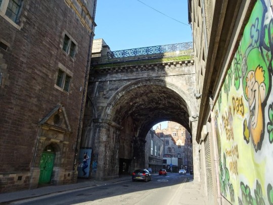
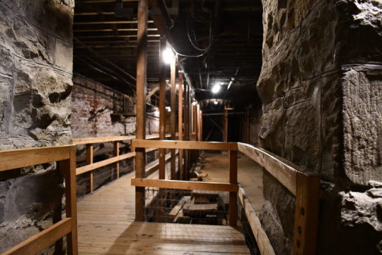
Either you need to level out the terrain by leveling down the peaks and using the dirt to fill in the valleys, or you need to build a lot of streets and buildings on sharp inclines and (if necessary) build lots of stairs (like San Francisco), and/or elevated streets and viaducts (like Edinburgh…or Yharnum), with tunnels to connect areas of lower elevation separated by areas of higher elevation (like Seattle).

Or do a mix.
#asoiaf#asoiaf meta#medieval cities#city planning#urban geography#urban studies#urbanization#history#historical analysis#civil engineering
38 notes
·
View notes
Text
i remember when i was first studying roman britain our teacher would ask us to point to, idk, Verulamium on a map. and nobody could do it. "come on guys!! it's st albans!" nobody could point to that either so it didn't help
SO she got some maps of britain and taught us where stuff was and tested us on our ability to draw roman towns onto a blank map and gradually we improved at it
but specifically we learned to put the roman towns on the map. so sometimes i'll still be blanking until someone gives me the roman name and then i'm like. oh yeah i know where venta silurum is. why didn't you just say that
#although it's been ten years so I'm not sure i can still reliably draw them on#anyway this is the only kind of geography i ever learned. historic geography#and only bc our teacher realised we had never been any of these places and didn't know where they were lol
28 notes
·
View notes
Text
BREAK THE Silence
Where I saw violence in Hebron?
Rank: Lieutenant
Unit: Nahal, 932nd Battalion
Area: Hebron
period: 2014
[ Settlements ]
You’re asking me where I saw violence in Hebron? That’s like asking where I saw Hebron in Hebron. It’s really at every corner. You just leave your post and you’re already on the street that separates people according to their ethnicity or nationality, or whatever whitewashed language is used to justify what’s going on there. There aren’t a lot of places in the [occupied] territories that I think it’s OK for them to be called apartheid, because I think it’s simplifying and one-dimensional, because the situation in the territories is really complex. But in Hebron it’s… I don’t know, I call it "apartheid light." It’s not that I walk around with dogs and hit old ladies all day and do what I please, but it’s very clear where Jews can pass, where Arabs cannot pass. It’s very clear who the army is working for, and it’s not for the Palestinian population. The mission there is not to maintain order; the mission there is to enforce Jewish supremacy in the city of Hebron. It’s not that we soldiers are between a hammer and an anvil, [but rather] we are the hammer being hurled at the Palestinians by the settlers
#i think i get it now#historic fashion#living in america#naruto?#naruto fic#memes image#naruto fandom#naruto manga#vanilla extract#hogwarts legacy#naruto anime#pro feminism#don’t forget about the camps in china not to take away from your post i’m just saying everyone seems to like genocide these days#french#fresh memes#free palestine#fuckin hell#free gaza#cnc free use#free use slvt#free use kink#free congo#free crochet pattern#free sudan#coming from someone who is terrible at geography#free yemen
5 notes
·
View notes
Photo

Source
34 notes
·
View notes
Text
Random questions Google can't help me with:
(even if you don't know, reblog could help a LOT in getting to "the person who knows". So thank you 😊)
1. Islam - How likely it is that Jason use the Hijra (hijaric?) Calander during his time with the LoA🤔
2. Geo-history: spoken languages in Western Asia around 1,300-1,500? Doesn't have to be spesific by years, just sort of. I try to get the possible location, language, religious and calander for some things.
3. what language do the All-caste speak?
Current thoughts:
LoA!
Probably somewhere in the Zagros Mountains? Maybe in the Iranian part. They do speak Arabic, but also Urdo, parasian and pashto. The main Dialect is Arabic, bc it's Ras Al-Ghul og language and that's how he taught his students.
(Also - mybe related to religious? Muslim probably (DoB ~1,300). And iirc being able to read the Qur'an properly has important meaning? I AM NOT MUSLIM PLZ CORRECT ME).
It has a lot of hiding places, wondering tribes, and places to grow food. Going to missions can hide as wonderers.
All-caste!
In the Himalayas, but "Himalayas" is f* HUGE.
WHERE??? Bhutan? China? India? Nepal? Pakistan?
#batman#jason todd#history#geography#geo-history#maps#historic maps#linguistics#all caste#all blades#help#questions#arab#asia#hijra#calander#LoA#league of assassins#league of shadows#ra's al ghul#pakistan#india#himalayas
36 notes
·
View notes
Text

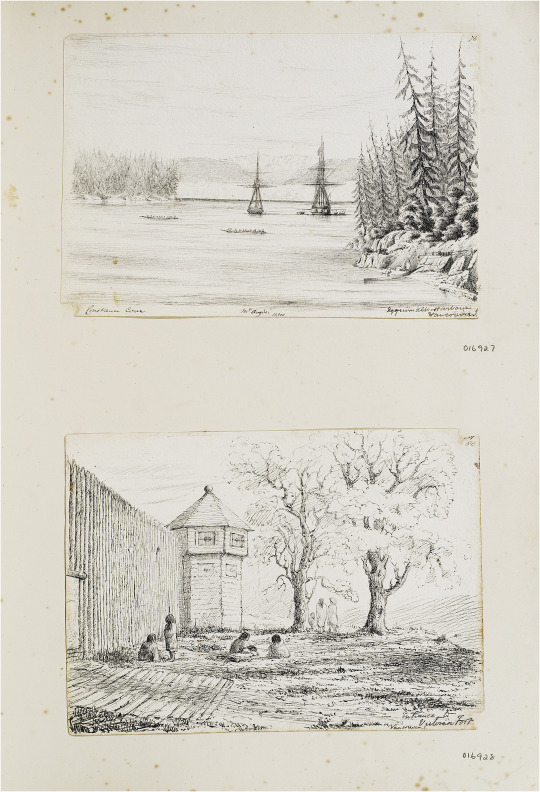


John Linton Palmer, Views near Fort Victoria, June–July 1851, pen and ink, From Chile to the Arctic Album, F030/4 © RGS-IBG.
First plate, top: Esquimalt harbour, with Constance Cove, and Mt Angeles in the distance.
First plate, below: ‘Entrance to Victoria Fort’.
Second plate, above: ‘Fort Victoria, Vancouver I.’.
Second plate, below: ‘From landing place at Victoria Fort’ [original caption].
Third plate: Sketches of people and artefacts, Vancouver Island, June–July 1851.
Fourth plate: Tomb of King Freezy’s brother at the entrance of Victoria Inlet, B. Columbia, 1851′.
"In considering such archival images as traces of encounter, contemporary historians would of course seek to adduce more evidence about the meanings of such events for the participants, in this case both British and Hawaiian, situating these events in their time and place. From this perspective, the rituals of diplomacy, the expectations of the various parties, the knowing and unknowing ways in which these events were described, would all need to be investigated. The same is true of the many other examples of the art of encounter in Linton Palmer’s albums. From an art historical perspective, such imagery would also need to be carefully contextualized with reference to matters of style, genre and perspective. In many cases, as I have argued, the influence of the naval tradition of maritime view-making is clear. However, there is another way of seeing these visual archives, especially when encountered from a heritage perspective, in which the informational content – the documentary detail – may matter even more than the point of view.
In order to substantiate this final point, we should return to Linton Palmer’s Fort Victoria sketches. Fleeting views they may have been, but in their attention to detail – whether the rendering of the hair and adornments of the people he encountered, or the material evidence of Indigenous presence in the landscape – such pencil sketches by naval visitors sometimes record what other contemporary documents do not, and in ways that can be located precisely in space and time. The matt lodges around the Fort, the cedar plank houses across the harbour, a fishing station in the distance: all these features signal an active Indigenous presence at a particular moment preceding a disastrous era in the history of the Indigenous people of what became British Columbia. Since they were first made available to First Nations historians following their exhibition in a 2009 RGS-IBG exhibition (Hidden Histories of Exploration), Linton Palmer’s images have entered the visual archive of Indigenous history and made more widely available in digital form. In particular, they have been incorporated into understandings of local settlement history by Grant Keddie, a curator at the Royal British Columbia Museum in Victoria. As Keddie’s work indicates, there is an ‘archaeological’ way of reading such documents, cross-referencing with other sources of evidence about the precise geography and chronology of landscape change. As is clear from the contemporary significance of the Indigenous sites sketched by Linton Palmer, such work is far from merely of academic interest. In 2001, 150 years after the brief visit of HMS Portland to Fort Victoria, a claim was filed in Canadian courts asserting that the land on which the Parliament of British Columbia was built (near the original Fort) had originally been occupied by or promised to First Nations peoples. After a long and contested legal process, the Ministry of Aboriginal Affairs and Reconciliation eventually reached an out of court settlement with the representatives of the Esquimalt and Songhees nations, which has been valued at $31.5 million dollars. In this context, mapping the precise geography of Indigenous settlement in space and time mattered a great deal: in fact it truly was the multi-million dollar question. And in the process, as researchers and consultants pored over long forgotten maps and drawings not unlike Linton Palmer’s sketches, the visual archive of travel acquired a new value."
- Felix Driver, "Material memories of travel: the albums of a Victorian naval surgeon." Journal of Historical Geography 69 (2020): 53-54
#linton palmer#historical geography#art album#royal navy#vancouver island#victoria#settler colonialism in canada#settler colonialism#indigenous land claims#indigenous history#british empire#canadian history#academic quote#first nations#indigenous people#british columbia history
6 notes
·
View notes
Text
Geography in 1500, England-Part 1-basics
I myself was wondering how all the land under English Crown was divided in Tudor times. Except from 1510 sumptuary law gives a clue:
“That no one who does not possess the title of a lord, and who is not a Knight of the Garter, may wear any woolen cloth manufactured outside of England, -Ireland, Wales, Calais or Berwick, "or the marches of the same."
Hence according to Tudors English Crown consisted of England, Ireland, Wales, Calais, Berwick + the marches(which were within England).
Not Marshes as this:
But as border areas. There were two marshes-Welsh Marsh, next to Wales. Ludlow was located in Welsh Marsh-hence technically still within England, and then there was Scottish Marsh in the North.
Ireland had lots of indenpendent territories which didn’t aknowledge Tudor rule at all, and then English Pale, but I’ll do separate post about Ireland itself and explain more in detail there.
Wales was once idenpendent but even before War of Roses fully under the control of English.
Calais is city nowadays in France, but it was English right until reign of Mary I. It was english enclave and important trade connection between island England and continent.
By the way, it wasn’t formerly part of Normandy, it’s bit more up North from that...and was actually captured by English in 1347 and stayed English until 1558, when Mary I lost it to France.
You probably knew all of that. But what the hell is Berwick?!
Well, actually there are several towns called Berwick.
I believe the record is talking about Berwick-upon-Tweed(or on the Tweed).
(Historically it was called by Scottish as South Berwick, because they also had another town called Berwick more North, which they called North Berwick).
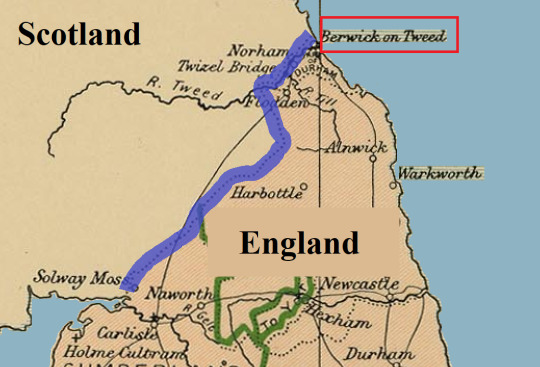
A town on Scottish/English border, over which they fought many times and it changed many hands. But it seems the town had different status than any other town, and in 1551 Berwick was declared to be free town, indipended from either Kingdom. In practise controled by English, but had independed borough, outside of authority of any English county. The wording of sumptuary law in 1510 suggest Berwick had similiar status even long befor this.
(Maybe just not officially.)
It was sort of enclave, like Calais, with special rules.
Interestingly the town was offered by Margaret of Anjou to Scottish in 1461(for their support) and before Richard III proclaimed himself king, in 1482 he recaptured the town from Scottish. Scottish didn’t accept this conquest, in their documents it was still Scottish many years later, but in practise the town remained English ever since. Elizabeth I spent massive funds for fortification of the town. So clearly it was very important.
Until Scottish and English crown united in 1603.
And then there are/were islands. And quite often it is mentioned in records(or on wikipedia) that somebody (nobles) in times of distress(like political situation being unstable) would seeking shelter/refuge upon these islands...
If the island was separated only by narrow strait from mainland, it was much easier to govern, and was offically part of the mainland territory.
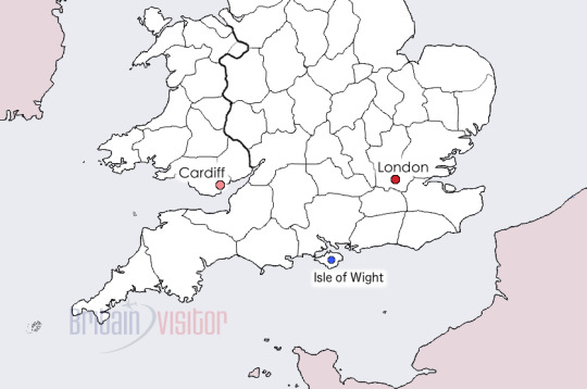
For example to the South of Englad we have Isle of Portland(source of Portland marble) and Isle of Wight. They were part of Kingdom of England.
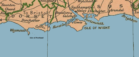
Isle of Wight again:
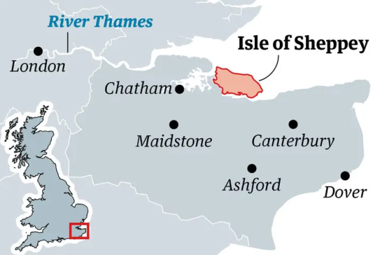
To west of London is Isle of Sheppey:
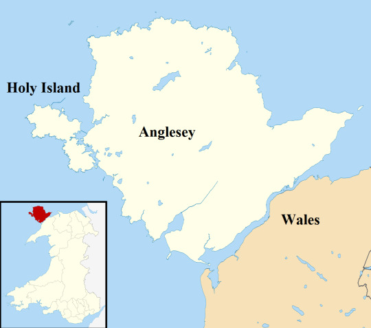
And to N-W of Wales is Anglesey and Holy Isle-which were part of Wales:
But what if Island is further away?
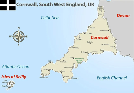
To West of Cornwall(S-W England) are Isles of Scilly:
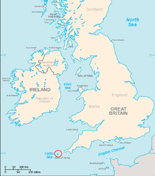
Also called Sorlingas (Spanish, Portuguese) or Sorlingues (French). In the Cornish language, the Isles of Scilly is Syllan.
They are further away, but still under control of English since before 1000, and were part of England.
However, there are islands, which never became part of English Kingdom(nor Wales) but were under English Crown. For centuries.
Nowadays they are the dependencies of the British Crown(not to be confused with overseas crown depencies) They are still under same monarch, but have their own goverment, passport etc.
Some of them now claim they had special status since medieval times, it is not confirmed as far as I know.
But due to them being further from England, it is likely they had some level of automy and special governing from before Tudor era. Even if it wasn’t offical. They are simply not close enough to any mainland coast for it to be easy to control them. But probably because it wasn’t official that Sumptuary law didn’t mention them. (It could be just traditional...)
-Isle of Man, which is located in Irish Sea between Ireland, Scotland, Wales and England:
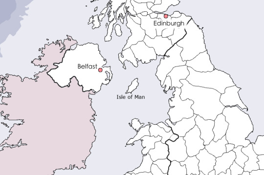
In past it was conquered by vikings, and in 13th century Scottish King bought it from Norway in 1266, but in 1290 English seized it. In 1313 Scottish retook it, and then for rest of 14th century it kept changing hands. But by beginning of 15th century it was in English hands and would be ruled by Stanleys.
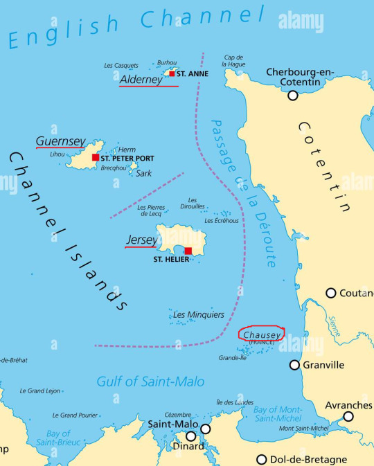
-and the bigger of the Channel Islands(not to be confused with Californian Channel Islands).
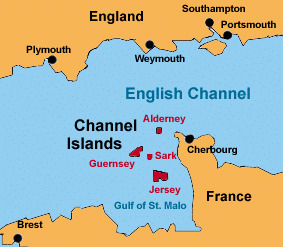
I am talking about islands in English Channel(La Manche, sometimes they are refered to as Norman Islands, and that is pretty accurate.
The channel islands originally belonged to Duchy of Normandy and when English lost the mainsland Normandy and they managed to keep those islands.
-Biggest islands being Guerseney, and Jersey and then smaller Alderney, and many smaller islands:
But that is not entire story. Because English kept the bigger ones, which are now considered Channel Islands, but during Tudor times, English abandoned the smaller Chausey islands and eventually French took hold of them.
On wiki you can find that Chausey Islands were administered from Jersey until 1499, when the Jerseymen abandoned it to the French for reasons unknown. The Jersey historian Alec Podger has suggested that it was too costly in terms of money and manpowower.
Addionally I am truly confused in how Channel Islands are described nowadays. Because I literally never came upon word bailiwick before.
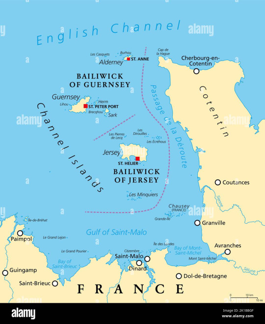
There is Bailiwick of Jersey and Bailiwick of Guernsey. That’s their official name. But what is it? Well, I read the definition several times and I am no wiser.
Best I understand it(and I might be completely wrong) it is Administrative term originating in french language, which sort of groups those islands together under the name of the biggest island. Sort of like town of Buckingham gives name to Buckinghamshire, but with islands.
If somebody understands it better, I am all ears.
Another thing you should know, that English coast nowadays and back then is not same. From Arthurian legends you probably know erosion occured on big scales even back then! (One of Arthur’s knights was prince of Kingdom West of Cornwall which sank under sea.)
But strangely the coast also can grow bigger.
WHAT?! What the heck you mean?’ -you asked.
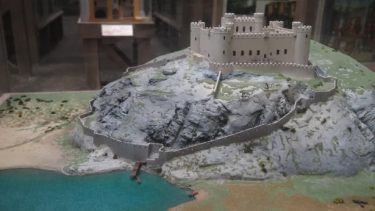
Allow me to demonstrate-this is reconstruction of Harlech castle(in Wales)-how it used to look:
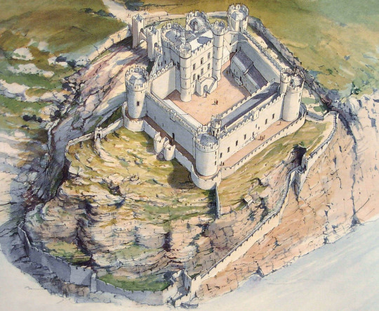
In botton of the picture you can see it had access to the sea, and it could be supplied by ship. Maybe this is better:
And this is current view from Harlech castle from google maps:
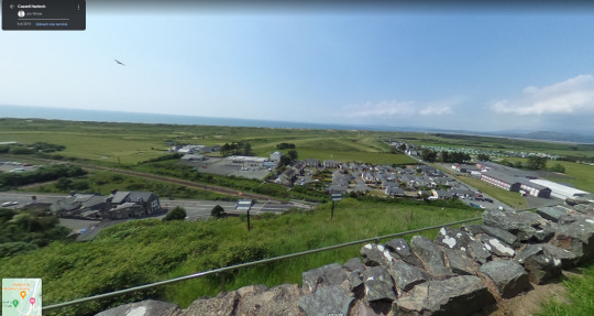
The sea is several km away and there are many buildings in places where once the sea was. Overtime sediments build up in the place, and coast grew!
It’s not the case that west coast grows and East disappears, it’s more complicated than that...But important is, the coast is changing and if you ever time-travelled, be aware.
So I hope you’ve learned something new from this.
5 notes
·
View notes
Text

Train wreck at Montparnasse on 22nd October 1895.
Train crash at Gare Montparnasse in Paris in 1895. The train fell through the window onto the street! A train approached the Gare Montparnasse station on October 22, 1895 in Paris. Express No. 56 Granville - Paris, with 131 passengers. The brakes on the locomotive were faulty.
At four o'clock the locomotive broke the station's stopping shoes and crossed the terrace, smashing the front wall of the station and then falling onto a tram stop located 10 m below the station.
#steam train#paris#montparnasse#crash#vintage photography#artwork#historical#print#station#railway#conductor#insurance#passengers#injuries#fawlty brakes#accident#spectacular#gare montparnasse#aftermath#geography#france#train station
3 notes
·
View notes
Text
the fact that the us government can continue funding and arming a genocide despite massive public opposition really highlights how inherently non-democratic the united states is
#almost like the idea of a representative demcracy is both historically undemocratic and inherently is incapable of being so#by historically i mean that representative democracies have always meant the creation of a category of ‘citizen’ that is above ‘non-citizen#even the civilization where the term democracy comes from was patriarchal and had fucking slavery#not chattel slavery but (hot take) non chattel slavery is still bad.#also fundamentally one person can literally not represent the wishes of a large collection of people who have only geography in common.#theyre going to want different things!!!#now the idea of if democracy is inherently a virtue is like. another topic. but i will say that like seeing the history of like the#popular sovreignty movement wrt to slavery really made me question it. just because a lot of people want something to happen doesnt#actually mean it should happen. white people voted to legalize slavery#kind of where the old ‘minority’ terminology comes in. just by numbers alone in the states that had these votes it wasnt like in the south#where in the south because of plantations the actual population majority in some places was black.#but in those midwestern new states even if everyone person there could have voted. white people would still be the vasy majority.#honestly to a degree pointing out that none of the societies that have claimed to be democracies have truly been democratic is…#i guess the primary value in it is to challenge people who take state mythologies at face level#a very large population that i often forget exists.#the ‘they cant do that its illegal’ types.#anyways. if we consider that every society in documented history has had some type of violence and oppression#and if we believe that people are NOT inherently selfish/violent#it follows that what we need to do is something different than what we have been doing.#not just different from what we are doing right now. but different from what we have been doing for the past centuries#but also i can imagine that societies and ways of living that aren’t legible to the status quo or just went undocumented for other reasons#may have been more egalitarian. and we dont know due to erasure (either intentional or non-intentional)#both erasure and a fundamental inability of historians to comprehend it. similar to how cishet historians who cant fathom the idea of#transness or lesbianism talk about things.
6 notes
·
View notes
Text
just because you’re american and didn’t have like geography class or whatever doesn’t mean you’re incapable of ever looking at a world map i’m constantly baffled by americans who say that it’s bc of our school system that they don’t know where other countries are. like.
#i did have geography as an elective but also#i had lots of history teachers with world maps on their walls#and like. being an adult not knowing where major countries or continents are is.. embarrassing#have a minute understanding of the world around you i’m begging#idk i saw like 3 posts in a row abt americans saying they don’t know things bc of school#what fuckin schools are you going to also??#i went to low funded urban public schools my whole life and i still got taught things#i saw maps of the world and learned basic historical info#i think it’s fine if you just didn’t pay attention but i really doubt your american schools were that bad
11 notes
·
View notes
Text
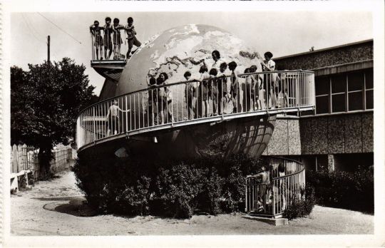
Geography lesson in the "Outdoor School" of Suresnes, western suburbs of Paris
French vintage postcard
#outdoor school#vintage#outdoor#tarjeta#briefkaart#lesson#postcard#geography#photography#postal#school#the of#carte postale#sepia#ephemera#historic#paris#french#ansichtskarte#postkarte#suburbs#western#suresnes#postkaart#photo
2 notes
·
View notes
Last Seen Blogs

t3sknota
Będę zawsze blisko ciebie..

romantic-roses
Romantic Roses

nic0llette
find your wild.

kakoband
KAKO BAND
georgianadesign
Georgiana Design