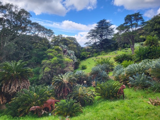
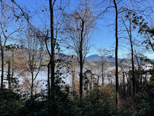
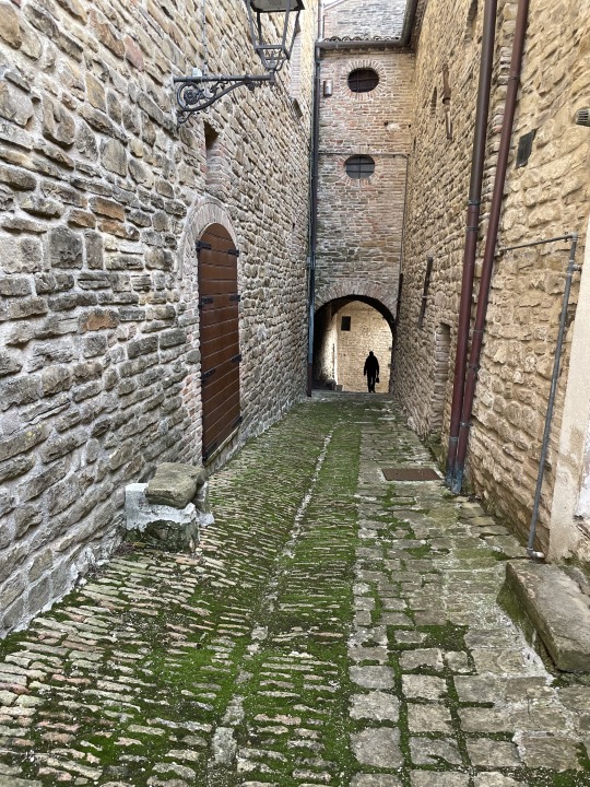
#3 are from the north/Misty mountains
Photo
Legends and myths about trees
Forest spirits and natives (2)
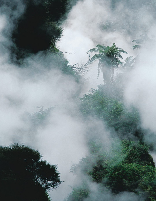
Patupaiarehe – Night spirits of the Maori people of New Zealand. Dwell in the darkness deep in the forest.
Patupaiarehe are legendary humanoid cryptids native to New Zealand that hide in forests and are said to have the power to induce a trance and to lure people away. They are supernatural beings (he iwi atua) in Māori mythology that are described as pale to fair skinned with blonde hair or red hair, usually having the same stature as ordinary people, and never tattooed.
They can draw mist to themselves, but tend to be nocturnal or active on misty or foggy days as direct sunlight can be fatal to them. They prefer raw food and have an aversion to steam and fire.
The music of their kōauau and pūtōrino (small flutes), along with their singing of waiata, which songs are sung solo, in unison, or at the octave, occasionally reveals their presence on foggy days. A kōauau is a small flute, ductless and notchless, four to eight inches (ten to twenty centimetres) long, open at both ends and having from three to six fingerholes placed along the pipe.
They could lure people away from safety with the music of their flutes, and had magical powers and special knowledge. Some believe that red-haired Māori are their descendants. Patupaiarehe sometimes taught people magical chants and other skills. They were good at fishing, and one chief spied on them to learn how to make nets.
Patupaiarehe were seldom seen. They were thought to live in several places in the North Island, including in the Waikato, around Rotorua and in the Urewera mountains. They also lived in some places in the South Island.
kōauau sound demonstrations

木にまつわる伝説・神話
森の精霊たちと原住民 (2)
パトゥパイアレヘ 〜 森の奥の暗闇に棲んでいるニュージーランドのマオリ族に伝わる夜の精霊
パトゥパイアレヘは、ニュージーランドに生息する人型の生物で、森に潜み、トランス状態を引き起こし、人を誘い出す力があると言われている。彼らは、マオリ神話に登場する超自然的な存在 (ヘ・イウィ・アトゥア) で、青白い美肌、金髪または赤毛、通常普通の人と同じ背丈で、タトゥーをしていることは無いとされる。
霧を引き寄せることができるが、直射日光が当たると命に関わるため、夜行性で、霧や霧のかかった日に活動する傾向がある。生ものを好み、蒸気や火を嫌う。
コワウアウとプートゥリーノ (小笛) の音楽と、ソロ、ユニゾン、オクターブで歌われるワイアタの歌は、霧の日に時々彼らの存在を明らかにすることができる。コアウアウは、長さ4~8インチ(10~20センチ)、両端が開き、パイプに沿って3~6個の指穴がある、ダクトもノッチもない小さな笛である。
彼らは笛の音で人々を安全な場所に誘い出し、不思議な力と特別な知識を持っていた。赤毛のマオリ族はその末裔であるという説もある。パトゥパイアレヘは時々、魔法の呪文やその他の技術を人々に教えた。彼らは漁が得意で、ある酋長は網の作り方を学ぶために彼らを見張った。
パトゥパイアレヘはめったに目撃されることはなかった。ワイカトを含む、北島、ロトルア周辺、ウレウェラ山脈など、いくつかの場所に生息していたと考えられている。また、南島のいくつかの場所にも住んでいたようだ。
コアウアウ・サウンド・デモンストレーション
#trees#tree legend#tree myth#mountain tribes#patupaiarehe#might spirits#maori#kōauau#pūtōrino#sound of nature#new zealand#nature#art
134 notes
·
View notes
Text
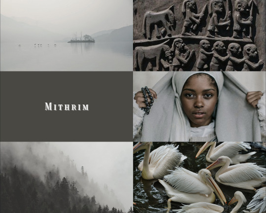

peoples of middle-earth ❖ the mithrim
"Now in Mithrim there dwelt Grey-elves, folk of Beleriand that had wandered north over the mountains, and the Noldor met them with gladness, as kinsfolk long sundered..."
- J.R.R. Tolkien, The Silmarillion, "Of Beleriand and its Realms"
[ID: a picspam comprised of 12 images in shades of dark and light grey.
1: A misty lake surrounded by mountains, containing a single island from which some birds are flying / 2: A carved igbo door depicting people and animals / 3: White text reading "mithrim" in all caps on a dark brownish-grey background / 4: A black model wearing a grey headscarf that they hold out to either side of their head / 5: Forested mountains in the mist / 6: Several white pelicans in dark water / 7: Traditional igbo cloth decorated with white designs, including a drawing of a cat-like animal / 8: A lake amid mountains or large hills / 9: Three black models standing together, all wearing grey shirts. Two of them have braided hair and they all are looking at the viewer / 10: Same format as Image 3, but the text is all lowercase and reads "grey-elves" / 11: Fishing nets / 12: Trees seen across water through fog /End ID]
#edits with the wild hunt#brought to you by me#the professor's world#elves elves elves#mithrim#the silmarillion#mepoc#picspam#tolkienedit#elvensource#tolkiensource#silmedit#oneringnet#described
37 notes
·
View notes
Text
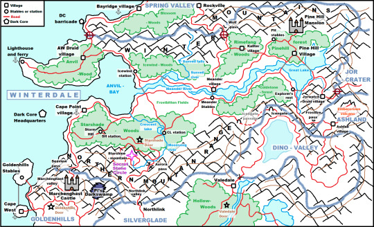
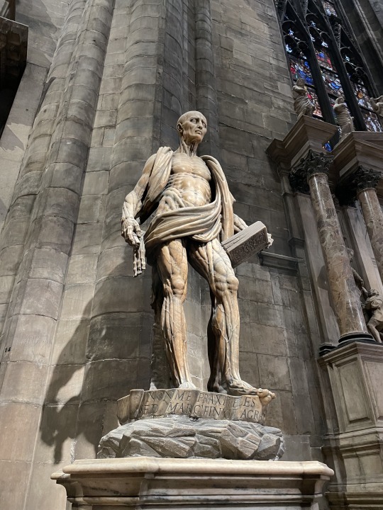
WINTERDALE (full unofficial map)
Points of access:
1. Through GOLDENHILLS:
Marchenghast Castle- the road to the castle/estate blocked by rocks is now cleared, you gain access to the Marchenghast castle and valley. Ride through it to get to the scenic Seaview pass. The Seaside road leads to Cape point village.
2. Through SILVERGLADE:
Northlink- tunnel cleared. Ride through the forested (redwoods) Northlink valley and the Aurora pass. Road leads to an abandoned ranger station in the Northern Mountain Range. From there, the eastern road leads to the Secret Stone Circle, the western one descends down the mountain through the Starshade Woods.
3. Through DINO VALLEY:
Icengate- the kallters opened the gate. You ride through a fully subterranean tunnel of ice and stone, design similar to Stonecutter’s Vault: the Icengate passage. The other side opens in the Coldstone forest, road leads to Meander.
4. Through ASHLAND:
Frostfire pass- ride to Ashland, then to Ashfall village. The western path leads to the Embercrown volcano, the eastern one to Frostfire pass. Ride through the gorge of fire and ice, and you get to Explorer’s rest, a Jorvik rangers outpost.
NEW FACTIONS:
--Pine Hill: PH mansion, PH village, PH stables.
--Kallters: Rimefang woods, Winter mountains.
--Winderdale druids: Anvil wood, Jorwatch, all over the valley
--Winterdale rangers: Icewind-woods, Starshade-woods, Coldstone-forest
--Meander: village and stables, Frostbitten fields
--Cape Point: fishing village
LOCATIONS:
1. Pine Hill Area: village, stables and mansion. Pine forest, safe to ride in. Mr Sands resides in the mansion after leaving Garnok’s side. Showjumping and trail riding in the area.
2. Kallter Area: the Rimefang woods is infested with wolves. Frosted mammoth pine trees, fallen trunks, misty woods. If you go too close to a wolf , it will start to chase you and you need to gallop to lose it. If it catches you, you are teleported out of the woods with the message: “Your horse got you out, but be careful, next time you might not be this lucky!” Hidden kallter village in the middle.
3. Icewind Area: Winterdale rangers’ Icewind station. Trailrides in the forest. The Sunveil falls is a high waterfall coming from the Winter mountains.
4. Anvil Wood Area: mild seaside forest, Winterdale Druid village in the middle. A lighthouse and a ferry point at the end of the peninsula.
5. Cape Point Area: fishing quests, ferry. The Starshade woods was called Nightmare woods and was infested with the forces of the darkness before you cleansed it. Two ranger stations in there, one on the Stormhill and the other next to Crescent lake. A secret, winding path leads up to Starshine mountain to the Secret Stone Circle. The fifth door/beacon is in the forest.
6. Meander Area: village and stables. There are races in the Frostbitten fields and some going up the Northern Mountain Range also. South road leads to the Icengate passage.
7. Coldstone Area: the forest has trailrides. It is rockier, the trees more scarce, you can regularly find blue crystal clusters. Explorer’s rest is a ranger station. From there, the road to the south leads to Frostfire-pass, the road through the bridge leads to the eastern side of the Great Lake and to Jorwatch Druid Village in a hidden valley.
Stop signs:
1. North of Anvil Wood: iron gate. Road runs next to the abandoned DC barricade to Bayridge village. The gate has been closed since the Winterdale storm hit.
2. Wolf-pass: in the Rimefang wood, going through the Winter mountains. Direwolf packs roam the mountains, the pass is closed off as it is too dangerous to go through it.
3. Jorwatch road: the path leading to the Jorcrater is covered in thorns and vegetation, fallen trees and rocks. The druids keep it that way, since the Jorcrater is too dangerous to enter.
#sso#star stable#star stable online#starstableonline#winterdale#sso winterdale#sso headcanon#sso map#star stable winter rider#sso kallters#sso pine hill
70 notes
·
View notes
Text
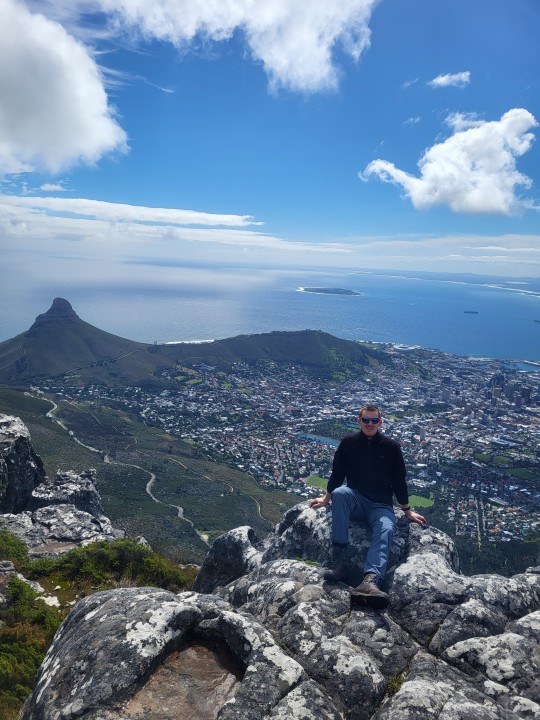
The countdown to our departure from the swamp to the freezer of the world has started. Last week was my last week of work, and Naomi likes to now tease me saying I'm partially retired... So what do retired people do? Travel. When we were deciding where to go for our last trip on this side of the globe, we initially had planned for it to be in Europe. But after checking flight tickets and times, South Africa seemed like the place to go. Maybe the many friends that have recommended it also played a small role.
We arrived in SA on Thursday eve where we picked up our rental car and drove to our guesthouse.
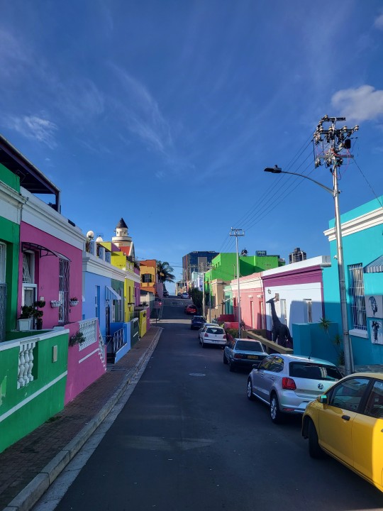
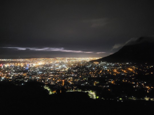
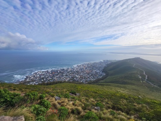
Day 1 we hiked up Table Mountain via the Platteklip Gorge. Upon reaching the table we first hiked to the smallest and flattest peak I have ever seen. From there on we hiked along the ridge, which presented some stunning views of the city below to the cable cart that took us back down. After our hike we drove into town to visit a neighbourhood called Bo Kaap, where many of the houses are bright and colourful. This represents the event when slaves were allowed to buy their own houses and did not have to rent the standardized white houses they lived in before. When getting out of our car a guy approached us and told us he was our "parking attendant" for which a small donation was welcome. Being the poster boy tourist, tall, blond and white he must've seen his chance for which he was greatly rewarded. Because we didn't have any small change on us, he suggested going to the shop across the road to buy him some food. This turned out to be a months worth of peanut butter and oil totalling 8 euros, for what would end up to be a 30 minute parking session. Amsterdam parking tariff isn't that bad after all. Note to self, always carry small change for tipping. At least when we got back to our car the windows had not been smashed, tires not deflated and we could spread the Dutch love for peanut butter.
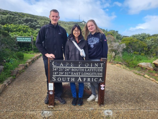
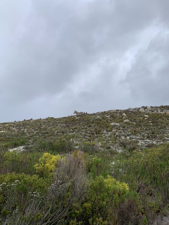
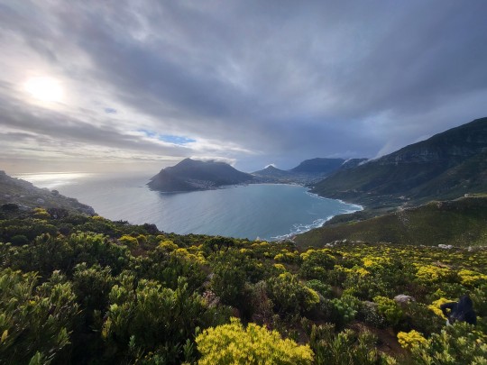
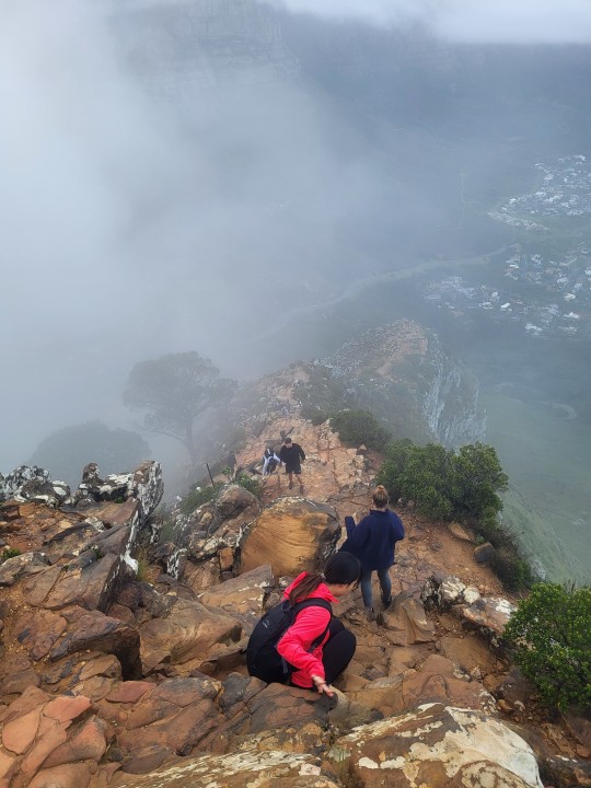
Day 2 was rainy and misty, so we decided to do our drive around Cape Peninsula that day. First stop was visiting a penguin colony, where we applied our learnings from the day before and tipped the parking attendant the appropriate amount. We continued our journey to Cape of Good Hope, where the rain stopped... and it started to pour. Unfortunately, visibility wasn't great, and the name "good hope" turned out to be false advertising as it only got worse. When leaving the park we ran into a wild zebra, which caught us all by surprise. Didn't zebras only live on the savanna far away from civilization? I was definitely not expecting to see one out here, but a comforting surprise to a day where the pouring had turned into hosing from the sky. On with the drive, we stopped at a local coffee shop in Scarborough where we ate the most delicious sweet potato wedges ever. That fries shop in Sydney Australia has been beaten and we proceeded on our coastal drive up north again. Halfway along we stopped for a hike up Chapmans Peak. Unsurprisingly, the peak was also covered in clouds, so we did half the hike and waited for the bay to clear up while hiding under a bush. Once it cleared up, the view was lovely.
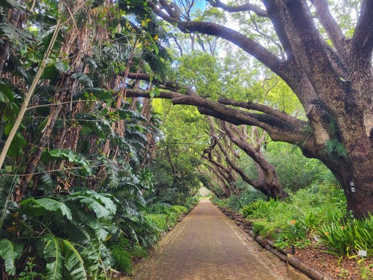
On day 3 we got up at 5am to hike up Lion's Head to see the sunrise over Cape Town. Halfway up the view was clear and the city beautifully lit by all its lights. At the top the clouds rolled in again preventing us from a clear view of the city, but the sunrise was pretty nevertheless. We headed to the botanical gardens where we saw the most special plants so far only seen on National Geographics. We had lunch at the local foodmarket where I had a 500 gram serving of beef ribs from the braai. Lekker! In the eve we made good use of Brandon and Michaela's, our SA friends, Spurs giftcard to endulge ourself over a hearty meal. For me this time a 500 gram T-bone steak. Equally delightful was that we got to watch Arsenal beat Man Utd. 3-1 to send the reds to the right side of the table.
Coming up will be our 5 day roadtrip over the Garden Route, followed by 5 days in Kruger nation park where we DO expect to see zebras. Not too busy packing for our move yet. That will come after this trip.
9 notes
·
View notes
Text
Savachi is from the Kingdom of Eldoria, a fictitious medieval realm nestled between misty mountains and rolling green hills. Eldoria is ruled by King Aleathic III, a fair and just monarch known for his wisdom and benevolence. The capital city, Arindale, is a bustling hub of trade and culture, with its towering castle overlooking the cobblestone streets below.
Surrounding Arindale are lush forests teeming with mystical creatures and hidden ruins from ancient civilizations. To the north lies the Frostpeak Mountains, home to fierce yet noble clans of dwarves who mine precious gems and metals coveted throughout the kingdom.
In the heart of Eldoria, the River of Serenity flows, providing fertile land for farming and sustenance for the kingdom's people. Along its banks, picturesque villages dot the landscape, each with its own unique traditions and folklore.
Eldoria is also known for its chivalrous knights, who uphold honor and defend the realm from threats both within and beyond its borders. The Order of the Silver Lion, led by the valiant Sir Tristan, is renowned for its bravery and unwavering loyalty to the crown.
But amidst the beauty and grandeur of Eldoria, dark forces stir in the shadows. Rumors speak of ancient curses and forgotten evils awakening once more, threatening to plunge the kingdom into chaos. Only time will tell if King Aleathic and his loyal subjects can stand united against the encroaching darkness and preserve the peace of Eldoria for generations to come.
This is very well thought out because most of the book is going to be set in Eldoria (I'm planning on making 3 books) :D
1 note
·
View note
Text
If anyone's wondering about my categorization for LotRO's fish regions:
Region 1: Bree-land, the Shire, & Ered Luin. Your cookable fish here are Catfish and Dace. There are no deed fish to be caught here.
Region 2*: The Lone-lands & the North Downs. The cookable fish here are Catfish, (presumably) Dace, Perch, and Trout. The deed fish available in this region are Trout and Salmon.
Region 3: The Trollshaws & Evendim. The cookable fish here are Golden Mullets, Perch, and Trout. The deed fish here are Trout and Salmon.
Region 4: The Misty Mountains, Angmar, & Forochel. The cookable fish here are Carp, Flounder, Golden Mullets, and Largemouth Bass. The deed fish are Salmon and Darters.
Region 5: Moria through Gondor & Swanfleet & Cardolan (apparently). The cookable fish here are Carp, Flounder, Golden Mullets, and Largemouth Bass. The deed fish are Salmon and Sturgeon.
Region 6: The Wastes, Gorgoroth, & Minas Morgul. There are no cookable or deed fish here, only non-fish junk.
Region 7: Eryn Lasgalen, Ered Mithrin, & Elderslade. The cookable fish here are Catfish, Dace, and Trout. The deed fish are Trout and Long Lake fish.
Region 8*: The Vales of Anduin and Wells of Langflood. The cookable fish here are (presumably) Catfish, Dace, Carp, Flounder, Golden Mullets, Largemouth Bass, and Trout. The deed fish are Trout, Salmon, Long Lake fish, and Sturgeon.
Region 9*: Gundabad. The cookable fish here are Catfish, Dace, Carp, Flounder, Golden Mullets, & (presumably) Largemouth Bass. The deed fish are Long Lake fish, Darters, and Sturgeon.
*I have limited data for these regions. While I'm confident in their categorization as separate from the other regions, I have not fished enough here to be confident about all the fish to be caught. Fish preceded by (presumably) are assumed to be present based on the other fish in the region. However I have no record of catching them there and may be mistaken.
(Further disclaimer: I am currently investigating this further, but it may not be possible to catch all of these fish in all locations within a region. Specifically, I have experienced a shocking dearth of cookable fish on the Barrow-downs, and am currently experimenting to confirm my suspicion that they cannot be caught at all there. Will update with further information as soon as I have enough data to confidently say one way or another.)
12 notes
·
View notes
Text
Auguri di Buon Anno!

It’s been quite some time since my last post – time seems to be racing away from me.
After my last post, we travelled back up north, this time to Lombardy. After spending a wonderful few days in the Bergamo region, we returned to our little home in Le Marche to prepare for Christmas and for our planned trip south to Puglia. We set off on this latest trip 3 days ago and are currently in Chieti, in Abruzzo. Tomorrow we head off to Trani in Puglia, and then to Lecce. But first things first … here is a post about our time in Lombardy.
A visit to Lombardy
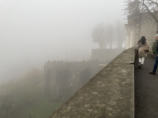
On 15th Dec we headed back up north to San Paolo d’Argon, a small community near Bergamo, in the province of Lombardy, to spend a few days with my cousin and her husband. The day started off well; we programmed the GPS in our French car and it promptly sent us off towards Perugia in Umbria. Being the trusting type, we followed the directions which led us up through the centre of Italy, over the mountains, and towards Bologna. It was a much steeper, harder route than the ‘usual’ one via the autostrade. I swear that the GPS just wanted us to traverse more mountains, this time mountains shrouded in mist and fog. Ahh, the excitement of travelling across some very high bridges over what appeared to be deep ravines – I say ‘appeared to be’ because the fog was too thick for us to see anything beyond the guardrails.
Or maybe the GPS just wanted us to traverse Tuscany, albeit a little bit of eastern Tuscany high up in the Apennines!
Back to San Paolo d’Argon and Bergamo …
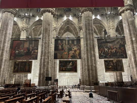
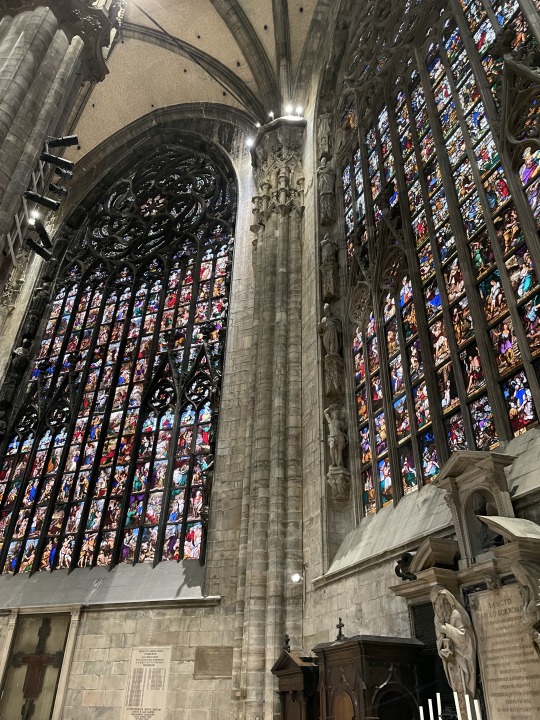
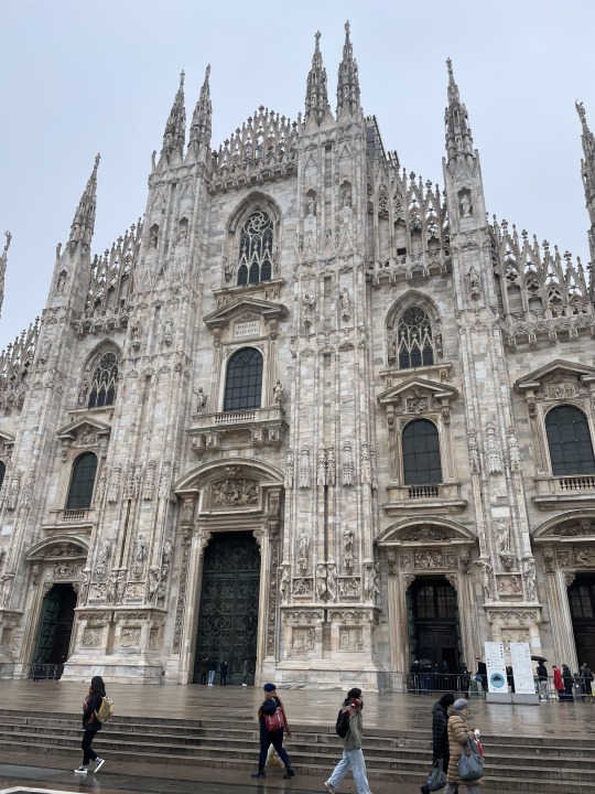
Our stay in San Paolo d’Argon was jam packed with wonderful experiences, amazing food and good times with family and friends. One of the first things we did was travel into Milan to see the famous Duomo, the exterior of which we’d seen on our last trip in Nov 2019; at that time we decided against trying to get into the Duomo as it was cold and wet, the queues were long and we were pretty exhausted and getting ready to return home.
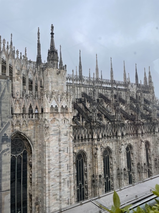
The Duomo is breathtakingly beautiful and very imposing. Its construction began in 1386 and continued for many, many years with the façade only being completed in the early 1800’s. Apparently it is the largest and most elaborate Gothic building in Italy, and the largest Gothic building whose rooftop you can walk on – we skipped this option because of the low visibility due to the fog. But we did have an advantage having visited during winter as the queue to get in was pretty short.


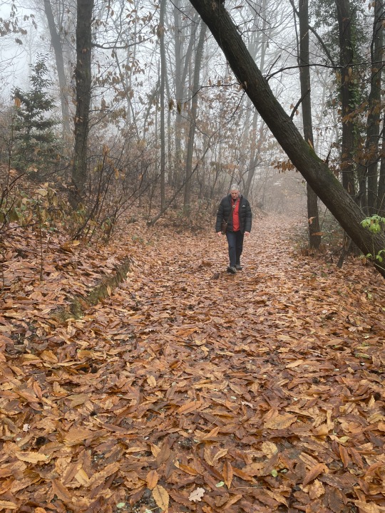
The next morning Allan and I ventured out for a short walk which ended up extending over 6kms around a rather high hill. We walked up high enough to see the sky above the mist – the first and only time we would see blue sky during this trip up north. It was magical walking through the deciduous forest with the ground covered in leaves.

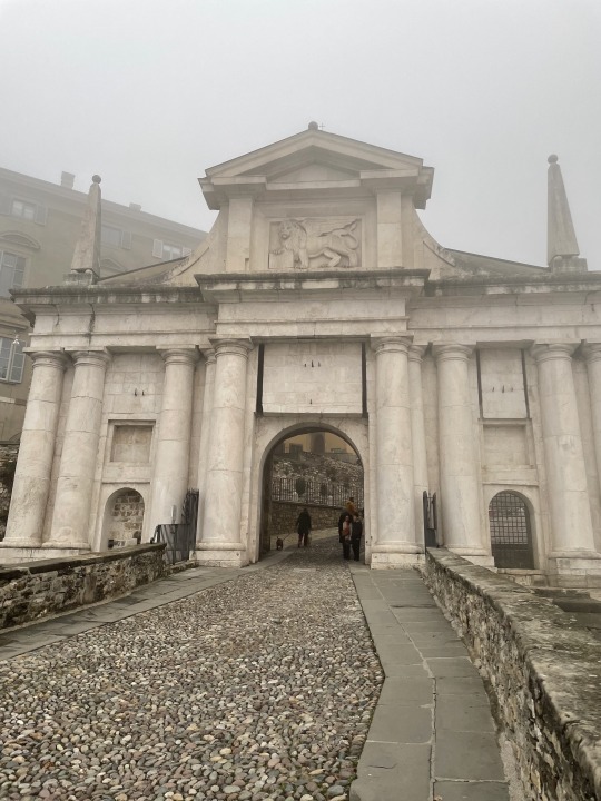
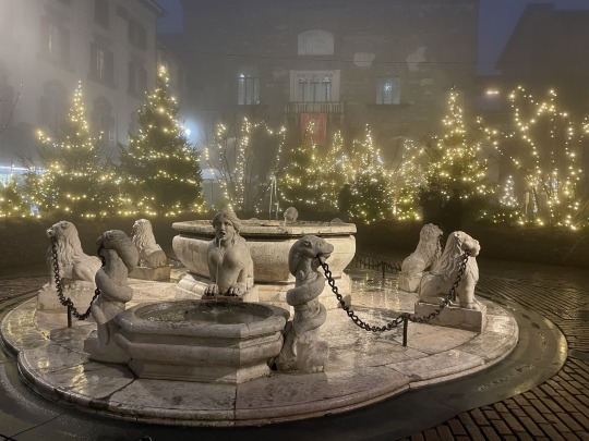
Later on in the day, we ventured in to see the Centro Storico of Bergamo. Again, we encountered misty weather which served to make the visit quite mysterious and fantastical.
Bergamo’s origins are ancient and can be linked back to prehistoric times. A perusal of the information currently available on Google indicates that Bergamo was home to many different tribes and peoples including the Etruscans, the Gauls, the Romans and even Attila’s Huns, the Longobards and the Byzantines.
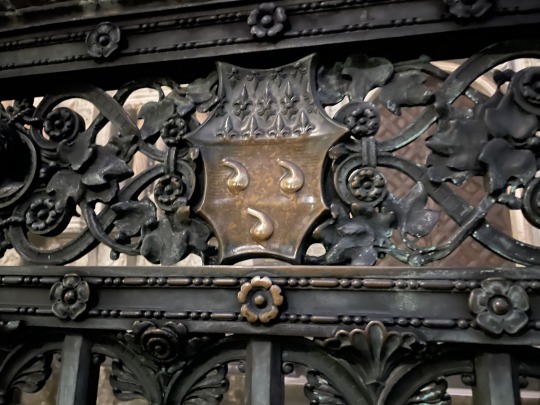
Situated on a hilltop at the foot of the pre-Alps and overlooking the flatlands, Bergamo offered a strategic natural stronghold for its occupants. For a time it was held by the Viscounts of Milan until 1428 when it fell to the Venetians. The Venetians rebuilt the old city and erected imposing defensive walls. They installed Bartolomeo Colleoni, a powerful mercenary and Captain-General of the Republic of Venice and a member of the Colleoni family of Bergamo. Colleoni’s coat of arms which is engraved on the gates to the private family chapel features three ‘balls’ or testicles. It is said that Colleoni suffered from being orchitic and that he did indeed have three testicles, something he was very proud of. Legend has it that rubbing the balls on the gates to the family chapel brings one luck.
Colleoni was reputed to be a vicious and violent ruler (do correct me if I’m wrong). Mind you, he didn’t have to do much to protect Bergamo as it was impossible to get close to the city without being seen. The Milanese didn’t even try to use force to reclaim the city; instead, they offered Colleoni more money than the Venetians to try and gain his support. On his part, Colleoni used each offer from Milan to bargain for even more money from the Venetians who were very willing to pay more in order to retain control of the city. Bergamo was very important for Venice as it overlooked the most accessible passage into northern Europe and controlling the city offered the best protection for this trading route.


San Paolo d’Argon
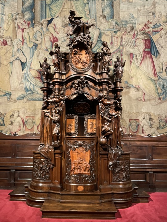
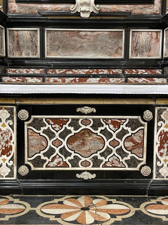
While staying at San Paolo d’Argon, we joined a guided tour of the old Benedictine Monastery which now functions as a school. The monastery was initially founded in the 11th century and reconstructed in the 16thcentury with perfectly proportioned and clean lines. The old refectory features frescos painted by Giovanni Battistia Lorenzetti (painted in 1624). The reconstruction of the adjoining church which continues to function as such, commenced in 1684. The complex survived the suppression of the monastery and confiscation of its assets by Napoleon in 1797. The site is beautiful and certainly worthwhile visiting.


Traveling back to Le Marche
Okay, this time we made sure that the GPS was leading us back to Sassoferrato - Genga via the autostrada – about 90kms shorter and a hell of a lot faster than travelling over the mountains. The autostrade here are very impressive with regular tunnels traversing right through any mountains and hills along the route.
We were getting hungry and tired and so we stopped at Serra San Quirico, a fortified medieval village set on a rocky outcrop on the foothills of the Apennines. This was another fascinating village to wander through, especially with its ‘copertelle’ or covered alleys above the city walls; apparently these once served as walkways for solders to protect the town. We didn’t get a chance to visit the secret passageways or 12 watch turrets; perhaps an adventure for another day.

2 notes
·
View notes
Text
Top 8 Natural Tourist Locations in Malawi by Satguru Travel
The mesmerising beauty of the landlocked country Malawi in the southeast part of Africa will leave you speechless once you visit. A wide range of agriculturists living here makes this place a heaven for nature lovers. The top natural tourist locations in Malawi by Satguru Travel attract people from all over the world. If you are planning a trip to Africa, add Malawi to your list of places to visit and enjoy the heavenly spectacular views of nature.

1.Nkhoma Mountain
If you are taking Malawi corporate travel services and planning to hike this mountain, you must be aware of the route to the summit, which is as follows:
You will find mostly flat land during the first part of the track
Once you get past the initial trail, you will come upon a fish pond. You may spot children playing near the place.
When you are done with half the trail, you will find slight difficulty as the slope gets steeper there. You can have a view of the pond and most areas of the land while you are trekking up.
At this point, you will have a spectacular view of the summit. One can relax here as about 75% of the hike is done and you need some rest time before restarting the hike.
You will find a rocky slope near this point which is very difficult to pass. In order to clear this difficult part, you are required to use both hands and legs.
Voila! You have reached the Summit within four hours. The mesmerising view from this spot will surely make you forget the tough part of the hiking journey.
2.Mount Mulanje
Located 65 km east of Blantyre, Mount Mulanje or Mulanje Massif rises sharply from the plains of Chizardzulu and is one of the most preferred places for hiking in Malawi. One can also spend some time in the tea-growing district nearby with the same name, Mulanje. This mountain with an altitude of 3000 m is popularly called “island in the sky” by the locals. You will notice what a suitable name it is when you see the mountain enclosed in a smoke-like haze on a misty day.
Just like Nkhoma Mountain, Massif is popular among adventure lovers for hiking and climbing. The Malawi Mountain Club and Forestry Department maintains several mountain huts scattered around the mountain. Hikers can choose from a large number of trails depending on the length of stay and what summits they want to reach. People who do not want to hike can simply visit the Mulanje Forest Reserve and spend some time exploring the plant and animal species.
3.Lake Malawi National Park
Located at the southern end of Lake Malawi, this place is enlisted in the World Heritage Site and is the world’s first freshwater national park. Lake Malawi National Park includes a land area around the bay and cape together with the Lake and islands offshore. You will see a veritable aquarium of tropical fish offering a colourful kaleidoscopic display.
Lake Malawi National Park holds the record for having thousands of freshwater fish that you will not see anywhere else in the world. One can also hire a boat and feed the fish directly from the hand. You can spot baboons, hyrax, antelope, and large species of birds like cormorants, eagles, and hamerkops away from the lake, in the park.
4.Majete Wildlife Reserve
If you are visiting Malawi, do not forget to put Majete Wildlife Reserve on your list of places to visit. The continuous efforts of professionals in the protection of endangered species make Majate the most popular reserve for wildlife and safaris in Malawi. This place is located in the Lower Shire Valley, South West of Malawi.
In the 1990s, there was heavy eradication of wildlife from this region. A non-profit organization named African Parks Majete (APM) in collaboration with the Malawian government took full responsibility and rehabilitated the reserve. The restoration includes infrastructure development, wildlife stocking, scientific monitoring function, and law enforcement.
5.Dwangwa
The satellite town of Dwangwa is situated on the central shores of Lake Malawi, thirty miles north of Nkhotakota. If you are visiting the lakeshore, make sure you spend some time here apart from fuelling and stocking up. You can find good accommodation facilities in this town and enjoy some lake activities during your stay.
6.Shire River
Visiting the largest river of Malawi must be already on your list of places to visit. Shire river is the only outlet of Lake Malawi that flows directly into Mozambique’s Zambezi river. It begins from Lake Malawi and enters into shallow Lake Malombe after a 19 km (12 miles) journey; after draining Lake Malombe it flows southward towards Liwonde National Park, where you can spot hippopotami in abundance.
7.Kasungu National Park
Located on the border of Zambia and Malawi, Kasunga National Park is full of natural woodland and bush and is spread across 800 sq miles. It was one of the oldest premiere national parks in Malawi. With time, the fame of this place has been overtaken by Majete, Liwonde, and Nyika National Park. Nowadays, most visitors prefer going to Nkhotakoata Wildlife Reserve for safaris that is being managed very well. Check the website for flight booking in Malawi and spend some time in the laps of nature here.
8.Chongoni Rock Art Area
Located at the granite hills northwest of Dedza, in Central Malawi, Chongoni Rock Art Area is full of ancient rock paintings, constituting the densest rock art cluster in central Africa. From the paintings by BaTwa hunter-gatherers to rare farmer rock art, you will find every rare and beautiful painting from the Stone Age here. The symbols in the paintings have firm associations with females and are still culturally relevant to the Chewa community.
Chongoni Rock Art is a UNESCO World Heritage Site that comprises around 127 sites of which some are still active for rituals and ceremonies. The tour packages offered by top corporate travel management companies in Malawi often include a trip to this exotic location. You are less likely to find such an amazing collection of preserved ancient art and Chewa’s cultural history from their early transition as agriculturists to the arrival of colonial Europeans.
Satguru Travel is the largest travel management company in Malawi. They have certified professionals who make your travel memorable and hassle-free to enjoy your valuable time. To book a package, contact us.
#travel companies near me#corporate travel management#travel agency services#travel agency for international flights
2 notes
·
View notes
Note
Hey Semi it's me from some time ago when I still was quite lost after downloading lotro and didn't even know how to fight and you helped me 😁 now I've leveled up quite a bit, went to Rivendell and basically everywhere in the north except angmar and even a bit into Eregion and the misty mountains (even though I keep dying because this is way out of my current skills) and every day I'm falling more in love with the game 🥺 I am so so grateful for you introducing the game to me and literally giving me the gift that is lotro 🥰 and there are so many rangers all over middle earth! I love it!!! They are my absolute favourite and if I could be adopted by them I absolutely would🥰 Aaaaahhh!
Oh my god I am so sorry I did not see the post with your proper nickname 😭 in your header I still saw the old one and assumed tumblr would not lie to me like this. I did not intend any kind of harm, so feel free to delete my other ask with your old name 😬
hellooo! that's absolutely ok, don't worry about it!
oh WOW you have made some strides in just a few weeks?!!!! that's amazing omg! I'm SO happy you're enjoying it so much, and you are most welcome! Eregion is one of my absolute favourite areas 🥺 fgdfhjdf MOOD i've literally been riding through Gondor whilst being 20-30 levels too low just for fun hhahahah (and dying terribly)
and yes there are SO many rangers godddddddd <3 you'll be wanting to do the adopting soon enough hehehehe
but gosh it warms my heart to hear you're having such a blast! <3
8 notes
·
View notes
Note
Top 10 locations in LotRO
Oh shit that's a good one but also I haven't actually been to that many different regions yet so like keep that in mind lmao
10. North Downs - I don't really have strong opinions here either way it's like. Yep that sure is a place. It's kind of fun and doesn't actively annoy me. Oh and there's Earth-kin here and I love them 🥺
9. Bree - Also don't have super strong feelings about it but it is at least a good place to grind for lotro points so there's that
8. Eregion - It's pretty, I like it.
7. The Wildwoods - I'm counting this separate from Bree. It's a fun place and also there's an ent here any place with an ent gets points from me (Evendim almost made it on here for that reason but that god damn lake and also the deeds in Evendim are annoying)
6. Moria - Okay here's one that I really love finally! God it's fucking huge but it's SO cool and fun. I am constantly getting lost but I don't even care because everything is exciting
5. Trollshaws - Great place for leveling and it has a Gollum quest 🥰🥰 Skip remember when I did that for the first time with you and I screamed so much and got so excited I literally made myself sick lmao. Only downsides are that all the trees get in the way so I usually have to turn the graphics down to low just so I'm not constantly annoyed by them or losing my characters if they're small (seriously hobbits and dwarves are so easy to lose lmao). Also no good place for crafting except Rivendell which is a bit inconvenient
4. The Shire - Still my favorite place for crafting, it's so relaxing! And the first character I made in lotro was a hobbit so I have a bit of an attachment to it
3. Ered Luin - Yeah another starting area idk what to tell you Ered Luin is just very pretty and like the Shire it's very relaxing. Also a great place to grind for lotro points
2. Misty Mountains - Not just for the reason you think but also yes for the reason you think Gollum's Cave is there babeeey. Also just a fun place in general snowy areas in games are basically always my favorite. Only downside is there's no good crafting place. Again I have to go to Rivendell for it
Forochel - Snowy areas in game are so personal to me. It's so pretty here and I instantly knew when I got there that I would love it. Actually, I remember going there once accidentally while exploring, recognizing it immediately as a place I would love, and decided to leave and save it for a bad day if I needed it, which I eventually did and yeah I fell in love with it idk
6 notes
·
View notes
Text
Things You Probably Didn't Know About France
When visiting tour de france , there are many things that you probably didn't know about France. This article is full of interesting information to help you improve your knowledge about this beautiful country.
What is France?
France is a country in Western Europe. It is bordered by Belgium to the north, Germany to the east, Switzerland to the south, and Italy to the west. The Mediterranean Sea lies to its south and west. France has a population of approximately 66 million people. The official language is French, but there are also several other languages spoken in France, including Arabic, Berber, Basque, Breton, Catalan, Corsican, Danish, Dutch, English, Esperanto, Finnish, Frisian, Galician, German, Greek, Haitian Creole (Kreyòl Ayisyen), Hungarian, Icelandic (Íslenska), Irish (Gaeilge), Italian (Italia), Japanese (日本語), Jewish (Yiddish), Latvian (Latvijas), Lithuanian (Lietuvos), Luxembourgish (Luxemburgish), Malagasy (Malagasy), Maltese (Malta il-Għandha), Norwegian Bokmål (Norsk bokmål), Portuguese (Português Brasileiro), Romanian (România), Russian (Русски
France Milestones
1. The French Revolution began in 1789 and lasted until Napoleon Bonaparte was overthrown in 1815. 2. The French Revolution was a time of great change and upheaval in France. King Louis XVI was forced to give up power to the people, and the king's powers were transferred to the National Assembly. 3. The National Assembly created the French Constitution, which stated that all citizens were equal before the law and that the nation was based on the rule of law. 4. On July 14, 1792, the National Convention proclaimed the French Republic, which made France a republic instead of a monarchy. 5. During the French Revolution, people rose up against the monarchy and tried to create a more democratic society. This led to many changes, including new laws and rights for women and minorities. 6. The French Revolution also led to wars with other countries, including Britain, Austria, Prussia and Spain. In total, France lost about 5 million people as a result of these wars. 7. Napoleon Bonaparte became emperor of France in 1804 after he won several battles against his enemies. He ruled France for 18 years before he was overthrown in 1814. 8
French Culture
1. The French are renowned for their love of food, and there are many mouth-watering dishes to be found on restaurant menus all over the country. from rich foie gras and lobster dishes to home-made crepes and flatbreads, there is something for everyone to enjoy. 2. The country's rich history is evident in its monuments and architecture, everything from the stunning Notre Dame Cathedral in Paris to the medieval villages of Provence. 3. France is home to a host of world-renowned festivals, including the Cannes Film Festival, which is known for its glamorous red carpet arrivals and award ceremonies, as well as the famous Fête de la Musique music festival in Paris. 4. The country's natural beauty is also well worth exploring, with stunning countryside dotted with picturesque villages and impressive mountain ranges. Whether you're looking for sandy beaches or misty forests, France has something to offer everyone who visits.
The French Lifestyle
-The French are some of the most punctual people in the world. -It is customary for French people to give small gifts, such as flowers, to others on special occasions. -In France, it is considered rude to not say "thank you" when someone offers you a gift. -Paris is known for its lively nightlife and its many restaurants and cafes. -The French are also avid bicyclists, often cycling around town or touring large parts of the country.
France's Artists, Writers and Musicians
France is home to some of the world's most renowned artists, writers, and musicians. From painter Vincent van Gogh to singer Charles Aznavour, France has a rich history in art and music. Here are five things you probably didn't know about France's rich cultural heritage: 1. Jean-Paul Sartre was one of France's most famous philosophers. He is known for his work on existentialism and his novels "Being and Nothingness" and "Nausea." 2. One of the most iconic pieces of French art is the Mona Lisa. It is said that Leonardo da Vinci painted it between 1503 and 1517. 3. The Louvre Museum is the largest museum in the world and houses over two million works of art. 4. The Academie Francaise is the official body that protects French culture and language. It was founded in 1635. 5. Charles Aznavour was one of France's most famous singers. He received five Grammy Awards and has sold over 220 million records worldwide.
Paris: The City of Love
1. Paris is one of the oldest and most visited cities in the world. Over 2 million tourists visit Paris each year. 2. The Eiffel Tower is the most recognizable landmark in Paris. It was built for the World’s Fair in 1889 and originally stood at 1,063 feet tall. Today, it stands 1,569 feet tall and is one of the world’s most popular tourist destinations. 3. The Louvre Museum is home to some of the world’s most famous art treasures, including paintings by Leonardo da Vinci, Michelangelo, and Rembrandt. 4. Notre Dame Cathedral is one of the largest churches in the world and is on UNESCO’s World Heritage List. It was built between 1163 and 1250 and features some of the most intricate architecture in France. 5. The Palace of Versailles is one of France’s most iconic palaces and was once home to King Louis XIV and his many wives. Today, it is a museum open to the public that features opulent furnishings from the 17th century period.
2 notes
·
View notes
Text
From Arrival to Adventure: Bagdogra Airport to Darjeeling
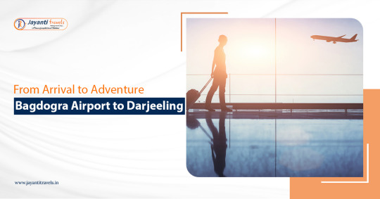
Bagdogra Airport offers you a ticket to explore the misty hills, majestic mountains and monasteries of Darjeeling. Bagdogra International Airport to date stands as the only international airport in North Bengal that allows easy access from any part of the world. With around 67km distance from Bagdogra airport to Darjeeling, the place is recognized as the best gateway to explore the magical beauty of Darjeeling.
Although, you will have to embark on a 3 hr of journey you will also be able to explore the beauty of the surrounding valleys and hill stations until you reach the city of Darjeeling. This article will present all the necessary details that you might need if you have been planning to reach Darjeeling from Bagdogra Airport.
The best way to reach Darjeeling
Darjeeling is one of the prominent hill stations of North Bengal that boasts its beauty with heritage sites, iconic landmarks and several attractions sites. Although there are a variety of transportation options to reach Darjeeling from Bagdogra Airport, renting a car is one of the fastest and best options to reach the city. Numerous tour operators offer affordable and quality car rental services from Bagdogra airport. You can book from a wide range of cars based on your travelling needs and budget for your hassle-free journey.
Apart from rental cars, tourists can also reach the city of Darjeeling with shared taxis, state buses and trains. Darjeeling Himalayan Railway is among the most favoured transportation modes. Recognized as the heritage of Darjeeling, the DHR will take you on a memorable journey that includes travelling through the dense forest and some of the tourist attractions sites including Batasia Loop.
Arrival from Bagdogra
Bagdogra International Airport is located in the Darjeeling district along National Highway 31, which offers one of the best places to start your journey. You can get to witness the misty hills, lush green mountains and dense alpine vegetation within a few minutes of the journey that you will be noticing throughout your journey. Multiple routes can be used to reach the city of Darjeeling which include Rohini route, Tindharia to Kurseong and Dudhia-Mirik route. Each of these routes offers a unique journey that can be chosen with consultation from your driver and tour operator. Out of the multiple routes, the Rohini route is the shortest one that takes around 3 hr to reach the city of Darjeeling. While the Tindharia to Kurseong is the longest route, it will let you travel through diverse landscapes offering breathtaking views of the Himalayas.
Adventures during your journey
Darjeeling is also known for its wide range of adventure offerings that can be experienced along your journey. Travelling to Darjeeling with a rental car therefore comes in handy when you want to indulge in various adventure activities. On your way to Darjeeling, you can get to witness the true beauty of the hills through vastly spread tea gardens, lakes, viewpoints, bustling markets and heritage sites.
Travelling through the misty hills, while listening to the honk of the Darjeeling Himalayan Railway and admiring the majestic beauty of the monasteries, the journey is sure to give you the travelling experience of a lifetime. Batasia Loop, Dali Monastery, Makaibari Tea Estate, and Happy Valley Tea Estate are some of the popular tourist attractions sites that can be visited during your journey.
The city of Darjeeling is among the best hill stations in the country and has been a must-visit place in North Bengal. Whether you are travelling with a rental car or a shared taxi, you will get to witness the true beauty of the hills offering you a travelling experience of a lifetime. The journey from Bagdogra Airport to Darjeeling is popular among tourists due to its ease of accessibility and better transportation options. However, you might need to consider the mode of transportation and routes as per your travelling needs.
0 notes
Text
5 Exciting Motorcycle Road Trips From Mumbai
Do you know one secret of this dream city? No, we are not talking about Bollywood here but something else. Mumbai is a city that provides easy access to some incredible riding destinations. With bike rental in Mumbai readily available, you can set out to explore lush green valleys, sea-kissed coastlines, and historic forts on two wheels. Whether you wanna see beaches or any other place, it’s all possible with the help of a bike on rent in Mumbai.
If you have the need for speed, these 5 motorcycle road trips from Mumbai will satisfy your wanderlust:
1. Mumbai to Mahabaleshwar
Just a 6-hour ride away, Mahabaleshwar makes for the ideal weekend getaway from Mumbai. The route takes you through misty ghats, waterfalls, and strawberry fields. Begin your ride early to avoid the heat and traffic.
Get a powerful bike on rent in Mumbai like Royal Enfield or KTM bike to breeze up the slopes. Stop on the way to view majestic Wilson Point and eat juicy strawberries! In Mahabaleshwar, take in the breathtaking vistas from spots like Arthur’s Seat and Elphinstone Point. For a thrill, ride to the source of the Krishna River at Panch Ganga temple.
With its cool climate, Mahabaleshwar lets you escape big city congestion and breathe pure mountain air. Don’t miss this rejuvenating ride from Mumbai.

2. Mumbai to Goa
This path along the Konkan coast is every biker’s dream. Passing through lush coconut groves and fishing villages, the 10-hour ride to Goa is absolutely picturesque. It’s best to take the NH66 highway and make pitstops at places like Srivardhan Beach, Redi Ganesh Temple, and Sawantwadi along the way. While riding through coastal Maharashtra, try lip-smacking Malvani cuisine.
Once in Goa, relax on golden beaches in Anjuna, Baga, or Palolem. Rev up and ride through Goa’s palm-shaded lanes to old Portuguese churches and forts. And then you can end the days with seafood by the beach and parties under the stars.
3. Mumbai to Aurangabad
For history buffs, the ride to Aurangabad offers the chance to explore ancient cave temples and Mughal monuments. Dedicate 2 days for this 330 km trip.
After an early start from Mumbai, you can reach Aurangabad by late afternoon. Rest up and get ready for an action-packed day seeing the Ajanta and Ellora caves which house remarkable Buddhist, Jain, and Hindu carvings.
The next day, visit Bibi Ka Maqbara, known as the mini Taj Mahal of the south. End with the ruins of Daulatabad Fort and Aurangzeb’s tomb before riding back. The scenic highways and historic sites along the way make this an unforgettable motorcycle journey.
4. Mumbai to Nasik
Nasik, located 180 km northeast of Mumbai, is the wine capital of India. Get a bike on rent in Mumbai like a Harley Davidson or Triumph to ride through endless vineyards and sample full-bodied Indian wines.
Along the way, stop at Shirdi to visit the famous Sai Baba temple. Once in Nasik, take a wine tour and stay at Sula Vineyards’ beautiful property. Visit the ancient Ramkunda temple and take a boat ride on the Godavari River for more spiritual sights.
Don’t miss Panchavati, the mythical place where Lord Rama resided during his exile. The ride from Mumbai gives you a chance to experience India’s vibrant wine culture and Hindu heritage.
5. Mumbai to Daman
For a quick coastal ride from Mumbai, head 100 km north to the beach town of Daman. Twist your throttle and zip past sites like Udwada and Vapi on well-paved highways.
Daman’s Jampore and Devka beaches offer pristine blue waters for swimming and water sports. Indulge in Portuguese-Goan fusion cuisine and shop for souvenirs near the colonial Daman fort. An evening stroll on the beach with stunning sunsets is the perfect way to end the ride.
With tantalizing seafood, Portuguese ruins, and waterfront views, Daman lets you experience Goa’s charms in half the time when riding from Mumbai.
Escape the Hustle and Ride Off Into The Sunset
Mumbai provides bikers with endless asphalt to fuel their passion for riding. Whether cruising along the Konkan Coast or riding up misty mountain passes, road trips from Mumbai let you find inner peace on your motorcycle. Always wear helmets and ride defensively for safety. Get a bike on rent in Mumbai from reputed companies like Rentnhop when planning your epic journey from Mumbai. Their well-maintained bikes and riding gear ensure a smooth trip. Don’t overpack - just strap a backpack to your bike and go.
Once the engines roar and the wheels glide, leave behind the city smog to embrace sun, salt, and spray. Let adrenaline and endorphins surge as you challenge hairpin bends and curvy coastal routes. Stop often to capture that perfect biker picture against stunning landscapes.
Conclusion
If you haven’t planned your day then you can read our other blogs or you can find some on Google. Biking into the great outdoors lets you soak in nature’s healing powers. You return with a rejuvenated spirit, mind, and belief in living life in the fast lane. Now get your motor running and head out on the highway to discover where the road and bike take you.
0 notes
Text
Southern Charms: Exploring Diverse Venues in North Carolina
Introduction: A Tapestry of Southern Elegance
North Carolina, with its diverse landscapes and rich cultural heritage, stands as a canvas for couples seeking a wedding infused with Southern charms. From the misty Blue Ridge Mountains to the sun-kissed shores of the Outer Banks, North Carolina offers a myriad of wedding venues, each contributing to the tapestry of Southern elegance. In this exploration, we delve into the diverse venues that define the charm of the South, creating unique and memorable settings for couples to say "I do."

Venue 1: Mountain Majesty in Boone
Nestled in the scenic beauty of Boone, North Carolina, mountain venues bring forth a unique charm that is both majestic and intimate. Imagine exchanging vows against the backdrop of rolling hills and mist-covered peaks. Mountain venues in Boone provide couples with a setting that captures the essence of Southern charm infused with the tranquility of nature. Whether it's an outdoor ceremony with panoramic views or a rustic lodge nestled in the mountains, Boone offers a charming escape for couples seeking a wedding immersed in the allure of the North Carolina high country.
Venue 2: Coastal Romance in Beaufort
The coastal town of Beaufort introduces a different facet of Southern charm with its venues that embrace the romance of the sea. From historic waterfront estates to quaint beachside settings, Beaufort provides couples with a coastal charm that is both elegant and laid-back. Picture a beach ceremony with the sound of waves as your backdrop or a reception in a historic waterfront venue adorned with Southern hospitality. Beaufort's coastal venues invite couples to experience a unique blend of Southern charm and coastal allure, creating a wedding atmosphere that is both timeless and refreshing.
Venue 3: Historic Elegance in New Bern
Steeped in history, the town of New Bern showcases venues that exude a sense of historic elegance. Historic homes, ballrooms, and gardens offer couples a glimpse into the rich heritage of the South. The cobblestone streets, gas lanterns, and centuries-old oak trees become a part of the wedding story, creating an atmosphere that is infused with Southern charm. New Bern's historic venues provide couples with an opportunity to celebrate their special day in a setting that resonates with the timeless traditions of the South, making history a part of their love story.
Venue 4: Countryside Retreat in Winston-Salem
Winston-Salem, with its rolling countryside and charming estates, introduces couples to venues that offer a countryside retreat within a Southern backdrop. Picture exchanging vows in a blooming garden, surrounded by acres of open fields and towering trees. Winston-Salem's countryside venues provide a sense of tranquility and charm, creating an escape from the bustling city life. The rustic barns, sprawling lawns, and Southern-inspired landscapes offer couples a canvas to paint their wedding dreams with the pastoral charm of the countryside.
Venue 5: Cultural Fusion in Charlotte
As a bustling metropolis, Charlotte embraces cultural diversity and modern sophistication while preserving its Southern roots. Venues in Charlotte become a fusion of tradition and contemporary flair. From sleek urban spaces to cultural centers that celebrate diversity, Charlotte's venues cater to couples seeking a dynamic and eclectic atmosphere. The cityscape, combined with Southern hospitality, creates a charming backdrop for couples who want their wedding to be a reflection of the vibrant energy and cultural richness of Charlotte.
Conclusion: Crafting Unforgettable Moments in Southern Charm
Exploring diverse wedding venues in North Carolina reveals a spectrum of Southern charms that cater to every couple's unique vision. Whether surrounded by the majestic mountains of Boone, the coastal romance of Beaufort, the historic elegance of New Bern, the countryside retreat of Winston-Salem, or the cultural fusion of Charlotte, each venue contributes to the Southern narrative in its own distinct way.
In the tapestry of Southern charms that North Carolina unfolds, couples find a wealth of options that allow them to craft unforgettable moments. The diverse venues serve as more than just locations for ceremonies and receptions; they become stages where love stories are celebrated with the warmth, elegance, and unique charm that define the South. North Carolina's wedding venues invite couples to explore the various facets of Southern charm, ensuring that their special day is a reflection of their love, style, and the rich cultural heritage that surrounds them.
0 notes
Text


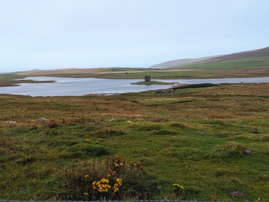


Sept 3 Benbecula to North Uist (74.4 km)
We let ourselves sleep in today since it was going to be a shorter ride. I know what you're thinking, 74 km is not much shorter than 86 km...this is true, although, still shorter, the original plan was for a 47 km day. Don't ask me how, but I wrote down the wrong distance plus we added a side detour. Anyway, back to sleeping in, we slept until 8:45 am, finally able to catch up and I felt much more human today...at least at the beginning of the day.
We set out into the wind and rain, and boy was it windy: 42 km/hr, thankfully about half or more of which would be a tail wind, the rest proved to be quite challenging. Being surrounded by the raw beauty of these islands helped distract my brain from my burning legs as I looked out into the vastness. Crashing waves, howling winds, misty mountains and too many sheep and cows to count. Today would be mostly about the journey. Being a Sunday, there was very little open, but oddly the gin distillery was open! We stopped by, and though I dare not taste anything with so few km under the belt, we did pick up a few tiny taster bottles. Rightly named, Downpour distillery was quite an eclectic place with more customers than I would expect on Sunday at 11:30 AM. We got going to stop at a local grocery store, the only one for miles and miles and the only one open on Sunday. We picked up some premade spaghetti, a few eggs for breaky and a beer and a small wine for later.
Our first big stop was at the first set of standing stones we would see. We ended up eating at the little hotel restaurant that lay on the same property. A good cup of coffee and a hot meal and two little dogs who gladly accepted pets and cuddles. We met a few locals who gave us the run of things, what to see and what to skip. We headed out to hike up to the very unsheltered hill where the stones were. Battered by the elements, and contending with puddle hopping we made it up. Really beautiful view despite the spraying misty rain and strong winds. I got out the good camera and snapped some photos while Ken took shelter behind one of these ancient stones. Onward for the next 25 km...sorry 45 km, oops.
More highland cows and stunning landscape to remind us of why we're here. Also helps that the worst traffic we would come across were the rogue sheep meandering on the sides of the road. But. The. Wind. The. Rain. What can you expect on islands off the North coast of Scotland? Embrace it, but heck, I wouldn't want to be traveling in reverse. North Uist became less and less inhabited the further we went. Kilometers would go by with just a small crofting home here and there. Still, something about this place is almost, mystical. It's an odd feeling to have your heart pounding as you're fighting a cross wind up a hill, and yet be oddly at peace and calm. As though there is nothing else in the world in this moment, except this place and this bike.
Another mile, mile and a half, I kept saying to myself. Reminiscing of our friend, Joris telling us this exact phrase as we hiked in Tobermory. We had a good laugh, and in that moment I had wished I had a Joris to blame for the error in distance. Alas, I could only blame myself, but no harm, each km was worth it. Ken of course was an excellent sport, he giggled in his Kenny laugh, saying he was darn glad I planned this trip, because if he had made this error, I would have been mad. Hahahaha! I'm ashamed to say he's probably right. What a guy though, can see me in all my hypocrisy and not rub it in. Just keep spinning. Just keep spinning (thank you Dori).
We did it, 74 km...only slightly more than planned (originally 47 km). Perhaps it was a moment of dislecsia? Ask my brother, I used to write in perfect mirror image. We landed in at our pod (a common accommodation out here, with all you would need in kind of hard walled yurt). Our grocery store premade spaghetti was awesome, and the wine even better.
No rest for these ol' legs. 86 km on deck tomorrow. If you don't hear from me, I opted for a night in a field snuggled up to a highland cow. This may well be my life now. Me and the cows. Go on without me Ken, God speed.
0 notes
Text
Facts about Manaslu Region Trekking

Are you thinking of doing Manaslu trekking for your next trip? Many people don't know that the name Manaslu comes from the Sanskrit word "Manasa" which means "Mountain of Spirit". Manaslu is located in the North side of Gorkha region. Manaslu is a very beautiful mountain and know as "wall of snow and ice suspended in the sky". Manaslu region trekking is a very adventurous and best trekking where you can see the most spectacular mountains in the world. If you want to experience the unexplored area of Nepal then Manaslu region trekking is best for you. Join this trek and see the most spectacular mountains in the world through your own eyes. You'll have the best experience in this trek. Here are some facts about travelling in Manaslu Region:
1. Mount Manaslu is the eight highest mountain in the world. It is located about 40 miles east of Annapurna. Its height is 8,156m. Mount Manaslu was opened for tourist and traveler in 1992. The high peaks of the mountains and the glaciers of the valleys offer easy access from all sides, ending with a peak that dominates the surrounding landscape and is a sight to behold when seen from afar. The other peaks that surround Manaslu are Ngadi Chuli, Himalchuli and Baudha.
2. Trekking in Manaslu is regionally spectacular. You’ll definitely enjoy the cultural of Manaslu region because they are culturally fascinating. Travelers love trekking in Manaslu region as it offers the perfect picture of the mountains and best adventure destination. Manaslu is a combination of rich cultural heritage so it is loved by travelers for its cultural heritage.
3. Manaslu region trekking offers so many enjoyment. This trekking gives you an opportunity to see Mount Manaslu, Tsum Valley, Nubri Trek and Manakamana Temple. This Manaslu trek sometimes starts from Aughat Bazaar or sometimes from Gorkha Bazzar and ends at Besisahar. Besisahar is the starting point of the Annapurna Circuit.
4. There are not so many people doing this Manaslu trekking, which make this trekking less crowded. Your journey will be more fun and unspoiled. Recently, Manaslu Circuit trekking has become a tea house tour by opening the misty wood-shingled villages of the Nupri Valley. Adventurers are allowed to explore many other places as well. Part of the journey falls across the Himalayas, in a valley called Tsum.
5. This trek is all about a beautiful trip with spectacular views of Manaslu and passing through authentic Hindu and Tibetan villages. You will feel like walking through the green countryside, passing small Hindu villages. When you head to north side, you will see lush greenery and small Tibetan villages that is cluster under Manaslu’s sweeping north face.
6. You will experience a wonderful homestay in this trek. You will be living with the Tamang family. Tamang people are known as original horse traders of Nepal. Trekkers can go for “walk in the clouds” above Tiru Danda. You can see the amazing views from Annapurnas to Ganesh Himal from Tiru Danda.
7. Toshio Imanishi and Gyalzen Norbu, the members of a japanese expedition, were the first people to climb Mount Manaslu. They climber Manaslu on May 9, 1956. There is a saying that “just as the British consider Everest as their mountain, , Manaslu is Japan's mountain”.
8. The route you will be taking in this trekking is going through mountains that can experience the effects of rain, soil erosion and rock formations. Seeing yaks, hypothermia and altitude sickness are common. You can say that Manaslu trekking is a test to check your endurance.
9. The Tsum Valley Trek is one of the best trek that you shouldn’t miss. This Tsum Valley Trek in the region offers very beautiful views of the Ganesh Massifs. Its height is 7,000m. Travellers can visit here and explore the cultural of Tsumba people. The cultural of Tsumba people is influenced by Tibetan.
10. The Budi Gandaki is also known as Nupri, where the Tibetans are living. The Tibetans living in Nupri are descendants of Tibetan immigrants. There is so many similarities between them, including their dress, speech, custom and traditions. The mountain views at Nupri are breathtaking and the Larke Pass (5,213m) is a spectacular Himalayan pass to cross.
Manaslu Trekking in Autumn
Autumn is one of the time for trekking in Nepal. As the autumn weather is dry and clear so this makes the days sunny and very clear.
Manaslu Trekking in Spring
Spring is also another time that is considered to be good time for Manaslu trekking because the weather is clear. Sometimes it might get a little colder but still it’s fine for the trip. The best thing about trekking in spring is that you get chance to see flowers blooming.
Manaslu Trekking in Summer
Because it’s warm and wet weather in summer so it’s hard to see the best view of mountains in summer.
Manaslu Trekking in Winter
In winter, the low temperature makes trekking hard. As the winter days are short so the long nights and cool temperature decrease the number of people trekking in winter.
Short Manaslu Circuit Trek
#manaslu circuit trek permit#manaslu circuit trek highlights#manaslu circuit trek cost and itinerary#manaslu circuit trek blog#manaslu circuit trek distance
0 notes
Last Seen Blogs

willow1122
Whim

jehanprouvaire
chew on me

lildarkness34
submit on kik:lilwoodman

skidcd-megamix
CALL ME SKID💥💥