#azimuthal equidistant
Text
KAVRAYSKIY VII vs AZIMUTHAL EQUIDISTANT
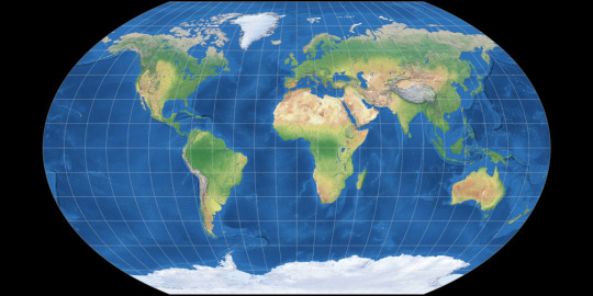

Kavrayskiy VII Pseudocylindrical Compromise
Created in 1939 by Vladimir V Kavrayskiy (Sometimes transcribed from Cyrillic differently, Kavraisky seems to be the most common alternative, used by G.Projector) for use as a general-purpose compromise projection in Soviet atlases. It has seen little use outside the area of the former Soviet Union, where usually the Robinson is used instead.
Mathematically it is the same as the Wagner VI projection horizontally compressed by sqrt(3)/2, however it has very low distortion values on many metrics, comparable to the Winkel Tripel.
This projection is mentioned in passing under the Winkel Tripel's entry in xkcd 977.
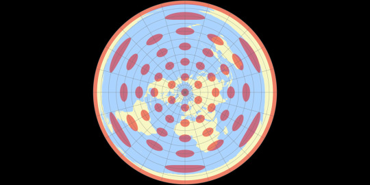
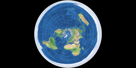
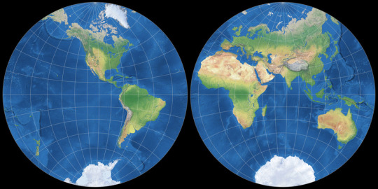
Azimuthal Equidistant Azimuthal Equidistant
While it may have been known as far back as the ancient Egyptians, the Azimuthal Equidistant projection was first described by al-Biruni around the year 1000. As an equidistant projection all distances from the chosen centre point can be measured correctly, meaning it is often used for things like missile range maps and other uses where only the distance from a single point is important.
Because of its circular shape, the polar aspect is often used for maps in logos such as the emblem of the UN. It can also be cropped to show a single hemisphere, and can be shown as two hemispheres side by side in the equatorial aspect like this.
[link to all polls]
Political:
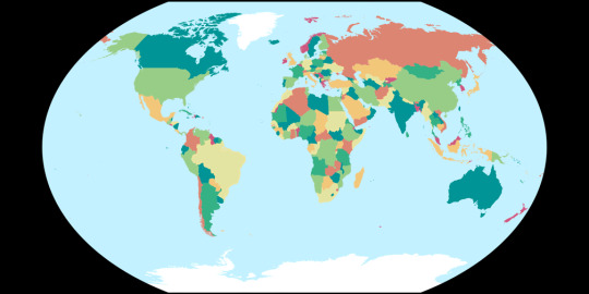
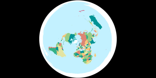
Tissot's Indicatrices:
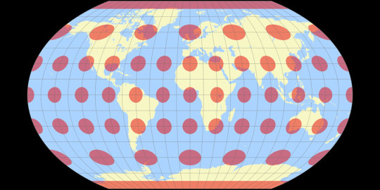
Images created by Tobias Jung (CC BY-SA 4.0) from map-projections.net
12 notes
·
View notes
Text
Peta bumi menjadi dua kubu besar antara Rusia dan Amerika saat perang melawan Nazi Jerman
Peta dunia menjadi dua kubu Besar, INI adalah peta perjuangan dunia yang akan menandai titik balik peradaban. Perjuangan membagi dunia menjadi dua kubu besar: mereka yang mendukung kita (dalam berbagai derajat) dan mereka yang melawan kita (juga dalam berbagai derajat). Di antara ekstrem-ekstrem ini ada yang netral, ada yang condong ke satu arah, ada yang lain. Semua gradasi ini dijelaskan dalam kunci di halaman yang berlawanan.
Beberapa poin penting mengenai peta ini harus diperhatikan. Yang pertama adalah bahwa seluruh konflik berputar di sekitar A.S. Ini bukan hanya karena penempatan A.S. di pusat penyebaran: melainkan terletak pada sifat perjuangan. AS adalah poros (a) karena posisi geografisnya, yang merupakan pusat lautan; selengkapnya klik dibawah 👇.
#Peta dunia menjadi dua kubu besar#TERSENTRIFUSI DUNIA.#PROYEKSI EQUIDISTANT AZIMUTHAL POLAR UTARA Prinsip proyeksi ini dapat diilustrasikan oleh seorang penari#PROYEKSI EQUIDISTANT AZIMUTHAL POLAR UTARA Prinsip proyeksi ini dapat diilustrasikan oleh seorang penarip#Peta bumi bajak laut#Peta bumi seorang nelayan#Peta bumi seorang penjelajah dunia#Peta bumi menurut agama#Peta bumi peradaban Yunani kuno#Peta bumi peradaban Islam#Peta bumi menurut sejarah
0 notes
Photo
World map with azimuthal equidistant projection centered at the north pole. Borders of the late 90's-early 2000s.
114 notes
·
View notes
Text
Riley Inventive Options 1943 Flat Earth World Map | Polar Azimuthal Equidistant
Value: (as of – Particulars)
Riley Inventive Options 1943 Flat Earth World Map | Polar Azimuthal Equidistant Projection Map | Massive Wall Artwork Poster Print (3 Sizes) (11"x16")GREAT POSTERS FOR THE OFFICE: Are you struggling so as to add that basic contact of magnificence to a room in your workplace? Classic type posters assist broaden your adorning choices and harness the ability of…
View On WordPress
0 notes
Text
Peta bumi bulat termaksud Peta Azimut karya Al-Biruni
Bola Dunia Itulah peta bumi bulat Yang sebenarnya.
Membuat beberapa proyeksi Bumi pada bidang datar, seperti proyeksi azimuthal-equidistant dan nicolosi.
Sejarah Marmer: Biru Peta bumi bulat diwarnai akan terlihat seperti asli. The Blue Marble
Karya Al-Biruni yang Menciptakan gambar Bumi bola Atau peta bumi bulat yang sekarang dianggap bumi nyata padahal itu adalah peta.Proyeksi azimuthal…

View On WordPress
#Apa Benar Al-Biruni Sempurnakan peta bumi bulat untuk dijadikan bola dunia#Bagaimana Al-Biruni mengukur keliling Bumi?#Bola Dunia termaksud Peta Azimut karya Al-Biruni
0 notes
Text

Johngalli’s interest expanded into star maps temporarily in addition to planetary interests.
At that point in his life, he attempted to memorize the inner-workings of the the azimuthal equidistant projection. This would lead him to eventually get the three tattoos of the world on his back and shoulders.
He would receive these not too long after his cataracts began to truly injure his sight to an irreversible extent.
#headcanon ;; johngalli a#something short-- But I was doing some research on star maps and it's relation to pi#and started to learn more about azimuth--for the most part the azimuthal equidistant projection#I really like the idea of Johngalli being quite good at math and astronomy(he does have the planet on his back)#(and those symbols on his cheeks look AWFULLY like pi ))#but something short uvu i'm in a big mood for this boy
2 notes
·
View notes
Photo

UN redesign
from /r/vexillology
Top comment: Definitely prefer it to the weird azimuthal equidistant projection on the current one
35 notes
·
View notes
Photo
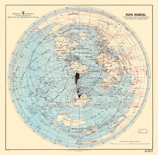
An azimuthal equidistant projection centered on Argentina
162 notes
·
View notes
Text
AZIMUTHAL EQUIDISTANT vs STEROGRAPHIC
Azimuthal Equidistant Azimuthal Equidistant
Round 1: [Azimuthal Equidistant vs Kavrayskiy VII]
Stereographic Azimuthal Conformal
Round 1: [Stereographic vs Eckert IV]
Two azimuthal projections face off in this poll, who will win between these two projections that were both first used by the Ancient Egyptians for star charts.
While the images I'm using here show them in different aspects, both of them can be used differently, the stereographic projection is usually shown in two hemispheres as it can't show the whole world from one tangent point, while the azimuthal equidistant is usually shown in a single circle due to its equidistant property.
If you check out the direct comparison below you can see the difference when they both use the same equatorial hemispheres, the stereographic projection being conformal gives it more accurate shapes, but of course also leads to greater size distortion.
[Direct comparison on map-projections.net]
[link to all polls]
5 notes
·
View notes
Text
Ternyata Bola Dunia peta bumi bulat yang selama ini kita tidak ketahui
Peta bumi bulat yang disempurnakan oleh Al-Biruni.
Karya Al-Biruni yang Menciptakan gambar Bumi bola Atau peta bumi bulat yang sekarang dianggap bumi nyata padahal itu adalah peta.Proyeksi azimuthal equidistant adalah proyeksi peta azimut
Selengkapnya klik disini.

Apakah orang Romawi mengira planet adalah dewa?
Planet Sebagai DewaBagi orang-orang dari banyak peradaban kuno, planet dianggap sebagai dewa . Namun untuk planet adalah nama Romawi untuk dewa-dewa ini. Misalnya, Mars adalah dewa perang dan Venus adalah dewi cinta dsb.
#Peta Bumi bulat#Bola dunia itulah peta bumi bulat#Benarkah bola dunia adalah peta bumi bulat#Bola dunia yang disempurnakan oleh Al-Biruni#Peta bola dunia yang disempurnakan oleh Al-Biruni#Peta Bumi bulat disempurnakan oleh Al-Biruni
0 notes
Photo
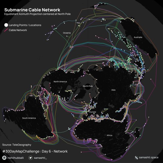
Network of submarine cables that enable internet connectivity across the globe in a different perspective using equidistant azimuth projection.
by @samashti_
199 notes
·
View notes
Text
世界の政府は、世界は丸いと大衆に信じさせようとしています。
しかし、政府が世界の実際の構成について問題に対処する方法を知りたいとき、彼らは極座標方位平板地図を参照する。
実際、米軍は何百人もの兵士や民間人を使って、展開地域の正確な地図を作成しています。
その地図が公開されることはほとんどありません。
下の写真は、ホワイトハウスが公開し、インターネットに掲載されているホワイトハウス・シチュエーション・ルームの公式ビデオツアーの一コマで、ホワイトハウス・シチュエーション・ルームにある方位等角地図の極座標投影図です。
肝心なときに、アメリカ政府が知りたがっているのは、地球の本当の姿、つまり平らな地球なのです。
The governments of the world want the masses to believe that the world is round. However, when governments want to know how to address issues on the real configuration of the world, they reference a polar equidistant azimuthal flat earth map. Indeed, the U.S. Military employs hundreds of soldiers and civilians in producing accurate maps of areas of deployment. Those maps are almost never made public. Below is a frame from an official video tour of the White House Situation Room, published by the White House and posted on the internet, showing a polar projection of an azimuthal equidistant map in the White House Situation Room.When it really counts, the U.S. Government wants to know the real configuration of the earth: a flat earth.
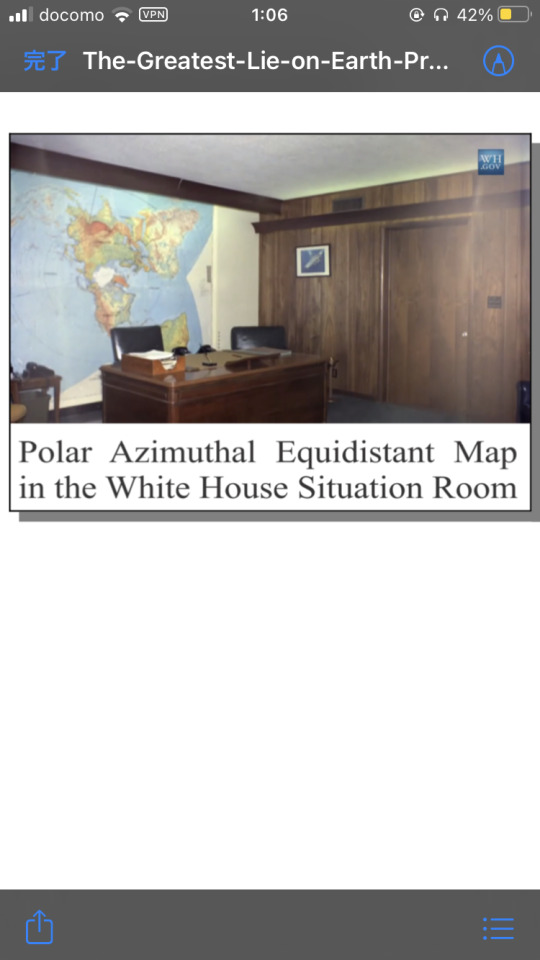
『The-Greatest-Lie-on-Earth-Proof-That-Our-World-Is-Not-A-Moving-Globe』より引用
1 note
·
View note
Photo
JEHOVAH OCCULT BIBLE [JOB] WITNESS Me [ME = U.S. Michael Harrell = TUT = JAH] DEEP IN:side Cosmic Darkness [HEAVEN] since iBEE A Highly Official… U.S. Ancient [USA = PREHISTORIC] Ægyptian American [ATLANTEAN] SPIRIT DWELLER [EXTRATERRESTRIAL] from Our Mysteriously UNSEEN [MU] Subterranean Earth of Azimuthal [SEA] Equidistant Technologies [E.T. = SET] Scientifically SKY Engineering Earth [SEE] Grid Networks with My Highly Complex [ADVANCED] Cosmic Algorithmic [CA] Computational [Compton] STAR Mathematics from Ancient Nautical [MAN] Records of Private Intellectual PROPERTY [I/P] RIGHTS Securely Encrypted by Classified [SEC] Intel Agencies [CIA] on My Highly Official… U.S. UFO Pentagon Computer [PC] of Integrated Application [CIA] Systems of SIRIUS Interstellar Cloud Architecture Telecommunicating [iCAT] Astronomically Intelligent ANUNNAKI [AIA = AMÚN] SUN GOD [RA] MESSAGES [RAM = RAMESES] 2 My Highly Official… U.S. Ancient [USA = PREHISTORIC] Ægyptian American [ATLANTEAN] Subterranean SUN Continent of Antediluvian [CA] ATLANTIS & LEMURIA [CAL = CALAFIA] in 2021 https://www.instagram.com/p/CNv2vrDBO_S/?igshid=1kuj0fpx7ox8m
1 note
·
View note
Photo
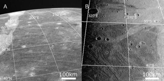
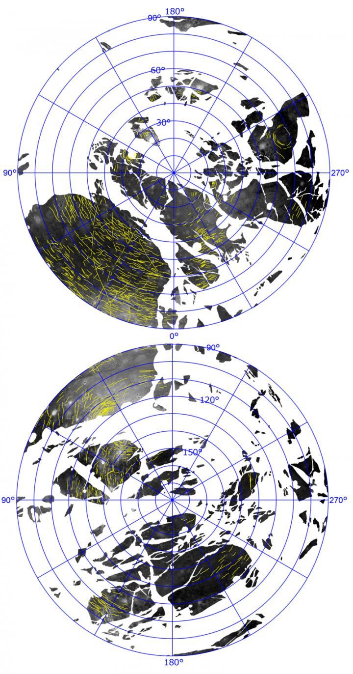
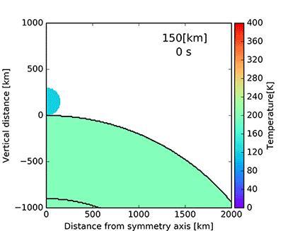
Huge ring-like structure on Ganymede's surface may have been caused by violent impact Researchers from Kobe University and the National Institute of Technology, Oshima College have conducted a detailed reanalysis of image data from Voyager 1, 2 and Galileo spacecraft in order to investigate the orientation and distribution of the ancient tectonic troughs found on Jupiter's moon Ganymede. They discovered that these troughs are concentrically distributed across almost the entire surface of the satellite. This global distribution indicates that these troughs may be actually part of one giant crater covering Ganymede. Based on the results of a computer simulation conducted using the "PC Cluster" at the National Astronomical Observatory of Japan (NAOJ), it is speculated that this giant crater could have resulted from the impact of an asteroid with a radius of 150km. If so, the structure is the largest impact structure identified in the solar system so far. The European Space Agency's JUICE (Jupiter Icy Moon Explorer) mission, which will be launched in 2022 and arrive in Jupiter's system in 2029, aims to increase our knowledge regarding Jupiter's satellites, including Ganymede. It is hoped that this exploration will confirm the results of this study and further advance our understanding of the formation and evolution of Jupiter's satellites. The research team consisted of Kobe University Graduate School of Science's Assistant Professor HIRATA Naoyuki and Professor OHTSUKI Keiji (both of the Department of Planetology), and Associate Professor SUETSUGU Ryo of National Institute of Technology, Oshima College. The paper for this study was published online in Icarus on July 15. Main Points • Many furrows, or trough formations, have been previously observed on the surface of Ganymede, one of Jupiter's moons. • The research group comprehensively reanalyzed image data of Ganymede's surface obtained by NASA's Voyager 1, Voyager 2 and Galileo spacecraft. • The results revealed that almost all of these furrows on the surface of Ganymede appear to be in concentric rings centered at a single point, indicating that this global multiring structure may be the remains of a giant crater. • The radial extent of the multiring measured along the satellite's surface is 7800km. Therefore, if it is actually formed by an impact, it is the largest vestigial impact crater discovered in the solar system so far. • The results of the numerical impact simulation indicated that an asteroid with a radius of 150km impacting Ganymede at a speed of 20km/s would explain the observed structures on the satellite's surface. Research Background Both Voyager 1 and Voyager 2 have closely approached Ganymede in 1979 and 1980 respectively, taking detailed images of the surface. In addition, the Galileo spacecraft orbited Jupiter from 1995 to 2003, obtaining a large amount of Ganymede image data. Ganymede is the largest satellite in the solar system and is bigger than both Pluto and Mercury. The formation and evolution of Jupiter's moons including Ganymede is strongly connected to the formation and evolution of the Jupiter system, and by extension, of the solar system. Consequently, there are various ongoing and planned spacecraft missions to explore the satellite system, including NASA's JUNO mission that is ongoing, the Europa Clipper scheduled to perform a detailed investigation of Jupiter's moon Europa in around 2030, and the aforementioned JUICE mission. The study was conducted with the aims of clarifying one aspect of the formation and evolution of Jupiter's satellites and of contributing towards these spacecraft missions. The group reanalyzed image data of Ganymede. In particular, the researchers focused on furrows (Top image), tectonic troughs that are believed to be the oldest surface features on the satellite. Therefore, the research group hypothesized that they could reconstruct the early history of Ganymede by analyzing these geological formations. Research Findings Ganymede's surface is categorized into areas of Dark Terrain and Bright Terrain. Dark Terrain is extremely old and has many remaining craters, as well as trough formations. Bright Terrain is comparatively recent, with hardly any craters. These two types of terrain are not coherently arranged and are randomly distributed over Ganymede's entirety. Furrows are believed to be Ganymede's oldest geological features because they are only found on Dark Terrain and many impact craters (*1) have been formed on top of them later on. This study reanalyzed the distribution of these trough formations over Ganymede's entire surface, revealing for the first time that almost all of these furrows are concentrically aligned around a single point (Figure 2). The study showed that these furrows form giant, concentric rings over the entire satellite. From this, it can be assumed that there was a giant multiring impact crater which covered the entire surface of Ganymede before the formation of the Bright Terrain areas. A similar ring structure known as the Valhalla Crater remains on the surface of Callisto, another satellite of Jupiter. Until now, the Valhalla Crater has been the largest identified multiring crater in the solar system, with a radius of approximately 1900km. However, the multiring crater on Ganymede has a radial extent of 7800km measured along the satellite's surface. The research team conducted a simulation to estimate the scale of the impact that formed this giant crater. This was carried out using the "PC Cluster" at the National Astronomical Observatory of Japan (NAOJ). The results indicated that an asteroid with a radius of 150km impacting Ganymede at a speed of 20km/s would be sufficient to form the observed structures on the satellite's surface (Figure 3). It is believed that such an impact occurred around 40 billion years ago. Further Developments The discovery that the aftermath of a large-scale impact remains on Ganymede's surface is greatly significant in terms of the satellite's formation process and evolution. For example, Jupiter's satellite Callisto is around the same size as Ganymede, however it is believed that it doesn't have an internal structure composed of differentiated layers. On the other hand, Ganymede is thought to be composed of a differentiated layer structure consisting of rock, iron and ice. An enormous amount of heat is necessary to form these differentiated layers. It is possible that the aforementioned large-scale impact could have been the source of this heat. This study's discovery will also have substantial significance for the Ganymede exploration programs scheduled in the coming decades. The image data from both Voyager and Galileo missions only provide partial views of the satellite's surface. It is hoped that future explorations will be able to confirm or test this study's results by conducting detailed investigations into the multiring formations and whether or not there are any other remains of large-scale impacts. Hopefully, this will result in a deeper understanding of the origins and evolution of Ganymede as well as Jupiter's other moons. TOP IMAGE....The Dark Terrain and Bright Terrain areas can be recognized, with concurrent furrows present in these Dark Terrains. CREDIT NASA CENTRE IMAGES....Above: Azimuthal equidistant map centered at 20° south 180° west showing Ganymede's Dark Terrain and furrows (indicated by yellow lines). Below: Azimuthal equidistant map of Ganymede's surface centered at 20° north and 0° west. This shows the opposite hemisphere of Ganymede to the top image. The white areas indicate Bright Terrain. CREDIT NASA LOWER IMAGE....It is speculated that this would result in a violent impact. Note: The sharp vertical distribution of the material along the vertical axis that can be seen at a distance of 0km at 12000 seconds is likely a numerical artifact caused by the boundary conditions in the simulation, but we confirmed that this does not affect the main results of this study. CREDIT Naoyuki Hirata
9 notes
·
View notes
Text
Ilmuwan flat earth akan mengembangkan Aplikasi zodiak_Bintang
Ilmuwan flat earth akan mengembangkan Aplikasi zodiak_Bintang
Earth zodiac data
Apk atau Aplikasi jam flat earth sangat mengagumkan.
Flat Earth Sun & Moon Clock menunjukkan di mana Anda berada dan di mana matahari dan bulan berada dalam perjalanannya mengelilingi muka bumi seperti yang ditunjukkan pada peta Azimuthal Equidistant. Anda dapat melihat di mana waktu siang dan malam serta posisi dan fase bulan saat matahari perlahan-lahan mengitarinya setiap…
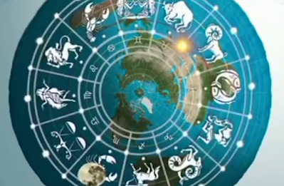
View On WordPress
0 notes
Photo
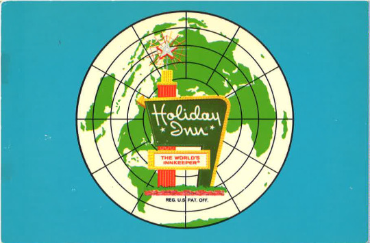
#WorldMapWednesday
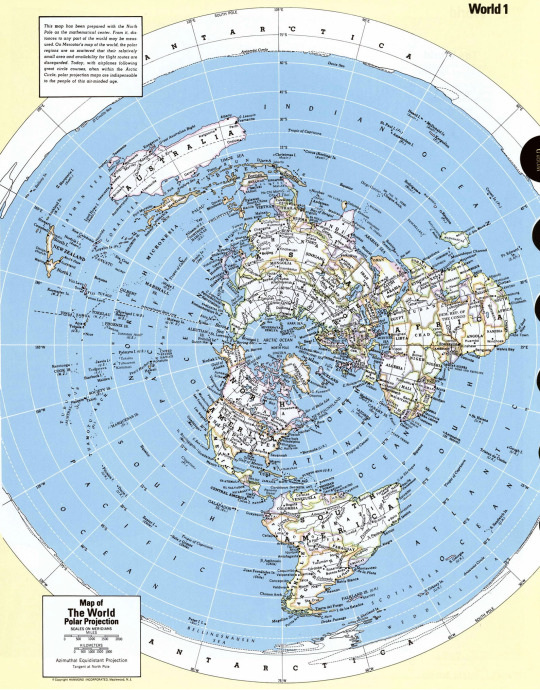
Today’s post comes from our postcard collection! Holiday Inn made postcards for several of their locations with this world map on them in the 1960′s. This projection is the Azimuthal equidistant, which means that the distance from the center is preserved.
Our postcard collection has over a thousand postcards from the United States and all over the World!
24 notes
·
View notes
Last Seen Blogs
withoutatrace8
creative director
nebulousparky
ur local ghoul

brunette-bitch77
***FLAWLESS

tobznoobs-blog
utter ramblings of an amateur

saejimin
xx