#chaudanne
Text
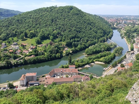
Besançon - the place to be !
(dedicated to @snowboardcatgirl )
Where I live, where I run
#besancon#besac#doubs#river#franche-comte#boucle#chaudanne#cityscape#landscape#hills#where i run#running#chemin faisant#runner#run#runing life#view#panorama
115 notes
·
View notes
Text
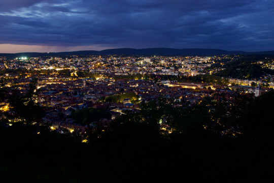
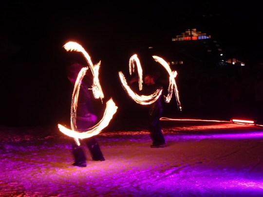
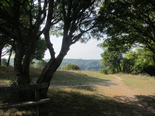
Semaine 38 • Nuit
Retour à l'extérieur pour la photo de la semaine! Même si le temps n'était pas trop de la partie, avec une heure bleue largement gâchée par de gros nuages bien gris, c'est toujours un plaisir que de monter à Chaudanne pour (re)découvrir la vue sur la Citadelle et la Boucle. La nuit, lorsque des milliers de petites lumières éclairent rues et immeubles, on dirait vraiment un décor de modélisme...
2 notes
·
View notes
Text
Welterbe (auf)gespürt und (er)fahren - F - Festungsanlagen von Vauban
Militärische Befestigungsanlagen habe ich auf meiner Reise zu den Welterben schon an einigen Stellen besucht, mir fallen da sofort Venedig, Helsinki oder Luxemburg ein. Auch an den Grenzen Frankreichs besuche ich einige Arbeiten des Bauingenieurs Vauban, mein erster Stopp führt mich nach Camaret-sur-Mer.
Sébastien Le Prestre de Vauban (1633-1707) war ein Militäringenieur von König Ludwig XIV. Seine Projekte stehen seit 2008 auf der UNESCO-Welterbeliste und veranschaulichen eine bedeutende Periode der Militärgeschichte. Vauban entwarf rationelle, an die vorgegebene Landschaft angepasste Befestigungssysteme und verband darin militärische Strategie, Architektur und Konstruktion, Bauingenieurwesen sowie wirtschaftliche und soziale Organisation.

Zum Welterbe gehören 12 der schönsten Beispiele seiner Arbeit, wie Städte, die von Vauban von Grund auf neu bauen ließ, Zitadellen, städtische Bastionsmauern und -Türme, Berg- und Seefestungen, eine Bergbatterie und zwei Bergkommunikationsstrukturen.
Karte - https://fr.wikipedia.org/wiki/Fichier:Carte_des_sites_majeurs_de_Vauban.svg
Diese Stätten verkörpern den Höhepunkt der klassischen Befestigungsanlagen und sind typisch für die westliche Militärarchitektur. Bis Mitte des 19. Jahrhunderts spielte Vauban eine wichtige Rolle in der Geschichte der Festungsanlagen in Europa und seine Theorien zur strategischen Militärarchitektur wurden von Amerika bis in den Fernen Osten angewendet. Hier geht zum Einführungsvideo.
Auf die erste Befestigungsanlage, die allerdings nicht zu den Welterbestätten gehört, stoße ich eigentlich eher durch Zufall in Nord-Pas-de-Calais in der Stadt
Bergues
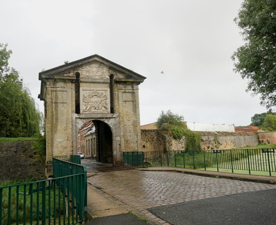
An der französischen Ostgrenze befindet sich eine Reihe von Festungsstädten, Bergues ist eine davon. In der Stadt spielt der Film - Willkommen bei den Sch'tis - und ich möchte mir hier natürlich den Belfried anschauen. Ich parke neben der recht beachtlichen Stadtmauer mit dem Wassergraben und betrete das Zentrum durch die imposante Porte de Cassel aus dem Jahr 1752.


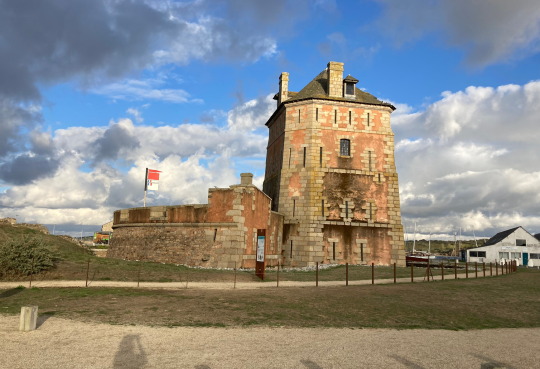
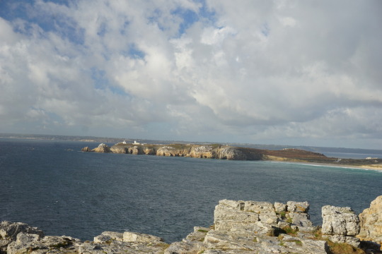
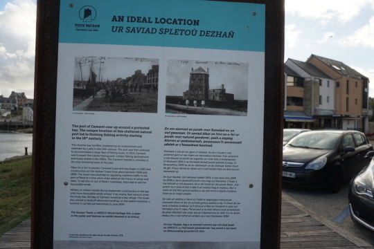
Camaret-sur-Mer
Nach Camaret-sur-Mer komme ich ganz gezielt, um mir den dortigen Vauban-Turm anzuschauen. Die Sonne scheint und ich fahre zuerst zu den felsigen Klippen mit dem Blick auf die Westspitze Frankreichs, der Pointe du Raz.

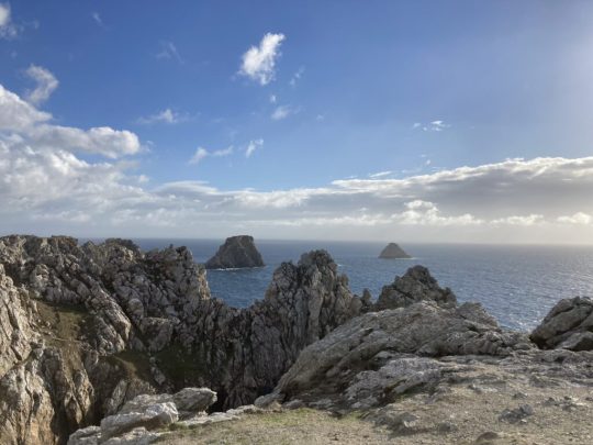

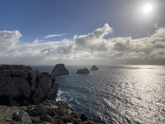

Ich bewege mich hier auf historischem Boden. Die Landzunge war heiß umkämpft, daran erinnern die Bunker an der Pointe de Pen Hir.


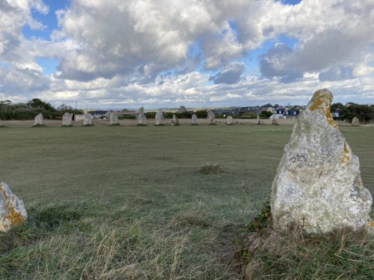
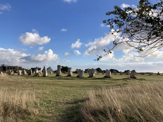
Camaret hält auch noch weitere Sehenswürdigkeiten aus früheren Zeitaltern für mich bereit. Unweit der Spitze steht ein bemerkenswerter Steinkreis, die Steinreihen von Lagatjar.
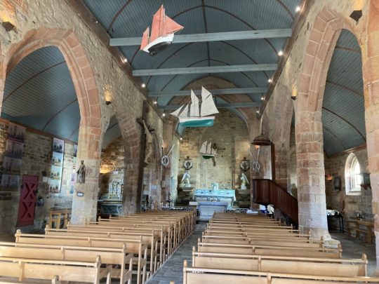
Der Vauban-Turm erhebt sich imposant neben einer kleinen Kirche und hinter Schiffsfriedhof am Hafen des Ortes und macht heute seinem Namen - Goldener Turm - den ihm Vauban gegeben hatte, alle Ehre (Link zum Artikel).
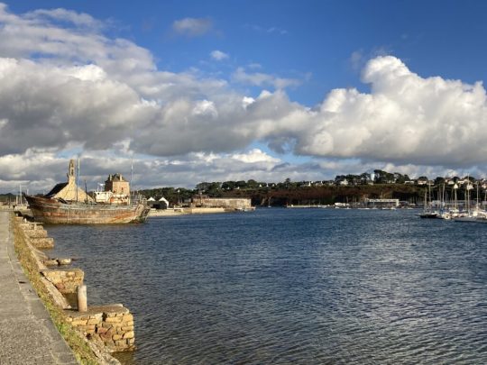
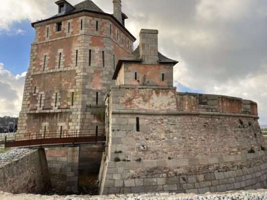


Leider ist der Turm geschlossen, aber die kleine Schiffskirche lädt mich zum Besuch.


Camaret sur-Mer ist eine der Überraschungen auf meiner Tour. Was als kleiner Umweg in Sachen Vauban gedacht war, erweist sich als Volltreffer. Diese Halbinsel ist so geschichtsträchtig wie fotogen.
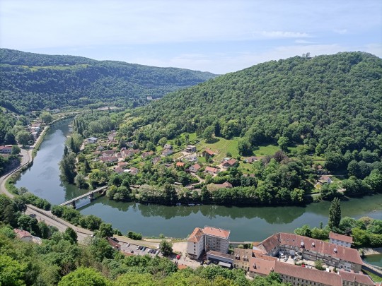
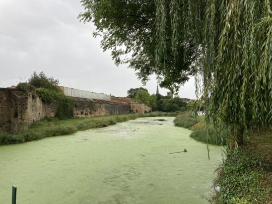
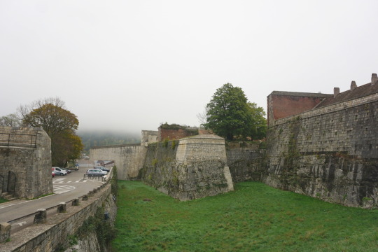
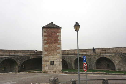
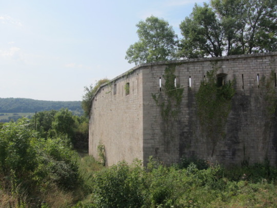
Besançon
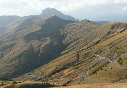
Fast am Ende meiner Rundreise besuche ich die Stadt Besançon, in der sich Vaubans schönste Zitadelle befindet.
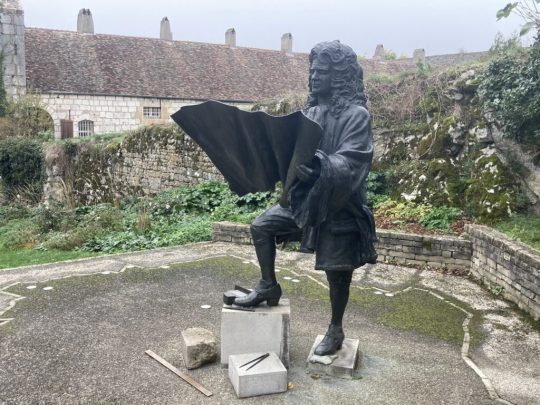
Besançon liegt im Tal zwischen zwei Bergen und ich möchte die Zitadelle eigentlich vom Fort de Chaudanne aus fotografieren, was leider ein dichter Nebel verhindert. Deshalb fahre ich durch schmalste steile Gassen im historischen Zentrum vorbei an der Kathedrale zur Zitadelle hinauf und stehe wenig später vor dem Denkmal für den großen Baumeister.


Das historische Stadtzentrum wäre zweifellos einen Besuch wert, doch schlechtes Wetter und fehlende Haltemöglichkeiten zwingen mich schneller als geplant den interessanten Ort zu verlassen. Dafür gibt es einen Stopp im Herbstwald am Fluss.

Resümee
Ich habe auf meiner Rundfahrt durch Frankreich Vertreter der Festungsanlagen besucht, die das Welterbe um den Militärbaumeister Sébastien Le Prestre de Vauban repräsentieren. Zum Glück sind sie aus heutigem Blick eher romantisch und hoffentlich nie mehr notwendig. Interessant war der Besuch allemal und besonders in Verbindung mit den Orten, in denen sich die Bauwerke befinden. Es lohnt sich auf jeden Fall, sich die nähere oder auch weitere Umgebung anzuschauen und Orte zu besuchen, an denen man ohne die Welterbestätte vielleicht vorbei gefahren wäre.
Dobbys Einrichtung und Ausstattung hat sich auch im Novemberwetter bewährt. Alle Details zum Ausbau meines Minicampers findet ihr hier: https://5-reisende.de/2022/07/29/55-000-km-on-the-road-vom-nordkapp-bis-sizilien-dobby-insights/. Meine Übernachtungsplätze habe ich wieder auf park4night gesucht und unter 5Reisende bewertet. Die App Toiletten Scout hat sich größtenteils nicht als hilfreich erwiesen.
Read the full article
#Abenteuermobil#Abenteuerreise#alleinunterwegs#Alleinreisen#Ausbau#Ausrüstung#Autoreise#Besançon#Besichtigung#Camaret-sur-Mer#Camping#Camping-Mobil#Dacia-Dokker#DIY#Dobby#Erfahrungsbericht#Erkundung#Europa#Frankreich#Hochdach-Kombi#Inspiration#Leichtbau#Minicamper#Parkplatz#Reisebericht#Reisefotografie#Reisetagebuch#Reiseziele#Roadtrip#Rundfahrt
0 notes
Text

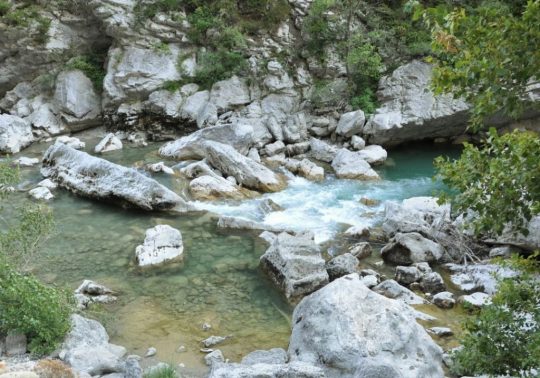
En bas de la photo, il y a le Doubs, à gauche duquel on peut voir une fortification. Sur la droite, on trouve des logements étudiants (dans le bâtiment en pierres) et La City, un dôme qui abrite des bureaux. Enfin, on distingue la colline Chaudanne au fond.
0 notes
Photo
Ecriture nocturne...Chaudanne. 2020
Photographie : Mj JOUVENCEL
Sony SDC 99Hx Mode S Iso 200 f/4,5 1/4 s
2 notes
·
View notes
Text
Top 12 Stunning Facts About The Verdon Gorge

One of the most fascinating canyons in the world was formed by a river that has cut itself through the limestone rock formation. The views are breathtaking and this remarkable natural landmark is a popular tourist destination in France.
In this article, you can explore some of the most fun and interesting facts about the Verdon Gorge, an incredible piece of nature that you simply have to put on your bucket list!
1. The canyon is located in the southeastern corner of France
The Verdon Gorge is one of the most fascinating natural features in southern France. This river canyon is situated in the southeastern corner of the country in the Provence-Alpes-Côte d'Azur region.
The major cities of Marseilles and Nice (to the southwest and southeast respectively) are just a 1-2 hour drive away, which means that the canyon is a very popular tourist attraction in the region.
The entire region of the canyon with all its natural beauty, including the canyon with its steep cliffs and captivating river, a wonderful lake, and multiple scenic hiking trails, is part of the Verdon Natural Regional Park.

The amazing canyon / Pixabay
2. It forms the natural border between 2 French Departments
The Provence-Alpes-Côte d'Azur Region is one of the 18 administrative regions that make up the country of France and is the utmost southeastern region in the country.
It pretty much encompasses the historical region of Provence in France and is world-famous for being the location of the "French Riviera," as well as the location of the yearly Cannes movie festival.
This region is made up of 6 departments of which the canyon partially forms the natural border between two of them. These are the Departments of Var to the south, and Alpes-de-Haute-Provence to the north.

The cliffs of the amazing canyon / Pixabay
3. It was formed by a remarkable river with the same name
The history of the canyon remarkably begins during the Triassic Period which lasted between 251.902 million and 201.36 million years ago. Back then, the entire Provence region was covered by the sea and large deposits of limestone were left here.
It wasn't until the Cretaceous period, between 150 and 66 million years ago, that the landmass of the area was raised and rivers were eventually formed that gradually cut through the landscape to form canyons.
One of the most prominent rivers in the area is the Verdon River, a stream that has cut through the limestone for millions of years, resulting in this amazing natural landmark!
The river is very distinctive because of its turquoise color (after which it was named). This effect is created by the deposits of the minerals of glacial flour, small particles of rock that turn the water into this amazing color.

The Verdon River flowing through the canyon / Pixabay
4. The source of the river is well-known by cycling fans
The Verdon River is one of the larger rivers in the southeastern part of France and has a total length of 166.5 kilometers (103.5 miles). This means that its source is relatively far away from Verdon Canyon.
If you're a cycling fan and regularly watch the Tour de France, the most important cycling event in the world, then you will surely have heard about the Col d'Allos, a narrow mountain pass often used during this event.
The source of the Verdon River is situated near the Col d'Allos. The river flows to the southwest, passes by various artificial lakes, and eventually drains in another major river in the region, the "Durance River," one of the most important tributaries of the "Rhône River," one of the major rivers in Europe.
Col d'Allos near the source of the Verdon River / Pixabay
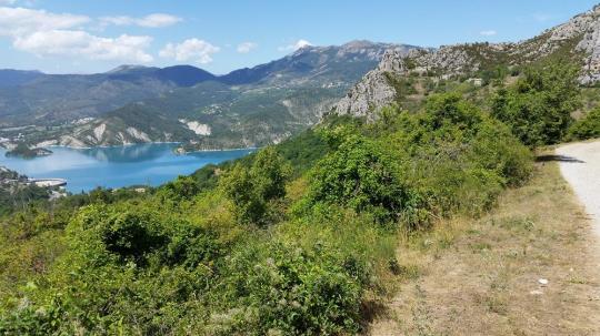
5. The Verdon River drains into an artificial lake near the canyon
One of the most amazing facts about the Verdon River is that its entrance is literally situated near the location that the Verdon River flows into the Lake of Sainte-Croix.
This is easily one of the most picturesque lakes in the region, mainly because it has the same turquoise color as the Verdon River!
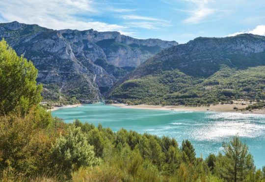
Lake of Sainte-Croix / Pixabay
6. The lake was formed by one of 5 dams in the area
The lake is a popular location for all sorts of water sports and was created during the construction of the "Dam of Sainte-Croix," one of 5 dams constructed in the region between 1929 and 1975.
The construction of the other important dams in the area also formed lakes, including the "Lac de Castillon" and the "Lac d'Esparron-Gréoux," as well as the "Reservoir at Chaudanne" and the "Reservoir at Quinson."
These artificial bodies of water really add to the overall charm of the region, that's for sure!

The lake and entrance to the gorge / Pixabay
7. An entire village was moved higher for the dam's construction
In order to construct these dams, several villages had to be flooded. In case of the Lac du Sainte-Croix, this village is called "Les Salles-sur-Verdon."
When you travel to the Verdon Gorge from the south, you will pass by this village which is situated just a few minutes away from the mouth of the canyon at the lake.
This means that the original village, which is situated at the bottom of the lake, was completely rebuilt at a higher location, creating this magnificent sight.
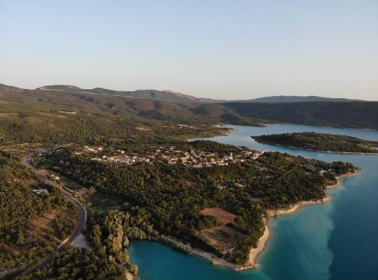
Les Salles-sur-Verdon / Olivier Cleynen / https://creativecommons.org/licenses/by/4.0/deed.en
8. The canyon is relatively long and incredible deep in some areas
So how long and deep is the Verdon Gorge?
The canyon is situated between two villages in the area, Castellane and Moustiers-Sainte-Marie. It has a total length of approximately 25 kilometers (15.5 miles).
Millions of years of the river cutting through the relatively soft limestone also made this canyon extremely deep, with a maximum depth of about 700 meters (2,300 feet).
The overall depth of the canyon is anywhere between 250 and 700 meters (820 to 2,300 feet) and the width ranges from 6 to 100 meters (19 to 328 feet) at the ground level. This means it's extremely narrow at some points as well.

View of the long and deep canyon / Pixabay
9. The river disappears underground at some point in the gorge
One of the most remarkable facts about the Verdon Gorge is that some parts of the Verdon River suddenly disappear underground, only to remerge from the enormous underground rock formations a bit further.
This part of the canyon is referred to as the "Styx du Verdon," a reference to the river Styx. In Greek Mythology, the river Styx forms the boundary between Earth and the underworld, which is kinda what literally happens to the Verdon River in the canyon.
Detail of the river inside the canyon / Pixabay
10. There are multiple scenic hiking trails near the canyon
One of the best ways to explore the region is to follow one of the multiple popular hiking trails. This allows you to explore the entire canyon through narrow passages, steep climbs, tunnels, and exciting footbridges.
The most popular hiking trail is called the "Sentier Blanc-Martel" and takes hikers about 12 kilometers (8 miles) all across this wonderful piece of nature!
This trail was named after explorer Édouard-Alfred Martel (1859-1938), a man often referred to as the "Father of modern Speleology."
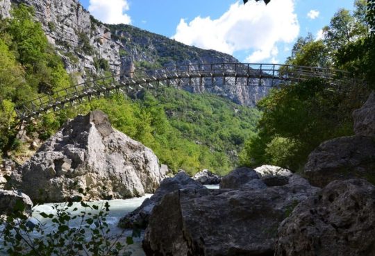
Bridge across the canyon for hikers / Pixabay
11. The limestone rocks are heaven for rock climbers
Apart from being one of the most beautiful canyons in Europe, it's also one of the most popular locations for rock climbers. The gorge one of the best locations in the world for multi-pitch climbing, which means routes divided into several sections with resting stations in between.
There are over 1,500 routes available with pitches ranging from anywhere between 20 meters (65 feet) to over 400 meters (1,300 feet). This makes the cliffs of the Verdon Gorge the perfect location for climbers of any experience level as well!

One of the many cliffs that can be climbed / Pixabay
12. You don't have to be a rock climber to enjoy the region
The region is popular for a wide variety of adventurers as a wide range of outdoor activities and sports are conducted here. These include canoeing, paragliding, rafting, and canyoning!
Fishermen can also enjoy the canyon, especially those interested in fly fishing which can be done right inside the Verdon River.
Yes, this amazing spot is bustling with tourists during the holidays, and it's not hard to imagine why!

Canoeing on the Verdon River near the gorge / Pixabay
Read the full article
0 notes
Text
It's a dream! 30 building plots as package, only 1:40 from Nice Airport.
https://aiximmo.ch/en/listing/its-a-dream-30-building-plots-as-package-only-140-from-nice-airport/
Construction land with building permissions in a quit location close to the lakes Lac de chaudanne and Lac de Castillon...
#Demandolx - #Mixed_Lot #frenchriviera #cotedazur #sainttropez #sttropez #nice #cannes #antibes #montecarlo #estate #luxe #provence #immobilier #luxury #france #monaco #realestates #immobilier #immobilien
0 notes
Text
WILSON COÊLHO: UM DIABO NO PARAÍSO
WILSON COÊLHO: UM DIABO NO PARAÍSO - Crítica literária de Gilbert Chaudanne
Nesse livro, NOSOTROS, Wilson Coêlho representa ou apresenta uma face diferente de tudo o que escreveu até agora. Seus livros tinham um caráter dionisíaco. Aqui é um pouco diferente, se trata de uma espécie de testemunha de sua viagem à Cuba; ele não é o que sai da boca de Wilson Coêlho (Deixem-me Falar), mas o próprio país (Cuba) e o autor faz um trabalho de pesquisador. Ele olha a realidade de…
View On WordPress
#óbvio ululante#Baía dos Porcos#Bloqueio Continental#Bloqueio Econônico#Brasil#Che Guevara#Consumismo#Crítica Literária#Cuba#Editora Cousa#Ernesto Che Guevara#EUA#Europa#Fidel Castro#GILBERT CHAUDANNE#Ilha#Ilha de Cuba#Joyce#Nelson Rodrigues#Nosotros#Paraíso#Pobreza#Praia dos Porcos#Revolução de 1848#Tio Sam#Trotsky#URSS#USA#Verlaine#viagem
0 notes
Text
conseil recrutement ressources humaines Besançon
Green Search, conseil recrutement ressources humaines Besançon par approche directe et executive search, est basé dans une flopée de villes en France.
Notre cabinet dispose d’une offre de services complète pour les entreprises et les candidats.
Green Search, conseil recrutement ressources humaines Besançon
conseil recrutement ressources humaines à Besançon pour les entreprises : Notre savoir-faire des méthodologies de recrutement par annonce et notre savoir-faire en tant que conseil recrutement ressources humaines à Besançon nous permettent de mettre en œuvre une stratégie de recherche parfaitement ciblée.
En tant que conseil recrutement ressources humaines à Besançon, nous avons des relations privilégiées avec les dirigeants des entreprises Françaises dans tous les secteurs d'activité.
conseil recrutement ressources humaines à Besançon pour les candidats : Nous apportons aux demandeurs d'emploi toute notre savoir et nos conseils pour mieux appréhender leur carrière. Sur notre site partenaire, nous proposons de nombreuses offres d'emploi à Besançon et sur toute la France dans tous les secteurs d'activité. Sur le site emploi, les candidats ont également la possibilité de déposer leur CV, de s'inscrire aux alertes et d'avoir accès à de nombreux conseils dans le cadre de leur recherche d'emploi à Besançon
Vous souhaitez nous contacter ?
La ville de Besançon jouit d’une situation privilégiée sur l’axe structurant européen dit « Rhin-Rhône », voie de communication entre mer du Nord et Méditerranée, l'Europe du Nord et l'Europe du Sud. Elle est située plus précisément à la jonction de la région montagneuse d’élevage du massif du Jura et des vastes plaines cultivables fertiles franc-comtoises. La ville est placée sur le front externe du massif jurassien, dans la zone des faisceaux externes ; Besançon étant situé entre deux faisceaux, les faisceaux des Avant-Monts au nord et le faisceau bisontin au sud,,.Elle se trouve dans la pointe nord-ouest du département du Doubs, dans la vallée du Doubs. Elle est distante d’environ 90 kilomètres de Dijon en Bourgogne, de Lausanne en Suisse et de Belfort aux portes de l’Alsace et de l’Allemagne. Sa distance avec la capitale nationale, Paris, est de 327 kilomètres à vol d’oiseau pour un cap de 304°. Il est à remarquer également que Besançon se situe presque exactement au milieu d’un segment Lyon - Strasbourg, chacune de ces villes étant distante de 190 kilomètres environ.La ville de Besançon s’inscrit également dans un site géographique naturel particulièrement remarquable. En effet, la cité s’est d’abord développée dans un important méandre du Doubs de près d’un kilomètre de diamètre, prenant la forme d’une boucle presque parfaite fermée et surplombée par le mont Saint-Étienne, une section du faisceau bisontin abrupt du côté de la ville, dont la pointe est intégralement coiffée de l’imposante citadelle de Vauban. Puis la ville a débordé de ce cadre initial (d’une altitude moyenne de 250 mètres) pour s’étendre dans une cuvette entourée de sept collines dont la plupart est coiffée de forts : Chaudanne (422 m), Bregille (458 m), Saint-Étienne (371 m), la Roche d’Or (316 m), Planoise (490 m), Rosemont (466 m), Fort-Benoit (360 m). Le point culminant de la commune de 620 m est situé au fort de Chailluz (dit aussi fort de la Dame Blanche), sur la crête des Avant-Monts. Cette configuration amène parfois à faire la comparaison avec le site de la ville de Rome qui est également dominée par sept collines.Ce site particulier a donc pendant longtemps constitué un emplacement idéal de développement urbain, tant d’un point de vue stratégique et militaire (site défensif) qu’économique et commercial (débouché fluvial, forêts, agriculture et élevage).Le centre historique, correspondant au quartier installé à l’intérieur du méandre du Doubs, dit quartier de la Boucle, et au quartier de Battant, première excroissance historique sur l’autre rive, constitue le site exclusif (ou site primitif) de développement de la ville jusqu’à la révolution industrielle.
Read the full article
0 notes
Text
Méribel-- The Gem Of Les Trois Vallées Ski Location
Méribel, situated at the heart of Les Trois Vallées, the world’s greatest ski location, is the ideal location to make that dream come real. Méribel’s resorts have actually been constructed particularly for skiers and are interlinked with all other resorts in Les Trois Vallées, so that one pass supplies access to over 180 ski lifts and more than 600 km of ski runs-- as well as 120 km of cross-country tracks.
Méribel is among the world’s excellent cosmopolitan ski resorts
Established in 1938, Méribel is now one of the world’s excellent cosmopolitan ski resorts. Positioned in between 1450 and 1700 metres above sea level, the primary town of Méribel has genuine Alpine beauty, with genuine chalets constructed of wood and stone.
A range of wonderful snow sport alternatives
The resort likewise has lots of snowboarding and snowboarding schools for any ages and abilities, plus non-ski kindergartens and créches that are open daily. The night life is vibrant and the bars and dining establishments in the town centre are fairly priced-- attempt the Platin or the Plein Soleil for a tasty meal. There are likewise a lot of stores, grocery stores, trip centres, a mobile house park, banks, a post workplace, and obviously all sort of lodging.
With over 70 groomed runs, Méribel caters for skiers and snowboarders at every level of proficiency. Méribel’s likewise has 685 snow cannon and 25 grooming devices that go to work as quickly as the runs are closed to guarantee your next day’s snowboarding is the finest possible.
Not just snowboarding
If you ‘d rather walk, the Méribel Valley provides over 25 km of groomed strolling routes, even throughout the winter season, and you do not require snowshoes or unique devices to enjoy them. The routes link the turn to the regional towns along with a few of the mountain dining establishments, and you can likewise sign up with a group for a directed snowshoe walk the valley.
Méribel’s ski season ranges from early December to late April, however the location is lovely throughout the year. Simply take a train to Moutiers, then a bus or taxi to Méribel, and enjoy your remain in the ‘gem’ of Les Trois Vallées.
As soon as you’ve had adequate snowboarding, you can attempt the indoor pool and the climbing up wall at the Olympic centre, located near the Chaudanne lifts. The resort likewise has an ice-skating rink, bowling street, physical fitness centres, movie theaters, and centers for snowshoeing, parasailing, hang-gliding, plus hot air balloon flights.
0 notes
Text
Besançon
Photo ©mikaeldemenge
#besancon#doubs#besac#riviere#landscape#cityscape#franche-comte#la nature dans la ville#river#besancontourisme#besanconmaville#besanconboosterdebonheur#besanconphoto#cacestbesac#ville#vauban#citadelle#chaudanne#chamars#bastion#fortifications#town
57 notes
·
View notes
Text
Le lac de Chaudanne
Le lac de Chaudanne constitue un des joyaux du Parc Naturel Régional du Verdon.
par Tourisme en photos : Provence Mer Montagne http://www.photos-provence.fr/tourisme-paca/lac-de-chaudanne.html
0 notes
Text
Top 5 ski resorts in the Alps
There are more ski resorts in the Alps than you could shake a stick at. It would probably take a lifetime to visit them all. If you’re a regular visitor to the Alps and you love to ski, then you’ll probably already have your favourite resort and perhaps you’ll return there year after year. Nothing wrong with that. After all, you’ve probably fallen in love with the place of your choice and it delivers every year, so why not stay with the tried and tested. However, you never know, you might make a change to one of the below resorts and wonder what you’ve been missing.
Zermatt
As Switzerland’s premier resort, Zermatt attracts visitors all year around, the skiing ranks amongst the very best to be found in the Alps. However skiing isn’t the only thing that Zermatt offers its visitors. The hills are alive with the sound of walkers and mountain bikers, while the colourful canopies of Paragliders swoop and glide overhead. The summer months affords the opportunity to enjoy the lush forests and Alpine pastures that rise up from the village to dizzying heights.
Zermatt lies in the Matter valley in South-Western Switzerland, part of the Pennine Alps. At 1,620m Zermatt is the highest town in the valley, and though famed for the iconic Matterhorn mountain surprisingly this is not the highest peak in the valley. Zermatt is surrounded by 38 summits over 4,000m.
Zermatt was part of a farming valley and in the area next to the Grand Hotel Zermatterhof several old buildings show the traditional building style of the original Walser residents. Some of the old barns and grain stores in the resort are up to 500 years old. Today, Zermatt is formed of several small farming hamlets which have gradually spread to become one town, housing its unique collection of classically Swiss hotels, and it’s modern, super deluxe collection of chalets.
At the northern side of Zermatt sits the exclusive ‘Petite Village’ with its collection of stunning chalets all lit by night to produce a fairytale scene. These chalets dot the mountain flank above Zermatt giving stunning views of the whole valley and village below. Petite Village is a premium location boasting premium chalets.
Central Zermatt hosts a collection of hotels and some exceptional chalets that hug the river Vispa, which bisects the town. Church Square is the hub for most town events, including the New Year’s Eve fireworks display, and there are some fabulous restaurants nearby.
As a car free town, one of Zermatt’s unique sights are the electric taxis and buses which transport both skiers and pedestrians from one sector of town to another, allowing you to explore the full area wherever you choose to stay. For the romantics among us there are also horse drawn carriages and sleighs.
Verbier
Visitors flock to Verbier from all over the world for the authentic Swiss charm, beautiful traditional ski chalets and the vibrant and buzzing town. Verbier plays host to some amazing international events year round including overnight mountaineering and ski touring races, the Ski Alpinism World Cup event and an International Show Jumping Grand Prix. A truly international and glamorous ski destination.
Verbier is located in southwestern Switzerland in the canton of Valais. Lying on a south oriented terrace at around 1,500 metres and facing the Grand Combin massif; the resort benefits from the south-facing vista with some glorious sunny days on the mountain. Famous for its off-piste; with the surrounding peaks full of impressive chutes, gullies and couloirs it has some of the most challenging terrain in the Alps.
From Verbier’s high point at the top of Mont Fort (3330m) you are treated to panoramic views across the Alps including the Matterhorn, Dom, Dent Blanche, Dent d’Hérens, Grand Combin and the Mont Blanc massif. As part of the Four Valleys ski domain you can ski Verbier, Nendaz, Veysonnaz, La Tzoumaz and Thyon under the one lift pass, with over 410 km of marked pistes.
As with most Alpine ski resorts Verbier was originally a farming hamlet; when the first recorded attempt at skiing in Verbier took place in 1925 the companions would have been cows and herdsmen who must have thought it a strange site. It wasn’t until 1946 that the first lift system was installed, but it was the snow sport boom of the 1960s that began to transform this small farming village into the world leading ski resort that it is today. Verbier has a number of fascinating museums and galleries that are well worth visiting and display the journey that Verbier has taken from farming hamlet to international ski destination.
Today accommodation in Verbier consists predominantly of traditional Swiss-styled chalets, but there are also a number of outstanding international hotels here including the stylish W Hotel, which opened its doors in 2013.
Meribel
Méribel lies in the Les Allues Valley at the centre of the world’s
largest linked ski area, les Trois Vallées, giving access to over 600km of piste and unlimited off-piste. Owing to it’s enviable position at the centre of les Trois Vallées, Méribel is the perfect base from which to explore the extensive skiing on offer. Val Thorens, the highest skiing in the area at 2,300m, can be reached on skis in under an hour, and Courchevel is even closer. As well as the two main resorts, Méribel and Méribel- Mottaret, the valley also includes a number of villages. Together they form one of the most popular destinations for British skiers (the resort was, in fact, founded by a British Colonel, Peter Lindsay, in 1938).
The resort’s perennial popularity is due not only to its extensive skiing, but also to the attractive traditional Savoyard-style architecture. Unlike many purpose-built ski resorts Méribel has retained its alpine charm and consists entirely of chalet-style wood and stone buildings. As the largest of the villages in the valley Méribel has plenty more than its skiing on offer; the ice rink regularly hosts national and international ice hockey matches, and there is an indoor swimming pool, a bowling alley, and plenty of shopping on offer. The whole area sits on the edge of the Vanoise National Park making for truly stunning scenery for walking and snowshoeing.
At the top of the valley, about 4 km from Méribel, is Mottaret (1700 to 1800m). This village was developed in the early 1970’s and therefore has a more modern (but still attractive) look. It is quieter than Méribel, but still has a good selection of shops and bars, and the added bonus of lots of ski-in /ski out accommodation. Méribel-Village lies at 1400m and is approximately 2 km from Méribel on the road to La Tania and Courchevel. This tiny hamlet provides peaceful accommodation; making it popular with families and beginners and has a supermarket, an excellent boulangerie, a lively bar for après and a couple of restaurants. It has its own chair lift that runs up to the Altiport area (which is good for beginners.
Les Allues is a charming village at 1100m that has a more traditional feel to it.
The village is served by the Olympe gondola that whisks you up to the Chaudanne in the heart of Méribel’s ski area. Les Allues has a supermarket, ski hire shop and several restaurants. If you want to head up to Méribel, there is a public bus service – the journey time is around 15 – 20 minutes, alternatively you can take the gondola lift or you can easily hire a local taxi.
Val d’Isere
Arguably the most iconic of the French Alpine resorts, Val d’Isère has a lively and vibrant ambience, and carries itself well as one of Europe’s top ski destinations, with a fearsome reputation for its challenging black pistes and off-piste itineraries, and its buzzing après ski scene. Val d’Isère lies at the far end of the steep Isère Valley, at the farthest end of the larger Tarentaise Valley region where you will find the biggest concentration of world class ski resorts in the world. Of these Tarentaise super-resorts Val d’Isère more than holds its own. Alpine skiing began here in the 1930s, and was later linked into the neighbouring ski resort of Tignes, to form the extensive Espace Killy ski domain.
Less than 5 km from the border of Italy, and on the border of the Vanoise National Park Val d’Isère is for the most part now a traditional-looking alpine village, nestled between the famously steep sides of the Isère Valley. Historically a small farming hamlet just providing accommodation for farmers grazing their animals on the high alpine pastures, the village developed first into a summer destination, before winter sports enthusiasts encouraged the development of the ski resort we know today.
The first major lift, a cable car to the Solaise, was even built during the Second World War, and after the war ended the resort really took off, including the opening up of the Glacier for summer skiing.
In the 1960s the resort’s architecture took a turn for the worse with high-rise buildings and apartment blocks. Luckily thanks largely to the 1992 Albertville Olympics bringing the men’s downhill events to Val d’Isère improvements were made to the look of the resort, and many of the high rise buildings were slowly changed into buildings reflecting traditional design and using local materials, leaving us with the pretty resort we know today.
In addition to the ‘beautification’ of the resort carried out in the run up to the 1992 Olympics there is also now a strictly-enforced no parking policy in the town centre; roads are left snow covered and mature trees line the route where cars once parked, much improving the winter wonderland feel of the resort. The iconic church of Saint Bernard de Menthonwas built in 1664 and is undoubtedly the most charming feature of the resort, forming a central focal point around which the town has developed.
Le Fornet is a beautiful and quaint hamlet, just 5 km to the east of Val d’Isère. The architecture here is particularly appealing – traditional Savoyard stone and wood designs and not a high rise in sight. The beautiful River Isère bisects the hamlet, with an ancient stone bridge crossing, very picturesque, but also practical. In summer this area marks the start of the Col d’Iseran; snow covered and inaccessible in winter it opens up some of the Espace Killy’s best off-piste skiing. Traditionally quieter than central Val d’Isère with only a handful of (chic) chalets, the access to the skiing is often less crowded at the start of the day, meaning less queuing of course. Just above Le Fornet lies the Glacier du Pisaillas, at 3,400m it offers summer skiing, and ensures excellent conditions in winter.
At the far western side of town lies the hamlet of La Daille; constructed in the 1960s, accommodation was purpose-built to house the growing numbers of winter clients, now flooding to the resort, which had firmly established a reputation for being one of the finest ski resorts in the Alps. Although there are a number of large apartment blocks here, the area also houses a couple of the resort’s most spectacular chalets, and a rather nice restaurant, the Edelweiss. The skiing access here as you would expect is superb, with the ‘Funival’ funicular taking skiers to the start of the infamous men’s downhill track ‘Le Face’, but also accessing the linking runs and lifts across to the neighbouring resort of Tignes.
St Anton
St Anton is a legendary Austrian ski resort in the South Tyrolean Alps, boasting both fantastic skiing and its own infamous brand of après ski. It was an early starter in terms of winter Alpinism; the first skiing in the Arlberg regions was actually recorded in 1895 when the parish priest of Lech made a first attempt at skiing – to the ridicule of his parishioners. Despite their obvious amusement the sport steadily grew, and on 3rd January 1901 a group of friends together formed the Arlberg Ski Club – which still exists today. They held their first internal races in 1903, and since have hosted many international racing competitions including several Alpine Skiing World Championships – the most recent in 2001.
The skiing in St Anton & the Arlberg region peaks at 2,811m, and the resort offers a skiable range of 1,507 m, with St Anton village itself sitting at 1,300m. The resort is fast becoming one of the most popular in Europe, and for good reason; it has an excellent snow record, sits within a two-hour drive of three major international airports, and has a train station if you prefer to travel by rail. Easily accessible, and retaining a cosy, village atmosphere, St Anton is known for being incredibly warm and welcoming.
It is also the home of modern Alpine skiing, as the birthplace of Johann ‘Hannes’ Schneider, who invented the ‘Arlberg Technique’ of downhill skiing and tuition. He was the first to pioneer the stages of instruction from snowplough to parallel turns that is still taught today. Schneider himself was self-taught, crafting his own makeshift skis as a child from a sledge maker’s scraps and a sieve nailed on to the runners as a binding. He often practised by moonlight to avoid the laughter of friends and family.
St Anton remains an innovator, with spectacular new lifts such as the pioneering Galzig gondola, which uses Ferris wheel technology to allow visitors to enter the lift at ground level. It is also a member of the USA Epic Pass scheme, which allows holders of season passes in many of the USA’s major resorts (including Vail, Breckenridge, Beaver Creek & Heavenly) to spend 5 days skiing in St Anton, included on their lift pass. Likewise holders of an Arlberg season pass can return the favour by visiting each of the US resorts for up to 5 days. Fantastic, and sure to recommend St Anton to a whole new crowd of skiers from the USA, not forgetting Perisher in Australia, which is also a member of the scheme.
The layout of St Anton has of course changed over the years with the resort’s continued development, but it has retained the village feel and has avoided the pitfalls of over-development. The village sits in the valley with steep mountains either side, and the beautiful Rosanna River running through the middle. The centre of the village is also pedestrianised, and the main street ‘Dorfstrasse’ is often snow covered, with many of the resort’s hotels, bars and restaurants spilling off it. Many of these are still the original, timber-clad buildings and contribute to the unique ambiance of St Anton, as does the church with its ‘onion dome’ roof, dating back to the 17th century.
Accommodation in St Anton is still predominantly located in the centre of the village, however prime location is certainly to be close to the Galzig gondola if you want to catch that first lift. That said, taking a chalet a little further out will offer you more space and privacy, and with the chauffeur service included you will not miss out on that first lift – but be transported to it in total comfort and warmth, avoiding any un-necessary walking in ski boots. Taking this into consideration Nasserein opens itself up as an excellent location; previously its own little hamlet it has now ‘merged’ with St Anton, and is home to the nursery slopes so a great spot with small children just beginning to learn.
While there is a wide variety of skiing available to skiers of all levels, St Anton is perhaps best for intermediate and advanced skiers; from the nursery slopes at the bottom it is quite a step up to the blue pistes further up the mountain. The blue runs here are known to be tricky, the reds tougher still. It is however perfect for enthusiastic intermediates looking to improve their technique and relish the challenge, and experienced skiers will have lots to keep them interested with steep reds and blacks, and challenging off-piste itineraries, especially in the Valluga area.
Danny Frith is Director at SkiBoutique. SkiBoutique is a luxury ski chalet agency based in Switzerland.
If you would like to be a guest blogger on A Luxury Travel Blog in order to raise your profile, please contact us.
The post Top 5 ski resorts in the Alps appeared first on Tripstations.
from Tripstations http://bit.ly/2RfPXHf
via IFTTT
0 notes
Link
via L'essentiel de l'information - macommune.info
0 notes
Photo
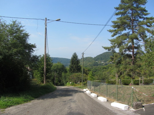


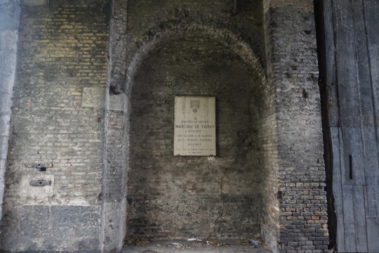
Besancon. France - 24.08.2017: Besancon, Fort de Chaudanne (Esplanade de la 3e division d´Infanterie américaine 1944),
0 notes
Text
Charpente Monard
Charpente Monard, ZI CHAUDANNES à Albens, Tél 04 79 54 13 57 avec Itinéraire.
Source : http://bit.ly/2zUJ4kk
0 notes
Last Seen Blogs

morrisfirmlaw
The Morris Firm

postsbygem-blog
PostsbyGem

strangelord
de piratas espaciales y hechiceros supremos

kmkk
kkmkk