#this includes wind gusts up to 50 mph
Text
Weather be like: all of the above

#darsy twirls the two hour delay#this includes wind gusts up to 50 mph#my whole half of the country is in weather shambles lol
4 notes
·
View notes
Text
Come Over

Pairing: Jake Kiszka X f!reader
Word Count: 4.2k
Warnings: the fluffiest of smut 🥹 soft!jake, unprotected sex, fingering/oral (f receiving), 18+ minors DNI!
A/N: ok i don’t usually write soft jake but i had to for my baby girl @gretavanbear. I listened to this song on repeat as i wrote this. i highly suggest tuning in! (just listen to the lyrics ok) i hope y’all like it :’)
“A Storm Weather Advisory has been issued along and north of I-78. Wind will also be a factor Wednesday, with gusts of up to 50 mph along the coast, and 30-35 mph inland.”
The voice of the woman reporting the weather forecast on your TV echoes in the background as you fold your laundry in the living room, on the phone with your best friend.
The two of you spent most nights on the phone, listening to each other carrying out mundane tasks. Just appreciating the other’s presence on the opposite side of the phone.
“Hear that, Jake?” You call over to your phone laying on the couch.
“What?” He responds.
“Gonna be a storm tonight they’re saying. Looks like it’s gonna be a bad one.” You warn him.
“Hmm, you’ll be alright.”
You and Jake had been graced with the most beautiful friendship since the 7th grade. Now in your 20s, he’s still your “go-to” for everything. The first person you call after receiving good news, the one you base your weekend plans around. The last thought on your mind before you go to bed, still taking up your thoughts the second you open your eyes in the morning.
He knew everything about you. Including your ridiculous fear of thunder and lightning. Ever since you were a kid, the sound of the thunder nearing closer, shaking the walls of your house. It was your own personal nightmare.
There was one thing Jake was unaware of about you. Something you weren’t even sure of yourself. Your entire friendship with Jake had been just that… friends. But there was a certain feeling you experienced in the pit of your stomach everytime your eyes landed on him as you met up. That first glance at him as he approached you, whether it be over dinner or picking you up to go on a drive and listen to the new music he discovered that week.
Deny. Deny. Deny.
You had watched him go through girl after girl. Years of listening to him tell you the quirks about the girl of the week, just to watch him with another one the following weekend. For some reason, it didn’t affect you as much as you’d expected. You’d known nothing else but friendship with Jake. Your denial of the true feelings you had for him had taken over your brain. Pushing the thoughts so far back, you pretended they never existed in the first place.
“Where are you going?” You asked him with a smirk on your face. Figuring he’d have plans with someone tonight. He always had plans.
“Huh?” His voice sounded far away from the phone.
“It sounds like you’re in the car. Going somewhere?” You prodded.
“Oh. Just driving. Not much going on tonight.”
Jake lived about 35 minutes from your apartment. Neither of you cared about taking the drive. The times you drove to Jake’s place felt like 5 minutes in the car. But the trek home felt like 5 hours. Back to your apartment. Where you lived alone, the scent of him still lingering on your clothes. Sometimes you’d lay in bed and catch yourself inhaling his aroma on your sweater from when he hugged you goodbye.
And there it was. The first crack of thunder. You’d remember from middle school someone telling you if you counted how many seconds between the flash of lightning and the rumble of thunder, that’s how many miles away the storm was. Whether that was true or not, who knows.
It had been drizzling the entirety of the time you had been on the phone with Jake. As you carried your basket of clean folded clothes to your bedroom, you rested your phone on top, Jake listening on the other side.
You began to take the clothes out of the basket and place them in their known spots in your room. This one goes in the bottom drawer. This one is meant to be hung on a hanger in the closet.
There was one window in your bedroom. You always kept the blinds up, enjoying the sunlight that washed over your space in the morning. The rain began to smack against the side of your window, followed by a strong howl of wind causing the tree outside to brush up against your apartment building.
Distracting yourself with laundry was the best way to avoid the anxiety that started to creep up in your stomach as you heard the storm coming undone outside.
You pulled out the top drawer of your dresser and began to place your underwear and socks in their correct spots, always priding yourself for your organization skills.
Complete darkness. Accompanied by the sound of every electronic device in your house powering down.
“Shit. Jake?” You called for him.
“Yeah?” You heard the engine of his car revving in the background.
“My fucking power just went out. Fuck!” Grabbing your phone to turn on the flashlight, you scurried around your room. Finding your lighter and beginning to bring a flame to every candle you could find.
He didn’t respond.
You checked your phone to make sure you still had service.
4 bars.
“Hello? Jake, can you hear me?” Your voice had a whine to it. You hated being alone, especially during a blackout from the storm.
You jumped out of your skin as you heard a knock at your door.
“Jake, please answer me. There’s someone at my door now!” You rushed down the hall to peek around the corner, trying your best to see who was there at this time of night in this weather.
“Just come to the door please.” The sound of pouring rain muffled his voice on the phone.
You felt the smile spread across your face at the sound of his voice confirming he was at your front door.
Unlocking the door, you swing it open to him. Your arms immediately reaching out to welcome his embrace.
“Jake! You came…” you didn’t care if he was soaking wet, nuzzling your face against his chest. He was just what you needed right now to bring you back down to earth, away from your worries.
“You called.” He smoothed the hair on the back of your head.
“I’ve been heading your way since you caught on to the fact I was in the car.” He broke away from the embrace, looking down at you with a warm smile.
You blushed to yourself, giving him a quick laugh under your breath, avoiding his eyes. Why were you nervous right now? He’s your best friend.
“Thank you, Jake. I mean it. I really appreciate you being with me right now. You know how I get wi-“ you were rambling on.
“The storm. I know.” As if he could read your mind.
“Yeah..” you trailed off. Slightly embarrassed of your juvenile fear.
“Got another lighter? I’ll help.” He followed you to the kitchen as you searched your drawers.
You handed him the white BIC lighter. He scanned it in his hand.
“Aren’t these bad luck?” He said with a laugh.
“I don’t even care at this point. I just don’t want to be in the dark anymore.” You whined to him.
“24 years old and she’s still scared of the dark.” He teased.
You rolled your eyes at him even though he couldn’t see it.
On your tippy toes, you tried your best to reach for the final candle that sat atop your kitchen cabinets. In the darkness, you heard his footsteps approach from behind.
“Here, I got it.” His back pressed against yours as he reached for the white candle above.
As he held it in front of the two of you to light it, you caught a glimpse of his face behind the flame. His brows furrowed in concentration as he tried to get the flame to catch the wick.
His eyes lifted to yours, a smirk beginning to form on his face as he caught you already looking at him.
“What?” His voice came out as a chuckle.
The candle was lit, and he placed it on the counter top.
“Nothing… I-“ you tucked your hair behind your ear, a nervous habit of yours that of course Jake was aware of.
“Spit it out then.” He egged you on.
“I just really appreciate you coming here.” Your voice whispered soft, a hint of nerves behind them.
With his back pressed against the counter top, he pushed off of it to step closer to you.
The darkness of your lifeless apartment was accompanied by the warm glow of every candle you owned. The golden light reflecting off each of your features.
As he stepped closer to you, he grabbed your arm at your elbow.
“I care about you.” His voice was raspy but soft at the same time. The sound of it traveling through your ears caused you to melt each time.
He took another step. Now toe to toe with you in the middle of your kitchen.
You could feel your heartbeat thumping in your ears.
“I know.” You replied to him, trying your hardest not to show how bad your nerves were affecting you right now.
“I don’t think you do.” His hand was rubbing against the skin of your arm, goosebumps following his touch.
You tilted your head at him in confusion.
His eyes fell to the floor as he continued to rub against your arm, inhaling deeply and blowing the air out of his mouth.
“I care about you. A lot.” He finally replies, eyes meeting yours again.
“I care about you too, Jake. A lot.” Your teeth shone through your wide smile as you locked your gaze with him.
The pad of his thumb found your jawline and traced the outline of it. Your knees felt as if they were going to give out. You watched his face as his eyes were trained on where his skin met yours.
“Can I show you?” He whispered to you, eyes flicking back to meet yours.
“Show me what, Jake?” You questioned him, unable to read his thoughts.
He leaned closer to you. His forehead pressing against you. His nose slotted next to yours. You worried he would be able to hear your quick breathing.
“Let me show you how much I care about you.” He pinched your chin with his thumb and pointer finger, tilting your head up to him.
It felt as if time had frozen. In this moment; here you were. Your best friend of years a breath away from your lips.
His lips were parted and the bottom of his teeth peeked through.
You watched his lips until you couldn’t anymore. Your gaze interrupted by the plush feeling of his mouth pressed to yours. He kissed you soft and sweet. His hand leaving your jawline only to replace his touch to your cheek. He cupped the side of your face as if to hold you against him forever. He never wanted this moment to end.
The butterflies in your stomach were so powerful they almost hurt. Your mind had turned to mush, lost to your entire being surrounded by Jake.
You felt him. You smelled his deep cologne. You heard his lips smack against yours.
From the grip he had on your cheek, you knew he wanted more, but was afraid to step any further.
You answered his silent pleas, slightly parting your lips to invite his tongue inside.
He lightly touched the tip of your tongue with his. You answered his call by sliding yours against the flat of his tongue. You felt his quiet moans travel into your mouth and down your throat.
His hand left its placement on your cheek to find your hip. He tightened his grip around you, squeezing the skin above your bone.
The kiss deepened. Mouths open wider. Lips slick and swollen.
A song from your phone, on repeat since Jake got there, faintly played in the background of the noises of your lips meeting together.
“Lover you should’ve come over. Cause it’s not too late”
You picked up on the lyric and huffed a breath of laughter in between kisses.
He parted his lips from yours and pressed his forehead against you, catching his breath. Your eyes scanned over his features before you grasped his fingers and led him down the hall to your room.
The heels of his boots clicked as he followed you down the hardwood floor.
You entered the room first. He swiftly wrapped you in his arms, turning to press you against the bedroom door, shutting it with a click.
You embraced his weight pushing you against the door as he continued the kiss with an open mouth. Inhaling sharply and exhaling out of his nose against your cheek.
Your fingertips grazed along his chest. Following down the buttons of his shirt until you reached the hem of it. You tucked both of your fingers into the waistband of his jeans, dipping past underneath his underwear, feeling his warm skin against your icy finger tips. He inhaled sharply through gritted teeth at your cold touch.
Your fingers ran along the band of his briefs until they met in the middle to reach the button of his jeans. His hips bucked towards your touch as you poked the button through the hole and began to pull his zipper down.
“Wait.” He broke the kiss from you.
“I- I’m sorry did I-“ you were embarrassed thinking you went too far.
“Before we do this. I need to be honest with you.” You felt his stare burn into your eyes, petrified at what was to come next.
You nodded at him, begging him to continue with his thoughts.
“If we do this…” he stroked the back of his hand against your cheek, “I can’t just be your friend anymore.”
You opened your mouth to respond but he cut you off.
“I think, I-“ he punctuated his sentence with a groan of frustration.
“Jake. Please, let me in. Whatever you’re about to say I can take it. If you don’t wan-“ he interrupted you once more.
“I’m in love with you.”
You felt as if the air had been stolen from your lungs. As if he’d punched you in the gut and kissed it better.
You started to feel a lump growing, burning in the back of your throat.
Before you could let the tears form, you grabbed the back of his neck, pulling him forward to meet his lips with yours once more. Kissing him with fervor, begging his tongue to visit yours again.
He guided you to the bed with his hands on your hips, placing you down softly once he realized the back of your legs hit the edge of the bed, never once breaking his lips from yours.
As your head hit the pillow, you tore away from him.
“I love you too, Jake. Always have.” You stared up at him with a gleam in your eye.
He brushed the hair from your face and responded.
“Always will.” You felt the smile on his lips as he kissed you again.
His fingertips began to trace the outline of your body, down your side to your hips.
“Let me be sweet to you. Show you how long I’ve felt this way.”
With your hand still wrapped around the back of his neck, you nodded up to him, signaling him to continue.
He smiled back at you in response. His body moving down away from you. You missed his lips already.
His face was so close to the skin of your tummy. You felt his hot breath against it as he moved.
He placed a single kiss to your hip bone before curling his fingers around the waistband of your sweat pants.
Before he did anything else, he looked up to you to ask for permission.
“May I?” A hint of smirk in his tone. He knew the answer to his question.
“Please” you whimpered back to him, the slightest buck of your hips towards him.
He slipped the pants down your legs, pulling them over your feet with the most gentle touch.
With the bottom half of your body bare, your nerves began to creep back in, clamping your legs shut.
“Relax for me.” His words were the remedy. You immediately felt the tension of your muscles relax, letting your legs fall to the side, spreading for him.
He glanced at your center, and if you weren’t staring intently you would have missed it as his eyes widened for a split second.
His soft lips kissed up the inside of your thigh. Inching slowly to where you needed him the most.
“You don’t understand…” he planted another kiss, so close, “how long I’ve dreamt of this.”
His words alone caused your hips to raise from the mattress, a strained moan breaking from you.
He could tell how bad you wanted his mouth, and he couldn’t wait to taste you either.
You felt his lips press gently against the skin above your clit.
He flattened his tongue to lick against your folds. Not yet licking them apart to taste your wet skin.
Your fingers tangled into his long brunette locks. Bunching them at the root.
Jake loved the feeling of you tugging at his hair. He dreamed of one day being able to feel that pleasure mixed with pain.
He pointed his tongue to lick through your folds. Finally feeling him against your heat. You sucked in a sharp breath and he rolled it over your clit.
He swirled his tongue around it, not exactly touching it but teasing.
You whined for him, pressing his face deeper into you.
“Please.” You breathed out.
He groaned against you, the vibrations of his gravelly voice sending a chill down your spine.
The tip of his tongue flicked over your sensitive bud, exactly where you craved him.
He flicked it over you again and again, each tightened grasp of your hand in his hair spurring him on.
He listened to your moans, dragging his middle finger down the side of your lower lips as he continued to lick against you.
You lifted your hips to meet him. The pad of his middle finger circled around your wet entrance.
He pushed the digit inside, retracting it slowly allowing you to feel every second of it.
He gave open mouthed kisses to your clit, curling his lips around you and sucking lightly.
He felt your walls clench around his finger, begging him to never leave from inside of you.
As he pulled his middle finger out, he added his ring finger next.
You felt the cold touch of the ring he was wearing press against your lower lips.
He rested his face against the inside of your thigh, extending his tongue to quickly lick against you as he pumped his fingers inside.
“Jake!” Your voice was strained. He could tell you were close. He wanted nothing more than to feel you come undone against his mouth.
“You are so beautiful.” He moaned against your wet skin.
He was gentle with you. Taking in every twitch of your thighs and every gasp of air.
He made love to you with his mouth, enjoying this just as much as you were.
You felt the rim of your entrance begin to quiver, that familiar warm feeling budding between your hips.
He looked up at you as he continued to lick you to climax.
The moment your eyes met his, you lost yourself to him.
Your body was tingling from your head to your feet. Your toes curling behind him.
You snapped your head back, pressing it harder into the pillow as you let your moans wail into the room.
He softly licked you through your orgasm. Grounding you back to earth with him.
He crept back towards you to meet your lips. Never rushing you, kissing you slowly to allow you to feel all of him against you.
“I’d taste you everyday if you’d let me.” He breathed into you between kisses.
With your mouth still on his, you tugged at his underwear, showing him you wanted them off.
He stood from the bed. Kicking his boots off, he then tugged his jeans past his hips before attending to his underwear. You caught a glimpse of the damp spot on his gray briefs from where he’d leaked with arousal onto them.
You groaned at the sight, pulling them down before he could even get his feet out of his jeans. He chuckled to himself at your needy actions.
With his bottom half now bare as well, he climbed back onto the bed with you, slotting between your legs, his knees pressing into the mattress.
His arms were stretched out straight, planted on either side of your head. He looked down at you. The necklaces he adorned swinging against his chest. The tips of his long hair tickled your cheeks.
A tight grin spread across his face.
For a second, you took him in. Realizing how gentle he was with you. Giving you pleasure first, never rushing a single second with you. Making you feel so safe.
You smiled to yourself at your own thoughts, reaching up to tuck his hair behind his ear, playing with the gold hoop he wore.
“I meant it.” You whispered to him.
He tilted his head in confusion.
You swept your thumb across his cheek and traced the outline of his lips.
“I love you, Jacob.” You smiled sweetly as your eyes locked with his.
His lips crashed into yours. Subconsciously, his hips rutted against you, feeling his length slide through your folds.
You broke from the kiss to press your lips to his ear and whisper to him.
“Make love to me, Jake.”
He groaned in response to you.
Kissing you once more, he inhaled sharply against your skin.
He gripped the base of his length, guiding his tip to your entrance.
He slid deeper inside of you, his lips remaining locked with yours.
As he reached the hilt, you detached from him, unable to bottle up your moans any longer.
He pulled out slowly to glance down at where your bodies met.
Your wetness glistened up the length of his cock. He twitched at the sight, pushing back into you with force.
He watched as your body bounced against the mattress with every thrust into you.
Your eyes squeezed shut as you felt him begin to stretch your walls.
He leaned back into you. His head tucked into the crook of your neck as you graced his ears with your sweet moans of pleasure.
He grunted against you with every thrust.
He lowered himself to lay on his forearms, as he planted gentle kisses against your neck, breathing deep to take in your scent.
He gripped the side of your head, pressing it against his. The palm of his hand laid against you as his fingers wrapped into your hair.
As his pace quickened, his fingers curled into your hair. Short quick breaths being pushed from him against your neck.
The wave of pleasure was creeping back to you. You felt yourself clench around him.
A high pitched moan tumbled forward from him at the feeling of your walls tugging at his length.
Your hands found the smooth skin of his back, snaking your fingers up his shirt, you scraped your fingernails down his spine.
You turned your head to whisper in his ear.
“Inside, Jake. Cum inside of me, please.”
He lost it with the way you begged for him.
He concentrated on the way your wetness coated around his length, dripping out onto your lower lips.
He sat up and leaned against his heels. His palms gripping your hips tightly. He used his hold on you to drive into you harder.
Your jaw fell open, eyes clenched shut and brows furrowed as you felt the tip of his cock brush against your cervix.
He sucked his thumb between his lips before attaching it to your clit. He pressed against it, swirling the pad of his finger into you.
Your hips left the bed up towards his touch as pleasure coursed through you.
You moaned in bliss as you came undone, your walls fluttering around him.
He bent down to press his lips against you, pushing himself as far as he could inside of you.
Your tongue swiped against his, and you felt him twitch deep inside.
He gripped your hair at the root as you felt him fill you with his cum. He fucked you through it, feeling his warmth leak out onto your comforter below you.
His thrusts slowed as he planted soft kisses over your face. He hovered over you as he pulled himself out from inside you for the last time. You felt a pang of sadness in your chest, missing his fullness already.
He kissed your forehead, then the tip of your nose, finally sealing with a kiss to your lips.
Jake adjusted his body to lay next to you, his chest halfway on yours, halfway on the bed. The pad of his thumb swept across your cheek bone.
He lifted his head from next to you to look directly at you, noses almost touching. You felt his chest press against yours as he breathed in and out.
“I want you to be mine.” His voice was a whisper.
You tucked your bottom lip so tight between your teeth, the corners of your mouth tipping up.
He registered your response and pressed a chaste kiss against your lips.
“All mine. My sweet girl.”
Taglist: @gretasimp @writingcold @wowkakashi @spark-my-nature
#jake kiszka#jakekiszka#jake kiszka gvf#jake kiszka smut#jake kiszka one shot#jake kiszka x reader#greta van fleet fic#greta van fleet smut#greta van fleet fan fiction#gretavanfleet#greta van fleet#gvf smut#gvf fanfic#gvf fanfiction#jake gvf
741 notes
·
View notes
Text
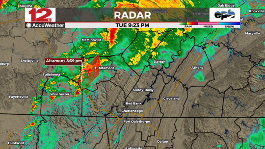
...A STRONG THUNDERSTORM WILL IMPACT CENTRAL SEQUATCHIE AND NORTHWESTERN MARION COUNTIES THROUGH 900 PM CDT...
At 819 PM CDT, Doppler radar was tracking a strong thunderstorm over Sewanee, or 9 miles east of Winchester, moving northeast at 50 mph.
HAZARD...Wind gusts up to 40 mph.
SOURCE...Radar indicated.
IMPACT...Gusty winds could knock down tree limbs and blow around unsecured objects.
Locations impacted include... Dunlap, Monteagle, Fiery Gizzard State Park, Griffith Creek, and Cagle.
#wdef.com/weather#tennessee river valley#chief meteorologist austen onek#chattanooga weather#[email protected]#wdef chattanooga#wdef-tv#wdef#wdef news 12#wdef.com#Sequatchie County TN#Marion County TN#Sewanee TN
0 notes
Text
First big blizzard in Wisconsin...and it is bad enough my area of state shut down almost everything by 3pm (including my work. AYYYYYY. first time we've ever closed for bad weather in the 4 years I've been there) hell even most the bars closed early so you know it's a doozy 😂
They pulled all the plows from the road and issued multi county wide tow bans.
Worst part is the wind, it's hitting 45 to 50 mph steady gusts. I live in an 100+ year old house and she be chillllllyyy. Heated blanket gonna be my bestie tonight.
Gotta get up at 530 to hopefully snowblow the drive and our neighbors, and then wait to see if my boss calls me to let me know we're opening late or not since I'm supposed to be in by 730am....which. was fine but now they're saying it's gonna snow into Saturday night instead of ending in the morning so I guess we'll see?
That's even if I can get out of my street. I'm on a side street that is a dead end in a valley area by the river....the one road in and out is near impossible to drive even in a truck if not plowed because the road goes up and down a couple small hills and the dip parts turn into ice rinks/snow traps 😬😬
Mother Nature really was like Yall Mad Because December Was Warm, Here Have 2 Snowstorms In 2 days But Make The Second one ~Spicy~
At least everything looks pretty. And once the wind dies down, it'll be enjoyable to get out in the wintery goodness
#personal#Blizzard Bennett be hitting hard loool#i took all the side roads home. took me almost an hour to drive the 10 miles home#the accidents were unreal#i think part of them pulling the plows also had to do with the fact multiple plows got hit by drivers whilr another couple got stuck#and a town over from me the cops had to go stop someone from attacking a plow driver#like what the actual fuck yall calm down and get in your houses#also the amount of customers who argued with us that we didn't need to close???#lile we had to eacort two out because they refused to leave after closing announcement#and another tried forcing their way in as we were leaving the building and locking up#like...nothing we have is that important. we a thrift store come on now
1 note
·
View note
Text

Youth services have been moved ONLINE tonight due to inclement weather!
Drop-In services for LGBTQIA+ youth ages 13 to 17 have moved online tonight. Please follow for updates regarding closures/online programming for other youth services this weekend such as elevate and ARC.
The National Weather Service has issued statements regarding the extended arctic cold snap coming to Southern Illinois this next week beginning tonight. There is a potential for negative wind chills, and Carbondale will see the single digits in addition to expected wind gusts tonight up to 50 mph.
To join online programming, visit www.rainbowcafe.org/discord and follow the included instructions on our website.
National Suicide and Crisis Lifeline: 988
LGBT National Helpline: 888-843-4564
The Trevor Project: 866-488-7386
Stay inside and stay safe this week! Remember that organizations like the Carbondale Warming Center and The Center for Empowerment and Justice will have their doors open for those needing a bit of warmth!
1 note
·
View note
Text
President Biden Amends Arkansas Disaster Declaration

Today, President Joseph R. Biden, Jr. made additional disaster assistance available to the State of Arkansas by authorizing an increase in the level of federal funding for emergency work undertaken in the State of Arkansas as a result of severe storms and tornadoes on March 31, 2023.
Under the President’s order today, Federal funds for debris removal and emergency protective measures, including direct federal assistance has been increased to 100 percent of the total eligible costs for a continuous 30-day period of the State’s choosing within the first 120 days of the incident period.
--- End of White House Statement. ---
What Happened in Arkansas?
On the afternoon of April 25th, people across Arkansas could feel that something terrible was about to happen. Temperatures had soared into the 70s and 80s by 1 PM CDT with a supercell showing signs of potentially becoming tornadic in northern Pike County which eventually spread southwest over Saline County.
Then at 2:03 pm, a Tornado Warning for Little Rock (Pulaski Co.) was issued....and it only got worse from there!
At 2:18 pm an incredibly destructive tornado abruptly spun up just five miles west/southwest of Interstates 430 & 630 prompting emergency dispatchers to declare an official 'Tornado Emergency.'
On March 28th, 2020 a powerful tornado struck Pulaski County and Lonoke counties in Arkansas. Rated EF3/165 mph on the Fujita scale at its peak intensity, it left an impressive 34-mile trail of destruction between Little Rock and Cabot.
In total there were 2,700 structures impacted with some particularly severe damage to the top floors of apartment buildings as well as leveled homes and churches around Napa Valley Drive near Interstate 430 and Jacksonville.
Sadly 1 person was killed whilst 50 people had to be admitted into hospital for their injuries caused by the catastrophic winds; power outages affected over 60,000 households across both regions too - a stark reminder of how quickly Mother Nature can change things if we are not prepared properly!
Most concerning however is that Burns Park alone lost 10 thousand trees due to this storm system's formidable gusts.
On the afternoon of April 11th, two separate supercells spawned tornadoes in Arkansas. The first tracked from Wynne to Turrell and across the Mississippi River into Tennessee. This tornado was at least an EF3 strength, with fatal consequences for several individuals as homes were obliterated and trees uprooted or snapped along its path.
Five miles southeast Hickory Plains a weaker storm caused destruction by tipping over a truck on Interstate 55 while between Alco & Fifty-Six (Stone County), an EF2 tornado lifted roofs off buildings and even shifted houses away from their foundations before it dissipated minutes later.
This event was devastating for many, featuring nearly a thousand reports of tornadoes, damaging wind, and large hail concentrated in the north/east region around Arkansas.
At least 120 tornadoes were reported with nearly a dozen being rated EF3 or higher - making them particularly destructive forces.
The most dangerous tornado (EF4) traveled 43 miles from Ottumwa to Iowa City while an equally hazardous EF3 covered 86 miles south of Hornsby to east Hohenwald resulting in 9 fatalities.
Additionally, on April 1st history was made when another rare EF3 tornado developed which tied as Delaware's strongest ever recorded!
Sources: THX News, The White House & The National Weather Service.
Read the full article
0 notes
Text
EAS #2
...A strong thunderstorm will impact portions of northwestern Greene and Clay Counties through 200 PM CST... At 124 PM CST, Doppler radar was tracking a strong thunderstorm over Maynard, or 10 miles northeast of Pocahontas, moving east at 55 mph. HAZARD...Wind gusts up to 50 mph. SOURCE...Radar indicated. IMPACT...Gusty winds could knock down tree limbs and blow around unsecured objects. Locations impacted include... Corning, Lafe, Reyno, Knobel, O'Kean, McDougal, Success, Peach Orchard, Delaplaine, Datto, Evening Star, Crockett, Heelstring, Stonewall, Tipperary, Hickoria, Case, Brookings, Knob and Twin Oaks. PRECAUTIONARY/PREPAREDNESS ACTIONS... If outdoors, consider seeking shelter inside a building.
#severeweather#weather#storm#thunderstorm#lightning#stormchaser#stormchasing#nature#clouds#rain#sky#tornado#stormclouds#ig#storms#weatherphotography#stormchasers#supercell#meteorology#extremeweather#thunder#thunderstorms
0 notes
Text
SAN FRAN FACES TERRIBLE STORM
The National Weather Service’s Bay Area office issued a frank and dire warning to citizens in a statement, saying the storm, which is currently forecast to begin peaking Tuesday night and Wednesday morning, could bring about flooding and the loss of life.
"To put it simply, this will likely be one of the most impactful systems on a widespread scale that this meteorologist has seen in a long while," the warning read. "The impacts will include widespread flooding, roads washing out, hillside collapsing, trees down (potentially full groves), widespread power outages, immediate disruption to commerce, and the worst of all, likely loss of human life. This is truly a brutal system that we are looking at and needs to be taken seriously."
A flood watch has been issued for the entire Bay Area from 4 a.m. Wednesday through 4 p.m. Thursday, with some areas expected to get up to 10 inches of rain. Wind gusts are expected to hit 50 mph, equivalent to a moderate tropical storm. Those are expected to peak between Wednesday afternoon and midnight.
0 notes
Text
Nicole intensifies to a Cat. 1 hurricane – Action News Jax
New Post has been published on https://petnews2day.com/pet-news/cat-news/nicole-intensifies-to-a-cat-1-hurricane-action-news-jax/
Nicole intensifies to a Cat. 1 hurricane – Action News Jax
Jacksonville, Fl. — The “Buresh Bottom Line”: Always be prepared!…..First Alert Hurricane Survival Guide… City of Jacksonville Preparedness Guide… Georgia Hurricane Guide.
STAY INFORMED: Get the * FREE * First Alert Weather app
FREE NEWS UPDATES, ALERTS: Action News Jax app for Apple | For Android
WATCH “Preparing for the Storm”
WATCH “The Ins & Outs of Hurricane Season”
READ the First Alert Hurricane Center “Survival Guide”
LISTEN & WATCH “Surviving the Storm” – WOKV Radio & Action News Jax
***** ALWAYS CHECK & RE-CHECK THE LATEST FORECAST & UPDATES! *****
REMEMBER WHEN A TROPICAL STORM OR HURRICANE IS APPROACHING: Taping windows is *NOT* helpful & will not keep glass from breaking.
Realize the forecast cone (”cone of uncertainty”) is the average forecast error over a given time – out to 5 days – & *does not* indicate the width of the storm &/or damage that might occur.
*** Impacts from Nicole including very high rip current risk at NE Fl./SE Ga. area beaches through Fri… folks living in or traveling to the Bahamas, Florida & east coast of the U.S. should stay up to date on the latest forecasts *** ….
The most anomalous (unusual/rare) part of this storm will be the potential for a relatively strong tropical system at a rather far north latitude for this late in the season in addition to a prolonged period – ~5 days of beach/coastal impacts…
For Jacksonville/NE Fl./SE Ga. specifically (given *current* forecast of ‘Nicole’ with improving conditions from west to east & south to north from Fri. afternoon through the weekend):
* Strong onshore flow will continue & become even stronger through Thu. with life threatening rip currents & dangerous overall marine conditions.
* Surf & breakers reaching double digits including 12-15+ feet Thu., only slowly subsiding Fri. Seas will be 20+ feet & extremely rough just offshore. All marine craft should remain in port & secure vessels & equipment.
* Storm Surge (water above typically dry ground at high tide) will average 3-5 feet along the coast & the St. Johns River through much of d’town Jacksonville to near the Buckman Bridge… 2-4 feet south of the Buckman through St. Johns/Clay/Putnam Co. If your property experienced flooding during Ian 6 weeks ago or Irma (2017), then flooding is probably going to occur in your area from Nicole. There may be a few spots where storm surge reaches 6-7 feet over especially Southern St. Johns & Flagler Co. where beaches & dunes have been heavily compromised by Ian. Surge values may be locally higher due to wave action, heavy rainfall &/or geographical/topograhical nuances.
* St. Johns River – Potentially significant dock & shoreline damage through Fri. Strong winds from the south by late Thu./Thu. night into Fri. morning will help push water northward up the St. Johns River into parts of downtown Jacksonville at times.
* Beach erosion will become heavy to severe – a critical facet of the storm considering the recent damage from Ian
* Winds – BEACHES/INTRACOASTAL/ST. JOHNS RIVER – Tonight: increasing to 20-35 mph with 40+ mph gusts… Thu.: peak at 40-50 mph with 60+ mph gusts becoming out of the south by late afternoon into the night… Fri.: shifting to offshore – out of the west at 20-30 mph with higher gusts… much lighter winds by Fri. night/Sat.
INLAND (NEAR/WEST OF I-95) – Tonight: 15-25 mph with 30+ mph gusts… Thu.: peak at 30-40 mph with a few 50+ mph gusts… Fri.: shifting to out of the west then northwest through the day at 20-30 mph, higher gusts in the morning, gradually diminishing through the afternoon/evening.
* Rainfall will average 2-3″(+) along the coast… 1-2″+ inland (near/west of I-95)
* Flooding will be a daily threat at the beaches, especially at high tide – becoming more significant with each day through this week. There will also be an astronomical boost due to the full moon phase (each phase of the moon is ~2 1/2 days in duration) which began Tue. Ponding & – eventually flooding – will also occur along the St. Johns River & its tributaries.
* As Nicole moves south then west of Jacksonville while turning northward, there will be a tornado & waterspout threat later Wed. night through Thu. across NE Fl. & SE Ga.
* Primary inland impacts are likely to be realized Wed. night through Thursday in the form of wind, rain, flooding & tornadoes BUT WILL BE DEPENDENT ON EXACT TRACK & STRENGTH OF THE STORM.
Low pressure – ‘98-L’ started to develop over the SW Atlantic north of Puerto Rico & was upgraded to subtropical storm “Nicole” early Mon., the 14th named storm of the Atlantic season which is right on avg. & close to the Nov. 19 avg. of the occurrence of the 14th named storm. Nicole transitioned to a tropical storm (purely warm core) by midday Tue. & then reached hurricane (Cat. 1) strength a bit before 6pm Wed., the 7th hurricane of the Atlantic season which happens to be right at the seasonal average which – on avg. – occurs on Nov. 15th. Given the very warm water from Fl. to the Bahamas in addition to an upper ridge building near & north of the storm while – at the same time – an upper level trough that helped spawn Nicole weakens & moves away, Nicole should manage to reach hurricane strength before the Fl. landfall. Nicole has turned more west & southwest & will veer more west then northwest & as the ridge to the north briefly becomes stronger. At the same time, another upper trough moves into the U.S. Lower 48 helping to create the alleyway from Fl. up the eastern seaboard as the brief ridge shifts east over the Atlantic. This interplay helps to dictate the longer range movement – acceleration to the north/northeast – as well as aiding some in the strength of Nicole by helping to create strong upper level outflow + enhancing the low level “baroclinicity” – the interaction of cold, dry, polar air vs. tropical warmth & humidity. In other words, the transition back to a post-tropical low could mean a slower decrease in Nicole’s intensity even though Nicole will be losing tropical characteristics & will no longer be over the warm ocean. Nicole should dissipate or become absorbed by another midlatitude nontropical low over the weekend.
In general, conditions are at least somewhat favorable for additional strengthening before the Florida landfall. There will still be some shear + only moderate mid & upper level moisture but sea surface temps. are warm including pretty significant deep oceanic heat content (warm water to a deep depth) not to mention Nicole will traverse the very warm Gulf Stream Wed. I’ve noticed multiple times over the last 20+ years that southwest moving/digging tropical cyclones often intensify.
Global forecast models continue to be in rather remarkable agreement (for a storm in its infancy & not yet well organized) with the low moving west/southwest… hitting Southeast Florida… then as far west as the far Eastern/NE Gulf or Fl. west coast to near the Eastern Panhandle… before feeling the effects of the strong upper level trough that will then finally pick up the storm & steer it north & northeast while accelerating. The GFS remains the farthest west with Nicole. The European & UKMET models are similar in strength & take Nicole a little farther east before a turn north/NE. All 3 models are similar on timing. As I previously mentioned, the approaching upper level trough late in the week should help to “ventilate” the mid & upper levels of the atmosphere over Nicole which should at least maintain the storm for a longer time than might otherwise be the case. In addition, increasing southwesterly shear will be in tandem with Nicole’s movement lessening the effect of the increasing shear of the front right quadrant of the jet stream. As Nicole gets “captured” by the trough & hooks up with a cold front, there will be a transition back to post (non) – tropical that will then accelerate the storm to the northeast moving up the U.S. east coast by the weekend. Dry air will quickly spread eastward “under” – to the south – of Nicole’s center bringing a quick end to rainfall with diminishing winds & clearing skies for NE Fl./SE Ga. by late Fri./Fri. night/Sat. In fact, the heaviest, most persistent rain for NE Fl. & SE Ga. should diminish by at leastThu. night followed by scattered showers & a few t’storms Friday ahead of an eastward moving cool front extending south from Nicole.
The forecast is for Nicole to hurricane strength between the Bahamas & Fl. should hit SE Fl./the east central coast as a Cat. 1 hurricane. Impacts are expected for all of Fl. – except for the Western Panhandle & the Mid & Lower Keys -… in addition to the Bahamas + parts of the Carolina’s to perhaps as far north as Chesapeake Bay & New England in the longer term. Heavy rain will cause potential flooding inland across Georgia, the Carolina’s, Tennessee, Virginia & Maryland & possibly parts of the Northeast though the fast movement will keep rainfall totals on the lower side.
REMEMBER: A skinny forecast cone only means higher forecasts confidence in the track NOT where the greatest impacts will occur. The wind field is wide. In fact, tropical-storm-force winds extend outward up to 460 miles (740 km) especially to the north of Nicole’s center.
NHC interactive potential storm surge flooding map (inundation) * here *.
N.W.S. Jacksonville:
Melbourne N.W.S.:
N.W.S., Miami:
Tampa N.W.S.:
Radar imagery courtesy S. Florida Water Management District (purple line is the forecast track for “Nicole”):
Spaghetti plots for Nicole – includes ensemble models (NOAA: address underlying uncertainties in the input data such limited coverage, instruments or observing systems biases, and the limitations of the model itself. GEFS quantifies these uncertainties by generating multiple forecasts, which in turn produce a range of potential outcomes based on differences or perturbations applied to the data after it has been incorporated into the model. Each forecast compensates for a different set of uncertainties):
Let’s do some “examinin’”:
Shear is currently strong across most of the SW Atlantic with speeds of 30+ mph. However, the upper level atmosphere is undergoing some significant changes that will include somewhat less shear & a building upper level ridge to the north of the low. At the same time, a strong upper level trough will be digging into the Central U.S. & eventually into the Eastern U.S. This strong trough will be critical to the eventual movement – including curvature to the north/northeast – & intensity of the storm. The added upper level ventilation from the trough may aid in intensifying the storm some… or at least maintaining the storm as it eventually accelerates to the northeast. Following this trough, there will be a serious invasion of cold air across the Lower 48 as the tropical system seems to be a catalyst for a pattern flip reminiscent of “Wilma” in 2005 which hit Fl. Oct. 24th & was followed/guided by a deep trough moving across the Lower 48.
Deep oceanic heat content (OHC) is pretty impressive over the SW Atlantic though Nicole will generally stay north of the real warm deep water (with the exception of the Gulf Stream):
The upper level forecast for Wed. & Fri. respectively showing the developing alleyway from Florida N/NE up the east coast:
Water vapor loop shows pockets of dry air (dark blue) across portions of the Atlantic Basin along with a lot of “swirls” (low pressure) along with “bands” of higher moisture near & ahead of fronts – common as we get deeper into autumn. ‘Nicole’ will be surrounded by a good deal of dry air this week.
November tropical cyclone origins:
Averages below based on climatology for the Atlantic Basin through November:
Wind shear:
Saharan dust spreads west each year from Africa by the prevailing winds (from east to west over the Atlantic). Dry air – yellow/orange/red/pink. Widespread dust is indicative of dry air that can impede the development of tropical cyclones. However, sometimes “wanna’ be” waves will just wait until they get to the other side of – or away from – the plume then try to develop if other conditions are favorable. In my personal opinion, way too much is made about the presence of Saharan dust & how it relates to tropical cyclones. In any case, we’ve had several large dust plumes spread west to the Caribbean & Gulf with the peak of Saharan dust typically in June & July.
2022 names….. “Owen” is the next name on the Atlantic list (names are picked at random by the World Meteorological Organization… repeat every 6 years). Historic storms are retired [Florence & Michael in ’18… Dorian in ’19 & Laura, Eta & Iota in ‘20 & Ida in ‘21]). In fact, this year’s list of names is rather infamous with “Charley”, “Frances”, “Jeanne” & “Ivan” retired from the ‘04 list (all hit Fl.) & “Matthew” was retired in 2016. The WMO decided – beginning last year – that the Greek alphabet will be no longer used & instead there will be a supplemental list of names if the first list is exhausted (has only happened three times – 2005, 2020 & 2021). The naming of tropical cyclones began on a consistent basis in 1953. More on the history of naming tropical cyclones * here *.
East Atlantic:
Mid & upper level wind shear (enemy of tropical cyclones) analysis (CIMMS). The red lines indicate strong shear:
Water vapor imagery (dark blue indicates dry air):
Deep oceanic heat content over the Gulf, Caribbean & deep tropical Atlantic:
Sea surface temp. anomalies:
SE U.S. surface map:
Surface analysis centered on the tropical Atlantic:
Surface analysis of the Gulf:
Caribbean:
GFS wave forecast at 48 & 72 hours (2 & 3 days):
Atlantic Basin wave period forecast for 24, 48 & 72 hours respectively:
The East Pacific:
West Pacific:
Global tropical activity:
Cox Media Group
0 notes
Text
Wichita falls precipitation totals

WICHITA FALLS PRECIPITATION TOTALS ARCHIVE
WICHITA FALLS PRECIPITATION TOTALS PLUS
Those increasing bursts of extreme precipitation carry profound economic and human health risks, the likes of which have been on display most recently in eastern Kentucky. The numbers show that 2021 was a record-setting year for extreme rainfall events, with dozens of places logging their wettest day in generations.Ī separate Climate Central report this spring found that of 150 locations the group analyzed, 90 percent now experience more average rainfall per hour, compared with 1970. “It was just too much water,” Hadley said.Īn analysis of weather data by the nonprofit group Climate Central found that nearly three-quarters of locations the group examined around the country have experienced an increase in the amount of rain falling on their annual wettest day since 1950 - particularly along the Gulf Coast and Mid-Atlantic. The area’s sprawling drainage systems, parts of which date to the 19th century, were quickly overwhelmed. The River des Peres swelled beyond its banks. Louis Sewer District, said of the recent storms that dumped more than 9 inches of rain there in a matter of hours, shattering the previous daily record from 1915. “What happened was way more than the system - any system - can handle,” Sean Hadley, spokesman for the Metropolitan St. But as more water falls from the sky more quickly in many places, those challenges have become only more urgent. in two daysįrom populated cities to rural outposts, the United States has long struggled with antiquated sewage and wastewater networks, outdated bridges and crumbling roads and culverts. How two 1-in-1,000 year rain events hit the U.S. “The infrastructure we have is really built for a climate we are not living in anymore,” said Andreas Prein, a scientist at the National Center for Atmospheric Research (NCAR) who studies extreme precipitation. But as it also fuels once-unthinkable amounts of rain in single bursts, the problem of so much water arriving so quickly is posing serious challenges in a nation where the built environment is not only outdated but increasingly outmatched. The warming atmosphere is supercharging any number of weather-related disasters - wildfires, hurricanes, crippling heat waves. Places around the nation are facing more frequent, more extreme precipitation over time - a reality laid bare once again by the record-shattering rains and catastrophic flooding in eastern Kentucky and St. Huntington, W.Va., and Sioux City, Iowa, are seeing deluges roughly 30 percent more extreme than in 1970. The Wichita area is experiencing rains about 40 percent more fierce these days. Note that this is just one model so while it may be very accurate for days 1-3, take it with a grain of salt towards day 5.At one weather station in Fairbanks, Alaska, each hour of rainfall is about 50 percent more intense, on average, than it was a half-century ago. Other parameters available for your viewing interest include relative humidity, cloud cover, intensity of sunlight (dependant on both cloud cover and season), and precipitation.
WICHITA FALLS PRECIPITATION TOTALS PLUS
Add up each symbol to get the total wind (two large dashes plus one small dash would mean 25 mph winds for example). Each triangular flag represents 50 mph worth of wind. Each small dash represents 5 mph while each large dash represents 10 mph. Note that the wind blows from the side of the barbs containing the little dashes so if the dash is to the NE of the dot, you’re looking at a NE wind. The second panel shows winds and wind gusts. The first panel shows temperatures and overall weather conditions (sunny, cloudy, rainy, etc.). This product is designed to give you a quick look at everything you need to know for the next 3-5 days of weather. Adfree Plus (with extra features) Extra.Lake Murray, Ardmore OK (WeatherOK, USA).
WICHITA FALLS PRECIPITATION TOTALS ARCHIVE
Base reflectivity (with archive since 1991).Radar & Lightning Radar & Lightning Radar.Forecast Ensemble Heatmaps (Up to 5 models, multiple runs, graph up to 16 days) EXTRA.Forecast Ensemble (Up to 5 models, multiple runs, graph up to 16 days).Forecast XL (Graph and table up to 10 days - choose your model).14 day forecast (ECMWF-IFS/EPS, graphs with ranges).Meteograms (Graph 3-5 days - choose your model).Weather overview (Next hours and days, 14 day forecast).Central Europe Multi Model HD (3 days) new.Tropical cyclone tracks (ECMWF/Ensemble).
0 notes
Text
What to Know About Hurricane Ian Before, During, and After the Storm
Hernando, Citrus and Pasco County Government Offices of Emergency Management continues to monitor and inform our community about Hurricane Ian. We will continue to keep you updated before, during and after the storm.
- Mandatory Evacuations have been issued for all areas west of US 19, which includes evacuation zones A, B, and C. All residents living in coastal and low-lying areas, as well as manufactured homes county wide, are included
- Report damages to the Emergency Operations Center Hernando (352) 754-4083, Citrus (352) 249-2775, Pasco (727) 847-2411
- Potential 39 mph or greater max winds, gusts up to 50-60 mph on Wednesday and will increase on Thursday and Friday
- Flash flood risk is moderate 75%
- 4 ft – 6 ft storm surge above normal high tide is expected along the coast
- Citrus, Hernando, and Pasco Counties are expected to receive 5 to as much as 10 inches of rain
- Power outages are possible. All residents should remain indoors.
- First responders will NOT be responding to emergencies during winds that exceed 40-45 MPH, or conditions deemed dangerous. Once the winds subside, personnel will be out as soon as possible to assist
- Use the telephone to communicate emergency information unless telephone services are unavailable. Call and/or text 9-1-1
- Residents in non-evacuation zones should make final preparations now to stay safe through tropical storm or hurricane force winds. Anyone who does not feel safe in their home is advised to consider staying with a friend or family member in a non-evacuation zone or at a public shelter
- All County Offices will reopen Monday, October 3, 2022
Before the storm
- Charge your phone; remember, texts work when cell service doesn’t
- Decide on one point of contact (out of town preferably) to communicate with to save on power; tell people to get updates from that person. Make sure your friends and family understand you will likely lose connection
- Fill your bathtub and empty containers with water
- Stay calm – keep kids and pets calm; talk to your children about what will happen – be clear and honest, but not scary – warn them that electronics may not work
- Take a look around your neighborhood. Consider inviting those who are alone and who are elderly into your home to decrease the anxiety
During the storm
- Close interior doors. Secure and brace external doors
- If power goes out, use a weather radio for alerts. For light, use flashlights, battery-operated lanterns, or chemical light sticks
- Stay indoors and stay calm. Do not be fooled if there is a lull; it could be the eye of the storm and winds may pick up again
- Make sure to have extra batteries for weather radios and keep devices charged
- Hurricane Ian is expected to cause substantial storm surge as the storm moves to the north, which may occur after the hurricane force winds have subsided. Do not assume that the danger has passed
- Stay in your home until officials say that it is safe to go out
If your home is breached in a Hurricane
- Take refuge in your safe room, an interior room, closet, or hallway on the lowest level of your home. Remember, the center of your house is the safest.
- Lie on the floor under a table or other sturdy object if you cannot make it to a safe room.
- Consider leaving your home only if remaining there poses an imminent threat to your life.
- Wait until the storm has passed to tend to any damage
After the storm
- It could take days for all of the roads in Hernando County to be cleared. During this time, stay in your home. Wait for updates from officials
- If you must be on the road, do not drive through standing water
- The conditions that you faced during the storm will likely continue while crews work to restore power, water and sewer service. Continue to use safety measures, such as boiling water, until officials announce that it is safe. Make use of your hurricane survival kit to meet your everyday needs
- Do not drive or walk near downed powerlines
- If emergency water and supplies are needed, announcement will be made as information becomes available
Stay tuned for weather updates through weather alert radios, local media outlets, and each county's website Citrus, Hernando, or Pasco, and social media accounts.
Read the full article
0 notes
Text
Siding services - Engineered wood - Roofing gurus
The life of a house can be tough, and so can the elements it faces. That’s why we install LP Smart Side – engineered wood from the ground up to be the most durable siding on the market. Combining the aesthetics of real wood with engineered wood strand technology, LP Smart Side provides superior durability, allowing your home to stand up to all sorts of challenges, including not being eaten by termites or cicadas or whatever else is out there terrorizing homes. And whether you’re looking for a replacement for your current siding or new siding for a new home, we have a beautiful selection of colors and textures that are bound to match your personal style!
Composition :
While traditional wood is sourced from trees such as cedar and redwood, engineered wood uses treated wood strands combined with wax and resin binders for strength. This allows engineered wood to be designed to any shape or size and manufactured using techniques that would not work with natural woods.
Efficiency :
LP SmartSide engineered wood siding is a flexible, solid-wood product that allows for a variety of installation styles. It may be installed horizontally, vertically, or on an incline. Its flexibility makes it easier to work with than other options, and it is quick to install.
Durability :
LP SmartSide treated engineered wood trim & siding is stronger than traditional wood and can withstand wind gusts up to 200 mph. Plus, it comes with a 50-year limited warranty, so you know you’re getting the best product for your home!
Protection :
LP SmartSide offers superior protection against hail, wind, moisture, fungal decay and termites. Composite wood siding is mixed with different fibers and strands of various woods
Engineered wood siding is a great alternative to traditional wood siding. Its engineered construction and synthetic backing make it perfect for lightweight, energy-efficient construction. With so many colors and textures to choose from, you can get the look of real wood without the upkeep.
Call us today to schedule your free no-obligation estimate.

#Best roofing installation#Commercial Roofing Installation Contractor in roselle#Home Siding Contractors in Roselle#Siding contractors#Insulated vinyl siding#Vinyl siding installation company#Siding companies near me#Gutter contractors in Roselle#Gutter installation services#Gutter repalcement services#Rain gutter experts in Roselle#vinyl gutter installation near me#Best roofing companies in Roselle#Top roofing contractors in USA#Residential roofing companies chicago#Gutter repair services#Best roofing and building services#Roselle Professional roofing company#Best roofing services Roselle#residential and commercial roofing services
0 notes
Text
Strong winds in Southern California will meet with sizzling, dry circumstances that would spell the potential for wildfire by way of week’s finish, forecasters stated. The National Weather Service has issued a wind advisory by way of 8 p.m. Tuesday in parts of Los Angeles and Ventura counties, together with gusts of as much as 50 mph in Lockwood Valley, Mt. Pinos, Acton, Mt. Wilson and alongside the I-5 hall. Late afternoon and night winds often called sundowners are additionally on faucet close to the Santa Ynez Mountains in Santa Barbara County over the subsequent a number of days, in line with David Sweet, a meteorologist with the climate service in Oxnard. “It’ll be pretty darn windy in Santa Barbara County,” Sweet stated, including that the gusts will “probably be a week-long affair.” Last yr, sundowners helped gas the 17,000-acre Alisal fireplace close to Goleta as they raced down the slopes of the mountains towards the ocean. On Sunday night, sundowners once more powered a small blaze close to Cathedral Oaks and Highway 154. Crews have been in a position to cease progress on that fireplace, dubbed the Bridge fireplace, at about 10 acres round 8 p.m., in line with the Santa Barbara County Fire Department. But officers stated it could possibly be a preview of what’s to return because the week’s winds meet with rising temperatures and low humidity ranges, elevating the danger of fireplace climate throughout the area. “Any fire start will likely grow rapidly!,” the climate service stated on Twitter. “Use caution and be fire safe!” The San Gabriel and San Fernando valleys can be among the many warmest areas in L.A. County, in line with Sweet, with temperatures in some areas “anywhere from 10 to 15 degrees above normal” for the time of yr. Burbank is anticipated to achieve 92 levels on Wednesday and 95 by Friday, whereas downtown Los Angeles will simmer within the mid-to-high 80s, Sweet stated. Humidity ranges are anticipated to drop to the only digits or teenagers.“Away from the coast, it’ll be toasty,” Sweet stated. Temperatures can be even hotter within the Inland Empire and decrease and excessive deserts, with San Bernardino and Victorville anticipated to close 100 levels Friday and Saturday, whereas Palm Springs may skyrocket to 113. The circumstances have already spelled hassle close to Thermal, the place a blaze often called the 62 fireplace chewed by way of heavy dried vegetation on Sunday, in line with the Cal Fire-Riverside County Fire Department. By Monday morning, the fireplace was about 25% contained at 84 acres. It is certainly one of a whole bunch of blazes which have burned 1000's of acres throughout the state up to now this yr, in line with the California Department of Forestry and Fire Protection, which has warned that fireplace season is increasing within the state.In May, the devastating Coastal fireplace in Orange County burned 20 properties and broken practically a dozen others, whipped by winds and fueled by drought-dried vegetation. Sweet stated the warmth ought to begin to break by the top of the weekend, when low clouds and fog will return to the L.A. space. The San Gabriel Valley will see highs within the decrease to mid-80s by Sunday, he stated. window.fbAsyncInit = function()
FB.init( appId: '134435029966155', xfbml: true,
version: 'v12.0'
);
;
if (document.getElementById('facebook-jssdk') === null)
const js = document.createElement('script');
js.id = 'facebook-jssdk';
js.src="
js.async = true;
js.setAttribute('crossorigin', 'anonymous')
window.setTimeout(function ()
document.head.appendChild(js);
, 1500);
0 notes
Text
I’ve got to get some stuff off my chest and this seemed like the place to do it. I’m mostly just screaming into the void, and there’s going to be some heavy topics so skip ahead if you want.
Content warnings for gun violence, climate change, and wildfires.
My home region has had an absolutely horrible week. Monday, a gunman carried out a horrific spree of premeditated murders, killing five and wounding more. The victims were previous coworkers at a tattoo collective and a hotel clerk that he did not know. He wounded a policewoman who returned fire and killed him. His victims also included a latina tattoo artist and muralist, an indigenous latina activist and spiritualist, and he attempted to kill an entire family who run a tattoo parlor now out of their home.
How this man had access to guns is beyond me (I mean, it’s the USA so yeah, he had access, but it’s so fucking broken). He had been ‘investigated’ by the Denver Police in 2020 and 2021, possibly for the novels he self-published under a pseudonym in which a protagonist with his legal name hunted down and killed people with the SAME NAME as his victims in their homes. He wrote novels about him doing exactly what he wanted to do, and then did those things. Again, he should not have had access to guns after that. There should be laws that would allow actions like that to empower law enforcement to confiscate weapons and make sure he could not buy more.
And then, yesterday. December 30, high winds came through preceding a storm system that would deliver only the second snowstorm of the season to Colorado’s Front Range (the area east of the Rocky Mountains, typically describing the area from Pueblo to Fort Collins, CO). For context, this is incredibly not-normal. We have had an abnormally warm and dry fall and winter so far. Growing up, it was normal to have first snowfall of the year in September or October, and I have known many halloween nights with fresh snow on the ground. This year, the first snow of the year for the front range did not come until mid-December and only left a light dusting of snow.
This new storm is still incoming and is supposed to deliver several inches, but yesterday December 30, what is likely downed power lines sparked several grass fires near the towns of Superior and Louisville, CO. High winds, sustained speeds near 50 mph and gusts up to 110 mph spread the fire incredibly quickly. Within hours, the towns were evacuated and structures were catching fire. Firefighters couldn’t do anything but evacuate people because the winds were too strong and unpredictable. Air support for the fire was also impossible with the winds.
In less than six hours the fire became the most destructive fire to humans in Colorado history. Literally hundreds of homes and businesses have burned to the ground. My parents evacuated to my house, and then the pre-evacuation zones got too close for comfort to our house, so we packed up impossible and difficult to replace things and we all drove up to another friend’s house further from the fire. My home is fine, I’m writing from there, and while we don’t know for sure, my parent’s home is probably fine, but I and my family spent hours yesterday thinking that the home I grew up in was going to go down in flames. However, there are already people we know who we also know for sure their homes are completely gone. The homes in Superior, Louisville, and Marshall that remain have no heat, and a boil-water order for the near future. Thousands of people who woke up yesterday morning planning their New Years Eve and thinking about the impending snowstorm are now homeless, with everything they own turned to ashes. Many people were at work, or on vacation, and had zero chance to make it to their home to rescue what they had. It has been absolutely heartbreaking looking at the aftermath. The fires are contained and will likely be extinguished soon, but entire neighborhoods have been razed. This is the direct result of climate change
The single bright spot is that there has only been one hospitalization so far, a police officer who was struck by debris from the winds, and no recorded fatalities. There was only one missing person report so far, and that person has been located. It’s amazing that there has not been more loss of life.
If you’ve read this far, you’re amazing. Please be gentle to each other. If you want to and are able to help, you can donate to:
Boulder County Wildfire Fund
American Red Cross, Colorado Region Chapters
Boulder County Office of Emergency Management
#Colorado#climate change#wildfires#long post#gun violence#Marshall Fire#Denver shooting#it's been a rough week
11 notes
·
View notes
Text
I'm not sure if that's a good thing
“Well you’re definitely the first.”
This past week, we screened-in the eastern facing porch on the side of the cabin. The porch slopes to the South, with the brick-on-dirt floor crumbling in that direction as well until it reaches uneven slabs of stone acting as steps down to the “yard” below. A mixed material retaining wall wraps beneath the steps to the south facing garage, holding up one corner of the narrow deck on the front of the house. The deck, in the heat of a high altitude summer, droops off the house like it’s daydreaming about the winter snow’s embrace. It’s safe to sit on, though I would not recommend leaning on the railing.
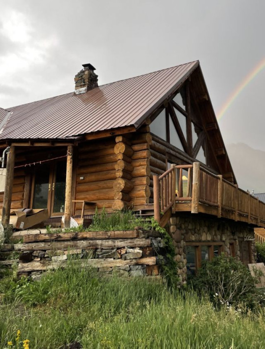
The side porch takes the brunt of the wind. Our wooden rocking chairs have been rocked some 20 feet into the yard more than once in the two months we lived here. In the myriad of threats we heard about the weather, most people included the wind. We all know how I feel about this ongoing weather intimidation tactic. I asked, “what speed are the gusts?”
“Oh, they get up to 70 miles per hour on some days.”
This was the first quantifiable piece of weather information someone had offered — an actual number we could react to with data and our historical personal experiences of various weather events. And our reaction was: uhhhh…. OK????
Look, I get it. No one’s preaching the skin benefits of -20 degree wind gusts at 70 mph, building snow drifts against your house in the span of minutes that Cooper could die in. I am not going to pretend that’s pleasant. But 70 mph? Any wind I’ve driven faster than does not intimidate me. I used to rally the horses at 12 years old in winds over 70mph to get them in the barn before the latest tornado whipped through. I helped shutter the resort in the BVI as the Category 5 hurricane rolled in. Even in Topanga, 70 mile per hour gusts were not uncommon in Santa Ana events. We had our single pane windows shatter more than once from debris in the wind. We taped cardboard up and went to sleep.
That “70 mph” was all I needed to hear to confirm our next project: we were going to build a catio for these cats, and we were going to do it on the pre-existing porch structure to save time and money.
We spent a week framing out the structure. We had to carve into the logs of the house to embed the wood supports for the framing.

And from there, every piece of wood was custom carved and cut to fit around the existing timber supports. The existing porch was so wildly uneven that there are gaps between each piece of old wood and the new framing. Our plan is to mix all the wood chips from the project with mortar/chinking and stuff the gaps — a good solution for the log cabin look. We built a plywood pony wall up to 28 inches from the interior of the porch, which gives a height of ~4-5ft from the exterior ground below. It’s capped with a 2x6” railing for even the fluffiest of cats to find a perch. The exterior will be wrapped with corrugated metal that we’ll quick-age to match the metal that wraps the bottom of the cabin. On the interior of the porch, we’ll use shiplap to hide the framing.
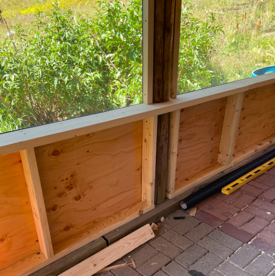
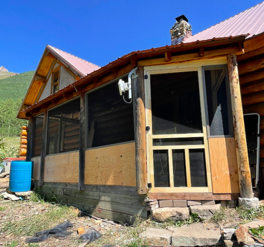
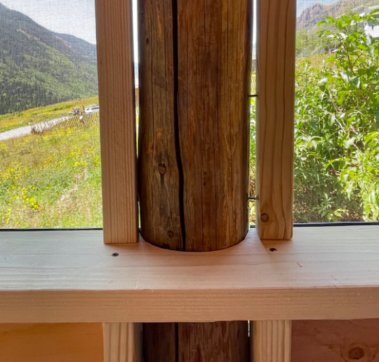
The screens themselves can withstand winds up to 120 mph, but to-be-determined if they can hold the weight of a growing maniac cat who has already tried to climb them. In the event the screens succumb to cat (or wind or snow or neighbor judgment) we’ll reinforce with metal mesh. We’re going to maintain this screen porch regardless of what the screen is.
We had the pleasure of running into one of our more industrious neighbors the other day, and Ben asked him, “hey we’re building a screen porch. Is this a terrible idea?”
He laughed. “Well you’re definitely the first.” But he liked it. Great way to diminish wind into the house. Simple way to regulate the temperature with massive south-facing windows. And indeed a practical outdoor safe haven for cats in predator territory. Just because you’re the first doesn’t mean you’re foolish — just foolhardy. There’s plenty of that here.
This town has the typical mountain town’s truncated version of a colonizers’ history: “established 1881.” But it was plenty established prior to that by the Uncompahgre Band of the Ute Nation, removed by the U.S. Army on September 7, 1881, nearly 140 years ago. The government relocated the Uncompahgre Ute People to Utah, and one year after the Ute were forcibly removed from their ancestral land, San Miguel County split off from Ouray County and was made its own political subdivision in the newly-formed State of Colorado.
In 1879, the ore-laden valley already had 50 people living in it, with a new narrow gauge railway only 2 miles away. By 1885, it was a town of 200 people. There was a hotel, a couple saloons, a pool hall. Winters were treacherous; the valley was and is prone to avalanches. But where there’s gold, there’s gumption. The power needed to run the stamp mill to process ore drove innovation. Timber was scarce at such high elevations, so a wood powered steam mill wouldn’t cut it. But the San Miguel River just a few miles down from the mine looked promising. Thus began the development and construction of the Ames Hydroelectric Generating Plant. It was a hit. In fact, it was so successful that the Ames Plant led to the adoption of alternating currents at Niagara Falls and eventually to being adopted worldwide as a viable power solution.
The plant remains, but the gold rush obviously didn’t. By 1940, the U.S. Census declared this little town I call home as tied for the lowest population in the country: 2 people. By 1960, it was one of four incorporated towns in the U.S. with no residents. But the joke was on the Census — the town’s single resident was just out of town the day the census came through. 1960 population: 1.
By 1980 the population grew to 38, 69 in 1990, and about 180 now. (Plus 51 dogs according to the town’s website.) With modern amenities, it’s easier to be here. Studded snow tires, satellite internet, solar panels, instant coffee. No matter the hardships, there’s the reality of the present. In the 1880s, as the town boomed, the Ouray Times declared, “it will be at no distant day a far more pretentious town than it is now.” That day hasn’t exactly arrived, but I guess it depends on what you consider pretentious. I don’t think the town claims any airs of excellence beyond what’s true. In fact, the town hardly claims anything at all. There’s no sign indicating it’s even here. There’s just the old side and the new side.
The new side, the Eastern half, was drawn out in the early 1990s, some 100 years later, and is separated from the Old Town by an avalanche zone—preserved open space for hiking in the summer, preserved open space for surviving in the winter. The town forbids short-term rentals, no one has a fence, dogs roam free, and all the houses have that cabin look to them. A boulder nests in a grove near a trailhead in the center of town with a plaque paying respect to the Utes who called this valley home. There’s no industry here. No businesses allowed. If you want a $7 latte, you can drive the 14 miles required to get it, assuming there’s not an avalanche blocking your path. You can, however, buy a pink lemonade in a
solo cup at the permanent lemonade stand run by the local feral child mafia. Crystals (rocks) can be purchased for an additional cost. We bought one, hoping to buy favor at the same time.
The town plan has a few guiding principles, and it’s all in the name of preservation. We must preserve:
1 - the quiet atmosphere
2 - the rustic character
3 - the natural setting
And finally:
4 - protect the health and wellbeing of the people here
No snowmobiles, no ATVs, no drones. In fact, the only sign of the outside world here are the passers-through. When you take the dirt road through town to the end, you enter National Forest, and you can hike over the pass saddle at nearly 12,000 feet before descending down the other side into Silverton. The pass road climbs rutted through an aspen forest before scaling across a scree field and then lurching over to the other side. Every day, it seems like 30 or so Texans and Arizonans in lifted and loud Jeeps with unused mods climb over this mountain in the comfort of their air conditioning, simply to drive down the other side. You could hike it, ride it, run it, and ski it, but they don’t. They rev their engines, kicking up dust in a town of feral children and roaming dogs, staring at us instead of waving.
I’ve lived here for two months and look how salty I am. I’ll fit in yet.
But today, there is a temperature that whispers of perfect trails and the dwindling of ogglers driving 35 in a 15. It’s already snowed in the mountains we see from our kitchen. Today, like a dedication to the Septembers of our youth, you can feel a chill in the air. A temperature akin to pencils and sweaters and reinventing yourself. A temperature that doesn’t exactly sing “screen porch” but could if you had the right slippers on. That’s what I did this morning: put my slippers on and sat there in the cool mountain morning air, thinking about the cemetery behind our house, about the Ute tribe, about the miners, about the mailman who died on Christmas in 1875 on the pass, about the 5 people who died in avalanches here just last year, about the people in their cars on their phones driving through, and all the people who’s very first question to us was, “so are you gonna live here part-time or full-time?”
Maybe it will be a hard place to live. But at least we’ll have a screen porch.
Every week I'm writing about moving to log cabin in a small town at 10,000 feet. Subscribe here for free: tinyletter.com/keltonwrites
11 notes
·
View notes
Last Seen Blogs

sinful-notions
sui
sinful-notions
sui

phatboy2230
compilation

midnight-ice
Late night stuff

ewhitton3397
💜🔮