#Central Utah Plateaus
Video

flickr
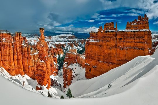
Hoodoos and a View Beyond at Rainbow Point (Bryce Canyon National Park) by Mark Stevens
Via Flickr:
A setting looking to the north while taking in views across hoodoos and other eroded formations at Rainbow Point in Bryce Canyon National Park. My thought on composing this image was to take advantage of the color contrast between the nearby hoodoos with its reds and oranges along the escarpment edge with that of the greens of the evergreen trees in the lower valley and canyon area. I decided to angle my Nikon SLR camera slightly downward as I felt it better brought out that view to allow the eyes to slowly move across this national park landscape and be drawn into the image.
#Aquarius Plateau#Azimuth 349#Black Butte#Blue Skies#Brian Head#Bryce Canyon#Bryce Canyon National Park#Central Utah Plateaus#Colorado Plateau#Day 4#Desert Landscape#Desert Mountain Landscape#Desert Plant Life#DxO PhotoLab 5 Edited#Eastern Edge of the Paunsaugunt Plateau#Eroded Formations#Evergreen#Evergreens#High Desert#Hoodoos#Horseshoe-shaped Amphitheater#Intermountain West#Landscape#Landscape - Scenery#Layers of Rock#Little Creek Peak#Looking North#Nature#Nikon D850#No People
2 notes
·
View notes
Text
A crash course in some vocabulary
Archaeology, like all sciences, has a lot of specialized jargon we use to talk about pottery. To make sure everyone’s on the same page, here’s a list of some common terms I’ll be using, what they mean, and how to pronounce them.
~ 🏺🏺🏺 ~
Ware: A broader term for a technological/cultural tradition in pottery. Typically, construction method, color, clay type, temper type, and paint type are what defines a “ware.” So Chuska Gray Ware is unslipped, usually unpainted gray clay with crushed black basalt temper. Roosevelt Red Ware is red-slipped clay with sand temper and carbon-based paint. Hohokam Buff Ware is unslipped or cream-slipped buff-colored clay with coarse sand temper, created using a paddle-and-anvil forming method and painted with red paint.
Type: Within a ware, a type is a more narrowly specific decorative style. Roosevelt Red Ware has multiple types within it, such as Salado Red (unpainted red-slipped), Pinto Black-on-red (black paint on the red in a specific radially symmetric interlocked hatched-and-bold pattern), Pinto Polychrome (same decorative style but on a white-slipped interior field), Gila Polychrome (red exterior, white-slipped interior, a usually-broken black band around the rim, black painted designs in a two- or -four-fold symmetry), Tonto Polychrome (bolder and less symmetric black-and-white designs on a red field), Cliff Polychrome, Dinwiddie Polychrome, Nine Mile Polychrome… different stylistic variations on the Roosevelt Red Ware technological/visual core. You can read more about categorizations here.
A note on naming conventions: Pottery in this archaeological tradition tends to have a two-part name: a location where it was first defined and described, and a colorway. Wares tend to be “[Broad location or broad cultural group] [Color] Ware”; types tend to be “[Specific site] [paint color]-on-[clay color].” So within Tusayan White Ware is Flagstaff Black-on-white.
———
Gila: A river in southern Arizona and a bit of New Mexico, and a lizard and a polychrome type named after it. Pronounced hee-la.
Hohokam: An archaeological term for a Native American cultural group that lived in southern Arizona and northern Sonora, defined by traits like red-on-buff pottery, massive canal systems for field irrigation, and platform mounds. It comes from the O'odham-language word huhugham, “ancestors.” They are the ancestors of the modern Tohono O’odham and Akimel O’odham people (it’s a little bit more complicated than that but that’s basically the case.)
Mogollon: An archaeological term for a Native American cultural group from central New Mexico, eastern Arizona, and northern Chihuahua. Most iconic trait is the elaborate range of corrugated and smudged pottery. Named after the Mogollon Rim, the geological formation that marks the edge of the Colorado Plateau and a drastic change in geology and climate in the northern Southwest and the southern Southwest. Along with the Ancestral Pueblo, the Mogollon culture are ancestors of modern southern Rio Grande and Zuni pueblos. Pronounced moh-guh-yon.
Olla: A water jar with a wide body and narrow neck. Pronounced oy-ya.
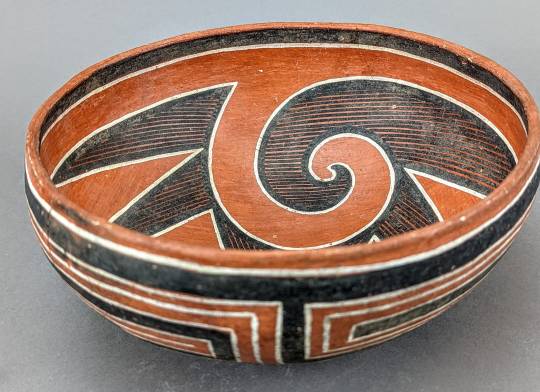
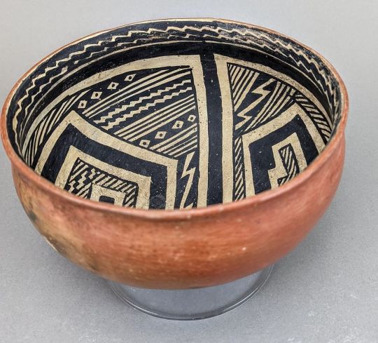
Polychrome: Pottery that is three or more colors (poly+chrome), most often meaning red, white, and black.
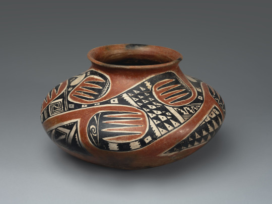
A Tonto Polychrome olla. Southeastern Arizona, 1350-1450.
Pueblo: A collective term for Native people of the Southwest US (particularly in the Rio Grande river watershed, but also Hopi and Zuni) who share cultural traits and history—most immediately notably, a tradition of living in square adobe houses in large villages, which are also each called pueblos. Ancestral Pueblo is the term for the archaeologically-defined cultural group that share these similar traits and are, generally, from the northern half of New Mexico and Arizona, and a southern strip of Colorado and Utah. The Ancestral Puebloans were formerly called “Anasazi” but that has fallen out of favor due to pushback from modern Pueblos. Also, each modern Pueblo prefers to be called a Pueblo rather than a tribe in most cases—so you say the Pueblo of Acoma, the Pueblo of Ohkay Owingeh, Picuris Pueblo, Taos Pueblo, the Pueblo of Zuni, etc.
Temper: Non-clay bits that are added to natural clays to make them easier to work with. When you buy clay from a store now, it’s already mixed and processed and ready to use. When you find clay out in nature, it’s almost never so easy. Typically, you have to mine/harvest clay from riverbanks or cliffsides, and it’s hard and dried; then you have to grind the hard clay up into fine particles, and mix them with water. But natural clays are often puddly and don’t always hold together well, so you add temper, something hard and grainy to make your wet clay stick together more easily and make it good to work with! Temper can be sand, ground-up rock, ground-up shell, or even ground-up bits of other broken pottery. What different people used as temper is one defining feature of a pottery ware and pottery tradition.
Sherd: A broken bit of pottery. NOT shard. When it’s pottery, it’s “sherd.”
Slip: Very runny wet clay. It’s used to help attach clay pieces together, but more pertinently here, plain-colored pots are covered with an even layer of bolder-colored clay slip to get the desired color pot.
Smudging: A decorative style that potters made during the firing stage. They would have open pit-fires for firing their pottery, and cover the desired part of the pot with a layer of charcoal or ash. This creates a carbonized, reducing environment—that is, a lot of carbon, and little oxygen. This creates a smooth, inky black finish on the completed pot.
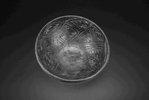
A Starkweather Smudged bowl. Mogollon, western New Mexico, AD 900-1200.
Vessel: Another word for pot, basically. Means a ceramic container of some sort. Bowls, jars, ladles, pitchers, mugs, etc are all vessels; effigies and statuettes are not.
42 notes
·
View notes
Text
grabs dsmp fans by the shoulders utah is not just desert.
most of central and northern utah is mountainous. southern utah is the place with the most sandy desert area, and utah as a whole is considered a steppe climate.
if you are writing or drawing about utah and its supposed to be set in wintertime, there should be at least a foot of snow on the ground.
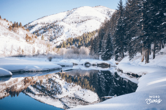
^ like this!
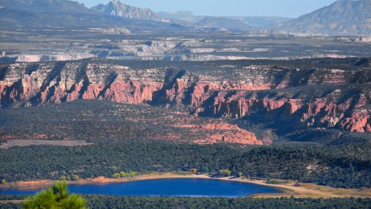
this is southern utah


this is northern utah

this is central utah
some other really beautiful areas:
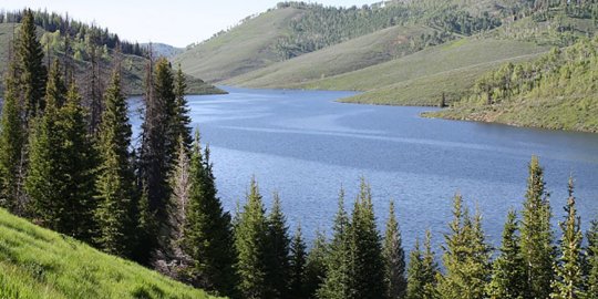
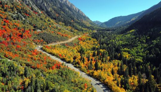

notice how there are forests and mountains all over the place! notice how the deserts are more rocky than sandy!
utah is 84,900 square miles (219,884 square kilometers). to put that in perspective, the entire uk is 94,060 square miles (243,610 square kilometers). it has a very large and varied climate
from the wikipedia article on utah:
"Utah is known for its natural diversity and is home to features ranging from arid deserts with dunes to thriving pine forests in mountain valleys. It is a rugged and geographically diverse state at the convergence of three distinct geological regions: the Rocky Mountains, the Great Basin, and the Colorado Plateau."
please do research on the places you are writing about/drawing i beg of you
#dsmp#utah#wilbur soot#<- bc it is relevant to him#call you tell ive been frustrated by this for a long time#cause i have#nickels talkin
34 notes
·
View notes
Text
Known as the “Trembling Giant,” Pando is more than just your average arbor. Widely considered the world’s largest tree with one vast root system, the aspen clone is also one of the largest living organisms on the planet. Spanning roughly 106 acres within Fishlake National Forest, a sprawling patch of greenery situated in the High Plateaus of south-central Utah, Pando weighs more than 6,600 tons and contains approximately 47,000 genetically identical stems (or branches), experts say.
4 notes
·
View notes
Photo

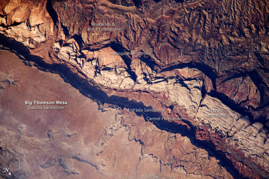
Traces of an Ancient Watery World in Capitol Reef Capitol Reef National Park in south-central Utah is neither home to a capitol, nor a reef. It was named instead for two geologic features: the prominent white domes of Navajo Sandstone, which reminded early settlers of the Capitol Building in Washington, D.C.; and a formidable ridge of rocky cliffs that presented a barrier to travel. The settlers (some likely traveling in prairie schooners) likened it to the maritime navigational hazard of an ocean reef. The ridge, called Waterpocket Fold, runs north-south for 90 miles (140 kilometers). It is visible in the above image, which was acquired on May 2, 2022, by the Operational Land Imager-2 (OLI-2) on Landsat 9. The ridge is named for a common feature in the park. Waterpockets are natural depressions or pockets—eroded from the rock—that collect rainwater and snowmelt, a precious source of freshwater for wildlife and humans in the desert. Geologically, Waterpocket Fold is a monocline, a structure in which the rock layers have been folded up or down on one side. (Structures in which the rock layers are folded on both sides—either bent up like a U-shaped smile or down like frown—are called synclines and anticlines, respectively.) Between 75 million and 35 million years ago, the tectonic forces that uplifted the Rocky Mountains also buckled older rocks below Capitol Reef. The rock layers above did not break, but bent, like a tablecloth draped over a table edge. The bend in this drape forms the Waterpocket Fold. More recently, rains, flash floods, and freeze-thaw cycles have eroded and sculpted the cliffs, canyons, bridges, and domes into what we see today. Capitol Reef tells a geologic story of hundreds of millions of years of deposition, uplift, and erosion—punctuated by episodes of volcanism and glaciation. The park boasts a nearly complete series of rock layers spanning from the late Permian Period (about 290 million years ago) to the end of the Mesozoic Era (66 million years ago). Deposited along and in a shallow sea and ancient delta, these rocks hold a nearly continuous record of life and environments here from before the rise of the dinosaurs through their demise. Today, they are some of the most well-known rocks of the Colorado Plateau, including the Moenkopi, Chinle, Navajo, Entrada, and Dakota formations. Several of these are visible in the below image of Big Thomson Mesa within Capitol Reef. The photograph was taken on June 14, 2009, by the crew on the International Space Station. Capitol Reef also hosts part of the largest and oldest fossil megatracksite in North America. These are mostly trace fossils, or ichnofossils, found in the Moenkopi Formation, which formed in the Early Triassic Period, about 240 million years ago. Unlike body fossils, trace fossils are the marks or other evidence that ancient life left behind—like footprints, burrows, and even feces (coprolites). Many of the trackways at Capitol Reef were formed when fish dragged their fins or reptiles scraped their feet, toes, or claws as they swam along an ancient shoreline or traversed a tidal mudflat. The impressions that they left were later filled with sand, which hardened into sandstone, forming casts. In May 2022, park officials reported the loss of part of a rare fossil trackway. After posting a photo of a rock outcrop on social media, park officials were alerted to the missing tracks by a paleontologist who was familiar with the site. An examination of previous photos of the site revealed the fossils had been removed sometime between August 2017 and August 2018. NASA Earth Observatory image by Lauren Dauphin, using Landsat data from the U.S. Geological Survey. Astronaut photograph ISS020-E-9861 was acquired on June 14, 2009, with a Nikon D3 digital camera fitted with an 800 mm lens, and is provided by the ISS Crew Earth Observations experiment and Image Science & Analysis Laboratory, Johnson Space Center. The image was taken by the Expedition 20 crew . The image in this article has been cropped and enhanced to improve contrast. Lens artifacts have been removed. The International Space Station Program supports the laboratory to help astronauts take pictures of Earth that will be of the greatest value to scientists and the public, and to make those images freely available on the Internet. Additional images taken by astronauts and cosmonauts can be viewed at the NASA/JSC Gateway to Astronaut Photography of Earth. Story by Sara E. Pratt.
2 notes
·
View notes
Text


Pando (Latin for "I spread")] is a clonal organism representing an individual male quaking aspen (Populus tremuloides) that spans 106 acres and is both the largest tree by weight and the largest tree by landmass, and is also the largest known aspen clone. Pando was identified as a single living organism because each of its stems possess identical genetic markers. Each of its estimated 47,000 stems (ramets) are generally connected by a massive interconnected root system that coordinates energy production, defense and regeneration across its expanse. Located in the Fremont River Ranger District of the Fishlake National Forest along the transition zone between of the Colorado Plateau and Basin and Range in south-central Utah, United States, Pando lives 0.43 miles west of Fish Lake, the largest natural mountain freshwater lake in Utah.
more on wiki
0 notes
Text
The Setting
Geographical Inspirations for "The Demon of the Well,"
by James B. Hendricks
Like Tolkien’s Middle Earth, the landscape that is the setting for The Demon of the Well may only be found within the confines of a story. But the dramatic landscapes of central Asia, north of Tibet gave me plenty of inspiration for the land that the trader and his companions inhabit. Back in 1979, when China opened Xinjiang – its western province – to the outside world, I learned a lot about this region. The great Tarim Basin, hemmed in by high mountains on three sides holds an ocean of shifting sand dunes called the Taklamakan Desert. Those mountains keep out the rain clouds, so only rivers of ice-melt from the bordering ranges reach its thirsty sands. Nearly all the rivers emerging from the Kunlun Mountains on the Tibetan plateau ultimately disappear into the dunes. Only one of these, the Hotan, is great enough to find its way 250 miles north through the sand dunes to join the waters of the Tarim River, which draws its origins from the Celestial Mountains north of the Taklamakan. The Yarkand River on the eastern fringe of the desert, also joins them there. The desert around which these rivers braid has such a fearsome reputation that few ventured far into it back in the old days. By tradition, it was a place where ‘You can go in, but you can never come out’.
And yet, there are ancient trade routes tracing its edges to the north and south, dotted with equally ancient oasis towns where rivers enter the desolation. These are a few of the myriad trails of the Old Silk Road. For many centuries, traders plied this network of trade routes with loads of silk and nephrite jade, providing inspiration for my protagonist’s occupation. East of the Taklamakan, by the expansive salt flats of Lop Nur, travelers on the southern route would have to make a perilous crossing – the trail there marked by the bones of camels who had perished on the trek. I have read that, according to local tradition, the endless gravel plains of this region are haunted by the ghosts of lost travelers, and that these spirits could be treacherous – finding stragglers in a caravan traveling by night and leading them off to their doom with the spectral sounds of camel bells. Details like this found their way into the pages of The Demon of the Well.
But for the geology of the story’s central focus, we must explore other parts of the world. The eerie wind-carved sandstone ‘goblins’ at the heart of the desert that I depict bear a strong resemblance to the hoodoos of Utah’s Bryce Canyon. Among those weird, sandstone pinnacles are a labyrinth of seemingly dry canyons. In my story at least, drinkable water may be found in these narrow canyon passages, if you know where to dig. But beyond the goblins and their bewildering network of canyons, you reach the strangest place of all.
In Ethiopia’s Afar Triangle region, cradled in a hot, dry desert called the Danakil Depression, is a network of boiling hot springs called Dallol by the Afar people. These saline and sulfur springs are heated by molten magma that long ago rose to the Earth’s surface through layers of salt and other strata laid down by an ancient sea. Its colorful springs and gaseous fumaroles look much like those found in the volcanic caldera of Yellowstone Park, in the western United States. Weird sulfur and salt formations, like those of the Dallol Springs, also surround the Devil’s Springs of my story, and similar gas fumaroles rise in the skies around it. The bright yellow of the sulfurous landscape even informs the appearance of the demon himself, when he is in his conversant aspect. It is fitting that such a powerfully destructive demon would have his home in a desert-bound volcanic caldera, waiting patiently to make his bargain with some passing fool. #demonofthewell
1 note
·
View note
Text
Hohokam anasazi

The introduction of corn allowed the Anasazi to settle in one area. The Anasazi did not make pottery during this period, but they did raise Meso-American corn and squash with dry farming and some flood irrigation. The Ancestral Puebloans made and used baskets as containers some were woven tight enough to hold water. The early Anasazi lived in shallow depressions in the ground covered by a canopy of brush and mud called pithouses. This large mountainous region encompasses the Four Corners area, as well as, other parts of Utah, Arizona, Colorado, and New Mexico.Īrcheologists recognize two major periods in the archeological record of the Anasazi, or Ancestral Puebloans: the Basketmaker and Pueblo. D., the Anasazi settled on a high plateau in an area much different than the rest of the Southwest. Spanish Conquistadors named them Pima and Papago. Early Spanish explorers found the descendants of the Hohokam living in small villages. During the twelve hundreds, the Hohokam abandoned their towns and returned to a hunter and gather existence. The Hohokam came to believe their leaders and priests had lost favor with the plant and the rain spirits. Snaketown was located on the Gila River above where the Gila empties into the Salt River.īetween 11, a prolonged drought led to crop failure, starvation, and violent feuds. The largest Hohokam pueblo, Snaketown, had about a thousand residents living in adobe row houses, some of them two and three stories tall. Besides Mesoamerica, the Hohokam carried on a wide trade network between the Anasazi and the Mogollon. Located between Phoenix and Tucson, the Casa Grande ruins were built by the Hohokam. Hohokam settlements were spread from the Tucson Basin, into the Phoenix area, and as far north as present-day Flagstaff. Some of these canals were up to fifty feet wide and dug with massive organized labor using stone tools (Walker). 300 and 500, the Hohokam constructed over a thousand miles of irrigation canals. Although the Hohokam relied a great deal on hunting and gathering, they were good farmers and water engineers. They built rectangular pithouses and lived in small villages. The Hohokam Indians settled in the Gila and Salt River valleys of southern Arizona around 300 B.C. Despite this, the Mogollon Indians had abandoned the mountains by 1200 A.D. Deer, antelope, and other wild game were plentiful in the Mogollon Mountains. had good soil and abundant moisture for growing maize. The mountainous region where the Mogollon lived between 9 A.D. The use of agricultural plants necessitated moving from pithouses to more permanent villages. The Mogollon Indians were initially hunter-gatherers, but as their civilization advanced, they acquired corn, squash, beans, tobacco, and cotton from Mesoamerica. The Mogollon culture eventually expanded to the southern rim of the Colorado Plateau. The Mogollon (mo-ge-yōn) people occupied mountainous areas of Arizona and New Mexico in approximately 200 B.C. In trade with Mesoamerica, they exchanged turquoise for parrot feathers, copper bells, maize (corn), beans, squash, and cotton (Taylor). To varying degrees, the Anasazi, Hohokam, and Mogollon were influenced by the Indians of central Mexico. Except for dogs and turkeys, these Prehistoric tribes did not have domesticated animals, a system of writing, or the wheel. The Southwest Indians had broad similarities in their cultures, but they had distinct languages and political unity. The names, Mogollon, Hohokam, Anasazi, and later Fremont, were given by archeologists to these Prehistoric Indians. This article on the "Ancient Ones" is based on archeological studies, and is not intended to reflect on the religious beliefs of anyone. None of the religious origin beliefs stand up under the scrutiny of scientific and archeological evidence, but this does not mean the religious beliefs are wrong. The Southwest Pueblo Indians of today are direct decedents of the Prehistoric Indian Cultures that raised corn, irrigated fields, and built massive stone structures in Chaco Canyon and Mesa Verde hundreds of years before the first recorded Europeans even saw North America.Īmerican Indians have their own origin beliefs, just as do Christians, Jews, Moslems, Buddhists, and other religious groups. Corn, beans, and squash become so important in most Indian Cultures that they were known as.The Three Sisters. During the late Archaic Period, corn and then beans and squash provided the means for a settled village lifestyle. and one hundred A.D., the Southwest Indians turned toward agriculture to supplement their food source. Archaic Indians moved with changing seasons and environments, but Anasazi, Mogollon, and Hohokam Indians did not range over the vast distances covered by the big game hunters of the late Pleistocene period or the Archaic Indians.
0 notes
Photo

TASK 036 : GOVERNORS OF THE UNITED STATES
in the united states, a governor serves as the chief executive officer and commander-in-chief in each of the fifty states, functioning as both head of state and head of government therein. as such, governors are responsible for implementing state laws and overseeing the operation of the state executive branch. as state leaders, governors advance and pursue new and revised policies and programs using a variety of tools, among them executive orders, executive budgets, and legislative proposals and vetoes. governors carry out their management and leadership responsibilities and objectives with the support and assistance of department and agency heads, many of whom they are empowered to appoint. a majority of governors have the authority to appoint state court judges as well, in most cases from a list of names submitted by a nominations committee.


the NORTHEASTERN UNITED STATES is a geographical region of the united states. its divisions are new england ( connecticut, maine, massachusetts, new hampshire, rhode island, and vermont ) and the mid-atlantic ( new jersey, new york, and pennsylvania ). although it lacks a unified cultural identity, the northeastern region is the nation's most economically developed, densely populated, and culturally diverse region. of the nation's four census regions, the northeast has the second-largest percentage of residents living in an urban setting ( with 85 percent ) and is home to the nation's largest metropolitan area ( new york city ).
NEW ENGLAND.
CONNECTICUT : laura wilmer ( cate blanchett ), republican, since 2011
MAINE : caitlin westcott ( ellen pompeo ), republican, since 2019
MASSACHUSETTS : felicity benson ( rashida jones ), democrat, since 2015
NEW HAMPSHIRE : christi goode ( reese witherspoon ), democrat, since 2017
RHODE ISLAND : adela sebti ( emmanuelle chriqui ), democrat, since 2015
VERMONT : derick han ( john cho ), democrat, since 2017
MID-ATLANTIC STATES.
NEW JERSEY : shaun russell ( laurence fishburne ), democrat, since 2018
NEW YORK : isabelle andrews ( zoe saldana ), democrat, since 2021
PENNSYLVANIA : violet beck ( rooney mara ), republican, since 2015


the MIDWESTERN UNITED STATES is one of four census regions of the united states census bureau, occupying the north central part of the united states. its divisions are east north central ( illinois, indiana, michigan, ohio, and wisconsin ) and west north central ( iowa, kansas, minnesota, missouri, nebraska, north dakota, and south dakota) ). chicago is the most populous city in the american midwest and the third most populous in the entire country. chicago and its suburbs, called chicagoland, form the region’s largest metropolitan area with 10 million people.
EAST NORTH CENTRAL STATES.
ILLINOIS : tracey marsh ( sally hawkins ), republican, since 2019
INDIANA : garth butler ( justin chambers ), republican, since 2017
MICHIGAN : donna randall ( viola davis ), democrat, since 2019
OHIO : philip tirrell ( donald glover ), democrat, since 2019
WISCONSIN : percy hewitt ( john mulaney ), democrat, since 2019
WEST NORTH CENTRAL STATES.
IOWA : kelly grant ( rachel weisz ), democrat, since 2017
KANSAS : dale garner ( clancy brown ), republican, since 2019
MINNESOTA : sadie lawrence ( winona ryder ), democrat, since 2019
MISSOURI : andrea miller ( michele dockery ), republican, since 2018
NEBRASKA : silas nelson ( sam elliott ), republican, since 2015
NORTH DAKOTA : samuel fulton ( daveed diggs ), democrat, since 2016
SOUTH DAKOTA : alicia atkins ( aja naomi king ), democrat, since 2019


the SOUTHERN UNITED STATES is is a geographic and cultural region of the united states. its divisions are the south atlantic ( delaware, florida, georgia, maryland, north carolina, south carolina, virginia, and west virginia ), east south central ( alabama, kentucky, mississippi, and tennessee ), and west south central ( arkansas, louisiana, oklahoma, and texas ). the south does not precisely coincide with the geographic south of the united states but is commonly defined as including the states that fought for the confederate states of america in the american civil war. the deep south lies entirely within the southeastern corner. the region is known for its culture and history, having developed its own customs, musical styles, and cuisines, which have distinguished it in some ways from the rest of the united states. the southern ethnic heritage is diverse and includes strong european ( mostly english, scotch-irish, scottish, irish, and french ), african, and some native american components.
SOUTH ATLANTIC STATES.
DELAWARE : cornelius bancroft ( michael shannon ), republican, since 2017
FLORIDA : angela valdes ( gina torres ), democrat, since 2019
GEORGIA : gabrielle shaw ( octavia spencer ), democrat, since 2019
MARYLAND : damien park ( daniel dae kim ), democrat, since 2015
NORTH CAROLINA : artie barnes ( sam richardson ), democrat, since 2017
SOUTH CAROLINA : shannon todd ( leslie mann ), republican, since 2017
VIRGINIA : rebekah milton ( julianne moore ), republican, since 2018
WEST VIRGINIA : lori taylor ( helen mccrory ), republican, since 2017
EAST SOUTH CENTRAL STATES.
ALABAMA : maynard gardner ( richard jenkins ), republican, since 2011
KENTUCKY : wilson beaumont ( kevin costner ), republican, since 2019
MISSISSIPPI : julianne hargrave ( amy adams ), republican, since 2012
TENNESSEE : shane montgomery ( andrew lincoln ), republican, since 2019
WEST SOUTH CENTRAL STATES.
ARKANSAS : jason wickham ( eddie redmayne ), republican, since 2015
LOUISIANA : christine robson ( antonia thomas ), republican, since 2016
OKLAHOMA : michele abrams ( lea thompson ), republican, since 2019
TEXAS : lorraine crawford ( kelly reilly ), republican, since 2015


the WESTERN UNITED STATES is the region comprising the westernmost states of the united states. its divisions are the mountain states ( arizona, colorado, idaho, montana, nevada, new mexico, utah, and wyoming ) and the pacific states ( alaska, california, hawaii, oregon, and washington ). as american settlement in the united states expanded westward, the meaning of the term “the west” changed. before about 1800, the crest of the appalachian mountains was seen as the western frontier. the frontier moved westward and eventually the lands west of the mississippi river were considered “the west.” the west contains several major biomes, including arid and semi-arid plateaus and plains, particularly in the american southwest; forested mountains, including two major ranges, the american sierra nevada and rocky mountains; the long coastal shoreline of the american pacific coast; and the rainforests of the pacific northwest.
MOUNTAIN STATES.
ARIZONA : daniel rivera ( alfonso herrera ), democrat, since 2019
COLORADO : wyatt harvey ( forest whitaker ), democrat, since 2015
IDAHO : malcolm jackson ( michael fassbender ), republican, since 2019
MONTANA : omar faraj ( marwan kenzari ), democrat, since 2021
NEVADA : noelle bloomfield ( maya rudolph ), democrat, since 2019
NEW MEXICO : oscar méndez ( diego luna ), democrat, since 2019
UTAH : william daniels ( seth meyers ), republican, since 2021
WYOMING : colleen leighton ( felicity jones ), republican, since 2019
PACIFIC STATES.
ALASKA : veronica filippova ( mila kunis ), republican, since 2018
CALIFORNIA : maria reyes ( salma hayek ), democrat, since 2019
HAWAII : makaio kekoa ( keanu reeves ), democrat, since 2014
OREGON : isadora tyler ( susan sarandon ), democrat, since 2015
WASHINGTON : felix kessler ( jeff goldblum ), democrat, since 2013
8 notes
·
View notes
Text
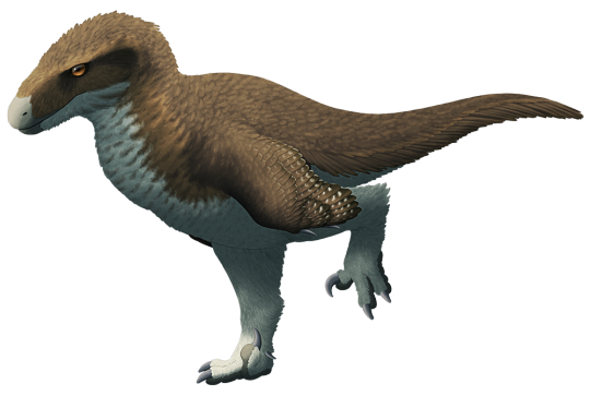
Utahraptor ostrommaysi
By Nix, CC BY-NC 4.0
Etymology: Thief from Utah
First Described By: Kirkland et al., 1993
Classification: Dinosauromorpha, Dinosauriformes, Dracohors, Dinosauria, Saurischia, Eusaurischia, Theropoda, Neotheropoda, Averostra, Tetanurae, Orionides, Avetheropoda, Coelurosauria, Tyrannoraptora, Maniraptoromorpha, Maniraptoriformes, Maniraptora, Pennaraptora, Paraves, Eumaniraptora, Dromaeosauridae, Eudromaeosauria, Dromaeosaurinae
Status: Extinct
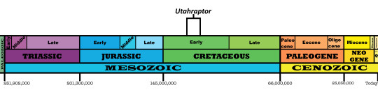
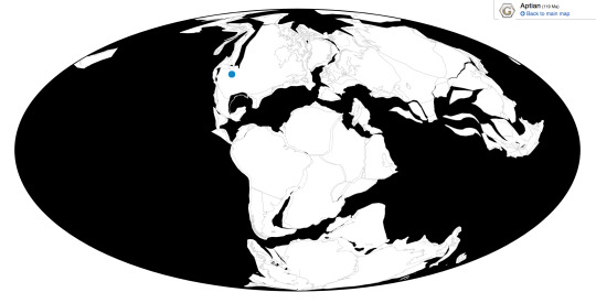
Time and Place: Between 129 and 120 million years go, from the Barremian to the Aptian ages of the Early Cretaceous

Utahraptor is known from the Yellow Cat and Poison Strip members of the Cedar Mountain Formation
Physical Description: Utahraptor was a very large raptor dinosaur, and had the associated bodily characteristics - a bulky trunk, shorter legs, long arms, large head, and long, stiffened tail. It was really and truly huge, about 7 meters long and 500 kilograms in weight - about the size of a modern Grizzley or Polar Bear, though they might have been heavier than previously thought. Like other raptors, it had huge sickle claws on its feet, and the claws were probably around 24 centimeters long - or even longer, if they had been covered in a keratin sheath as potentially thought. The skull of Utahraptor has not yet been described, so for now we can only say that it had a long, triangular head like other raptors, with sharp serrated teeth. As with other raptors, it would have been feathered - with very large wings for flapping, and a distinctively huge tail fan. The legs of Utahraptor would have been slightly less feathered, but still distinctive. In short, it was a big and fluffy bird-bear, and the largest predator in its environment.

By Matt Martyniuk, CC BY-SA 3.0
Diet: Utahraptor was a large predator and, accordingly, ate large sources of food such as ornithopods and younger sauropods.
By PaleoNeolitic, in the Public Domain
Behavior: As a raptor, Utahraptor would have been most analogous to a cat - probably stalking alone rather than in packs, and utilizing ambush behavior to trap its prey. Since it had somewhat stubby legs and wasn’t very fast at all, it couldn’t have relied on pursuit to attack its food, even if its food was just as slow as it was. Instead, these powerful legs helped Utahraptor to jump onto its food and surprise it, even from the ground where it spent its time. It then could use raptor prey restraint (RPR) to stay balanced on the prey, flapping its wings rapidly as the prey moved around and tried to escape. Those impossibly large sickle claws then were used to strategically stab at places where the prey would bleed out - important veins and arteries - rather than slash. In addition to this, Utahraptor would have been able to flap its wings rapidly and run up steep surfaces - a technique called Wing-Assisted Inclined Running (WAIR) - even vertical ones, like cliff faces and trees. This allowed Utahraptor to reach strategic vantage points and search for prey - and even jump down onto it from high heights. These techniques allowed Utahraptor to not only hunt the similarly-sized Ornithopods of the time, but also potentially attack the even larger Sauropods with which it shared its home. When it needed a smaller snack, that large claw could be used to pin down struggling furry mammals and lizards, in order for Utahraptor to then take a bite.
By Fred Wierum, CC By-SA 4.0
Though Utahraptor did not hunt in packs, that doesn’t mean it wasn’t social - and, indeed, there is considerable evidence not yet described that it lived in dense family groups. This would probably mean that adult Utahraptor would go out hunting on their own, while the little ones would gather their own food, before coming together in the same space for safety from other Utahraptor and just to spend the night. It is very likely that Utahraptor took care of its own young based on its relatives - and there’s hopefully more evidence on the way to corroborate this. This was a very complex social animal, using those fancy wings and tail fan to display to other Utahraptor - by holding up the wings and lifting the tail fan to display, it could communicate with others that it was a threat, that it wanted to mate, or to stay away from its nest. In general, it would have behaved very bird-like - walking around, bobbing its head, and moving its head to look for food and for each other rather than moving the eyes. And, like birds, it would have been very active, and warm-blooded.
By Ashley Patch
Ecosystem: When the Cedar Mountain Formation supported Utahraptor, it was a very large floodplain environment, that periodically flash flooded and filled the valley with mud. This was a seasonally wet environment with a variety of rivers, forests, prairies, and open woodlands. The ecosystem had a short wet system and a very long, tedious dry season. Utahraptor shared this environment with countless creatures - the tuataran Toxolophosaurus, the turtle Glyptops, a variety of fish, the mammaliaform Cifelliodon, and - of course - other dinosaurs. There was the ankylosaur Gastonia, the large Iguanodon-like Ornithopods Cedrorestes, Hippodraco, and Iguanacolossus; the Sauropods Cedarosaurus and Mierasaurus; the Therizinosaurs Martharaptor and Falcarius; the Troodontid Geminiraptor; the Ornithomimosaur Nedcolbertia; and another raptor - Yurgovuchia! This gave Utahraptor a wide variety of things to hunt in its environment.
By Emily Willoughby, CC By-SA 3.0
By the time of the later Poison Strip environment, things were changing rapidly in Cedar Mountain. Dry seasons were longer now, and a significant amount of sand was washing through the ecosystem. This made life higher in the floodplain, and probably eliminated many of the forests and river-woods that had been present prior to, leaving only a somewhat scrubland-esque plain. Accordingly, creature diversity actually went down - it was something of an ecosystem collapse. There was still food for Utahraptor to eat - the Ornithopod Planicoxa, and the sauropods Moabosaurus and Venenosaurus; but that was it. Utahraptor, thus, was living in a miniature extinction event - and disappears from the environment by the time the mud and rainy seasons returned in the Ruby Ranch Environment, and the large predator niche was replaced by the carnosaur Acrocanthosaurus.

By Calum O’Halloran
Other: Utahraptor was the largest raptor known, and we actually have many fossils of it - but they’re trapped in a block! Well, there isn’t funding to remove them from the block, anyway. So much more could be (and will be, dammit!) written about this excellent dinosaur if it was adequately funded to be researched properly. Check out the Utahraptor Project if you want to learn more about Utahraptor - and consider donating! Literally every penny helps. Utahraptor is also one of the inspirations for the raptors of Jurassic Park, along with Deinonychus - though, obviously, those creatures do not resemble their real counterparts in the slightest.
~ By Meig Dickson
Sources under the Cut
Apesteguía, S., S. de Valais, G. R. Cordero and O. M. Ramírez. 2011. New ichnological record from the late Campanian Toro Toro Formation at Toro Toro, Potosí (Bolivia): first probably dromaeosaurid tracks from South America. Ameghiniana 48(4):662-667
Aubrey, W.M. 1998. A newly discovered, widespread fluvial facies and unconformity marking the Upper Jurassic/Lower Cretaceous boundary, Colorado Plateau. Modern Geology, v. 22, p. 209-233.
Barco, J. L., and J. I. Ruiz-Omeñaca. 2001. Primeros dientes de terópodo (Dinosauria, Saurischia) en la Formación Villar del Arzobispo (Tithónico-Berriasiense): yacimientos Cuesta Lonsal y Las Cerradicas 2 (Galve, Teruel) [First teeth of a theropod (Dinosauria, Saurischia) in the Villar del Arzobispo Formation (Tithonian–Berriasian): Cuesta Lonsal and Las Cerradicas 2 localities (Galve, Teruel)]. In G. Meléndez, Z. Herrera, G. Delvene & B. Azanza (eds.), XVII Jornadas de la Sociedad Española de Paleontología. Los Fósiles y la Paleogeografía. Ayuntamiento de Albarracín y Fundación Conjunto Paleontólogico de Teruel, Albarracin, Spain 5.1:239-246
Campione, N. E., D. C. Evans, C. M. Brown, M. T. Carrano. 2014. Body mass estimation in non-avian bipeds using a theoretical conversion to quadruped stylopodial proportions. Methods in Ecology and Evolution 5 (9): 913 - 923.
Carpenter, K. 1998. Evidence of predatory behavior by carnivorous dinosaurs. Gaia 15: 135 - 144.
Carpenter, K. 2002. Forelimb biomechanics of nonavian theropod dinosaurs in predation. Senckenbergiana Lethaea 82: 59 - 76.
Carpenter, K., 2006, Assessing dinosaur faunal turnover in the Cedar Mountain Formation (Lower Cretaceous) of eastern Utah, USA. Ninth International Symposium on Mesozoic Terrestrial Ecosystems and Biota, Abstract and Proceedings Volume, p. 21-25.
Carpenter, Kenneth; Bartlett, Jeff; Bird, John; Barrick, Reese (2008). "Ankylosaurs from the Price River Quarries, Cedar Mountain Formation (Lower Cretaceous), east-central Utah". Journal of Vertebrate Paleontology. 28 (4): 1089–1101.
Chure, Daniel; Britt, Brooks; Whitlock, John A.; Wilson, Jeffrey A. (2010). "First complete sauropod dinosaur skull from the Cretaceous of the Americas and the evolution of sauropod dentition". Naturwissenschaften. 97 (4): 379–91.
Cifelli, R. L., Nydam, R. L., Gardner, J. D., Weil, A., Eaton, J. G., Kirkland, J. I., and Madsen, S., 1999, Medial Cretaceous vertebrates from the Cedar Mountain Formation, Emery County, Utah: the Mussentuchit Local Fauna, in, Gillette, D., Vertebrate Paleontology in Utah. Utah Geological Survey Miscellaneous Publication 99-1, p. 219-242.
Britt, B. B., K. L. Stadtman, and R. D. Scheetz. 1996. The Early Cretaceous Dalton Wells dinosaur fauna and the earliest North American titanosaurid sauropod. Journal of Vertebrate Paleontology 16(3, suppl.):24A
Britt, B. B., and K. L. Stadtman. 1997. Dalton Wells Quarry. In P. J. Currie & K. Padian (ed.), Encyclopedia of Dinosaurs 165-166
Britt, B. B., D. A. Eberth, R. D. Scheetz, B. W. Greenhalgh, and K. L. Stadtman. 2009. Taphonomy of debris-flow hosted dinosaur bonebeds at Dalton Wells, Utah (Lower Cretaceous, Cedar Mountain Formation, USA). Palaeogeography, Palaeoclimatology, Palaeoecology 280:1-22
Burnham, D. A., P. Senter, R. Barsbold and B. B. Britt. 2004. Phylogeny of the Dromaeosauridae. Journal of Vertebrate Paleontology 24(3, suppl.):42A
Currie, P. J. 1995. New information on the anatomy and relationships of Dromaeosaurus albertensis (Dinosauria: Theropoda). Journal of Vertebrate Paleontology 15(3):576-591
Currie, P. J. 1997. Dromaeosauridae. In P. J. Currie & K. Padian (ed.), Encyclopedia of Dinosaurs 194-195
Currie, P. J. 2000. Theropods from the Cretaceous of Mongolia. In M. J. Benton, M. A. Shishkin, D. M. Unwin, & E N. Kurichkin (eds.), The Age of Dinosaurs in Russia and Mongolia 434-455
DePalma, R. A., D. A. Burnham, L. D. Martin, P. L. Larson, R. T. Bakker. 2015. The first Giant Raptor (Theropoda: Dromaeosauridae) from the Hell Creek Formation. Paleontological Contributions 14: 1-16.
Dinets, V. 2014. Apparent coordination and collaboration in cooperatively hunting crocodilians. Ethology Ecology & Evolution 27 (2): 244 - 250.
Erickson, G. M., K. Curry Rogers, D. J. Varricchio, M. A. Norell, X. Xu. 2007. Growth patterns in brooding dinosaurs reveals the timing of sexual maturity in non-avian dinosaurs and genesis of the avian condition. Biology Letters 3 (5): 558 - 61.
Fowler, D. W., E. A. Freedman, J. B. Scannella, R. E. Kambic. 2011. The Predatory Ecology of Deinonychus and the Origin of Flapping in Birds. PLoS ONE 6 (12): e28964.
Frederickson, J. A., M. H. Engel, R. L. Cifelli. 2018. Niche Partitioning in Theropod Dinosaurs: Diet and Habitat Preference in Predators from the Uppermost Cedar Mountain Formation (Utah, U.S.A.). Scientific Reports 8: 17872.
Galton, P. M., and J. A. Jensen. 1975. Hypsilophodon and Iguanodon from the Lower Cretaceous of North America. Nature 257:668-669
Gauthier, J., K. Padian. 1985. Phylogenetic, Functional, and Aerodynamic Analyses of the Origin of Birds and their Flight. Hecht, M. K., J. H. Ostrom, G. Viohl, P. Wellnhofer (ed.). The Beginnings of Birds. Proceedings of the International Archaeopteryx Conference, Eichstätt: Freunde des Jura-Museums Eichstätt: 185 - 197.
Gishlick, A. D. 2001. The function of the manus and forelimb of Deinonychus antirrhopus and its importance for the origin of avian flight. In Gauthier, J., L. F. Gall. New Perspectives on the Origin and Early Evolution of Birds. New Haven: Yale Peabody Museum: 301 - 318.
Godefroit, P., P. J. Currie, H. Li, C. Y. Shang, and Z.-M. Dong. 2008. A new species of Velociraptor (Dinosauria: Dromaeosauridae) from the Upper Cretaceous of northern China. Journal of Vertebrate Paleontology 28(2):432-438
Kiernan, K., and D. R. Schwimmer. 2004. First record of a celociraptorine theropod (Tetanurae, Dromaeosauridae) from the eastern Gulf Coastal United States. The Mosasaur 7:89-93
Kirkland, J. I., D. Burge, and R. Gaston. 1993. A large dromaeosaur (Theropoda) from the Lower Cretaceous of eastern Utah. Hunteria 2(10):1-16
Kirkland, J.I., Britt, B., Burge, D., Carpenter, K., Cifelli, R., DeCourten, F., Eaton, J., Hasiotis, S., and Lawton, T., 1997b, Lower to Middle Cretaceous dinosaur faunas of the Central Colorado Plateau: a key to understanding 35 million years of tectonics, sedimentology, evolution, and biogeography. Brigham Young University Geology Studies, v. 42, p. 69-103.
Kirkland, J.I. and Madsen, S.K. (2007). "The Lower Cretaceous Cedar Mountain Formation, eastern Utah: the view up an always interesting learning curve." Fieldtrip Guidebook, Geological Society of America, Rocky Mountain Section. 1-108 p.
Kirkland, J. I., Edward L. Simpson, Donald D. DeBlieux, Scott K. Madsen, Emily Bogner & Neil E. Tibert (2016). Depositional constraints on the Lower Cretaceous Stikes Quarry dinosaur site: Upper Yellow Cat Member, Cedar Mountain Formation, Utah. Palaios 31(9): 421-439; doi: 10.2110/palo.2016.041
Kowallis, B. J., Christiansen, E. H., Deino, A. L., Peterson, F., Turner, C.E., Kunk, M. J., and Obradovich, J. D., 1998, The age of the Morrison Formation. Modern Geology, v. 22, p. 235-260.
Le Loeuff, J., and E. Buffetaut. 1998. A new dromaeosaurid theropod from the Upper Cretaceous of southern France. Oryctos 1:105-112
Longrich, N. R., and P. J. Currie. 2009. A microraptorine (Dinosauria–Dromaeosauridae) from the Late Cretaceous of North America. Proceedings of the National Academy of Sciences
Martyniuk, M. 2016. You’re Doing It Wrong: Microraptor Tails and Mini-Wings. DinoGoss Blog.
McDonald, AT, Kirkland JI, DeBlieux DD, Madsen SK, Cavin J, et al. (2010). Farke AA (ed.). "New Basal Iguanodonts from the Cedar Mountain Formation of Utah and the Evolution of Thumb-Spiked Dinosaurs". PLoS ONE. 5 (11): e14075.
Norell, M. A., and P. J. Makovicky. 2004. Dromaeosauridae. In D. B. Weishampel, P. Dodson, and H. Osmolska (eds.), The Dinosauria (second edition). University of California Press, Berkeley 196-209
Paul, Gregory S. (2016). The Princeton Field Guide to Dinosaurs (2nd Edition). Princeton, New Jersey: Princeton University Press. pp. 151, 163, 229, 252, 314, 319, 326, 327.
Pei, R., Q. Li, Q. Meng, K.-Q. Gao, and M. A. Norell. 2014. A New Specimen of Microraptor (Theropoda: Dromaeosauridae) from the Lower Cretaceous of Western Liaoning, China. American Museum Novitates 3821:1-28
Prum, R.; Brush, A.H. (2002). "The evolutionary origin and diversification of feathers". The Quarterly Review of Biology. 77 (3): 261–295.
Rauhut, O. W. M. 2003. The interrelationships and evolution of basal theropod dinosaurs. Special Papers in Palaeontology 69:1-213
Roca-Argemi, X. and Nadon, G. C. 2003. The Buckhorn Conglomerate as the upper member of the Morrison Formation: new evidence from the type section, Cedar Mountain, Utah. Geological Society of America, Rocky Mountain Section, 55th Annual Meeting, Paper 14-1.
Rothschild, B., Tanke, D. H., and Ford, T. L., 2001, Theropod stress fractures and tendon avulsions as a clue to activity: In: Mesozoic Vertebrate Life, edited by Tanke, D. H., and Carpenter, K., Indiana University Press, p. 331-336.
Ruiz-Omeñaca, J. I., and J. I. Canudo. 2003. Dinosaurios (Saurischia, Ornithischia) en el Barremiense (Cretácico Inferior) de la península Ibérica [Dinosaurs (Saurischia, Ornithischia) in the Barremian (Lower Cretaceous) of the Iberian peninsula]. In F. Pérez Lorente (ed.), Dinosaurios y Otros Reptiles Mesozóicos de España 269-312
Sanders, F.; Manley, K.; Carpenter, K. (2001). "Gastroliths from the Lower Cretaceous sauropod Cedarosaurus weiskopfae". In Tanke, Darren; Carpenter, Ken (eds.). Mesozoic Vertebrate Life: New Research Inspired by the Paleontology of Philip J. Currie. Indiana University Press. pp. 166–180.
Senter, P., R. Barsbold, B. B. Britt and D. A. Burnham. 2004. Systematics and evolution of Dromaeosauridae (Dinosauria, Theropoda). Bulletin of the Gunma Museum of Natural History 8:1-20
Senter, P., J. I. Kirkland, and D. D. DeBlieux. 2012. Martharaptor greenriverensis, a new theropod dinosaur from the Lower Cretaceous of Utah. PLoS ONE 7(8):e43911:1-12
Senter, P.; Kirkland, J.I.; Deblieux, D. D.; Madsen, S.; Toth, N. (2012). Dodson, Peter (ed.). "New Dromaeosaurids (Dinosauria: Theropoda) from the Lower Cretaceous of Utah, and the Evolution of the Dromaeosaurid Tail". PLoS ONE. 7 (5): e36790.
Shapiro, R.S., Fricke, H.C., and Fox, K. 2009. Dinosaur-bearing oncoids from ephemeral lakes of the Lower Cretaceous Cedar Mountain Formation, Utah. Palaios 2(4):51-58.
Smith, D. K. 1997. Museum of Earth Science, Brigham Young University. In P. J. Currie & K. Padian (ed.), Encyclopedia of Dinosaurs 457-458
Stokes, W. L. 1944, Morrison and related deposits in the Colorado Plateau. Geological Society of America Bulletin v. 55, p. 951-992.
Stokes, W.L. 1952. Lower Cretaceous in the Colorado Plateau. American Association of Petroleum Geologists v. 36: 1766-1776.
Sues, H.-D., and A. Averianov. 2014. Dromaeosauridae (Dinosauria: Theropoda) from the Bissekty Formation (Upper Cretaceous: Turonian) of Uzbekistan and the phylogenetic position of Itemirus medullaris Kurzanov, 1976. Cretaceous Research 51:225-240
Switek, Brian (January 7, 2015). "Utah's Dinosaur 'Death Trap' Reveals Trove of Giant Predators". National Geographic. Retrieved April 15, 2017.
Turner, A. H., S. H. Hwang, and M. A. Norell. 2007. A small derived theropod from Öösh, Early Cretaceous, Baykhangor Mongolia. American Museum Novitates 3557:1-27
Turner, Alan H.; Pol, D.; Clarke, J.A.; Erickson, G.M.; Norell, M. (2007). "A basal dromaeosaurid and size evolution preceding avian flight". Science. 317 (5843): 1378–1381.
Turner, AH; Makovicky, PJ; Norell, MA (2007). "Feather quill knobs in the dinosaur Velociraptor". Science. 317 (5845): 1721.
Weishampel, David B.; Dodson, Peter; and Osmólska, Halszka (eds.): The Dinosauria, 2nd, Berkeley: University of California Press. 861 pp.
Williamson, T. E., and S. L. Brusatte. 2014. Small theropod teeth from the Late Cretaceous of the San Juan Basin, northwestern New Mexico and their implications for understanding latest Cretaceous dinosaur evolution. PLoS ONE 9(4):e93190:1-23
Xu, X.; Zhou, Z.; Wang, X.; Kuang, X.; Zhang, F.; Du, X. (2003). "Four-winged dinosaurs from China". Nature. 421 (6921): 335–340.
#Utahraptor ostrommaysi#Utahraptor#Dinosaur#Utahraptor ostrommaysorum#Raptor#Bird#Dromaeosaur#Birds#Feathered Dinosaurs#Dinosaurs#Birblr#Palaeoblr#Factfile#Cretaceous#Carnivore#Theropod Thursday#North America#paleontology#prehistory#prehistoric life#biology#a dinosaur a day#a-dinosaur-a-day#dinosaur of the day#dinosaur-of-the-day#science#nature
710 notes
·
View notes
Video

flickr
Celebrating the Heritage of Our National Parks in Capitol Reef National Park by Mark Stevens
Via Flickr:
While hiking the Chimney Rock Trail with a view looking to the west to the namesake formation in Capitol Reef National Park. I used the high ground I was on to look down on it and perhaps create more of a sense of grandeur.
#Azimuth 266#Blue Skies with Clouds#Capitol Reef National Park#Central Utah Plateaus#Chimney Rock Trail#Colorado Plateau#Day 3#Desert Landscape#Desert Mountain Landscape#Desert Plant Life#DxO PhotoLab 5 Edited#Fish Lake Plateau#High Desert#Highway#Intermountain West#Landscape#Landscape - Scenery#Layers of Rock#Looking West#Monocline#Nature#Navajo Sandstone#Nikon D850#No People#Outside#Partly Cloudy#Project365#Rolling Hillsides#Scenics - Nature#SnapBridge
2 notes
·
View notes
Text
Round 1, Match 1: Northern Polychromes
I call these the "Northern Polychromes" because they are only (in Fourmile's case) or predominantly (in Salado types' case) found in Arizona and New Mexico.
Salado Polychrome
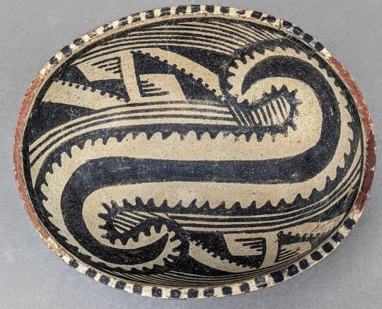
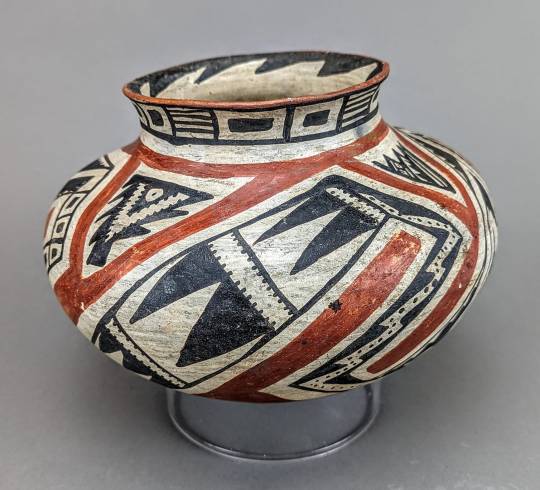
Left, Gila Polychrome oval bowl (AD 1300-1450); Right, Tonto Polychrome olla (AD 1340-1450). Arizona and New Mexico.
vs.
Fourmile Polychrome
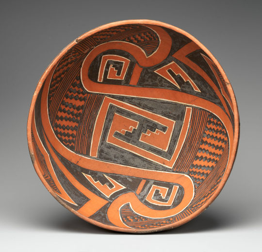
Fourmile Polychrome bowls, AD 1325-1400. Arizona.
More information about each type below the cut:
Salado Polychrome

Cliff Polychrome bowl, southeastern Arizona, AD 1350-1450.
Am I biased because this is what I'm writing my dissertation about so I've been thinking about Salado polys nonstop for about 3 years straight? MAYBE. But that's because they're interesting!
Salado polychrome is a collective name for various black, white, and red types of Roosevelt Red Ware. Pinto, Gila, and Tonto polychrome are the three main types, but there are a lot of described type variants.
Around AD 1275, there was a huge drought that lasted 20 years and impacted the whole Southwest. People moved out of the northern Southwest (Mesa Verde, the Four Corners area, southern Utah, northern Arizona) en masse. If you've ever heard of the "mystery" of the "disappearance" of the Anasazi - it's not a mystery, and they didn't disappear. There was a drought, crop failure, social/political instability, and they moved south to where there were population centers and perennial rivers. Some of these immigrants integrated into pre-existing towns; others formed their own enclave settlements.
And right around this time, a new style of pottery became popular in central/southern Arizona and western New Mexico. Like, really popular. Rapidly widespread, all but replacing the previous black-on-white and red-on-buff painted pottery. Gila polychrome (the most common type of Salado polychrome) is notable for being the most widespread decorated ware in the archaeological Southwest. Why?
Archaeologists debated this for decades upon decades. Were the Salado an immigrant group who brought this ware from the Tonto Basin, from the Sinagua, from the Colorado Plateau, from Mexico? Was it a Hohokam development? Was it Mesoamerican influence? You can read the debates back and forth in the 60s-80s and FEEL the palpable frustration!
Modern scholars basically agree that there's no "Salado" culture, that rather Ancestral Pueblo immigrants from the Kayenta and Tusayan regions of northeastern Arizona developed it after they moved to the south. These Salado polychrome pots weren't centrally made and traded widely, they were predominantly made locally to where they were found. But does it represent a retention/renewal of a Kayenta immigrant diaspora identity, or an integrative ideology that brought together immigrants and locals? And where do the Mesoamerican motifs come from?
I'm arguing more from a Kayenta immigrant diaspora identity marker cohesion-after-migration perspective, but it's a super interesting time of upheaval, reorganization, and social dynamism in the Southwest that really set the stage for the modern Pueblos and tribal groups we know today.
Salado polychromes themselves are defined by a red-slipped exterior, a white field, and black designs on white. The black does not touch the red. The exteriors of bowls are usually left plain red, with all the elaborate decoration on the inside. Sometimes there's so much white you can barely see the red. Two- and four-fold rotational symmetry is common; twinned elements are common, but each twin is usually slightly different from the other, not perfect mirrors. Abstracted representations of feathers and feathered serpents are really common too (the Mesoamerican connection). The black paint is organic, relying on a pigment called beeweed - which may have been sourced from back up in the north, a long way to go but clearly important to the people making these pots!
Fourmile Polychrome

Fourmile Polychrome bowl, AD 1325-1400, central Arizona.
Fourmile Polychrome is a type within White Mountain Red Ware. It's basically contemporaneous with Salado Polychrome, but was made in a different, more northern distribution, by Ancestral Pueblo people who didn't move so far south and congregated around Zuni and east-central Arizona.
Dynamic and bold and more likely to be asymmetrical, Fourmile polychrome is defined by designs in black glaze paint (manganese-based mineral paint with lead in the mix, to make it glossy when it fires and melts) outlined in white.
Both of these types were made by the coil-and-scrape method common to Ancestral (and modern) Pueblo potters (though a small percentage of Salado Polychromes were made by paddle-and-anvil, an argument for the type as an integrative practice...)
24 notes
·
View notes
Text
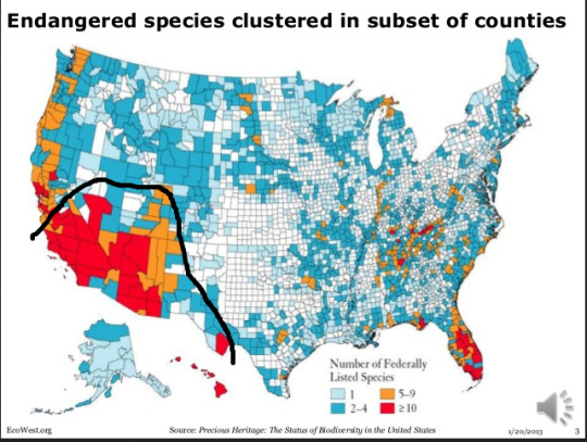
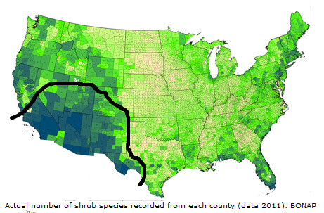
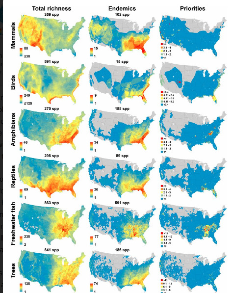
High biodiversity and endemic species distribution range in the deserts of Turtle Island’s “Southwest”:

Sure. Some to start with, which demonstrate high plant biodiversity and endemism in “the deserts” of “the Southwest,” including an obligatory shout-out to a wonderful endemic species of the North American deserts:

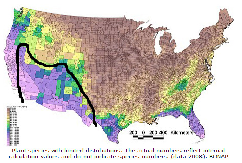


Just to “Situate the Conversation,” some other charismatic endemic species:


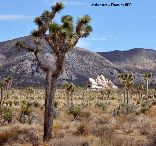
The 3 “true deserts” or “hot deserts” in the region are the Chihuahuan Desert; Sonoran Desert; and Mojave Desert. [This map is a little outdated; the Mojave actually clearly extends into the southwestern corner of Utah, for example.]
And the 3-ish most prominent “cold deserts” or “semideserts” are the Great Basin Desert; Colorado Plateau; and Arizona-New Mexico Plateau. [Map from HARC, using the WWF’s and EPA’s ecoregion standards, which I generally think are pretty good.]

Disclaimer: “Great Basin Desert” is more like semiarid steppe; it receives more moisture in the form of snow, and it’s also characterized mostly by sagebrush steppe, though saltbrush and Lahontan sand playas are also widespread. But, basically, it is contiguous with the nearby true deserts. Also, I personally think it’s useful to split the Great Basin into 2 general regions: (1) the really “desert-y” portion is the Great Basin Desert ecoregion displayed on the map here in green as “Central Basin and Range”, which hosts the majority of saltbrush and salt playas; and (2) then there’s the “northern Great Basin” of the Columbia Plateau and Columbia River watershed (Oregon High Desert and southern Idaho), which is relatively less “desert-y.” Anyway.
-----
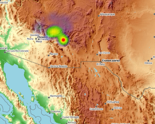
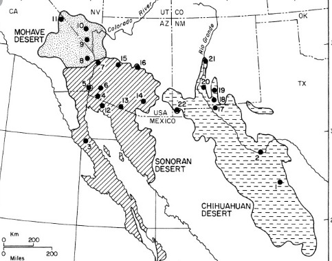
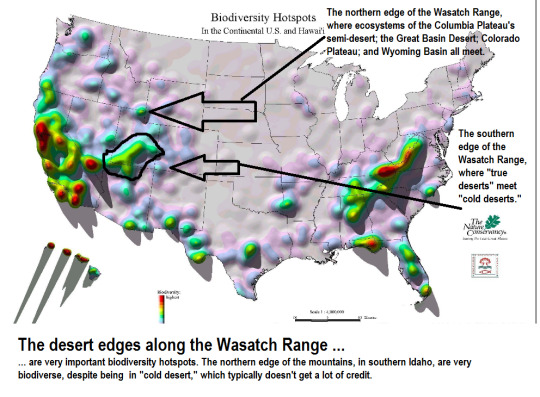
Here’s a look at the Mojave Desert as one of the most prominent regions of concentrated “rare” species. The (1) Colorado Desert; (2) the boundary between the Wasatch Range and the “semi-desert” of the Colorado Plateau; (3) the Sky Islands; and (4) the Chihuahuan Desert also host concentrations of globally-rare small-range species. [From Thom/son Higher Education.]

-----
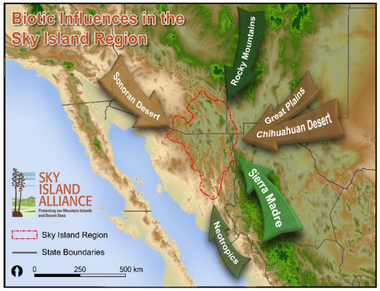
Have to say something about ...
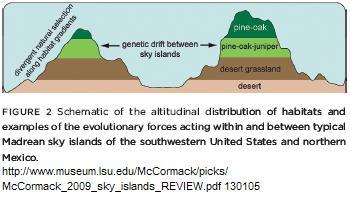
~the Sky Islands~
Even though chaparral of Mediterranean California and temperate rainforest of the Pacific Northwest are arguably 2 of the rarest and most distinct terrestrial biomes on the planet, the Sky Islands still function as one of the top 15-ish most notable biodiversity hotspots on the globe. Here, the Sky Islands are included in a wider ecoregion known as “Madrean pine-oak woodlands.”

The Sky Islands region - at the heart of the “desert” region of North America - is arguably one of the most distinctive biodiversity hotspots on the continent:
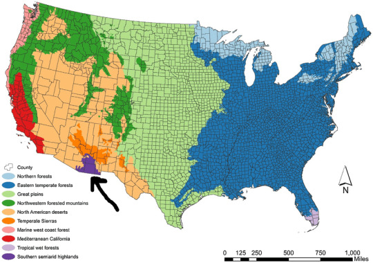
-----

Defenders of W!ldlife, 2018. Map Data Sources: Commission for Environmental Cooperation; Reveal from The Center for Investigative Reporting and OpenStreetMap contributors; The Atlas of Canada, Instituto Nacional de Estadística y Geografía, and USGS
-----


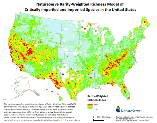
Endemic species ...
Some famous maps of distribution and concentration of endemic species in North America. [I actually have some disagreements with these maps, and how the researchers loosely defined the distinction between an “endemic species” and a “small-ranged species.” For example, the Pacific Northwest hosts more endemic amphibians than is displayed on the maps; the amphibians only live within the narrow marine-influenced coastal temperate rainforest zone, but since the zone stretches across latitudes between Vancouver Island and the Klamath Mountains, the animals aren’t considered “endemic” ... even though they’re clearly endemic to PNW rainforest. But generally, I think they’re great resources and useful maps.]
-----
The Sky Islands (where the Sonoran Desert meets the Chihuahuan Desert) as area of high bird species diversity:

-----
These maps come from a famous 2013 publication:

-----
The “cold deserts” of the northern Great Basin usually get even less attention and credit than hot deserts. But!

110 notes
·
View notes
Text
Red Cliffs and Desert Tortoises
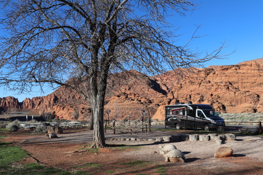

(I can’t believe it’s already been two years since we took this trip. It was featured in the June 2019 issue of Vamoose, but since Southwestern Utah is one of our go-to trips during the spring or fall, I thought I’d post it here. Enjoy!)
Every spring, when we pull the View out of storage, clear the antifreeze out of its water lines, and load up our linens and food, it’s like we’ve come out of hibernation. There’s a sense of rejuvenation and anticipation as we settle into our seats and we get on the road.
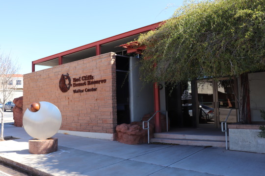
Spring is also the time when the Mojave Desert tortoises ease out of their burrows and start making their way through the red sands of Southwestern Utah and Southeastern Nevada in search of food and mates. While we never saw any in the wild during a trip to Phoenix this past March, we took some time to learn more about them and their habitat by stopping at Red Cliffs Desert Reserve Visitor Center. http://www.redcliffsdesertreserve.com/
I can’t count the times in the past two decades that we’ve driven through St. George and never known of or visited the Center. We were fortunate to catch Outreach Coordinator Lura Snow when we were there, and she introduced us to the three tortoises who make the Center their home: Tank, Shelly, and Sid. Tank is the senior of the three at age 50 and easy to spot in the first exhibit located just inside the interpretive center’s entrance. Shelly and Sid, each around ten years old, were a bit more elusive, but we were able to see them too.
The 62,000-acre reserve was established in 1996 to protect the desert tortoise and other delicate plants and wildlife (including the Gila monster). It is located where three regional ecosystems converge: the Great Basin, Colorado Plateau and Mojave Desert. I encourage you to take a good look at the Reserve’s very informative website (and perhaps download their detailed brochure) before you explore the area.
We spent our first night in Snow Canyon State Park (https://stateparks.utah.gov/parks/snow-canyon/), having caught the last reservation available (unfortunately, it wasn’t Site 19, which is our favorite). The sites are reservable, but they go quickly. There’s a centrally located group site which has a large pavilion with tables. A bank of sites (1-14) in the middle of the campground each have unique lava rock base pavilions and electric and water hookups.
Sites in the north part of the campground do not have hookups, but they are closer to the shower house. A highlight for the kids is a playground near the campground entranceway. It was built in the memory of cyclist Dave Richardson and features stone tortoises, a lizard made of stumps, and a huge rope “spider web.” You can access the playground and day use picnic area from the road.
We arrived late in St. George and were glad that we had a dinner of slow cooker beef stroganoff ready to eat https://www.allrecipes.com/recipe/16352/slow-cooker-beef-stroganoff-i/. When we have a long and steady stretch of road to travel, we often use our slow cooker. We secure it in a plastic milk crate on our dinette bench seat and plug it into a portable inverter that runs off our 12-volt outlet while we’re driving. Just remember to turn the inverter off when the rig is turned off, and turn it on when you get back on the road. It’s really nice after a long day to not have to do a lot of meal prep and if you use a slow cooker liner, it makes clean-up easy, too.
Southern Utah is absolutely vibrant in early spring, and not too hot for navigating the various trails, which are plentiful throughout the Reserve. If we had had the time, I would have loved to have made my way through at least a portion the Turtle Wall trail. Lura told us that we might get lucky and see tortoises along there, but she cautioned us to avoid startling them if we encountered them. If they are caught by surprise, they are easily prone to voiding their bladders which could lead to dehydration or death. So, please navigate the habitat carefully if you happen upon them.
She mentioned that another place to see wildlife in the area is Enterprise Reservoir in Dixie National Forest, where osprey and eagles are often seen.
We took a quick walk starting at the Chuckwalla Trailhead (on Hwy 18, just north of the Red Hills/Snow Canyon Parkway) and found a large group of folks of all ages rock climbing there. It was a Monday morning when we arrived and quite busy for it not being a weekend. One disappointment was the apparent lack of trash receptacles, which is quite problematic when your canine companion does her duty on the trail, so be forewarned.
There are additional state park campgrounds in the area, Sand Hollow (https://stateparks.utah.gov/parks/sand-hollow/) and Quail Creek (https://stateparks.utah.gov/parks/quail-creek/). We’ve been kayaking on both of those reservoirs in the past, but didn’t stop there this time. Instead, I wanted to visit the Red Cliffs Campground (https://www.blm.gov/visit/search-details/202162/1).
Red Cliffs reminded me a lot of Calf Creek Campground. It only has 10 campsites that were all filled by the time we dropped by around mid-afternoon on a Monday. It is a primitive campground – pit toilets and no hookups—but really nice. I love campsites that are inset into the red rock, and this place did not disappoint. We are certainly going to try to find a site there the next time we drive down to this neck of the woods (or rocks).
One important thing to note when going to Red Cliffs Campground is that we just barely navigated two low & narrow underpasses to access it from Old Highway 91. The underpass clearance is only 11’9”. We made it, but just barely. I can see teardrop or tent trailers making their way to the campground more easily. This is not a place for big RVs.
You definitely need to access this campground from Leeds (Exit 23). We found this out the hard way. Old Highway 91 from the south is under repair and not navigable for trailers or RVs. You can make your way from the south if you take Route 9, then SR318 (Quail Creek Road), past Quail Creek Reservoir. But, again, do not try to drive on Old Highway 91 from the south.
There is a KOA Campground (https://koa.com/campgrounds/st-george/) that is just due east of Red Cliffs Campground for larger rigs. Again, if you pull up their website they will tell you to not follow the GPS directions to get to this location. We’ve not stayed there previously but it is rated three stars on Trip Advisor.
The popularity and population of Washington County is booming and there’s a lot of competition for space and access as more people make their way to the area year-round. Plan ahead if you intend to camp, giving yourself plenty of advance time to reserve sites that are reservable, and remember that these habitats are protected for a reason. Tread lightly.
Trip Tip: We love camping in Snow Canyon State Park and with its close proximity to St. George and hookups available, the reservations for it fill up early and quickly. Plan accordingly. Also know that there is no cell service in the park near the campground.
1 note
·
View note
Photo


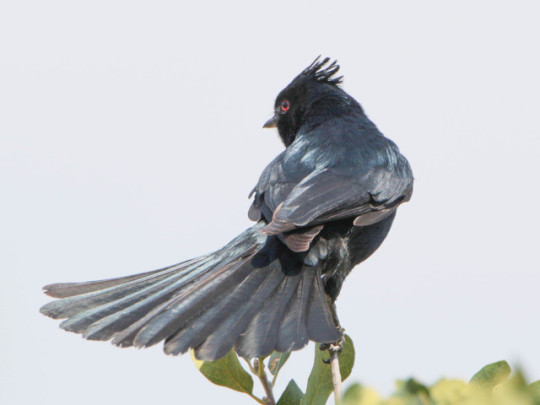

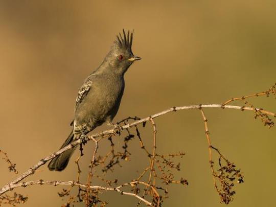


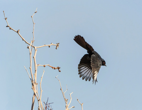

The phainopepla or northern phainopepla (Phainopepla nitens) is the most northerly representative of the mainly tropical Central American family Ptiliogonatidae, the silky flycatchers. Its name is from the Greek phain pepla meaning "shining robe" in reference to the male's plumage. Phainopeplas have been found to imitate the calls of twelve other species, such as the red-tailed hawk and the northern flicker.
The phainopepla is a striking bird, 6.3–7.9 inches long with a noticeable crest and a long tail; it is slender, and has an upright posture when it perches. Its bill is short and slender. The male is glossy black, and has a white wing patch that is visible when it flies; the female is plain gray and has a lighter gray wing patch. Both sexes have red eyes, but these are more noticeable in the female than the male.
The phainopepla ranges as far north as central California and southern Utah, and south to central Mexico, the interior Mexican Plateau region. The southern edge of the plateau, the transverse mountains is its non-breeding home. It is found in hot areas, including desert oases, and is readily seen in the deserts of Arizona, southern Nevada, and southern California. Extreme individuals have travelled as far as Canada, with one bird in 2009 reaching as far north as Brampton, Ontario, Canada.
The phainopepla nests in the spring. The eggs are gray or pink and speckled, and the incubation, done by both the male and female, takes fifteen days. The young will be reared by the parents for up to nineteen more days.
Their diet consists of berries, any small insects, fruits, vegetables. Phainopepla have a specialized mechanism in their gizzard that shucks berry skins off the fruit and packs the skins separately from the rest of the fruit into the intestines for more efficient digestion. So far this is the only known bird able to do this. They appear to relish the fruit of Phoradendron californicum, the desert mistletoe.
103 notes
·
View notes
Text
The Historic National Park Lodge - America's Least Known and Almost Forgotten National Treasure

Take a tour of Americas historic national park lodges.
These crown jewels of the National Park Service are uniquely located in some of the nation's most remote scenic back country. Most of these remarkable landmarks were hand-crafted at or before the turn of the last century. Small armies of old world artisans and craftsmen came together to showcase their remarkable skills in Americas newly formed national parks.
All of these remarkable century old structures are recognized as historic national landmarks for their unique craftsmanship that is unequaled and irreplaceable to this day. Each of them should be preserved, visited and enjoyed by all generations. Lean more Bistate Lodge
No better locations can be found anywhere in North America to experience the vast scenic outdoors. If you enjoy nature or watching endangered wildlife roaming wild and free that are virtually unavailable and inaccessible in their natural setting anywhere else in the country. America's national park lodges and the national parks they reside in are the only place to start your adventure of a lifetime from.
Below you will find a short description of fifteen of Americas premiere historic national park lodges, along with the beautiful national parks they can be found in. If you would like more information, or to read a complete article by Sandra Stacey on any of the listed National Park Lodges herein, please see the resource box following this article.
The Ahwahnee Hotel
Opened in 1927, this magnificent national park lodge is located in what might be America's most beautiful valley. Yosemite Valley is in the heart of Yosemite National Park, California. This renowned park is known the world over for its beauty and striking geologic formations along with its many waterfalls. The luxurious Ahwahnee Hotel sets shaded under towering cliffs and offers guests luxurious accommodations rarely found in a national park setting. Perhaps that's one reason Presidents, world leaders, movie stars, and even Queen Elizabeth II, have graced its halls.
Bryce Canyon Lodge
Opened in 1925,this rustic lodge sets atop a forested Mesa next to the rim of Bryce Canyon in Bryce Canyon National Park, Utah. This is the smallest national park in Utah, but offers visitors the worlds greatest collection of unique geologic formations called Hoodoos. These strange formations, along with many other sight were created by erosion in this small beautiful canyon along the eastern edge of Utah's Paunsaugunt Plateau.
Crater Lake Lodge
Opened in 1915 and rebuilt in 1995, this beautiful national park lodge is scenically perched on the edge of cliffs overlooking Crater Lake. This spectacular deep blue lake is considered by many the most beautiful lake in America. No other lodge anywhere else on earth offers visitors the unique combination of scenic surroundings provided by the collapsed caldera crater in Crater Lake National Park.
The EL Tovar Hotel
Opened in 1905, this architectural wonder seems to spring up out of the very rock it is perched on overlooking the South Rim of the Grand Canyon in Grand Canyon National Park, Arizona. Once called "The most expensively constructed and appointed Log House in America". The El Tovar still holds most of its rustic charm that has attracted many noted guests over the years such as Presidents Roosevelt and Taft, along with Bernard Shaw, Gugliemo Marconi, Author Zane Gray and Albert Einstein.
The Furnace Creek Inn
Opened in 1927, in what is one of the most remote and desolate locations on the North American Continent. Death Valley National Park, California is not the place anyone would normally associate with a lush green oasis of towering Palm trees, or spring-fed gardens. The luxurious Furnace Creek Inn breaks the mold and is certainly one of the most unique lodge destinations you will ever visit. If the beautiful adobe walls could speak, it's not hard to imagine what tales they could tell of the bygone business moguls and Hollywood types that have lounged around the hot spring-fed pools shaded by lush palm trees over the years.
Glacier Park Lodge
Opened in 1913, the guardian to the gates of Glacier National Park, Montana's eastern boundary. This truly grand national park lodge needed a railroad spur laid to the building site just to transport in the enormous timbers that frame its colossal central atrium. When the local Blackfeet Indians first saw the giant timbers unloaded they were so awed by their size that they dubbed the new building "Oom-Coo-Mush-Taw" or "Big Trees Lodge" a fitting name that has stuck ever since.
Grand Canyon Lodge
Opened in 1928, this stunning historic park lodge is posted on a promontory overlooking the North Rim of the Grand Canyon in Grand Canyon National Park, Arizona. If you want to enjoy the Grand Canyon without all the traffic and crowds that gather on the South Rim, make reservations to stay at this stunning remote location on the North Rim.
The Lake McDonald Lodge
Opened in 1914, on the eastern shore of beautiful Lake McDonald deep in the heart of Glacier National Park, Montana, this historic lodge is a prime example and one of the only remaining Swiss Chalet style mountain lodges that early park pioneers strove to create a century earlier. You will be hard pressed to find a more picturesque alpine setting anywhere in North America to enjoy views from the lakeside veranda.
The Many Glacier Hotel
Opened in 1915, this is the largest national park lodge in Glacier National Park, and for many years the largest hotel in Montana. The scenery here is world famous with sweeping panoramic views of Swiftcurrent Lake whose shores this majestic lodge is built along. If you are looking for a vacation destination that offers striking views of the northern Rocky Mountains along with a beautiful pristine alpine lake. You can enjoy it all right from your rooms lake side balcony.
The Old Faithful Inn
Opened in 1904, next to the historic Old Faithful Geyser in the heart of Yellowstone National Park, Wyoming. this is unquestionably the "Queen" of all national park lodges. This massive log structure hardly needs an introduction. It has reigned for well over a century as the largest log building in the world, and has influenced and inspired the construction of all the national park lodges that followed. This was the first national park lodge built anywhere in the world, and Yellowstone National Park was the first designated national park anywhere in the world.
The Oregon Caves Chateau
Opened in 1934, this charming lodge was built to span a wooded granite gorge in the beautiful Siskiyou Mountains next to the entrance to the Oregon Caves in Oregon Caves National Monument, Oregon. You won't want to miss this one if you plan a trip anywhere in the region. A live mountain stream flows through the dining room providing an unforgettable ambiance you won't soon forget.
The Paradise Inn
Opened in 1917, high on the slopes of Mount Rainier in Mount Rainier National Park, Washington, this historic lodge recently went through a massive 35-million dollar restoration. Each stone was numbered and cataloged then completely rebuilt. The term "no stone was left unturned" literally fits in regard to the Paradise Inn. Many notable guests and dignitaries have graced this lodge over the years including President Truman, the crown prince of Norway, Sonja Henie, Tyrone Power, Cecil B. DeMille, and Shirley Temple just to name a few.
Timberline Lodge
Opened in 1937, and has a truly historic past. This national park lodge was built during Americas "Great Depression" as a WPA works project. A small army of out of work master craftsmen and artisans eager for work camped out midway up the slopes of beautiful Mount Hood in the Mount Hood National Forest, Oregon to create this masterpiece. Few lodges anywhere in the world can compete with Timberline Lodge for historic importance, craftsmanship, or overall artistic detail.
The Volcano House
Opened in 1941, on the edge of Kilauea Crater one of the most active volcanoes in the world in Volcanoes National Park, Hawaii. This historic location has been host to some form of structure as far back as the early 1800's. Easily one of the most unique national park lodges you will find anywhere in the world. Not only is Volcano House the only hotel in Volcanoes National Park, it is the oldest continuously operated hotel in Hawaii.
Zion Park Lodge
Opened in 1905, this lodge was uniquely build on the canyon floor in beautiful Zion National Park, Utah. This is an outdoor enthuses dream, set amid a magnificent panoramic surrounding shaded by striking 2000 ft. sandstone cliffs. If you like to hike, backpack, bike ride, or horseback ride you will find this national park lodge an ideal year-round destination.
1 note
·
View note
Last Seen Blogs

tnnrrdchclt
L. 🇳🇬

escapingpurgatorypodcast
ESCAPING PURGATORY PODCAST

dragonknightcal
Dragon Knight's Hoard

44ryder
Book Dragon

summer-time333
Free Palestine!! 🇵🇸