#baray (pools
Text
Apsara Authority Conducts Ceremony Post-Prasat Kork Balang Restoration
Following conservation work at Prasat Kork Balang, Apsara National Authority held a ceremony to honor the site's rejuvenation and safeguard Khmer legacy.
via Khmer Times, 03 February 2024: The Apsara National Authority held a religious ceremony at Prasat Kork Balang in Siem Reap after completing conservation efforts, including bush pruning and water reservoir restoration, to preserve the site’s Khmer heritage and prevent it from being used as a dumping ground.
The Apsara National Authority, together with the local authorities, and the residents…

View On WordPress
0 notes
Photo
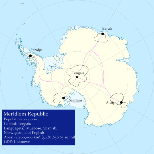
Meridiem Republic
Once Selkie become known to the wider human world, the five major cities assembled to declare themselves the Meridiem Republic, the only country populated primarily by the non-human sophont selkie.
Recognized by the United Nations, Tengais is considered to be the capital and is the most developed moulin throughout the continent. Here, the temperature is akin to that of humid tropical subclimate so vegeation grows in abundance. Structures are in abundance here, built into granite formations which dot the center of the moulin. These structures consist of wood structures from the trees which grow in the moulin along with stacked, carved stone. Roads are paved with flat stones and plumbing is common. Agriculture is present, however, selkie practice a style of agriculture where the crops are integrated into the city and countryside in non intrusive ways. No one family owns these crops but it is good practice to either tend to the plants yourself or to alert someone from the city that a crop needs watering or replanting. Among the many buildings is the Repository, a great library were a record of selkie history resides.
Second in population is Aisimur, considered by Tengais to be a ‘hick’ town despite its booming fish commerce. Aisimur has diminished in population because of intense flooding in the past, leaving old homes carved into the ice abandoned as the city moved further inland. Still, fisherwoman regularly make the trip to the open ocean. Government is very decentralized here and life of a slower tempo than Tengais. The climate is colder than Tengais, being closer to the ocean, and has more temperate flora.
Then comes Saljitam which has the unique feature of having many hot springs. These small pools are ideal for teaching pups to swim and many couples will migrate to Saljitam once their pups are old enough to walk. However, it is effectively run by a male selkie named Lyre who is generally disliked for his ornery temperment and entitled attitude. Not many families stay permanent in Saljitam except if they’re part of Lyre’s harem.
Being the only above ice settlement, Peraljis has a duo population of selkie and leopard seals. The leopard seals regularly use the rocky shores to give birth when the ice floats aren’t avaliable and both species have comes to a truce to refrain from attacking one another. While it is still debated if leopeard seals are sentinent to the same magnitude as selkies, the two species can communicate, albeit cruedly. Among the squat stone settlements is a stone observatory where scholars of astronomy, geography, geology, and meteorology gather to debate a number of topics.
Finally, Barais has the lowest population, with most of the city being flooded in the climate crisis of the mid 21st century. Selkies have just begun to reclaim the moulin and rebuild although progress is slow going.
Interspered between the four great moulins are smaller moulins which are usually inhabitated by one or two families or dedicated to specific tasks such as raising flightless birds or cultivating specific crops.
Humans are tentatively allowed on the continent with a majority of those people being sciencts coming to Antartica for research, primarily in the summer. While there is no immigration quota, humans who move to the Meridiem Republic experience intense culture shock and the importation of foreign flora and fuana is heavily controlled including domesticated pets and livestock.
Infrastructure is centered in the moulins with most of the continent being underdeveloped. On ice infrastructure is heavily regulated and primarily consists of packed ice to form ‘highways’ between the above ground entrances of the moulin alongside human built research stations. Humans typically employ solar powered vehicles to move across the continent or more popularly, sled pulling thylacine who are bred for such a purpose.
Their GDP remains unknown because while selkie in Tengais use oyster shells crafted into small, circular disc (”shells”), a majority of their economy relies on barter economics. They also have a low import and export rate, being highly self reliant though their primary trade partners are Aotearoa, Australia, Agrentina, and Chile.
#Species: Selkie#world: walking whale#spec evo#speculative biology#speculative evolution#worldbuilding#world building
5 notes
·
View notes
Photo
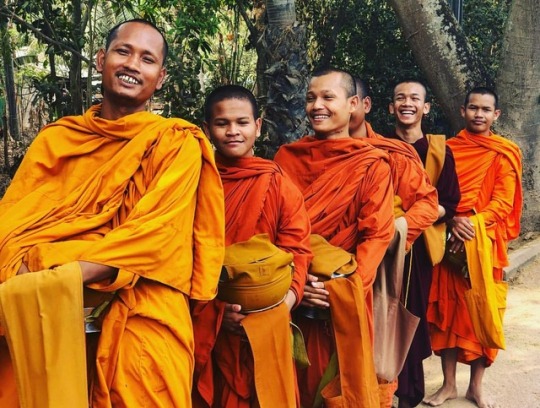
Day 435 Cambodia 🇰🇭 Angkor Wat, Marathon 124. — Run, breakfast, swim, eat some more, nap, and some admin. Spot on. — Marathon 124: Run Report — Hot 35°C with absolutely no breeze to cool me down. A hair dryer in my face the whole time. Even at 06:00am the humidity was crazy. I was dripping wet and covered in sweat within 2 minutes. — My run took me from the glorious Templation Hotel north to Angkor Wat. The worlds most visited tourist attraction. In the south a little way, is the town of Siem Reap and home to the airport of which I’ll sadly be flying out of in a few days. — I ran past 5 key temples today. Angkor Wat, Angkor Thom, Ta Phrom, Neak Péan, and East Baray. — I paid for a 3 day pass at a cost of 62US$ which meant I could also run through and around each area freely. — Bright oranges, tree greens, and deep dark browns were the colour palette for this mornings run. Be it the dust hugging either side of the freshly paved roads, or the old ancient rock of the temples. The views today were something from a film set. Famously Tomb Raider was filmed here and I can see why. — The roads were long, very long, and very straight. I’m certain the stretch that ran north of the Jayatataka lake was the longest straight road I’ve ever ran down. The Sahara Desert doesn’t count. — After I’d turned right and finally right again to complete 3/4 of my loop I was heading south and back to my temporary home @templationsiemreap — A big thanks once again to the brilliant hotel here who allowed me several nights complimentary along with fantastic service and a super luxury villa complete with 2 bathrooms, 4 rooms, huge bed, and a private pool with hot tub. — The pool is all that was on my mind as I headed home. The sun was high in the sky, the shade was fading and my clothes were now leaving a trail of dripping sweat behind me. Some passers by either applauded at my efforts or looked on with confusion and disbelief. Nobody was running or doing any form of exercise at this time of day. This is a very similar feeling if had with folk staring at me in Africa. — #run #runner #running #runnerman #runnerguy #angkorwat #travel #monk #hot #traveller #travelling #worldfirst #cambodia (at Angkor Wat- Templo De Angkor- Siem Reap- Camboya) https://www.instagram.com/p/BvI9LPNngWp/?utm_source=ig_tumblr_share&igshid=1fz6fbs104nyc
#run#runner#running#runnerman#runnerguy#angkorwat#travel#monk#hot#traveller#travelling#worldfirst#cambodia
1 note
·
View note
Link
For many people, the idea of Cambodian architecture begins and ends with the lotus-inspired sandstone towers of Angkor Wat—the medieval temple complex that is considered the largest religious monument in the world. Mid-century modernism, on the other hand? Perhaps not so much.
However, in the 15 years that followed Cambodia’s independence from France in 1953, the capital of Phnom Penh transformed into one of the foremost outposts of modernism—largely thanks to the vision of a single man, architect Vann Molyvann. On September 28, 2017, Molyvann passed away from natural causes in Siem Reap, the gateway to the ruins of Angkor Wat, which had inspired much of his work. But rapid construction and changes in the capital city now mean that Molyvann’s legacy—which already survived coups, purges, and wars, barely—is under threat.
“Before the term ‘green architecture’ was thought in anyone’s mind, he was already designing buildings really creatively to integrate natural light and airflow,” Canadian filmmaker Christopher Rompre, who directed The Man Who Built Cambodia, a 2014 documentary on Molyvann’s life, said in a recent interview with Cambodian magazine Voa Cambodia.
Rompre, who has been based in the Southeast Asian nation for several years, turned his attention to the architect’s work after spotting some “really interesting, unique buildings” that were slowly being enveloped by Phnom Penh’s construction boom. These encounters sparked his curiosity into the work of a lesser-known giant of modernism, a man whose career and vision were deeply entwined with the turbulent history of his country.
“I was trying to understand the origins of the Cambodian people,” Molyvann, then 87, said in the film. “Cambodians have a very spiritual understanding of the world.” After earning his degree from Paris’s École nationale supérieure des Beaux-Arts, where he studied with famed French-Swiss architect Le Corbusier, he returned to his newly independent country during a cultural renaissance that is considered by many to be modern Cambodia’s “Golden Age.” Then-ruler Prince Norodom was eager to let go of the country’s colonial identity and project a modern face to the world. His plans included remaking the appearance of what had been a sleepy provincial capital. He picked 30-year-old Molyvann to do it.
Molyvann served for 13 years as State Architect—1957 to 1970—during which time he worked on nearly 100 projects, including signature creations such as the National Olympic Stadium, the National Theatre, Chaktomuk Conference Hall‚ and the Institute for Foreign Languages. His works represent a unique combination of modernism and elements of the architecture typical of the Khmer Empire, which ruled the country from the eighth to 15th centuries. The style has became known as “New Khmer.”
“This was not inspired by Frank Lloyd Wright, not a European clone, but an authentic style that arose independently in Cambodia,” wrote urban planner Helen Grant Ross, coauthor with Darryl Leon Collins of Building Cambodia: “New Khmer Architecture” 1953–1970, in a recent interview with reporter Ron Gluckman.
As Molyvann himself explains in the film, he wanted to draw from the past to create something entirely new: “Why did I study Le Corbusier? Because he used to built his ‘unites des habitation’ on stilts. Houses on stilts had been existing since prehistoric times in Cambodia. So I only adapted his vocabulary to Khmer architecture.”
Much like Frank Lloyd Wright or Le Corbursier himself, Molyvann’s design process started with an attentive analysis of setting: cardinal position, prevailing winds, and the local rocks, earth, mud, and grass. “The most important is to find what the site suggests,” he says in the film, “what it provokes in the imagination.”
Phnom Penh’s National Olympic Stadium—an ellipitcal, 70,000-seat arena and associated sports complex designed in the early 1960s—is widely considered his signature creation. Moly, as his friends called him, was inspired by the way in which Khmer architects combined earth and water at Angkor Wat. Some 17 million cubic feet of earth were dug out from the site to shape the stadium’s grounds, while an elaborate system of inner canals allowed water to flow from its roof to pools, or barays, at the base—recalling the ancient temples, preventing floods, and keeping crowds cool at the same time. He intended the stadium to be an example of sustainable and accessible architecture that welcomes all for exercise, socializing, or relaxing in the cooled breezes.
The structure was supposed to host the 1963 Southeast Asian Peninsular Games but the competition was never held because of growing political turmoil. In the late 1960s, the kingdom of then-ruler Prince Sihanouk was challenged both by the Communist Party of Kampuchea (CPK), informally known as “Khmer Rouge,” and by his own generals. In 1970, while he was on a state visit to Moscow, the prince was overthrown in a coup led by General Lon Noland. Molyvann, a long-time collaborator and friend of Sihanouk, fled with his wife and kids to Switzerland in the hopes that he could soon return.
But the situation worsened. Civil war broke out between United States–backed Noland and the Viet Cong–supported Khmer Rouge, which eventually seized power in 1975. The new state’s calendar was set to “year zero,” with authoritarian rule and mass executions to follow. For 15 years, Khmer Rouge leader Pol Pot set in motion his plan to “cleanse society from modern elements,” which included the forced displacement of people from cities to the country and the systematic killings of artists and intellectuals. An estimated 1.5 million lost their lives at the hands of his regime.
Pol Pot’s dedication to wiping out modernity and urbanism also took aim at Molyvann’s efforts. All of the materials documenting his works were destroyed, and his buildings were abandoned or converted to military use. The stadium he had so carefully designed as a public resource was used as a site for mass executions.
Molyvann only returned home after the Paris Peace Accords of 1991 ended the Cambodian-Vietnamese War. He found many of his buildings transfigured or deeply neglected. In 1994, during reconstruction efforts, a fire burned down his Preah Suramarit National Theatre, which had just been reestablished as a home for the artists who survived the Khmer Rouge years. It’s charred remains were demolished in 2008.
His creations that weathered those years are now facing an entirely new challenge—Cambodia’s turn back toward urbanism, and the construction craze it has created. Over the past 10 years, the nation’s GDP has doubled, and Phnom Pehn’s population grown nearly four percent a year. New residential blocks are sprouting like mushrooms. The White Building—a residential estate that Molyvann designed with Khmer architectural principles, such as exterior air vents and a partially raised floor to create a shaded social area in the basement—is now being replaced by a Japanese-designed, 21-story mixed-used building. The Council of Ministers building, with a pyramidal shape that recalls Angkor Wat, was replaced in 2008 by a Chinese-designed and -funded building that looks, well, like a contemporary Chinese government office.
The National Stadium remains intact as a place where locals can exercise, conduct business, and socialize day or night, but it had been sold to a Taiwanese developer. The Angkor-inspired drainage system was altered, so now the site frequently floods. This symbol of the New Khmer style also now sits among high-rises and construction cranes.
The problem of recognition and preservation of Molyvann’s creations centers around the fact that they are old enough to be in need of restoration—but not old enough to be considered cultural heritage in a country with such a recognized and significant ancient lineage. As Ross and Collins explain, even French colonial buildings get more international recognition as world heritage than the New Khmer places do. Further, the current government, which came to power in 1979 after defeating the Khmer Rouge, is keen to wipe out any legacy of pre-1979 history.
“The government doesn’t want to leave anything from before 1979, because it wasn’t their achievement. History is completely manipulated,” Molyvann said in a 2010 interview with the Los Angeles Times. Wiping out, by action or neglect, architecture to reshape the country’s identity is a recurrent historical theme—and one that’s not particular to Cambodia.
The father of New Khmer Architecture spent his final years trying to impart his vision to younger generations. “They [young people] should all get together and create New Khmer architecture,” he said with emotion, in one of the last scenes of the film. “No more Vann Molyvann, but a movement of the young.”
The Vann Molyvann Project, started in 2009 by Canadian architect Bill Greaves, is now working to prevent history from interfering with New Khmer architecture yet again. The project calls for Cambodian and international architects to catalog Molyvann’s legacy in paper and digital archives, and through physical models of his buildings. The team also organizes walking tours and records oral histories from people who still inhabit or use the structures.
“We took care of so many things at the Project” says Seng Chanraksmey, a recent architecture graduate from Phnom Penh’s Norton University, who took part in the Vann Molyvann Project in 2015. “I applied because I wanted to know more about his impressive design concept. We were surveying Molyvann’s buildings, making models, interviewing local people for our oral history records.”
Seng is just making her first steps as a professional architect in the booming—and mostly foreign-funded—Phnom Penh construction sector. When asked what is it about New Khmer that inspires her, she goes back to the wellspring of the style. “There are too many things that inspire me about it, but it is especially the will to combine Khmer and Western style to keep the Cambodian identity alive,” she says. “And the message Vann Molyvann left to younger generations: Learn from the past, but do not copy.”
25 notes
·
View notes
Text
Episode 1
Oberoi Mansion. Entrance.
Oberoi Mansion is all lit up for a special occasion. Omkara and Gauri, who are walking in opposite directions, bump into each other, causing some fairy lights to fall on them. Just like they had on Chulbul and Omkara. Omkara looks at her and smiles, but all of a sudden, she becomes distressed.
Gauri: Humein jaana hoga!
Omkara: Kahaan?
Gauri: Iss waqt hum aapke jitna kareeb rahenge, utna hi aapki jaan ko zyaada khatra hoga.
Omkara: Kaisa khatra? Kaunsa khatra? Kis se?
Gauri: Aap ghabraaiye matt. Hum aapko kuch nahi honay denge!
She untangles herself and runs towards the main door, leaving Om tangled behind her.
Omkara: Gauri! Ruko!
Omkara tries to free himself, but he’s stuck. Gauri turns around to face him. She goes back to Omkara and ties a thread around his wrist.
Gauri: Hum sab theek kardeinge. Haath chhoda hai, saath kabhi nahin chhodenge.
Gauri turns away and runs out of the mansion.
Omkara: Gauri!
Omkara’s room. Omkara is lying on the bed in a coma. His vital signs are going crazy, causing a lot of beeping in the room. A flustered Rudra is the only person in the room.
Rudra: Nurse! Nurse!
Omkara gasps for air as if calling out Gauri’s name and opens his eyes. It was all a dream. Rudra holds him and tries to calm him down.
Rudra: O! Aap theek ho! Sab theek hai!
Omkara: Rudra...
The nurse comes in. Rudra steps back and calls Shivaay.
Rudra: Shivaay bhaiyya! Omkara ko hosh aagaya! Aap please jaldi se aa jao!
Jahnvi, Dadi and Bua Maa come running in the room. They can’t believe Omkara is finally better. All of them are extremely emotional, hugging and crying.
Omkara: Mom, Gauri kahan hai?
Bua Maa: Haye naam matt le uska puttar. Usne jo tumhare saath kiya I can never forgive her for that.
Jahnvi: You were right about her, Om. Woh larki dhokebaaz nikli.
Bua Maa: Uss hi ki wajaah se to tera yeh haal hua hai. Laikin koi nai, all’s well that ends well.
Omkara: But Bua Maa kaise? Woh to...
Shivaay comes in with the doctor.
Shivaay: I think behtar yehi hoga if we don’t discuss this right now. You need to focus on getting well first.
Dadi: Haan, Omkara, bas abb tu jaldi se theek hoja.
Shivaay: Doctor?
The doctor nods. Everyone but Shivaay and Rudra leaves the room to let him check Omkara.
Outside the room, a frantic Tej comes running.
Tej: How is he?
Jahnvi: Thoda weak hai, but I think he’ll be fine. Doctor abhi check up kar rahe hain.
Tej: Goddamnit, Jahnvi, I need to see him!
Tej tries to enter the room, but Jahnvi stops him.
Jahnvi: Abhi nahi, Tej. Woh waise hi bohot stressed hai. Main nahi chahti ke tumhe dekh ke uski haalat bigad jaaye.
Tej: He’s my son!
Jahnvi: Laikin woh tumhe abhi baap nahi manta. I can’t believe mujhe tumse yeh kehna padd raha hai, but think logically. Inn 3 maheeno mein tum badle ho, woh nahi.
Tej (sighs): You’re right.
Tej, dejected, steps away from the door.
Omkara’s room.
Shivaay sits on the edge of Omkara’s bed and holds his hand.
Shivaay: You have no idea how glad I am ke tum theek ho. I’ve missed you so much. Inn 3 maheeno mein...
Omkara: 3 maheene? Shivaay, mujhe kuch samajh mein nahi aa raha!
Shivaay: Waqt aane pe main tumhe khud sab samjhaa doonga. But filhaal tum aaraam karo. I don’t want to lose you like this ever again.
Rudra: Haan, O, don’t worry. Picchle 3 maheeno mein jitney bhi jokes crack kiye hain, woh sab aapko sunaoon ga.
They laugh and hug.
Omkara: Rudra?
Rudra: Awkward hogaya?
Omkara: Nahin. Thoda zyada tight hogaya.
He lets go.
Shivaay: Chalein, Dumbbell Singh Oberoi? (to Omkara) I’m so glad tum humare paas waapis aagaye.
Omkara: Kaise jaata? One for all, all for one, remember?
Living room. Everyone’s gathered. The doctor comes towards them.
Shivaay: Om abb kaisa hai, doctor?
Doctor: Woh abb khatre se baahir hai. Thodi weakness hai, laikin kuch dinon mein bilkul theek hojaayenge.
Everybody’s relieved.
Dadi: Bhagwaan ka lakh lakh shukar! Bas abb meray bachon ki zindagi mein aisi koi aafat na aaye!
Bua Maa: Maine to pandit ji se kehke pooja ka intezaam bhi karwa liya hai. Humare ghar ke bachon ko koi buri nazar na lage abb.
Doctor: Yeh kuch medicines hain unki recovery ke liye.
He hands a slip to Tej.
Tej: Yeh sab main personally jaake abhi le aata hoon. We can’t afford to trust anybody with Om’s health right now.
As Tej leaves the room, we see Bua Maa sending a message to someone: “Waqt aagaya hai. Pooja mein koi gadbad nahi honi chahiye.”
Omkara’s room.
Alone in his room, Omkara keeps thinking about the dream. He tries to call Gauri, but her phone isn’t reachable.
Omkara (to himself): Main iss larki ke liye kyun itna pareshaan horaha hoon?
He calls Anika instead.
Anika (emotional): Hello! Omkara! Kaise ho tum?
Omkara (sad): Main theek hoon abb bhabhi. Aapki bohot yaad aarahi hai.
Anika: Kuch hua hai kya? Tum itne pareshaan kyun ho?
Omkara: Pata nai, bhabhi. Sab kuch itna ajeeb sa lag raha hai. Khaali sa... Kya aap mujhse milne aa sakti hain?
Anika (teary): Tumhe dekhne ka bohot mann kar raha hai, Om. Laikin tum to jaante ho na, main Shivaay ke saamne nahi aa sakti... Par tum bilkul matt ghabraao. Shivaay, Rudra aur Gauri koi bhi raita nahi phailne denge. To yeh jo bhi michmichi abhi horahi hai tumhe uspe dehaan matt do.
Omkara: Anika bhabhi, Gau...
Omkara hears someone outside the door.
Omkara: ... Main aapse baad mein baat karta hoon.
He hangs up. Rudra enters the room with a tray.
Rudra: Dekho, O! Aapka favourite... Main! Aur...
He shows Omkara the plate of food on his tray.
Omkara: Rudra, Shivaay kahan hai?
Rudra (jokingly): Shivaay bhaiyya doctor ki report le rahe hai.
Omkara: Woh theek to hai na? Anika bhabhi ke jaane ke baad?
Rudra: Dikhaate to woh yehi hain ke unhe koi farak nahi padta, laikin Annika bhabhi ke jaane ke baad, woh kya, ghar mein koi bhi theek nahi hai.
Shivaay enters the room.
Shivaay: Mere baghair kya baatein horahi hain yahan?
Omkara: Kuch nahi Shivaay, woh bas...
Rudra (absent-mindedly): ... O bhabhi ke baray mein pooch rahay the.
Rudra immediately realizes his slip of tongue and shuts up. Omkara gives him a disapproving look.
Shivaay (unfazed): Oh, Gauri! Humare hotay hue usko kuch nahi ho sakta. Don’t worry, O.
Omkara: Par Gauri hai kahan?
Rudra: Jis din aap coma mein gaye the, Gauri bhabhi mere paas aayi thi...
Flashback.
Gauri (hysterical): Rudy bhaiyya! Aapko kuch bhi karke Omkaraji ko bachaana hoga! Bua Maa Ratan ko paane ke liye har hadd paar kar sakti hain!
Rudra: Bhabhi yeh aap kya bol rahi ho? Ratan to marr chukka hai!
Gauri: Bua Maaji ko lagta hai ke Ratan Omkaraji ke bache ke roop mein waapis aayega. Aur jab woh aayega to... Omkara jaayega.
Rudra: Aisa ho hi nahi sakta. Bua Maa to O se sabse zyada pyaar karti hain! Apna beta maanti hain unko!
Gauri: Yakeen to humein bhi nahi horaha tha. Par jab humne unse kaha ke hum maa nahi bann sakte, to unhone humein apna poora plan harharai ke bataa diya. Humne Omkaraji ko phone (gets teary-eyed)... (wipes her eyes) khair, abb woh humein iss ghar se nikaalna chahti hain, kyunki hum unke kisi kaam ke nahi hain. Aur agar humara shak sahi hai to aaj Omkaraji ke saath jo bhi hua uska saara ilzaam...
Bua Maa (yelling off screen): Gauri!
Rudra (shocked): ... Aap pe lagega.
Oberoi Mansion Entrance
Gauri and Rudra cautiously enter the room. Bua Maa, Jahnvi, Tej and Dadi are standing there, angry and confused.
Gauri: Kya hua Bua Maaji? Omkaraji theek to hojaenge na?
Bua Maa: Wah! What a girl! Khud Omki ka yeh haal karke, humse inti masoomiyat se pooch rahi hai ke woh theek hoga ke nahi! Jaise ke tumhe kuch pata hi nahi hai!
Gauri: Bua Maaji aap hum pe aisa ilzaam kaise lagaa sakti hain? Jab Omkaraji behosh hue, hum to aapke saath pool area mein the!
Bua Maa: Jhoot pe jhoot! Main pool area mein kya karoongi?
Jahnvi: I can’t believe this, Gauri. Uss waqt Bua Maa apne kamre mein baal blow dry kar rahi thi. Maine khud suna.
Dadi: Humne tumhe iss ghar ki bahu maana, itna bharosa kiya. Aur tumne mere potay ke saath... (tears up)
Gauri: Laikin Dadi hum yeh sab kyun karenge?
Tej: To tum kehna kya chahti ho? Ke yeh Omkara ki Bua Maa ne kiya? Uski dadi ne? Maa ne? Ya phir uske apne baap ya bhai ne? Look around you, Gauri. Iss waqt ghar mein sirf yehi log hain. Aur agar tumhe in mein se kisi pe bhi ilzaam lagaana hai, to soch samajh ke lagaana.
Gauri: Hum ilzaam nahi, sirf sach bolenge. Aur sach yehi hai ke...
Shivaay walks in with the police behind him.
Shivaay: Kya sach hai aur kya jhoot, woh police decide karegi. Abb tumhe jo bhi bolna hai, jail jaake unn se bolna.
Gauri: Suboot kya hai humaare khilaaf?
Tej: Suboot bhi mil hi jaayega. Don’t you worry. Take her away!
The police handcuff Gauri and take her outside the Oberoi Mansion.
2 notes
·
View notes
Text
New Lok Geet Kharani by Prashant Paudel
Kharani is a well tuned folk song by Prashant Paudel. The music video features Suman Khatiwoda and Tilochan Paudel. Kharani is a Nepali lok geet by Prashant Paudel which is directed by himself. Kharani music video was edited by Amar Shakya and music video was cinematographed by Basu Baral.
The music of this song is composed by Prashant Paudel and he himself wrote the lyrics of this song. Suman Khatiwoda and Tilochan Paudel have given their pleasing performance for this song. Kharani is a sentimental song. In this music video, you will get to see the pain which is caused by the low economic condition of family. This music video also deliver the message that when ever we are in trouble, we will again drawn in the another pool of troubles. This also shows the love between mother and son. This music video was post production by Bhavana Music Solution. If you are sentimental folk song lover and once you listen this song, you will keep mouthing it.
The music video is released officially online by Music Nepal via Youtube. Hope that you will enjoy this melodic Lok dohori song Kharani.
youtube
Here is the lyrics for the song Kharani:
Budhi vaeu ama tmi
Pugi sakeu assi
Kaslae dosa lagam barai
Karmai khoti vasi
………………………….
Pohor sala chura foreu
Puchheu sindur sir ko
Bidhuwa ko seto pairahan
Man ma poko pirko
Ansu ko mo ansu ko mol
Ankha ma hatena
Manko ghau jhan badheo ghatena
Ama ansu ko mol ankha ma hatena
Man ko ghau jhan badheo ghatena
Avagini raichhau ama
Rainchhau vagya mani
Birmai vai thala parda
Kasle dela pani
Saule deko baule leko
Rin tiramla vani
Tmlae chhodi pardes tira
Aye ama ma ni
Gham le polda gham le polda
Tmro yad auchha
Dako chhodi runa man lauchha ama
Gham le polda gham le polda
Tmro yad auchha
Dako chhodi runa man lauchha ama
Dako chhodi runa man lauchha
………….. ………….. …………………
The post New Lok Geet Kharani by Prashant Paudel appeared first on etcNepal.com.
0 notes
Text
Forgotten metropolis# 7: how Nasa technology uncovered the ‘megacity’ of Angkor
Recent laser examinations have revealed tracings of a vast city accommodation, comparable in sizing to Los Angeles, all over the temples of Angkor in the Cambodian jungle. The ancient Khmer capital was never lost it just got a bit overgrown
Clusters of massive stone yearn cones poke above the dense forest canopy in Cambodia, looks a lot like ancient rocket ships positioned for take-off, their unique silhouettes reflected in the mirror-calm moat below. Tree root tentacles wander along disintegrating cornices, winding their direction around door chassis and suffocating the serene stone faces of smiling god-kings, oblivious to the fact that their empire have all along succumbed to the natural world.
When youre researching the enigmatic synagogues of Angkor, along with the two million other tourists who come here each year, it can still feel like youre unveiling this lost domain for the first time. Whats more difficult to see as you prowl between the ruined websites, each set apart in the extents of the jungle, is that these shrines were once part of the largest, most sprawling city on the planet.
Its a hunch that archaeologists have had for decades, but which was only recently confirmed in astonishing detail by an aerial laser examine, which cut through the foliage for the first time a few years ago to disclose the grid of a enormous urban agreement stretching for miles around the moated complexes. It showed that the ancient Khmer capital, which flourished from the ninth to 15 th centuries, had more in common with Los Angeles than this series of synagogues standing in splendid isolation in the jungle might suggest.
The laser technology has been a total game-changer, says Damian Evans, the Australian archaeologist “whos been” conducting the airborne examining examination at the cole Franaise dExtrme-Orient, working with Cambodian APSARA National Authority and the Ministry of Culture and Fine Arts. Our surveys have exposed the characteristics of a colonization comparable in sizing to LA or Sydney, with an city organize that resembles the kind of dispersed low-density megacity characteristic of the modern world.
Lidar technology unveiled a network of canals and roads that connected the Angkor temple complex. Photograph: Damian Evans/ Cambodian Archaeological Lidar Initiative
For centuries, investigates of Angkor had been preoccupied with the temple compounds themselves, focusing on the religious symbolism of the structures and the cosmological natures depicted in their intricate bas reliefs. And its not hard to see why.
Grander than anything turn left us by Greece or Rome, was the judgement of young French explorer Henri Mouhot, when he firstly stumbled across Angkor Wat in 1858, a complex he described as a rival to[ the temple] of Solomon, made by some ancient Michelangelo. This central temple alone, has been established by King Suryavarman II in the early 12 th century, remains the largest religious complex in the world, four times larger than Vatican City, its five conical towers rising above a 160 -hectare precinct.
As the only enduring formations in the field, it was assumed that the tabernacles must have controlled like medieval walled towns, each inhabited by staff of a few thousand people. Perhaps “theyve been” built by succeeding monarches, as the royal family and their retinue moved from one complex to the next, leaving a series of separate metropolitans speck in all the regions of the grassland, each frontier by a defensive moat.
The tabernacle of Banteay Top Lidar divulged details of additional synagogue websites and occupation areas in the vicinity of this synagogue. Photograph: Damian Evans
The reality, it is about to change, was nothing of the sorting. The laser inspects, conducted in 2012 and 2015, been demonstrated that these sacred walled districts didnt contain much at all. They were instead surrounded by a sprawling metropolitan system, a grid of expressways, streets and canals that spread far into the bordering landscape, reporting an area larger than modern-day Paris. What archaeologists had been studying for generations was simply the equivalent of a European metropolitan with everything erased away except for the churches and cathedrals.
At its pinnacle in the 12 th century, when London had a population of 18,000, Angkor was home to hundreds of thousands, some reckon up to three-quarters of a million people. So what form did this megacity in the rice fields take?
Im reluctant to use the word city, says Evans. Angkor doesnt follow the usual decoration of an ancient walled municipality with a clearly defined shape. Instead, we detected a exceedingly densely populated downtown urban core, extending a zone of 35 -4 0 sq km, which gradually commits course to a kind of agro-urban hinterland. It gradually melts into a nature of neighborhood temples, mixed up with rice fields, grocery garden-varieties and ponds. It was the prototype of modern-day suburban sprawl.
Angkor locator delineate
Thanks to technology were prepared by Nasa, all of this is perhaps reaped from a few hours of helicopter flight, as opposed to generations of hacking through the undergrowth with machetes( while keeping a lookout for landmines ). Shooting a million laser beams every four seconds from the bottom of a helicopter, the lidar technology( which stands for light-headed imaging detection and ranging) stands a kind of virtual deforestation to take place, stripping away the tree canopy to disclose what lies beneath on the forest storey.
The receives were a show. The scanning disclosed a terrain inscribed with a precise system of furrows and embankments, the bones of the city etched into the landscape.
On the field you just see lumps and humps, says Evans, but this aerial view pictures a very sophisticated plan of street networks, strategy neighbourhoods and intricate waterworks. Angkor was a wield of geoengineering on an unparalleled scale.
Any evidence of these regions on the dirt has long since rotted away. In Khmer society, stone was used solely for religious statues, make of enormous obstructs moved here from excavates 30 miles back along specially dug canals( as the wider laser survey discovered last year ). Everything else even the imperial palaces was made of lumber and thatch, with residences invoked up on stilts on top of earthen dunes, designed to keep them above the floodwaters in the rainy season.
Digital terrain prototype of Preah Khan of Kompong Svay, east of Angkor. Photograph: Damian Evans/ Cambodian Archaeological Lidar Initiative
The Khmers mastery over the natural landscape was perhaps their greatest achievement, and the lidar mapping has exposed complex levels of terraforming and irrigate management systems “thats been” way ahead of any other settlement of the era.
Once again, earlier archaeological studies focused on the symbolic persona of ocean in Angkors cosmological order, reading the enormous tank as epitomizes of the mythological oceans bordering Mount Meru, dwelling of the Hindu deities. While the watercourses obviously played a part in the sacred geography of the city, they were fundamentally there to irrigate the rice fields, the source of the territories enormous property. Success in a tropical climate ultimately is highly dependent on the ability to mitigate spate in the summer monsoon and storage enough irrigate to irrigate the fields during dry season something the Khmer sovereigns had clearly mastered.
Residential localities were arranged around thousands of communal rainfall ponds, while the fields were irrigated by a duet of great pools, or barays, the whole arrangement connected via a vast network of canals and canals. The West Baray, which extends five miles by one mile to the west of downtown Angkor, remains the largest hand-cut body of water on soil. Contained by tall earthen dikes, it holds as the spire of the Khmer ability to harness the landscape for its own ends.
Two laser examines divulged suburban sprawl in Angkor. Image: Damian Evans/ Journal of Archaeological Science
But this hydrological virtuosity, Evans and his crew now belief, is also able to have been at root causes of Angkors unfasten, molting new light on the eventual conclude for this magnificent citys decline.
Archaeologists have long speculated on why the Khmer capital descended into wrecking. One ideology is that the city was sacked by a Siamese invasion in 1431, stimulating the rulers and their people to flee en masse to an area near present-day Phnom Penh. But there is little evidence of the kind of colonizations indicative of a mass migration.
Others “re saying that” transition periods from Hinduism to more placid Buddhism, in accordance with the reign of Jayavarman VII, sapped the Angkorian civilisation of its war mongering, monument-building vigor. Yet that conveniently dismisses the murderous stretches of other Buddhist rulers elsewhere in the world at the time. Another tenuous proposition is that the Khmer depleted themselves with all the building jobs and finally collapsed from mausoleum fatigue.
Evans, nonetheless , now believes that environmental influences played a substantial part. Examining at the sedimentary registers, there is evidence of disastrous flooding, he says. In the expansion of Angkor, they had destroyed all of the forests in the watershed, and we have seen disappointments in the water system, discovering that various parts of the network simply broke down. With the entire feudal hierarchy reliant on the successful management of irrigate, a break in the chain could have been enough to motivates a gradual decline.
While it might be seducing to dwell on the colourful vision of a mass exodus, Evans is keen to emphasise that there was no dramatic downfall at all. There is a lot of manifestation for continued vigor in Angkor, he says. When Portuguese traders called in the 16 th century, and French explorers came here in the 19 th century, they encountered communities of several thousand people living in and around the synagogues. It might have disappeared from the awareness of Europeans for a duration, he includes, but Angkor was never a lost municipality. It just got a bit overgrown.
Please share your stories of other lost metropolis throughout history in the comments below. F ollow Guardian Metropolis on Twitter and Facebook to join in the discussion
Read more: www.theguardian.com
The post Forgotten metropolis# 7: how Nasa technology uncovered the ‘megacity’ of Angkor appeared first on vitalmindandbody.com.
from WordPress http://ift.tt/2ztienh
via IFTTT
0 notes
Text
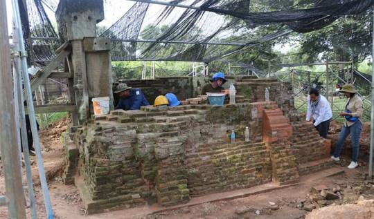
Experts restore the northern tower of Trapeang Lpeou temple
via Khmer Times, 09 August 2023: The Apsara National Authority is restoring the northern tower of Trapeang Lpeou temple after recently completing the southern tower, with plans to restore the central tower later, and expects completion by the end of 2023.
via Khmer Times, 09 August 2023: The Apsara National Authority is restoring the northern tower of Trapeang Lpeou temple after recently completing the southern tower, with plans to restore the central tower later, and expects completion by the end of 2023.
Ratana added that by the beginning of August 2023, the repair process has achieved about 70%. It is planned to be completed by the end of 2023.…
View On WordPress
0 notes
Text
Unearthing Paniat: An Ancient Town with Khmer Culture Remnants in Chanthaburi, Thailand
via Bangkok Post, 03 August 2023: Paniat, an ancient town in the eastern province of Chanthaburi, Thailand, reveals remnants of Khmer culture, indicating historical interactions between Siam and its neighbors.
via Bangkok Post, 03 August 2023: Paniat, an ancient town in the eastern province of Chanthaburi, Thailand, reveals remnants of Khmer culture, indicating historical interactions between Siam and its neighbors.
To the layman, Paniat is unheard of. It is an ancient town that lies in the eastern province of Chanthaburi. It sits at the foot of Khao Sa Bap, a square settlement that was once guarded by…

View On WordPress
#baray (pools#reservoirs#trapieng#etc)#Chanthaburi (province)#Khmer (people)#Underwater Archaeology Division (Thailand)
0 notes
Text
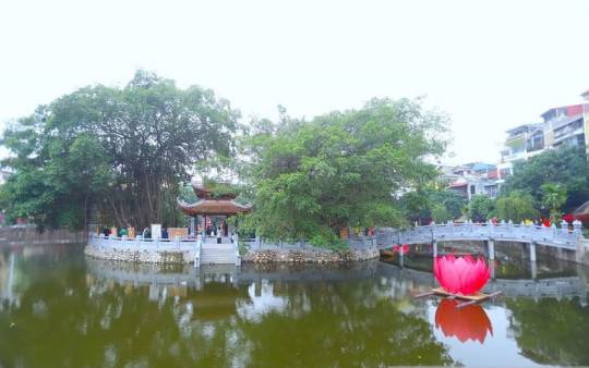
Centuries-long lake in Hanoi gets facelift
via Vietnam Net, 20 March 2023: The newly-renovated Ho Van lake in Hanoi, located in front of the main gate of Hanoi’s famous Temple of Literature. The lake is an integral part of the Temple of Literature relic.
via Vietnam Net, 20 March 2023: The newly-renovated Ho Van lake in Hanoi, located in front of the main gate of Hanoi’s famous Temple of Literature. The lake is an integral part of the Temple of Literature relic.
With the facelift and the special value it boasts, Ho Van, a big lake belonging to the system of the Temple of Literature, is expected to become an appealing cultural-creative space of…
View On WordPress
#baray (pools#reservoirs#trapieng#etc)#Hanoi (city)#restoration / reconstruction#Temple of Literature
0 notes
Text
26 new ancient sites found in Banteay Meanchey province
via Khmer Times, 14 March 2023: 26 new archeological sites were found in Thma Puok district of Banteay Meanchey province, including temples, tombs, kilns, ponds and a baray. #banteaymeanchey #cambodia #archaeology
via Khmer Times, 14 March 2023: 26 new archeological sites were found in Thma Puok district of Banteay Meanchey province, including temples, tombs, kilns, ponds and a baray.
Banteay Meanchey Provincial Department of Culture and Fine Arts has identified 26 new archeological sites in Thma Puok district last week.
Cheng Vanna, deputy director of provincial Department of Culture and Fine Arts, said…

View On WordPress
0 notes
Photo
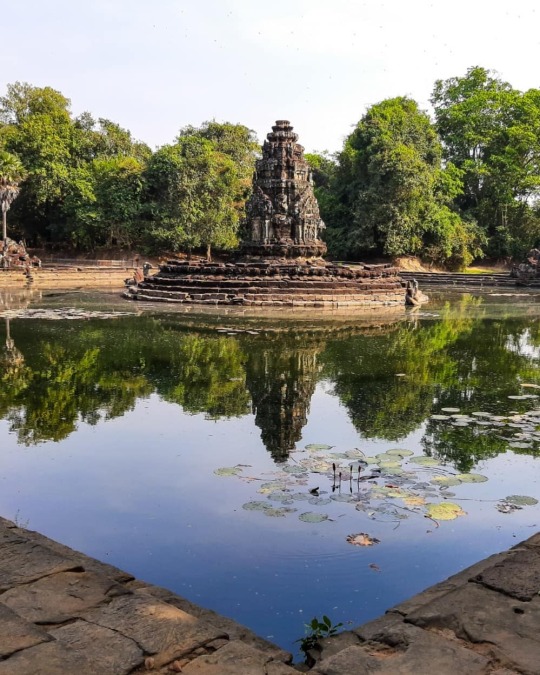
Neak Pean, Architectural structure, Angkor, Cambodia 💯🥳😘📷 Neak Pean (or Neak Poan) (Khmer: ប្រាសាទនាគព័ន្ធ) ("The entwined serpents") at Angkor, Cambodia is an artificial island with a Buddhist temple on a circular island in Jayatataka Baray, which was associated with Preah Khan temple, built during the reign of King Jayavarman VII. It is the "Mebon" of the Preah Khan baray (the "Jayatataka" of the inscription). 🙏🌅🌯 Etymology Some historians believe that Neak Pean represents Anavatapta, a mythical lake in the Himalayas whose waters are thought to cure all illness. The name is derived from the sculptures of snakes (Nāga) running around the base of the temple structure, neak being the Khmer rendering of the Sanskrit naga. "They are Nanda and Upananda, two nagas traditionally associated with Lake Anavatapta." 🤔😊😅 History Neak Pean was originally designed for medical purposes (the ancients believed that going into these pools would balance the elements in the bather, thus curing disease); it is one of the many hospitals that Jayavarman VII built. It is based on the ancient Hindu belief of balance. Four connected pools represent Water, Earth, Fire and Wind. Each is connected to the central water source, the main tank, by a stone conduit "presided over by one of Four Great Animals (maha ajaneya pasu) namely Elephant, Bull, Horse, and Lion, corresponding to the north, east, south, and west quarters. (at Jayatataka) https://www.instagram.com/p/B8LZBv2pB9u/?igshid=1mkc02m5enpzf
0 notes
Text
Forgotten metropolitans# 7: how Nasa technology unveiled the ‘megacity’ of Angkor
Recent laser inspections have disclosed tracings of a immense metropolitan accommodation, comparable in size to Los Angeles, all over the synagogues of Angkor in the Cambodian jungle. The ancient Khmer capital was never lost it just got a bit overgrown
Clusters of giant stone yearn cones poke above the dense forest canopy in Cambodia, looks a lot like ancient rocket ships positioned for take-off, their peculiar silhouettes reflected in the mirror-calm moat below. Tree root tentacles stray along crumbling cornices, winding their channel around doorway chassis and strangling the serene stone faces of smiling god-kings, oblivious given the fact that their empire has long succumbed to the natural world.
When youre investigating the enigmatic synagogues of Angkor, together with the two million other tourists who come here each year, it can still feel like youre unveiling this lost territory for the first time. Whats more difficult to envisage as you wander between the ruined areas, each set apart in the profundities of the jungle, is that these headstones were once part of the largest, most sprawling municipality on the planet.
Its a impression that archaeologists have had for decades, but which was only recently confirmed in astonishing detail by an aerial laser investigation, which cut through the foliage for the first time a few years ago to expose the grid of a vast city settlement pulling for miles all over the moated compounds. It showed that the ancient Khmer capital, which flourished from the ninth to 15 th centuries, had more in common with Los Angeles than this series of tabernacles stand in splendid isolation in the jungle might suggest.
The laser technology has been a total game-changer, replies Damian Evans, the Australian archaeologist who has been contributing the airborne searching survey at the cole Franaise dExtrme-Orient, working with Cambodian APSARA National Authority and the Ministry of Culture and Fine Arts. Our investigations have disclosed the specific characteristics of a settlement comparable in size to LA or Sydney, with an urban formation that resembles the various kinds of scattered low-density megacity characteristic of the modern world.
Lidar engineering discovered a system of canals and roads that connected the Angkor temple complex. Picture: Damian Evans/ Cambodian Archaeological Lidar Initiative
For centuries, expeditions of Angkor had been preoccupied with the temple compounds themselves, focusing on the religious symbolism of such structures and the cosmological macrocosms depicted in their intricate low relief. And its not hard to see why.
Grander than anything left to us by Greece or Rome, was the judgment of young French explorer Henri Mouhot, when he first stumbled across Angkor Wat in 1858, a composite he described as a rival to[ the temple] of Solomon, erected by some ancient Michelangelo. This central temple alone, built by King Suryavarman II in the early 12 th century, remains the largest religion complex in the world, four times larger than Vatican City, five specific conical towers rising above a 160 -hectare precinct.
As the only subsisting designs in the area, it was assumed that the temples must have controlled like medieval walled towns, each inhabited of staff members of a few thousand people. Perhaps they had been built by consecutive lords, as the royal family and their retinue moved from one complex to the next, leaving a series of separate metropolitans scattered in all the regions of the plain, each bordered by a defensive moat.
The synagogue of Banteay Top Lidar disclosed details of additional tabernacle locates and occupation areas in the vicinity of this synagogue. Photograph: Damian Evans
The reality, it is about to change, was nothing of the sort. The laser inspections, conducted in 2012 and 2015, has showed that these sacred walled districts didnt contain much at all. They were instead surrounded by a sprawling urban network, a grid of freeways, streets and canals that provided far into the bordering scenery, embracing an area larger than modern-day Paris. What archaeologists had been studying for generations was simply the equivalent of a European city with everything mopped away except for the churches and cathedrals.
At its pinnacle in the 12 th century, when London had a population of 18,000, Angkor was home to hundreds of thousands, some approximate up to three-quarters of a million people. So what form did this megacity in the rice fields take?
Im reluctant to use the word city, suggests Evans. Angkor doesnt follow the usual structure of an ancient walled metropoli with a clearly defined margin. Instead, we detected a extremely densely populated downtown city core, covering a zone of 35 -4 0 sq km, which gradually yields acces to a kind of agro-urban hinterland. It slowly dissolves into a world-wide of neighborhood shrines, mixed up with rice fields, sell gardens and ponds. It was the prototype of modern-day suburban sprawl.
Angkor locator map
Thanks to engineering devised by Nasa, all of this could be gleaned from a few hours of helicopter flight, as opposed to generations of hacking through the undergrowth with machetes( while keeping a picket for landmines ). Shooting a million laser beams every four seconds from the bottom of a helicopter, the lidar technology( which stands for light-colored likeness detection and ranging) earmarks a kind of virtual deforestation to take place, depriving away the tree canopy to discover what lies beneath on the forest floor.
The discovers were a discovery. The scanning uncovered a terrain inscribed with a precise system of furrows and embankments, the bones of the town etched into the landscape.
On the floor you just see lumps and bulges, suggests Evans, but this aerial view presents a highly sophisticated system of road networks, schemed communities and intricate waterworks. Angkor was a drive of geoengineering on an unparalleled scale.
Any evidence of these neighbourhoods on the soil has long since decomposed away. In Khmer society, stone was used solely for religion shrines, built of enormous cubes floated here from quarries 30 miles back along specially dug canals( as the wider laser survey discovered last year ). Everything else even the imperial palaces was make use of grove and thatch, with dwellings heightened up on stilts on top of earthen dunes, designed to keep them above the floodwaters in the rainy season.
Digital terrain model of Preah Khan of Kompong Svay, east of Angkor. Photograph: Damian Evans/ Cambodian Archaeological Lidar Initiative
The Khmers mastery over the natural landscape was perhaps their greatest achievement, and the lidar mapping has uncovered complex high levels of terraforming and ocean management systems that were way ahead of any other settlement of the era.
Once again, earlier archaeological studies focused on the symbolic role of water in Angkors cosmological order, reading the immense reservoir as epitomizes of the mythological oceans circumventing Mount Meru, residence of the Hindu divinities. While the watercourses apparently played a part in the hallowed geography of the town, they were fundamentally there to irrigate the rice fields, the source of the empires great money. Success in a tropical climate eventually is conditional upon the ability to mitigate flooding during the summer monsoon and accumulation enough water to irrigate the fields during dry season something the Khmer lords had clearly mastered.
Residential regions were arranged around millions of communal rainfall ponds, while the fields were irrigated by a pair of great pools, or barays, the whole system connected by an extensive network of canals and paths. The West Baray, which pulls five miles by one mile to the west of downtown Angkor, remains the largest hand-cut body of water on clay. Contained by towering earthen dikes, it stands as the steeple of the Khmer ability to harness the landscape for its own ends.
Two laser inspections uncovered suburban sprawl in Angkor. Photograph: Damian Evans/ Journal of Archaeological Science
But this hydrological virtuosity, Evans and his squad now speculate, might also have been at the root of Angkors undoing, shedding brand-new light on the eventual conclude for this magnificent metropoli decline.
Archaeologists have long theorized on why the Khmer capital descended into wrecking. One hypothesi is that the city was sacked by a Siamese invasion in 1431, prompting the princes and their people to flee en masse to an province near present-day Phnom Penh. But there is little evidence of the various kinds of agreements indicative of a mass migration.
Others argue that the transition from Hinduism to more serene Buddhism, in accordance with the predominate of Jayavarman VII, sapped the Angkorian civilisation of its war mongering, monument-building vigor. Yet that conveniently discounts the brutal swellings of other Buddhist lords elsewhere in the world at the time. Another tenuous show is that the Khmer depleted themselves with all the building campaigns and finally collapsed from statue fatigue.
Evans, nonetheless , now believes that environmental influences played an important area. Searching at the sedimentary registers, there is evidence of cataclysmic flooding, he remarks. In the expansion of Angkor, they had destroyed all of the woodlands in the watershed, and we have spotcheck downfalls in the water system, exposing that various parts of the network simply are broken down. With the entire feudal hierarchy reliant on the successful management of ocean, a break in the chain could have been enough to spurs a gradual decline.
While it might be inviting to dwell on the colourful vision of a mass exodus, Evans is keen to emphasise that there was no spectacular collapse at all. There was much of attest for continued vigour in Angkor, he replies. When Portuguese merchants inspected in the 16 th century, and French adventurers came here in the 19 th century, they encountered communities of several thousand people living in and all over the tabernacles. It might have disappeared from the consciousness of Europeans for a occasion, he contributes, but Angkor was never a lost metropoli. It just got a bit overgrown.
Please share your legends of other failed cities throughout biography in the comments below. F ollow Guardian City on Twitter and Facebook invited to join such discussions
Read more: www.theguardian.com
The post Forgotten metropolitans# 7: how Nasa technology unveiled the ‘megacity’ of Angkor appeared first on vitalmindandbody.com.
from WordPress http://ift.tt/2wIuRG5
via IFTTT
0 notes
Text
Lost metropolitans# 7: how Nasa technology disclosed the ‘megacity’ of Angkor
Recent laser canvas have discovered marks of a enormous urban village, comparable in width to Los Angeles, all over the temples of Angkor in the Cambodian jungle. The ancient Khmer capital was never lost it just got a bit overgrown
Clusters of gigantic stone pine cones poke above the dense forest canopy in Cambodia, looks a lot like ancient rocket ships poised for take-off, their peculiar silhouettes reflected in the mirror-calm moat below. Tree root tentacles prowl along crumbling cornices, gale their behavior around doorway frames and strangling the serene stone faces of smiling god-kings, oblivious to the fact that their territory has long succumbed to the natural world.
When youre exploring the enigmatic synagogues of Angkor, together with the two million other tourists who come here each year, it can still feel like youre uncovering this lost domain for the first time. Whats more difficult to dream as you stray between the spoilt areas, each set apart in the extents of the jungle, is that these statues were once part of the largest, most sprawling metropoli on the planet.
Its a hunch that archaeologists have had for decades, but which was only recently confirmed in astonishing detail by an aerial laser questionnaire, which cut through the foliage for the first time a few years ago to expose the grid of a enormous urban accommodation straining for miles around the moated complexes. It showed that the ancient Khmer capital, which prospered from the ninth to 15 th centuries, had more in common with Los Angeles than this sequence of temples standing in splendid isolation in the jungle might suggest.
The laser technology has been a total game-changer, remarks Damian Evans, the Australian archaeologist “whos been” guiding the airborne scanning investigation at the cole Franaise dExtrme-Orient, working with Cambodian APSARA National Authority and the Ministry of Culture and Fine Arts. Our examines have revealed the characteristics of a settlement comparable in length to LA or Sydney, with an city figure that resembles the kind of scattered low-density megacity characteristic of the modern world.
Lidar technology uncovered a system of canals and roads that connected the Angkor temple complex. Photo: Damian Evans/ Cambodian Archaeological Lidar Initiative
For centuries, explorations of Angkor had been preoccupied with the temple compounds themselves, focusing on the religious symbolism of such structures and the cosmological natures depicted in their intricate bas reliefs. And its not hard to see why.
Grander than anything turn left us by Greece or Rome, was the judgement of young French explorer Henri Mouhot, when he first stumbled across Angkor Wat in 1858, a complex he described as a rival to[ the temple] of Solomon, erected by some ancient Michelangelo. This central temple alone, built by King Suryavarman II in the early 12 th century, remains the largest religion complex in the world, four times larger than Vatican City, five specific conical towers rising above a 160 -hectare precinct.
As the only enduring organizes in the following areas, it was assumed that the synagogues must have operated like medieval walled towns, each inhabited by staff of a few thousand people. Perhaps “theyve been” has been established by consecutive tycoons, as the royal family and their entourage moved from one complex to the next, leaving a series of detached cities flecked across the plateau, each frontier by a defensive moat.
The tabernacle of Banteay Top Lidar discovered details of additional tabernacle websites and occupation areas in the vicinity of this tabernacle. Photograph: Damian Evans
The reality, it turns out, was nothing of the sorting. The laser examinations, conducted in 2012 and 2015, been demonstrated that these sacred walled precincts didnt contain much at all. They were instead surrounded by a sprawling city network, a grid of boulevards, streets and canals that provided far into the circumventing landscape, including an area larger than modern-day Paris. What archaeologists had been studying for generations was simply the equivalent of a European city with everything mopped away except for the churches and cathedrals.
At its meridian in the 12 th century, when London had a population of 18,000, Angkor was home to hundreds of thousands, some reckon up to three-quarters of a million people. So what form did this megacity in the rice fields take?
Im reluctant to use the word city, supposes Evans. Angkor doesnt follow the usual decoration of an ancient walled metropoli with a clearly defined border. Instead, we detected a exceedingly densely populated downtown city core, considering a zone of 35 -4 0 sq km, which gradually presents mode to a kind of agro-urban hinterland. It slowly terminates into a macrocosm of vicinity shrines, mixed up with rice fields, sell plots and ponds. It was the prototype of modern-day suburban sprawl.
Angkor locator delineate
Thanks to technology developed by Nasa, all of this could be gleaned from a few hours of helicopter flight, as opposed to generations of hacking through the undergrowth with machetes( while keeping a watchman for landmines ). Shooting a million laser beams every four seconds from the bottom of a helicopter, the lidar technology( which stands for light likeness sensing and ranging) permits a kind of virtual deforestation to take place, stripping away the tree canopy to discover what lies beneath on the forest floor.
The observes were a revealing. The scanning disclosed a topography inscribed with a precise system of furrows and knolls, the bones of the city inscribed into the landscape.
On the floor you just see lumps and bumps, articulates Evans, but this aerial view establishes a very sophisticated organisation of road networks, schemed neighbourhoods and intricate waterworks. Angkor was a job of geoengineering on an unparalleled scale.
Any evidence of these neighborhoods on the field has long since decomposed away. In Khmer society, stone was reserved exclusively for religious mausoleums, well-developed of great bricks swum here from quarries 30 miles away along specially dug canals( as the wider laser survey disclosed last year ). Everything else even the royal palaces was make use of grove and thatch, with residences invoked up on stilts on top of earthen hammocks, designed to keep them above the floodwaters in the rainy season.
Digital terrain simulation of Preah Khan of Kompong Svay, east of Angkor. Photograph: Damian Evans/ Cambodian Archaeological Lidar Initiative
The Khmers mastery over the natural landscape was perhaps their greatest achievement, and the lidar mapping has disclosed complex levels of terraforming and liquid management systems that were way ahead of any other settlement of the era.
Once again, earlier archaeological subjects focused on the symbolic capacity of liquid in Angkors cosmological order, reading the vast pool as representations of the mythological oceans circumventing Mount Meru, residence of the Hindu deities. While the watercourses undoubtedly played a part in the sacred geography of the city, they were fundamentally there to irrigate the rice fields, different sources of the territories enormous abundance. Success in a tropical climate eventually depended on the ability to mitigate submerge during the summer monsoon and supermarket enough sea to irrigate the fields during dry season something the Khmer lords is clear that there mastered.
Residential regions were arranged around thousands of communal rainfall ponds, while the fields were irrigated by a pair of enormous pools, or barays, the whole structure connected via an extensive network of canals and paths. The West Baray, which strains five miles by one mile to the west of downtown Angkor, remains the largest hand-cut body of water on globe. Contained by tall earthen dikes, it stands as the steeple of the Khmer ability to harness the landscape for its own ends.
Two laser sketches divulged suburban sprawl in Angkor. Photograph: Damian Evans/ Journal of Archaeological Science
But this hydrological virtuosity, Evans and his crew now imagine, might also have been at the root of Angkors undoing, molting new light on the ultimate ground for this magnificent metropolitan decline.
Archaeologists have long theorized on why the Khmer capital descended into ruining. One theory is that the city was sacked by a Siamese invasion in 1431, inducing the lords and their people to abscond en masse to an arena near present-day Phnom Penh. But there is little evidence of the type of settlements indicative of a mass movement.
Others argue that transition periods from Hinduism to more placid Buddhism, following the predominate of Jayavarman VII, sapped the Angkorian civilisation of its crusade mongering, monument-building verve. Yet that conveniently rejects the murderous stretches of other Buddhist rulers elsewhere in the world at the time. Another tenuous prompting is that the Khmer wearied themselves with all the building assignments and finally collapsed from headstone fatigue.
Evans, however , now am of the opinion that environmental parts played a significant part. Searching at the sedimentary evidences, there is evidence of disastrous flooding, he announces. In the expansion of Angkor, they had destroyed all of the groves in the watershed, and we have seen failures in the water system, discovering that various parts of the network simply are broken down. With the entire feudal hierarchy reliant on the successful management of irrigate, a break in the series could have been enough to motivates a gradual decline.
While it might be seducing to dwell on the colourful vision of a mass exodus, Evans is keen to emphasise that there was no stunning downfall at all. There is a lot of exhibit for continued vigour in Angkor, he replies. When Portuguese brokers inspected in the 16 th century, and French adventurers came here in the 19 th century, they encountered the societies of several thousand people living in and around the synagogues. It might have disappeared from the awareness of Europeans for a meter, he lends, but Angkor was never a lost metropoli. It just got a bit overgrown.
Please share your storeys of other lost cities throughout history in specific comments below. F ollow Guardian Cities on Twitter and Facebook to join in the discussion
Read more: www.theguardian.com
The post Lost metropolitans# 7: how Nasa technology disclosed the ‘megacity’ of Angkor appeared first on vitalmindandbody.com.
from WordPress http://ift.tt/2sWC8V9
via IFTTT
0 notes
Last Seen Blogs

spinjitsuburst
alexa play morro's gay violin theme

zarainshop
Zarain_modestwear

livingintherandom
Living In The Random

pjknoxx
☠︎

limitlesssense
LimitlessTY