#river basin
Photo
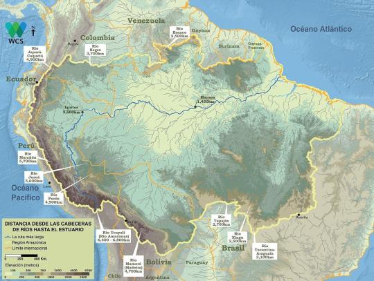
Amazon Basin. Where is the starting point of the Amazon? The Marañón, the Ucayali or their confluence?
122 notes
·
View notes
Text
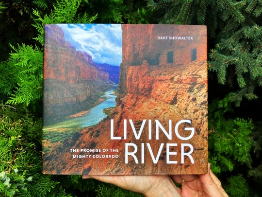

You can find our custom-made Colorado river basin map in conservation photographer Dave Showalter's new book, LIVING RIVER: The Promise of the Mighty Colorado. The book is a remarkable piece of art and an essential read for all the 40 million people who live within the river basin. It explores the endangered Colorado River from source to sea, and illustrates how changing our relationship to water helps make it possible to create a resilient watershed. Additionally, and maybe most importantly, it's a beautiful story about hope and love.
We are proud to be a part of this amazing project. Braidedriver sent us this complimentary copy, and it really is a beautiful book.
LIVING RIVER is not only a book but a multi-year collaborative conservation campaign. We hope to hear more from them in the future and we wish all the best to everyone involved.
You can buy the map as fine art print here.
#geography#maps#cartography#artists on tumblr#my art#river map#colorado#colorado river#living river#river restoration#watersheds#watershed map#colorado watershed#maps reimagined#environmental action#environmental awareness#river basin
26 notes
·
View notes
Text

Above: Lidar-derived image of the Neches River in east Texas, U.S.
19 notes
·
View notes
Text

14 notes
·
View notes
Text
In the East it migrated northward from the area between the Yellow and Yangzi rivers to the Yellow River basin itself, then westward to the Wei River and the region of Qin.
"Why the West Rules – For Now: The patterns of history and what they reveal about the future" - Ian Morris
#book quote#why the west rules – for now#ian morris#nonfiction#china#developed region#migration#yellow river#yangzi river#river basin#wei river#qin#shaanxi
0 notes
Text
Inter-basin reallocation.
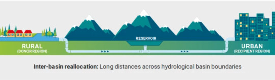
Long distances across hydrological basin boundaries.
#Donor region#recipient region#rural areas#urban areas#water reallocation#Agricultural systems#urban water systems#water flow#municipal water#agricultural water#water reservoir#hydrological basin#river basin
0 notes
Text
A global survey of the rapidly
developing Rights of Nature
jurisprudence pertaining to rivers.
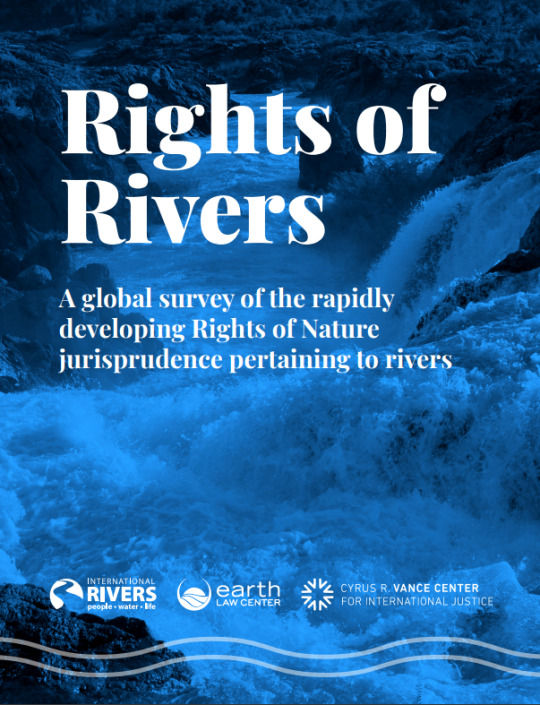
The RIGHTS OF RIVERS report surveys just how these rights are enshrined. In some cases they are grounded in Indigenous jurisprudence and treaty rights. In others, they are enacted as constitutional rights, encoded within national laws, or passed as executive actions. In yet others, they are taken-up in local ordinances in response to federal inaction. The report then examines the efficacy of these approaches to the extent possible, given the newness of these decisions and the relative infancy of the global movement.
0 notes
Photo
In Building River Basin Information System
A river basin is the portion of land drained by a river and its tributaries. Get involved in building a sensible and closer-to-reality river basin information system.
● Share data and information with us at [email protected]
● Volunteer your geospatial skills and subject matter expertise.
● Offer to write content, research and field work.
#River Basin#River Basin Information System#About river system in India#Important of rivers in India#Largest River basin in India
1 note
·
View note
Text
#Legend of Mana#Seiken densetsu 4#Lom#Legend of mana remake#Switch#Nintendo switch#Remaster#Waterfall#Natural bridge#Basin#River#Stream#Waves#Cascade#Cataract#Mine
141 notes
·
View notes
Photo
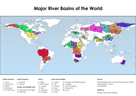
The 26 major river basins of the world
4K notes
·
View notes
Text
Hey All,
I've been away for some time, as we've been working really hard on something quite exciting:
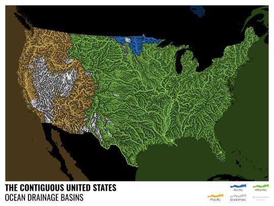
let me present to you the world's first ever global ocean drainage basin map that shows all permanent and temporary water flows on the planet.

This is quite big news, as far as I know this has never been done before. There are hundreds of hours of work in it (with the data + manual work as well) and it's quite a relief that they are all finished now.
But what is an ocean drainage basin map, I hear most of you asking? A couple of years ago I tried to find a map that shows which ocean does each of the world's rivers end up in. I was a bit surprised to see there is no map like that, so I just decided I'll make it myself - as usual :) Well, after realizing all the technical difficulties, I wasn't so surprised any more that it didn't exist. So yeah, it was quite a challenge but I am very happy with the result.
In addition to the global map I've created a set of 43 maps for different countries, states and continents, four versions for each: maps with white and black background, and a version for both with coloured oceans (aka polygons). Here's the global map with polygons:
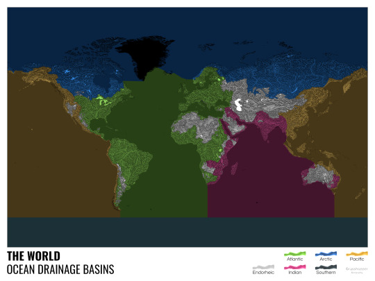
I know from experience that maps can be great conversation starters, and I aim to make maps that are visually striking and can effectively deliver a message. With these ocean drainage basin maps the most important part was to make them easily understandable, so after you have seen one, the others all become effortless to interpret as well. Let me know how I did, I really appreciate any and all kinds of feedback.
Here are a few more from the set, I hope you too learn something new from them. I certainly did, and I am a geographer.
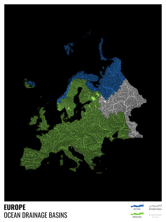
The greatest surprise with Europe is that its biggest river is all grey, as the Volga flows into the Caspian sea, therefore its basin counts as endorheic.
An endorheic basin is one which never reaches the ocean, mostly because it dries out in desert areas or ends up in lakes with no outflow. The biggest endorheic basin is the Caspian’s, but the area of the Great Basin in the US is also a good example of endorheic basins.
I love how the green of the Atlantic Ocean tangles together in the middle.
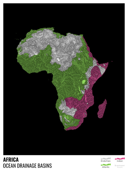
No, the dividing line is not at Cape Town, unfortunately.
I know these two colours weren’t the best choice for colourblind people and I sincerely apologize for that. I’ve been planning to make colourblind-friendly versions of my maps for ages now – still not sure when I get there, but I want you to know that it’s just moved up on my todo-list. A lot further up.
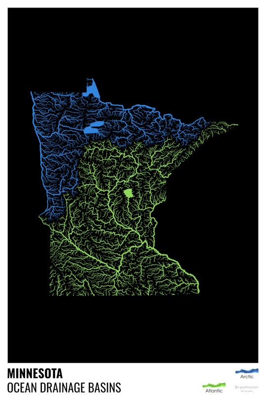
Minnesota is quite crazy with all that blue, right? Some other US states that are equally mind-blowing: North Dakota, New Mexico, Colorado, Wyoming. You can check them all out here.
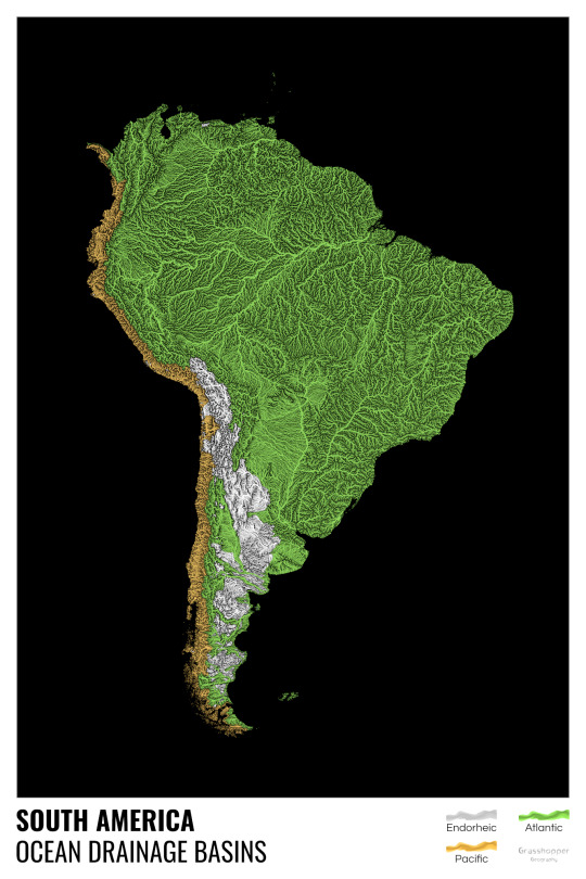
Yes, most of the Peruvian waters drain into the Atlantic Ocean. Here are the maps of Peru, if you want to take a closer look.
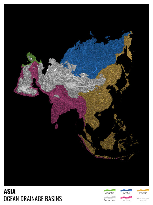
Asia is amazingly colourful with lots of endorheic basins in the middle areas: deserts, the Himalayas and the Caspian sea are to blame. Also note how the Indonesian islands of Java and Sumatra are divided.
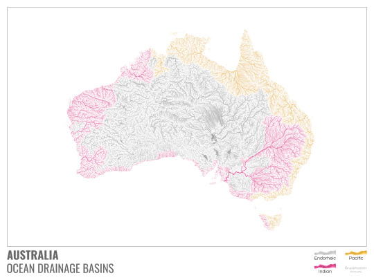
I mentioned earlier that I also made white versions of all maps. Here’s Australia with its vast deserts. If you're wondering about the weird lines in the middle: that’s the Simpson desert with its famous parallel sand dunes.
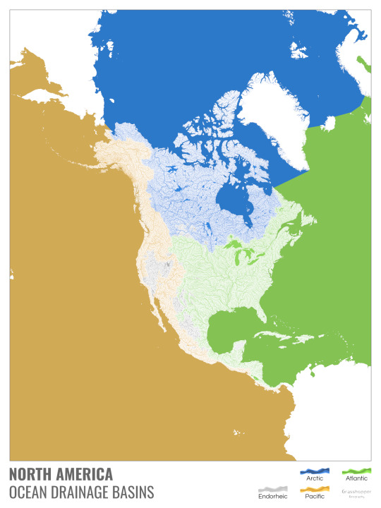
North America with white background and colourful oceans looks pretty neat, I think.

Finally, I made the drainage basin maps of the individual oceans: The Atlantic, the Arctic, the Indian and the Pacific. The Arctic is my favourite one.
I really hope you like my new maps, and that they will become as popular as my river basin maps. Those have already helped dozens of environmental NGOs to illustrate their important messages all around the world. It would be nice if these maps too could find their purpose.
#maps reimagined#geography#cartography#maps#my art#rivers of the world#ocean drainage basins#ocean maps#river maps
16K notes
·
View notes
Photo
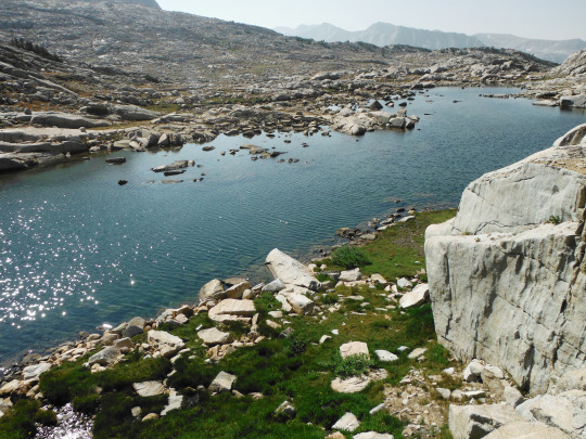
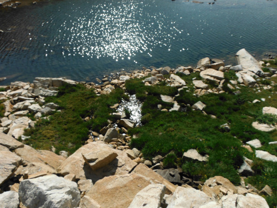
Following these small lakes, the source of Pinnacles Creek which feeds into Piute Creek, which feeds into the San Joaquin River, which flows to the San Francisco Bay. John Muir Wilderness, Sierra Nevada Mountains, California, USA. Photo by Van Miller
#pinnacles lakes basin#san joaquin river#Piute Creek#san franciso bay#san francisco#hiking#backpacking#camping#john muir wilderness#Sierra Nevada Mountains#california#©Van Miller#photography#travel#Wanderlust#geology#lakes#mountains#Wilderness#the wilderness journals
218 notes
·
View notes
Text

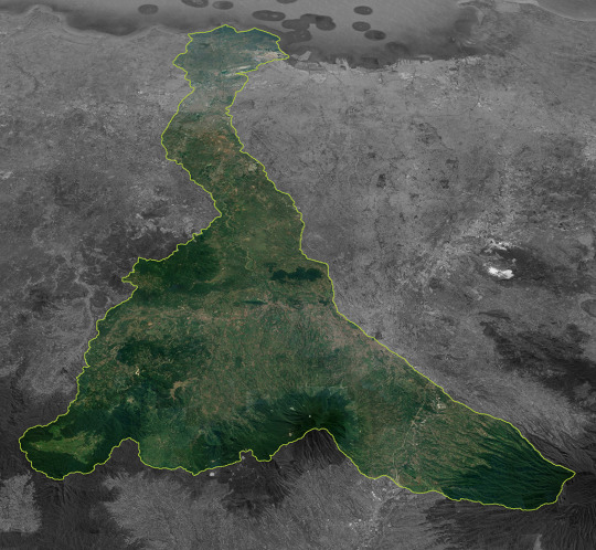
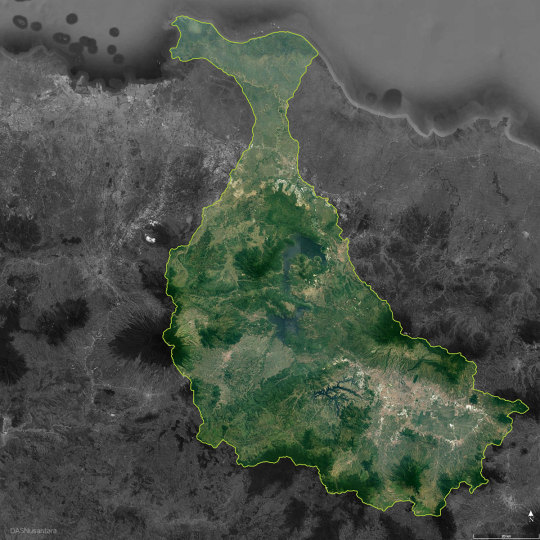
Cisadane river basin - Banten, Indonesia
View in Google Maps
11 notes
·
View notes
Photo
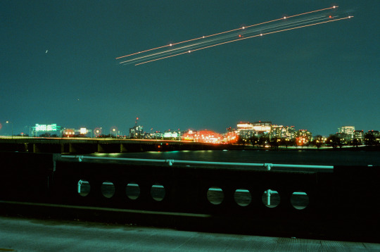
Landing over the Potomac
Shot on Cinestill 800T
#cinestill 800t#potomac river#southwest#dc#plane#film photography#tidal basin#long exposure#film#light trails#washington#february#around dc#my work#photography
172 notes
·
View notes
Text

Anaconda, Queen of the Amazon.
#vintage illustration#snakes#anaconda#the amazon#south america#jungles#south american jungle#amazon basin#amazon river#eunectes murinus#herpetology#biology#zoology
26 notes
·
View notes
Text
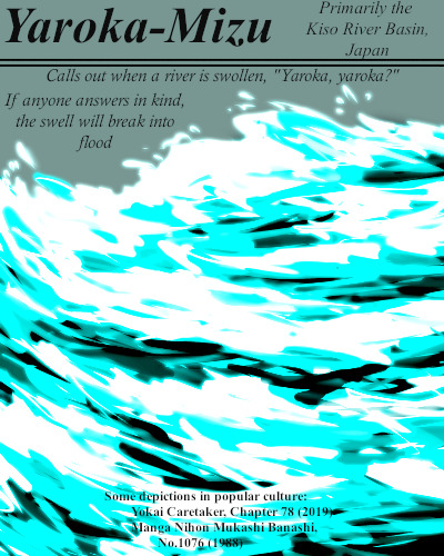
To respond in kind to the invisible Yaroka-Mizu's call is folly. Roughly translated, they ask "Do you want some?" Of course if one affirms with an answer they will give it all.
#BriefBestiary#bestiary#digital art#fantasy#folklore#legend#monster#yokai#river monster#invisible#youkai#yaroka-mizu#yaroka mizu#kiso river basin#japanese folklore#japanese legend#flood#river yokai#flood yokai
13 notes
·
View notes
Last Seen Blogs

vannyra
Untitled

askconrart
Conrart Weller

wordprax
WordPress Themes & Plugin Development Services

injuryplastersindia-blog
Untitled
