#ocean maps
Text
Hey All,
I've been away for some time, as we've been working really hard on something quite exciting:
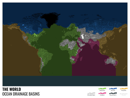
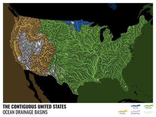
let me present to you the world's first ever global ocean drainage basin map that shows all permanent and temporary water flows on the planet.

This is quite big news, as far as I know this has never been done before. There are hundreds of hours of work in it (with the data + manual work as well) and it's quite a relief that they are all finished now.
But what is an ocean drainage basin map, I hear most of you asking? A couple of years ago I tried to find a map that shows which ocean does each of the world's rivers end up in. I was a bit surprised to see there is no map like that, so I just decided I'll make it myself - as usual :) Well, after realizing all the technical difficulties, I wasn't so surprised any more that it didn't exist. So yeah, it was quite a challenge but I am very happy with the result.
In addition to the global map I've created a set of 43 maps for different countries, states and continents, four versions for each: maps with white and black background, and a version for both with coloured oceans (aka polygons). Here's the global map with polygons:
I know from experience that maps can be great conversation starters, and I aim to make maps that are visually striking and can effectively deliver a message. With these ocean drainage basin maps the most important part was to make them easily understandable, so after you have seen one, the others all become effortless to interpret as well. Let me know how I did, I really appreciate any and all kinds of feedback.
Here are a few more from the set, I hope you too learn something new from them. I certainly did, and I am a geographer.
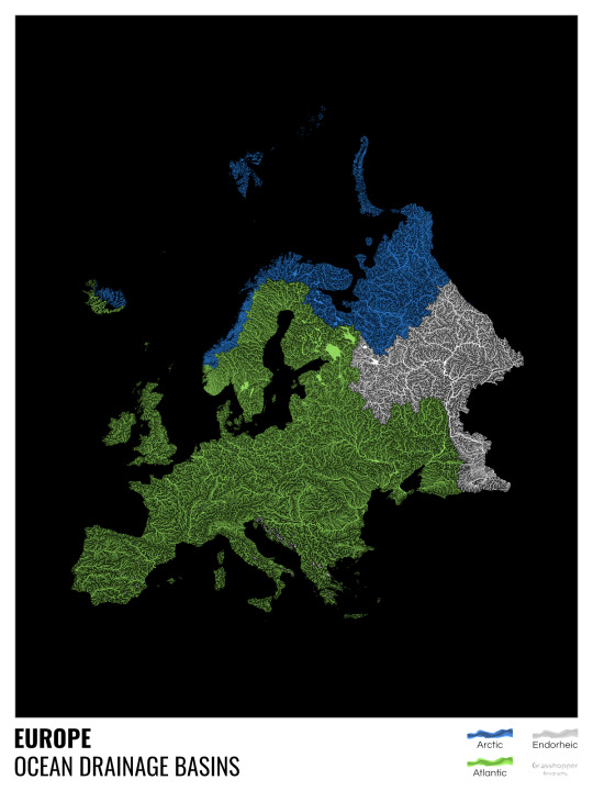
The greatest surprise with Europe is that its biggest river is all grey, as the Volga flows into the Caspian sea, therefore its basin counts as endorheic.
An endorheic basin is one which never reaches the ocean, mostly because it dries out in desert areas or ends up in lakes with no outflow. The biggest endorheic basin is the Caspian’s, but the area of the Great Basin in the US is also a good example of endorheic basins.
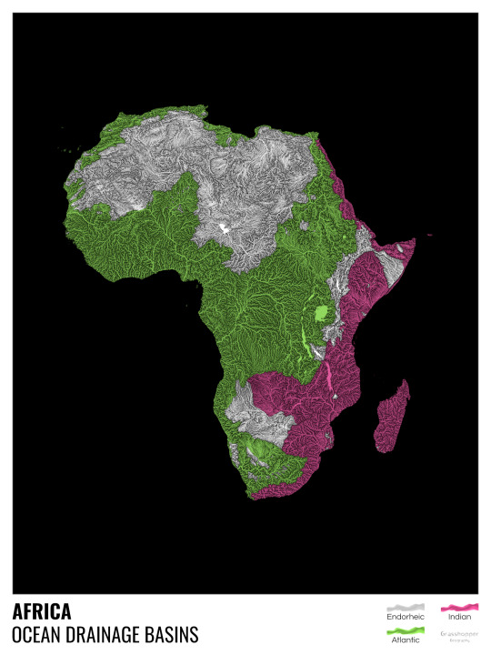
I love how the green of the Atlantic Ocean tangles together in the middle.
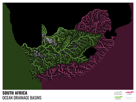
No, the dividing line is not at Cape Town, unfortunately.
I know these two colours weren’t the best choice for colourblind people and I sincerely apologize for that. I’ve been planning to make colourblind-friendly versions of my maps for ages now – still not sure when I get there, but I want you to know that it’s just moved up on my todo-list. A lot further up.
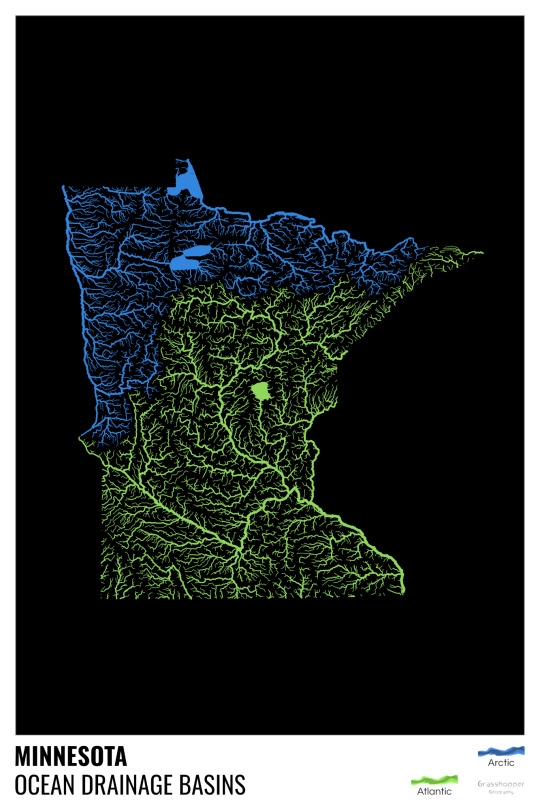
Minnesota is quite crazy with all that blue, right? Some other US states that are equally mind-blowing: North Dakota, New Mexico, Colorado, Wyoming. You can check them all out here.
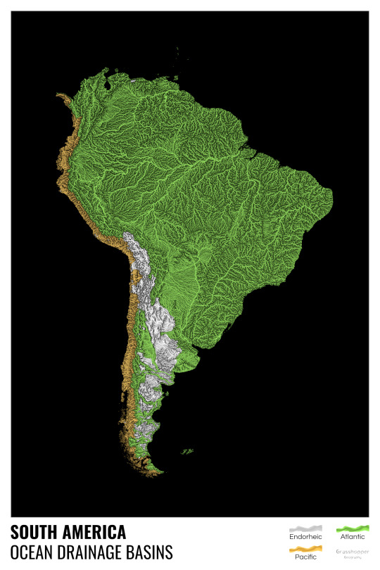
Yes, most of the Peruvian waters drain into the Atlantic Ocean. Here are the maps of Peru, if you want to take a closer look.
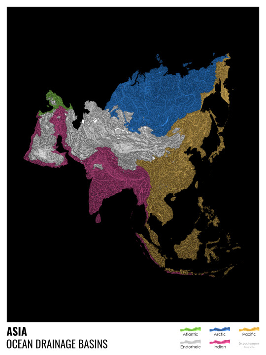
Asia is amazingly colourful with lots of endorheic basins in the middle areas: deserts, the Himalayas and the Caspian sea are to blame. Also note how the Indonesian islands of Java and Sumatra are divided.
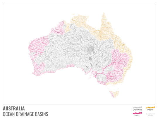
I mentioned earlier that I also made white versions of all maps. Here’s Australia with its vast deserts. If you're wondering about the weird lines in the middle: that’s the Simpson desert with its famous parallel sand dunes.
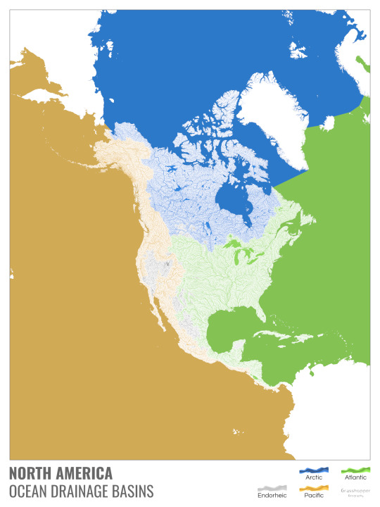
North America with white background and colourful oceans looks pretty neat, I think.

Finally, I made the drainage basin maps of the individual oceans: The Atlantic, the Arctic, the Indian and the Pacific. The Arctic is my favourite one.
I really hope you like my new maps, and that they will become as popular as my river basin maps. Those have already helped dozens of environmental NGOs to illustrate their important messages all around the world. It would be nice if these maps too could find their purpose.
#maps reimagined#geography#cartography#maps#my art#rivers of the world#ocean drainage basins#ocean maps#river maps
16K notes
·
View notes
Text
star sailor 🎇
this was drawn a little over 2 weeks ago as i was in the middle of act 2! it's kind of funny in retrospect hahaha i put the star shaped light on sif as a nod to my vague theory that sif had a star for a heart/soul but lost it. Well it wasn't quite right but there was one line of dialogue going towards that direction? a win is a win
#the story with the boat <3333#even after the whole game that kind of stuck w/ me#just a little guy out in the ocean :(#that and how sif just Knew how to fish#i love fishing. i think isat should update with a fishing mechanic.#one of the things i did Every Loop#this was just a quick scribble but#definitely want to do more star map aesthetic stuff w/ sif#abusing the same color palette?#not me... no way... /s#enough tags rambling haha#in stars and time fanart#in stars and time#isat#isat siffrin#vague spoilers#isat spoilers#just to be safe#isat act 2 spoilers#siffrin fanart#in stars and time siffrin#artilite#artilite art
617 notes
·
View notes
Photo
Source details and larger version.
Strange maps and even stranger maps are collected here.
694 notes
·
View notes
Text

Jolyne sketches :o
I like the way the green turned out in this :]
#my art#jolyne cujoh#jjba#stone ocean#i was testin out the green gradient maps#because i dont use them too often
1K notes
·
View notes
Text


GEM GEM GEM
#hermitcraft#hermitcraft season 10#geminitay#geminitay fanart#scooter.draws#my art#she’s based on those uhh#uhhh#old ocean map sea monsters#but it doesn’t REALLY translate into the design#I love her though 🫶#fanart#mcyt fanart
201 notes
·
View notes
Photo

3D Maps Reveal a Lead-Laced Ocean
About 1000 meters down in a remote part of the Atlantic Ocean sits an unusual legacy of humanity’s love affair with the automobile. It’s a huge mass of seawater infused with traces of the toxic metal lead, a pollutant once widely emitted by cars burning leaded gasoline.
163 notes
·
View notes
Photo

How big is Indonesia? Its territory as long as a distance from USA and Europe.
424 notes
·
View notes
Text

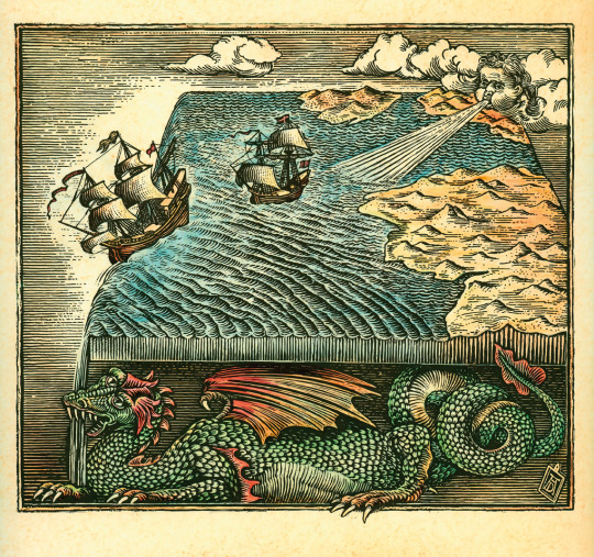
#photography#aesthetic#beautiful#lifestyle#adventure#map#kraken#monster#sea#ocean#cartography#sailing#nautical#ship#navigation
207 notes
·
View notes
Text
The Driftwood Cove Battle Map
You can now download our new 44x32 seaside battle map on our website! All you need is a team of monsters (or one big one). What comes to mind?
→ Download it here!
#ttrpg#tabletop#dungeons and dragons#dnd#dungeons & dragons#d&d#d&d5e#pathfinder#gurps#rpg#top-down#battle map#map#cartography#encounter#coastal#sea#ocean#beach#tropical#cliff#bay#cove
388 notes
·
View notes
Text
🍭 * ✧ ˚ · 🐛 * ✧ ˚ · 🌈 * ✧ ˚ · ❄ * ✧ ˚ · 💝ʕ✩..•( ᴥ )•..ʔ ⌒ *・゜゚・*:🍬🍃🍯✿ׄ ᳝ 💗𝆬⃝. ˖ ᘝ ׄ ː ׅ カラフルな虹 ۫ ՚՚ ּ ୧ ᳝🍔̲ׄ ୨。゚☆: *.🎒🧃🌈 .* :☆゚。:°ஐ*。:°ʚ🌈ɞ*。:°ஐ*。:°ஐ*。:°ʚ🌈ɞ*。:°ஐ* ◕‿◕✿。:°ஐ*。:°ʚ🌈ɞ*。:°ஐ*。:°ஐ*。:°ʚ🌈ɞ*。:°ஐ* ◕‿◕✿🍮🍓💕💖🌈🎒🌰・。゚🍭.*・♡︎·˚ ഒ*。゚・。゚🍭.*・♡︎·˚ ഒ*。゚・。゚🍭.*・♡︎·˚ ഒ*。゚
᳝🎀 ۫ ᮫ ˚✶۪ ᮫ׄ𝆬⃝🍮❝𝐫𝐚𝐢𝐧𝐛𝐨𝐰❞🥄 𝅄ׄ 🌈💖🌰
#🌈🍓🌽₊˚‧ ︵‿₊୨ ŁØνЁ ୧₊‿︵ ‧˚₊💕🌭🌈🌰🎀🌘 ⊹ ︶⏝ ⊹ ⏝︶ ⊹🐸💖🍮#ア���メ#かわいい#⊹ ⋆꒰ఎ ♡ ໒꒱ ⋆゚⊹#🎀。゚・。゚ᐠ( ᐢ ᵕ ᐢ )ᐟ。゚・。゚🎀#game soundtrack#kirby's adventure orange ocean map#kirby#mario bros the early years#kawaii#aesthetic#animecore#otakucore#webcore#weebcore#neetcore#pinkcore#kidcore#moecore#sanrio#sanriocore#my melody#cinnamoroll#pixel graphics#my edit#y2k#y2k core#nostalgiacore#fav song#90s
166 notes
·
View notes
Text
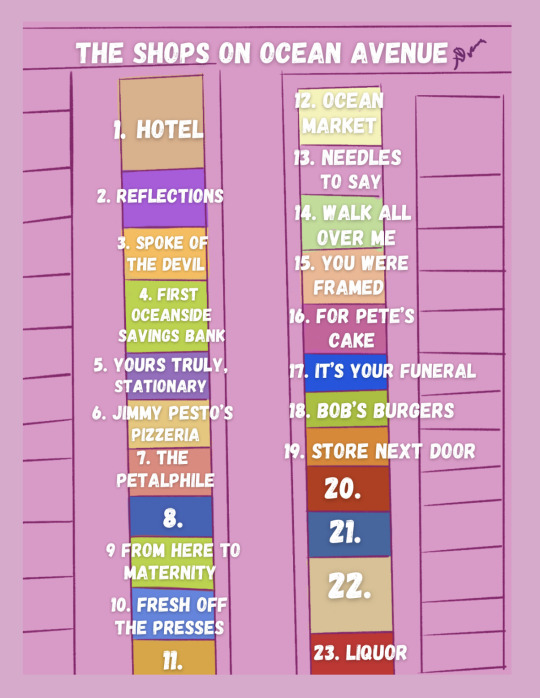
Inktober Day 5- Map
TLDR - Here’s a map of the shops on Bob’s Burgers Ocean Avenue as based on the Bob’s Burgers Movie and parts of season 13. Extensive Notes to follow.
This is the map I alluded to earlier in the week of the storefronts with visible names in the movie. The dimensions of the buildings are based on the aerial shot from the end of “The Plight Before Christmas”.
There are inconsistencies between the movie and the series (as well as within the movie itself) as far as the color and location of some of these buildings. I’ve defaulted to colors used in the series but names from the movie. Several of these shops have had different names earlier in the series so I’m working from the movie onward for consistency’s sake.
1. Hotel- Unsure if this hotel has a name.
2. Reflections
3. Spoke of the Devil (Bike Shop) - Shop is named “Spoke of the Devil” the words “bike shop” can be seen as part of a neon sign in the window.
4. First Oceanside Savings Bank
5. Yours Truly, Stationary
6. Jimmy Pesto’s Pizzeria
7. The Petalphile
8. Unknown store front - This building is usually depicted as blue with a large front window indicating that it’s some sort of storefront but I’ve been unable to find a name so far.
9. From Here To Maternity (Pregnancy Clothes) - The movie depicts this building as being brown but the series almost always shows it as green so I’ve made it green on the map.
10. Fresh Off The Presses (Cleaners) - Shop is named “Fresh Off The Presses” with “cleaners” in a neon sign in the window.
11. Unknown Store Front - This shop has a visible name in several shots from the movie but I can’t make it out.
* Some shots from the movie show an additional pink building at the end and others don’t. It does not have a awning or large front window and could therefore possibly residential or a service (such as a lawyer). This building does not appear in the aerial shot so I did not include it.
12. Ocean Market
13. Needles to Say - This shop as well as the following three also appear in season thirteen and are particularly visible in “What a (April) Fool Believes”.
14. Walk All Over Me (Flooring Showcase)
15. You Were Framed (Picture Framing)
16. For Pete’s Cake
17. It’s Your Funeral (Home and Crematorium)
18. Bob’s Burgers
19. Store Next Door - The often vacant orange store front next to Bob’s.
20. Red building- This building is very visible in several shots but isn’t shown to have a name. It has three front doors at the top of some stairs. Because of its layout it seems most likely to be residential. (As we know this neighborhood has mixed zoning, such as Mr. Huggins’ apartment building)
21. Blue Building - The positions of this building and the beige building are switched in the movie. In the series it’s fairly consistently blue so that’s what I’ve included. It seems similar in structure to the red building and could also be residential, but we don’t get many good shots of this part of the street so it’s hard to tell.
22. Beige Building - This part of the street is most often seen from the alley. It appears to have a loading dock. This where Alice parks her food truck in “As I Walk Through the Alley of the Shadow of Ramps” in season 8.
23. Liquor - This building has been depicted in different colors but has a prominent sign stating “Liquor”. I’ve seen it called “Oh La Liquor” but I’d like to see this in later season materials.
This is just what I’ve gathered as of ep 14.1. Please feel free to let me know if you have any additional information. (Or an official map) I’m absurdly invested in this.
There is also an aerial shot from the movie that shows Wagstaff in relation to Ocean Avenue (it’s also mentioned to be four blocks away) and I just wish I could take screen shots so I could study it better. I’ll make a map of this whole dang town.
#bobs burgers#inktober#inktober2023#bob's burgers#the bobs burgers movie#map#ocean avenue#procreate#my art tag#does this count as art#digital art#fanart#artists on tumblr#reference
175 notes
·
View notes
Text
I can’t believe the real villain was global warming this whole time
#one piece#one piece 1113#op spoilers#ohhhh I’m insane rn#oda is absurdly good at plot twists#you never see them coming but they always make so much sense#that u feel stupid for not figuring it out earlier#like we JUST SAW the flooded remains of old wano#and the ocean rising because of that island being wiped off the map
44 notes
·
View notes
Text

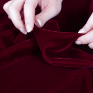
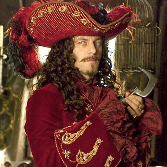


Captain Hook from Peter Pan (2003) for @claricelector1991
x/x/x|x/x|x/x/x
#stim#mine#my stimboard#pirate#peter pan#captain hook#peter pan (2003)#red#gold#brown#silver#coin#tw gun#gun#paint#map#fabric#velvet#ocean#pirate ship
75 notes
·
View notes
Photo
Source details and larger version.
Strange maps and even stranger maps are collected here.
325 notes
·
View notes
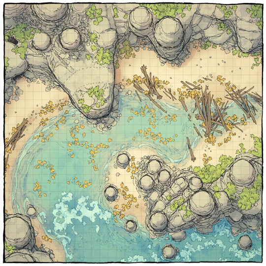
Text

Coastal Cliff Battle Map By Hassly
Check out Tabletop Gaming Resources for more art, tips, and tools for your game!
#Hassly#map#battlemap#coast#shore#ocean#sea#aquatic#tabletop rpg#rpg#tabletop gaming#pen & paper#roleplayer#roleplaying games#games#inspiration.pen & paper games#dnd#d&d#pathfinder#dungeons & dragons#dungeons and dragons#fantasy rpg
116 notes
·
View notes
Last Seen Blogs

the-stray-liger
Im a savage. penis size average

plonkeepoos
we're all doomed

just-emotionalistic
Lethanavir

girls-not-rey-blog
Android Hacks & iOS Hacks

sheenmagazine
Sheen Magazine