#Cascade Loop Scenic Highway
Text
Repulse Peak by Fisher Peak via North Cascades Highway / 擊退峯
Repulse Peak by Fisher Peak via North Cascades Highway / 擊退峯
Repulse Peak by Fisher Peak rests above Grizzly Creek. It also sits on the crest connecting to Ragged Ridge, doubling as the park boundary. North Cascades Highway offers this obscure summit’s least challenging route.
Repulse Peak in full view
See more trip photos here.
Repulse Peak at a Glance
Access: Swamp Creek pulloutRound Trip: 7.8 milesElevation Range: 3880′-7923′Gear: helmetRoute Info:…

View On WordPress
#Cascade Loop Scenic Highway#Cascades#Highway 20#Highway 530#I-5#Labor Day#mountaineering#North Cascades Highway#North Cascades National Park#North Cascades Scenic Highway#repulse peak#rock climbing
0 notes
Text

365 Things To Do In Scenic Washington State
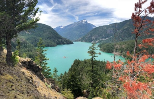
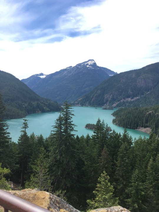
#302 - See the brilliant blue of Diablo Lake. Located along the North Cascades Scenic Highway, the intense turquoise hue of the lake's water is attributed to the surrounding glaciers that grind rocks into a fine powder that is carried into the lake through creeks. That fine powder stays suspended in the lake, giving the water its brilliant color. (Photo via Wandering Weekender)
Cascade Loop Scenic Highway
#washington#Diablo lake#north cascades#scenic highway#turquoise#lake#glaciers#rocks#creeks#rivers#water#washington state
0 notes
Text
The Cascade Loop National Scenic Highway
The Cascade Loop is one of 29 scenic byways in Washington. The 440-mile loop stretches 9 regions each with unique tourist attractions and recreational opportunities. Adventures don’t stop at the end of summer. Winter activities are just as wonderful to experience. Variety through the North Cascades from ocean to mountain makes a splendid and truly delivered experience.
Link to sneak peek video for Instagram. https://youtube.com/shorts/ICMoLYbDKoE?feature=share
0 notes
Photo

North Cascade Scenic Highway
#washington state#diablo lake#north cascades#Ross lake#Highway 20#north cascades scenic highway#cascade loop#Pacific Northwest#pnw#pnwonderland#my posts
67 notes
·
View notes
Photo

The Smell of Death but Beauty still Prevails! by 7j7s7 http://ift.tt/2irwX7G
#trees#landscape#forest#nature#smoke#fires#forest fires#Scenic Highway#Cascade Loop#Northwest Cascade
17 notes
·
View notes
Text
Status: Closed { @jamesxkingsley }
Location: Heading to Cascades Scenic Highway
The goal was fill time in the days Robbie had for his birthday. A camping trip with Ezra followed this brief roadtrip with Jamie and Robbie couldn't be happier. While he'd have loved to take the whole Cascade loop, there was only time for the North Cascade highway. A three day trip as opposed to five days he'd need for the whole loop. They wouldn't be camping instead stopping at any towns along the way. Their first check point was in Chelan, three plus hours away from Seattle. Robbie was beyond ready. "Do you want to be on picture duty while I drive?" He asked. It seemed lame but he brought a camera for this trip. They needed their phones for navigation. Which cramped his plans for pictures. The solution, buy a separate camera. “I have backup batteries and portable chargers in the glove box if your phone or the camera dies at all.”

2 notes
·
View notes
Photo

Chinook Pass Summit, WA 410 Highway, Boundary of Mt, Rainier National Park and Wenatchee National Forest and also Boundary between Pierce and Yakima Counties, Washington, 2014.
One of my favorite places along any route anywhere! WA 410 is among the most scenic roads in the state. Driving east on Highway WA 410 one crosses Chinook Pass and almost immediately is in Eastern Washington, quite unlike the other highway passes where the transition is more gradual. Near this bridge which carries the Pacific Crest Trail across the highway is a web of some of the most amazing hiking trails in the Cascades including the PCT itself, a marvelous hike either northward or southward, short loops around lakes and peaks, and connections to various trails penetrating into the park and adjacent wilderness areas. This is a nostalgic post as there is little chance of visiting the PNW, let alone hiking there, in 2021.
#highways#landscape#mountains#mountain pass#mt. rainier national park#wenatchee national forest#pierce county#yakima county#washington state
17 notes
·
View notes
Text
Hood Canal Three-Day Loop
3-5 February 2021
This was a nice contrast to last summer's three-day loop from Seattle. That one was into the Cascades (previous rides); this one was over to Hood Canal. That one was in great summertime conditions; this one was in cold, often gray mid-winter bleakness (though there were sun breaks, too). The trip consisted of three 45-mile days (less, actually, since I think the mileage the first and last day includes the ferry rides) with lots of little ups and downs and perhaps 6 or 7 miles of dirt. And another 10+ miles on fairly busy roads with little shoulder.
Wednesday, February 3rd
2nd Avenue bikeway through a COVID-quiet downtown. Bike path around Duwamish Head and along Alki Beach, then Beach Drive south to Lincoln Park and the Fauntleroy Ferry. From Southworth, it was mainly backroads over to Highway 3, then a fast ride down the hill into Belfair. Coffee and a sandwich outside of Starbucks, then a short (busy) ride to Belfair State Park. There was plenty of time to set up camp, then walk down to the water before it got dark.


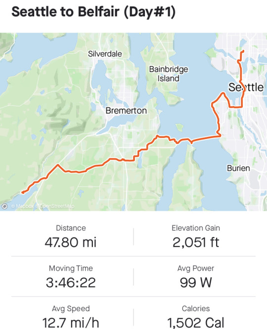
MAP: Ride with GPS
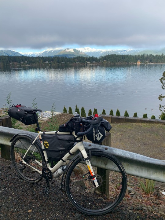
Thursday, February 4th
North Shore Road, paved and flat through Tahuya and out to Rendsland Creek, but then the pavement runs out and the dirt road winds along the forested slopes above Hood Canal, with lots of small hills that included a couple of short, very steep pitches that forced me off the bike. The road rejoins pavement before dropping down to Dewatto Bay (about as remote a corner as you can find on Puget Sound), then continues through forests, clearcuts, and occasional small farms towards Holly. I didn't see more than two or three cars in the hours between Tahuya and Holly. I grabbed snacks and a sandwich at the Seabeck General Store, then backtracked slightly to camp at Scenic Beach.


MAP: Ride with GPS
Friday, February 5th
Another night where the rain held off. My first stop was coffee in Seabeck, then 40 minutes on the relatively busy Seabeck Highway and the very hilly Anderson Hill Road, neither of which has significant shoulders. The trail along Clear Creek north of Silverdale was a pleasant change. The road from Silverdale to Poulsbo is busy, but the shoulders are very wide and the gradient on the long hill isn't too bad. Then zigzagged across to Kingston where I rode onto the ferry just before noon.
It finally started raining as I climbed through Edmonds and into Shoreline, where I connected with the Interurban Trail back into Seattle. I was home by 1:30. I took a long hot shower and washed the muck off the bike.

MAP: Ride with GPS
1 note
·
View note
Text
South Early Winters Spire Southwest Couloir + Blue Lake Peak / 南早冬尖塔
South Early Winters Spire Southwest Couloir + Blue Lake Peak / 南早冬尖塔
South Early Winters Spire southwest couloir makes the most popular early-season snow climb. Sitting above Washington Pass, the peak is also the highest point of the Liberty Bell. Its nearest taller neighbor sits over on Copper Benchmark.
One step closer to South Early Winters Spire
See more trip photos here.
South Early Winters Spire at a Glance
Access: Blue Lake TrailheadRound Trip: 4…
View On WordPress
#Cascade Loop Scenic Highway#Cascades#early winters spires#Fourth of July#Highway 20#liberty bell mountain#mountaineering#rock climbing#south early winters spire#Washington Pass
0 notes
Photo

Highway 20 closed for the season on December 11th. It is the northernmost route across the Cascade Range in Washington. This scenic byway offers travelers a variety of beautiful vistas and is part of the Cascade Loop, a 400 mile driving tour through the Cascades. ⠀⠀⠀⠀⠀⠀⠀⠀⠀ But dry your eyes because you can still access the closed portion of highway 20 during the winter season...but not by car. Hikers, skiers, snowmobilers and winter enthusiasts can park at Ross Lake trailhead, usually the closest parking lot to the closure, and enjoy all the winter fun times the Cascades have to offer. ⠀⠀⠀⠀⠀⠀⠀⠀⠀ The highway is closed due to avalanche risk. Highway 20 closure zone has 27 avalanche chutes, some more than 2000 feet above the highway. Compared to other mountain passes like Stevens and Snoqualmie, which have avalanche chutes well under 1000 feet high. ⠀⠀⠀⠀⠀⠀⠀⠀⠀ So please check forecasts as weather can change quickly in the mountains. ⠀⠀⠀⠀⠀⠀⠀⠀⠀ Catch you on the flip when the road reopens, usually sometime in May. ⠀⠀⠀⠀⠀⠀⠀⠀⠀ 📸: @thepinezcompany https://ift.tt/38VqmMd
8 notes
·
View notes
Text
Rain rain go away
Well it’s been a while! Our plans got switched around quite a bit in the last 2 weeks, so we are a little off schedule in getting a blog post out. The last time we checked in we had just finished the Abel Tasman Coastal Track on the northern coast of the South Island and were stopped in Westport for a few nights post-hike.
After leaving Westport, we embarked on the scenic drive south on Route 6 along the wild and rugged western coast of the South Island. The west coast is where the mountains meet the sea, and Route 6 skirts the fine line between the cascading forested peaks and the dark rocky beaches. We drove a few hours down the winding, rugged road, making a few stops along the way to take it all in. One of the most noteworthy places we stopped was in Punakaiki on the western edge of Paparoa National Park, where we took a short walk to view the pancake rocks and blowholes. The pancake rocks are odd, stacked rock formations that are still somewhat of a geological mystery, and the blowholes release surges of sea spray through hollowed out rock caverns. It was a beautiful walk and a nice way to stretch our legs after a few hours of driving. We made it to a free campsite at Whataroa Gorge that afternoon, where we cooked a delicious dinner, went for a quick dip in the river, and tucked in for the night. The next morning we woke up to rain and cold, and decided we would use the overcast weather to put a dent in our drive south to another free campsite in the parking lot of a cafe a few hours away. After holing up in the cafe for a while, and without much else to do in the pouring rain, we figured we might as well put in a few more hours of driving. We stopped at the roaring Fantail Falls in Mount Aspiring National Park before making our way to Wanaka, a beautiful lakeside town flanked by hills and mountains. At this point, we were both a bit cranky after being in the car for 5 or 6 hours, but we found a campsite, whipped up a quick dinner of instant noodles and hunkered down for the night.
The next day, we were pleasantly surprised to find another service hub in Wanaka that offered free hot showers, wifi, water, etc. to van/camper-dwelling travelers, so we stopped in to get all cleaned up and refreshed. Fortunately the sun had come out again, and we took advantage of the good weather by seeking out a cliff jumping spot that had been recommended to us by a friend of Chris’ who had spent a semester abroad in New Zealand. We drove down a long gravel road to a trail that lead down to a gorge on the Motatapu River. The gorge was beautiful, with clear teal water carving through rocky cliffs and we were lucky enough to have it all to ourselves. There were a few different spots to jump (I went for the shorter, less scary ones, and Chris went for the higher ones) and the water was shockingly cold, but we had an awesome time and were happy we got the recommendation. As we were drying off and preparing to leave, a few people had just arrived to the gorge and told us about another jumping spot a few miles up the road. After a few wrong turns, we made it to the trailhead and hiked to a small riverside beach. We were told to walk upriver for a few minutes to another gorge with a few different jumping spots, so we walked and swam our way to a beautiful opening in the river channel. We jumped in a few times and then floated our way back down to the beach. It was super fun and we were grateful to get a local tip :)
We spent another night in Wanaka before driving south to Queenstown, where we restocked on some groceries, stopped in for a shower at another service hub, and departed towards a campsite in the small town of Lumsden. The weather had begun to turn again, and the next day we were greeted by what would be the start of an extremely rainy week. We were getting a bit nervous - our next Great Walk, the Kepler Track in Fiordlands National Park, was coming up in a few days and the forecast was very foreboding. In the next couple of days we drove farther south, stopping in at a few towns for farmers markets and refuge from the rain. We camped along the beautiful southern coast in Pahia, and then looped up towards Te Anau where we would begin the Kepler Track. The morning we were supposed to leave for the trek, we checked the weather only to see a 100% chance of heavy rain every day for the next 4-5 days, with forecasts of flooding and landslides possible. The main draw of the Kepler Track are the spectacular views, so we decided to postpone our hike by about a week in hopes that the weather would clear. Our next Great Walk after the Kepler was supposed to be the Routeburn Track (also in Fiordland National Park), so we decided to stop in at the visitor center in Te Anau to ask about the status of the trails.
When we arrived, we were informed that there had been a major landslide on the road leading out to the Routeburn Track, as well as multiple landslides along the trail itself, and that it would likely be closed for the rest of the season. We were pretty bummed that we wouldn’t be able to do the Routeburn anymore, but felt grateful that we weren’t out on the trail when the landslides happened - one of the slides hit a hut on the trail and everyone had to be evacuated out by helicopter! The ranger at the visitor center also informed us that all of the major highways going north were flooded due to the heavy rains, as well as some of the highways leading east, so we had few options for where to go in our time before Kepler. We were able to drive to Lumsden again, avoiding multiple flooding detours along the way, and camped there for the night. The town of Lumsden was generous enough opened their community center for the night as a place for stranded freedom campers to come and escape the rain and wind. They offered warm drinks, cookies, and a space to hang out for everyone - Chris and I ended up guiding an impromptu yoga lesson to a group of German girls who were also stuck there. We were extremely grateful to the people of Lumsden for their hospitality and kindness. :)
The next few days were a little bit of a drag - one of the downfalls of van life is the lack of options in poor weather, and we found ourselves feeling a bit trapped and restless. We drove between a few different towns and spent most of our time between the van, libraries, and cafes while the rain continued to come down in sheets. One of our nights was spent in the parking lot of a rugby club in the small town of Edendale. Only an hour so after we arrived, a helicopter landed in the field adjacent to us and dropped off mattresses and blankets for evacuees in the area. Two of the neighboring towns had been evacuated due to flooding, one of which was at risk of a toxic Ammonia gas leak as a result of waste left in an old paper mill along the river that wasn’t supposed to get wet. The south island is used to a lot of precipitation, but apparently this rain event was a one in every 100 years type of occurrence.
Finally the rain began to clear and we drove back along the southern coast to make our way towards Fiordland National Park for the second time. We stopped in the beautiful Colac Bay to camp for a night and explored the rocky beach, relieved to be outside after so many days stuck in the van. While we were walking, we spotted a sign about harvesting mussels at low tide, and figured we should scout out the area in case we came across any. Once low tide came around, we walked down to the rocks and Chris found hundreds of New Zealand’s green-lipped mussels clinging to a boulder just below the tideline. He harvested 44 of them and we cooked them up for a dinner of raviolis, mussels, and broccoli in a white cheese sauce. It was delicious and fun to know that we had harvested part of the meal ourselves. :)
After Colac Bay, we drove to the southern region of Fiordland National Park to the deepest lake in New Zealand, Lake Hauroko. We hiked an hour up a steep, rugged trail to a lookout point over the lake, stopped for a break to take it all in, and made our way back down to go for a swim. After our swim we were attacked by swarms of sandflies, New Zealand’s resident biting fly, and made a quick escape into the van before driving to our campsite by the Clifden Suspension Bridge. The following day we took a walk among the towering Totara trees, an enormous tree species endemic to New Zealand, and then prepped for the Kepler Track which we would be starting the next day. The weather forecast predicted the next three days to be in the 60s, clear and sunny, and we were thanking ourselves for deciding to change our plans.
On our first day, the Kepler Track took us through lush, fern-laiden forests and over rushing streams and rivers. The trail was relatively flat with minor undulations, but it was a long day for both of us at about 13.7 miles. After 6 hours of hiking we arrived at the Iris Burn campsite, feeling sore but accomplished, and excited for a rest. We had a typical backpacking dinner of instant rice, quinoa, and lentils, with a dessert of peppermint tea and gummy fruit jubes. We ended up talking with a lot of the other campers, and were shocked by how many other Americans were on the trail at the same time as us. We’ve hardly met any other Americans in our travels so far, and there were about 8 of us at this one campsite - two were from Maine and one had graduated from UMass in 2019 as well! It was a nice and unexpected taste of home, and it felt good to recount pieces of home with them. When we got into our tent for the night, we noticed that someone had set their tent up about three feet away from ours, but we shrugged it off at the time assuming they were just trying to find a flat spot. About an hour or two later, loud, jagged snores began coming from the adjacent tent. We tried to ignore it and fall asleep to no avail, and ended up carrying our tent through the woods in the middle of night to escape the noise.
We woke up the next morning a bit tired from the snoring fiasco, but ready for the long day ahead. The second day was going to be the hardest day by far - nearly 15 miles up and over Mount Luxmore standing at just over 4800 feet. We spent the first 3 hours on the trail winding up a series of unforgiving switchbacks before arriving at the Hanging Valley emergency shelter. We were already feeling exhausted, but the views were absolutely spectacular - soaring, snow-peaked mountains towered over Lake Te Anau and glacier carved valleys surrounded us on all sides. We stopped for some trail mix which we had to keep away from the local Keas - the world’s only alpine parrot which are notoriously clever at stealing from people. After a quick rest carried on across the ridgeline and up the remainder of Mount Luxmore. Three hours later we arrived at Luxmore Hut, a hut on the far side of Mount Luxmore overlooking Lake Te Anau. We still had about 5 miles to go to our campsite, but we took a quick snack break and rested our feet while looking out at the stunning view. Fortunately, the last 5 miles were downhill and our bodies were grateful for a break from the relentless uphill climb. After a long, 8.5 hour day of hiking, we arrived at Brod Bay Campsite, feeling weary and relieved to be done. We set up camp, went for a swim in the lake, and made a fire on the beach while we cooked dinner. It was a lovely way to end the day and we relaxed by the flames before settling into our tent for the night. We had seen mice around the campsite so we brought our food bags into the tent with us in hopes that they wouldn’t eat any. At around 4 am, I awoke to the sound of rustling in our tent, and looked towards our food bags to see a mouse nibbling at our trail mix. Startled, I yelped and woke Chris up, and continued to panic a bit as the mouse ran and jumped around our tent. Eventually after a few failed attempts to catch the mouse, we emptied the tent out and shook it out. Now wide awake, and with little hope of falling back asleep, we decided to hike out at 5 in the morning. The majority of the 9.5 miles out to the parking lot was in the dark, and we were definitely the only ones on the trail. While we were a little bit delirious, it was cool to hike at night, and we think we heard the bird calls of the endangered, nocturnal Kiwis!
We were off the trail by 9 am, and drove to Queenstown for a much needed shower and celebratory pizza. Since then, we’ve spent 2 nights camped by Lake Dunstan outside Cromwell, a town about 45 minutes north of Queenstown. In the next few days we will be heading east to Alexandra to meet up with Chris’ friend from Northeastern, Camille, who is also living in New Zealand right now. After that, Chris’ sister, Madeline, is coming to visit for about a week, and then we will try to sell the van in the Christchurch area! It’s crazy that our time in New Zealand is starting to come to an end, we’ll be leaving for Australia in just under a month from now! We will be sad to part with this incredible country, and are cherishing every day we have left here. We still have a few more exciting adventures to come before we head out, and are looking forward to having Madeline around to share them with. :)
Loving and missing you all from afar,
Bryn and Christopher
1 note
·
View note
Text
History and Recreation on the Mountain Loop Highway:
Assignment one rewrite
Snohomish County, February 6, 2023 – Located in the foothills of the North Cascades the Mountain Loop Scenic byway is a 52-mile Washington state highway in Snohomish County.
It’s a popular weekend getaway for people from across the state. Spread out next to the Sauk or Stillaguamish Rivers and breath in fresh fragrances of pine sap and maple tree bark.
Checking in with visitor information receptionist Erika Morris at the Darrington information center, the Mountain Loop Highway is a great highway/byway to begin venturing outdoors. Its history rests in lumber harvesting, old mining camps and railroads.
“The Mountain Loop Highway is just that; a Highway” she said. Most outdoor hiking, biking, camping trails are owned and maintained by the National Forestry Service. We maintain the nature area and public trails for recreation, hiking and camping. The actual name comes from the state-owned highway.
The Mountain Loop starts in Granite Falls, connects to Arlington and Darrington and wraps around back to Granite Falls. Stationed at the Verlot ranger station just outside Granite Falls is ranger Jonathan Sutherland. He looks after trails and campgrounds from Verlot to about Bedal Campground halfway between Granite Falls and Darrington.
He talked about his prior work in the peace core. “After Covid started it was hard for Peace Corps to do work. So, I came home to Snohomish and was out of work”. He applied to the National forestry service and became a park ranger in the south most part of the Mountain Loop Highway. Part of the mount Baker-Snoqualmie National Forest. “It’s work with peace of mind”.
When gold was discovered in the Cascade mountains, it came with the lofty dream of mineral wealth. The elusive rich vein of gold was never discovered. A silver deposit was found just below Boston Glacier near the headquarters of Thunder Creek in 1892. But the cost of getting the ore out was too expensive. By 1913 most mining companies had folded. “Mining didn’t resume until WWII increased the demand for metal and then again during the 1940s and 50s for the last time. Short working seasons, unpredictable weather conditions, difficult transportation and lack of working capital hampered large scale development” (National Park Service, 2020). The mining didn’t last long but the rails were in place to carry out the real treasure of the PNW – timber. Roads were built to replace rails and trucks replace the trains.
Granite Falls is known as the gateway to the Mountain Loop. Growth is strong as more people flock to rural areas in search of homes. A big part of Snohomish County history is founded in the search for natural resources and timber harvesting. Many trails along the Mountain Loop are linked to the development of nearby towns like Arlington and Darrington. A day off the Mountain Loop provides insight to the development of the area. It has a host of outdoor activities in environment education and a beautiful landscape.
References
Purdue Online Writing Lab. (n.d.). General Writing FAQs. Purdue Online Writing Lab.https://owl.purdue.edu/owl/general_writing/general_writing_faqs.html
National Park Service. (2020, January 10). Miners. https://www.nps.gov/noca/learn/historyculture/miners.htm
0 notes
Text
Washington Pass
North Cascades Photography – Washington Pass
Washington Pass is one of the most scenic spots along the entire Cascade Loop Scenic Highway.
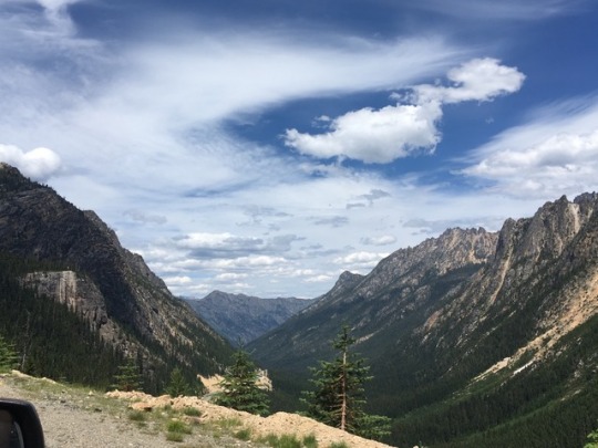
Washington Pass is the highest point along the North Cascades Highway, at an elevation of 5477 ft./1669 m. Liberty Bell towers over the thin ribbon of pavement. Heading east, the highway plunges down, to Mazama and Winthrop. The upper slopes are filed with Larch, which turn bright orange in October. its a very scenic place!
There is a trail nearby, the Blue Lake Trail.
There is so much snow each winter and the avalanche shoots so steep here that the highway closes for winter, usually in November, and opens again in April or May.
Today, April 18th, 2019 the North Cascades Highway opened for the season, one of the earliest openings I recall. There is still a bit of snow there, along the road, and the trailheads are still snowed in, they wont be open until May or June, earliest. But the road is open!
The Washington Pass Overlook, is one of those places I most always stop when I drive along the North Cascades Highway.
Washington Pass Overlook
Most overlooks are a one time deal, once you’ve seen it, no need to go back!
Not the case here.
The Washington Pass Overlook is in the Okanagon National Forest, and maintained out of the office in Winthrop. The Overlook is well marked, and the parking area is about 1/4 mile off the highway. There is ample parking, several rest rooms and some lights. There is a 200 yard paved path to the overlook, and lots of railings preventing a plunge.
NOTE: Even though the North Cascades Highway is opened, the Washington Pass Overlook may not open until May or June. The 1/4 mile road from the Highway to the Overlook parking is gated at the highway. You can park at the highway (there are usually many spots near the gate) and you can walk to the Overlook.
Here are a few pics from the Overlook.
#gallery-0-13 { margin: auto; } #gallery-0-13 .gallery-item { float: left; margin-top: 10px; text-align: center; width: 50%; } #gallery-0-13 img { border: 2px solid #cfcfcf; } #gallery-0-13 .gallery-caption { margin-left: 0; } /* see gallery_shortcode() in wp-includes/media.php */
Liberty Bell
Liberty Bell from the Washington Pass Overlook
The best time to get a shot of Liberty Bell is sunrise. The early light illuminates the sheer rock faces wonderfully… Its a long drive, from Sedro-Woolley to Washington Pass is a 2 hour drive! But worth it!
Washington Pass Overlook is also a fantastic spot for Night Sky Imaging. Its deep in the mountains, as there is low light pollution, the Lookout faces south, and you have Liberty Bell as a foreground, but also the hairpin turn of the North Cascades Highway below…
Here are a few images from my many night time visits! This is one of the locations for the Drive-In Night Sky North Cascades Photo Tours.
#gallery-0-14 { margin: auto; } #gallery-0-14 .gallery-item { float: left; margin-top: 10px; text-align: center; width: 50%; } #gallery-0-14 img { border: 2px solid #cfcfcf; } #gallery-0-14 .gallery-caption { margin-left: 0; } /* see gallery_shortcode() in wp-includes/media.php */
Liberty Bell and the North Cascades Highway
Liberty Bell and the Milky Way
Here are a few more images of Liberty Bell from Washington Pass.
#gallery-0-15 { margin: auto; } #gallery-0-15 .gallery-item { float: left; margin-top: 10px; text-align: center; width: 50%; } #gallery-0-15 img { border: 2px solid #cfcfcf; } #gallery-0-15 .gallery-caption { margin-left: 0; } /* see gallery_shortcode() in wp-includes/media.php */
Liberty Bell and Washington Pass
Liberty Bell and Washington Pass
Liberty Bell and Washington Pass
Liberty Bell and Washington Pass
Liberty Bell and Washington Pass
Liberty Bell and Washington Pass
Liberty Bell and Washington Pass
Liberty Bell and Washington Pass
North Cascades Photography – Washington Pass North Cascades Photography - Washington Pass Washington Pass is one of the most scenic spots along the entire…
#liberty bell#North Cascades#north cascades highway#North Cascades Photography#Washington Pass#Washington Pass Overlook
19 notes
·
View notes
Photo

The Smell of Death but Beauty still Prevails! by 7j7s7
12 notes
·
View notes
Photo
Best Things to do in Olympic National Park
Best Things to do in Olympic National Park: With its incredible range of precipitation and elevation, diversity is the hallmark of Olympic National Park. Encompassing nearly a million acres, the park protects a vast wilderness, thousands of years of human history, and several distinctly different ecosystems. Located on Washington's Olympic Peninsula, the park has four regions, including 70 miles of wild Pacific coastline, alpine areas, old-growth temperate rain forests and the forests of the drier east side. My name is Rob Decker and I'm a photographer and graphic artist with a single great passion for America's national parks! I've been to 50 of our 61 national parks — and Olympic National Park has so many different areas, there are tons of things to see and do! You can hike in the mountains, kayak or canoe in a lake or river, play in the tide pools, relax in the hot springs...and so much more! I've explored many areas of Olympic National Park — so I'm ready to help! If this is your first time to the park, or your returning after many years, here are some of the best things to do in Olympic National Park! Exploring the Pacific Coastline The coastal portion of the park is a rugged, sandy beach along with a strip of adjacent forest. It is 60 miles long but just a few miles wide. While some beaches are primarily sand, others are covered with heavy rock and very large boulders. The most popular piece of the coastal strip is the 9-mile Ozette Loop. The Park Service runs a registration and reservation program to control usage levels of this area. From the trailhead at Ozette Lake, a 3-mile leg of the trail is a boardwalk-enhanced path through near primal coastal cedar swamp. Once you arrive at the ocean, you can continue out on the headland trails for spectacular views and sunsets. Some of the best places to enjoy the Olympic coast include: Rialto Beach Second Beach Third Beach James Pond Kalaloch Beach 4 Ruby Beach Tidepool Activities The most popular tidepools areas are at Kalaloch's Beach 4 and Mora's Hole in the Wall. Rangers offer programs at both locations. Second Beach, Third Beach, Ruby Beach and many other coastal wilderness locations are also excellent places to view intertidal life in the park. Explore Olympic's Rivers by Kayak and Canoe There are many kayak and canoe options in Olympic National Park's rivers and lakes. Here's a quick rundown of some of the most popular spots to see the park from the water. Paddle The Rivers of Olympic National Park Elwha River (Class II-IV) This river can be paddled most of the year, but the best season is in the spring or early summer. The most common put-in sites are in the lower portions of Glines Canyon and Altair Campground. Hoh River (Class II-III) This river offers scenic views of old-growth rainforest, but is frequented with log jams. Always scout ahead before paddling to avoid hazards. The most popular put-in locations are at the Hoh Campground and near the park entrance station on the Hoh River Road. Queets River (Class II-III) Queets River is a great place to experience secluded rain forests during higher water levels. In late summer, the river is often blocked by large debris and water that is too low for paddling. Log jam hazards may exist throughout the year. Popular put-in sites are the Queets Campground above Sam's Rapid and the Hartzell Boat Launch. Quinault River (Class II-V) For expert kayakers willing to hike into the backcountry, the Quinault River offers challenging water. From the Graves Creek trailhead, hike 2.5 miles to Pony Bridge. This 3 mile route is through a gorge and has a mandatory portage at Dolly Falls. For calmer waters, a popular launch site is near-end of the North Shore Road at the bridge. Sol Duc River (Class III-V) For experienced kayakers, a 1.2 mile hike up the North Fork Trail in the Sol Duc Valley to the launch site offers fun water above Salmon Cascades. For experts interested in rapids, put-in at Salmon Cascades Overlook. Enjoy The Lakes of Olympic National Park Lake Crescent Big, deep, and blue, Lake Crescent offers a scenic paddling experience, particularly in the early morning when winds are most likely to be calm. Winds often come up in the afternoon and can quickly create waves of a foot or more. Boat launches include Storm King Ranger Station and Fairholme. Kayaks and canoes can be rented at concession operated Log Cabin Resort and Lake Crescent Lodge. Lake Ozette Near the coast and filled with summer water lilies, Lake Ozette offers a secluded paddle journey. Two boat launches exist at the Ozette Ranger Station and Ozette Campground. Kayak and Canoes can also access a few backcountry campsites. Sudden weather changes are common in the Ozette area -- always check the forecast and plan for the possibility of sudden, strong winds and waves. Lake Quinault In a rainforest valley, Lake Quinault boasts mountain views and old-growth forests. Afternoon winds are common here, so always be prepared. Two boat launches are found on the U.S. Forest Service operated Falls Creek and Willaby Campgrounds. Boat rentals are available at the concession operated Lake Quinault Lodge. Fishing in Olympic National Park Olympic National Park protects over 70 miles of Pacific Coast, 600 lakes, and 4,000 miles of rivers and streams that support some of the most extensive runs of wild salmon, trout, and char remaining in the Pacific Northwest. Only catch and release fishing is allowed, which improves native fish populations by allowing more fish to remain and reproduce in the ecosystem. This practice provides an opportunity for increasing numbers of anglers to enjoy fishing and to successfully catch fish. Releasing native fish caught while in a national park will help to ensure that enjoyment of this recreation opportunity will last for generations to come. Fishing gear is perhaps the most important factor affecting whether a fish will survive being caught and released. Use artificial lures or flies. Use of bait is prohibited in all park waters. Use rod, reel, and line of sufficient strength to quickly land the fish Use properly sized single circle or barbless hooks. Visit The Hoh Rainforest Throughout the winter season, rain falls frequently in the Hoh Rain Forest, contributing to the yearly total of 140 to 170 inches (or 12 to 14 feet!) of precipitation each year. The result is a lush, green canopy of both coniferous and deciduous species. Mosses and ferns that blanket the surfaces add another dimension to the enchantment of the rainforest. The Hoh Rain Forest is located in the stretch of the Pacific Northwest rainforest which once spanned the Pacific coast from southeastern Alaska to the central coast of California. The Hoh is one of the finest remaining examples of temperate rainforest in the United States and is one of the park's most popular destinations. The Hoh lies on the west side of Olympic National Park, about a two-hour drive from Port Angeles and under an hour from Forks. The Hoh Rain Forest is accessed by the Upper Hoh Road, off of Highway 101. See Olympic National Park on Foot Day hikes of varying length and difficulty are found throughout the park. Some are universally accessible while others are more challenging. Because of the diverse nature of the park, and depending on how much time you're able to spend in the park, you'll want to choose one or more areas to explore. Before You Go... Even on short hikes, be prepared for changeable weather. Carry food, water, raingear and extra layers of clothing. Do not drink water directly from streams. Boil water or use a water filter or other treatment that kills or filters giardia and cryptosporidium. Iodine tablets do not kill cryptosporidium. Stay on trails to avoid injury to yourself and the park's vegetation. Pack out all trash, including food waste. Wildlife Viewing Birds Many bird species share Olympic's skies. Bald eagles, northern pygmy owls, black oystercatchers and sooty grouse are among the 300 species of birds found in the diverse habitats of the park. Deer Black-tailed deer can be encountered in nearly all areas of the park. Deer often roam in the mountainous and forested locations within the park and tend to be more active during the morning and evening. Olympic Marmots Spot these charismatic animals at Olympic's higher elevations. Trails near Hurricane Ridge and alpine trails make prime destinations for marmot sightings during the summer. Roosevelt Elk Most elk sightings occur in Olympic's lower valleys and rainforests. Elk encounters occur throughout the day, but are most common during dusk or dawn. Salmon Olympic's rivers are home to all five species of Pacific salmon, as well as anadromous steelhead and bull trout. Although there are salmon migrations throughout the year, fall is the best time to view the salmon's dramatic upstream journey. Most rivers in the park host a fall salmon run, but the Salmon Cascades Overlook in the Sol Duc Valley provides one of the best views from late September to Early October. Whales The Olympic coast offers many opportunities to view whales during their migration seasons of April - May and October - November. Prime whale watching sights include Kalaloch, Rialto, and Shi Shi Beaches. Mountain Goats Although not native, mountain goats can been seen high elevation areas of the park and may be encountered along alpine hiking trails. They occasionally roam near Hurricane Ridge Visitor Center. Black Bears Black Bears are seldom sighted in areas with high human presence, such as roads and Visitor Centers. Most sightings, while rare, occur along backcountry trails. Exploring Olympic National Park in Winter At an elevation of 5,242 feet, Hurricane Ridge is Olympic's alpine destination in winter. Typically snow-covered, Hurricane Ridge provides opportunities for snowshoeing, cross-country and downhill skiing, snowboarding, tubing and more. Hurricane Ridge's winter season is generally mid-December through the end of March. Click here to see the Olympic National Park poster Rob Decker is a photographer and graphic artist with a single passion for our national parks! Rob is on a journey to explore and photograph each of our national parks and to create WPA-style posters to celebrate the amazing landscapes, vibrant culture and rich history that embody America's Best Idea! Click here to learn more about Rob and the National Park Poster Project https://national-park-posters.com/blogs/national-park-posters/best-things-olympic-national-park?utm_source=rss&utm_medium=Sendible&utm_campaign=RSS
0 notes
Photo

Just the Pacific Northwest, no biggie. ° The 400 mile Cascade Loop is a must for anyone. It was my personal introduction to Washington when I moved this past year. ° 📸 May 2018 📍 Cascade Loop Scenic Highway ° ° ° #CascadiaExplored #Cascades #cascadeLoop #PNW #PNWonderland #PacificNorthwest #PNWdiscovered #WashingtonState #LiveWashington #NikonD3400 #rei1440project #nikon #nikonusa #wanderlust #WildernessCulture #HikingCulture #UpperLeft #USA #optputside #instadaily #MoodyGram #InstaMood (at Cascade Loop Scenic Highway)
#instamood#pacificnorthwest#hikingculture#nikonusa#instadaily#washingtonstate#pnw#nikon#upperleft#cascadeloop#nikond3400#cascadiaexplored#cascades#wildernessculture#livewashington#pnwonderland#moodygram#wanderlust#pnwdiscovered#rei1440project#usa#optputside
4 notes
·
View notes
Last Seen Blogs

blackwolf-hybrid
A Smol Gremlin

4cyphergy
4cyphergy

3to5secondrush
SKATE OR DiE

conatyfoodandcateringsupplies
Untitled

jn222ek-blog
Johan Nöjd Workbook