#openmap
Text
[S] CASCADE: REANIMATED APPLICATIONS ARE NOW OPEN! 📢
📢[S] CASCADE: REANIMATED APPLICATIONS ARE NOW OPEN!
Join us for a rather ambitious project!
APPLY HERE
Art by Gilly!
805 notes
·
View notes
Text
check out my Cookie Run scripted map lol
youtube
#cookie run#crk#crob#cookie run ovenbreak#cookie run kingdom#cookie run MAP#multianimatorproject#scriptedmap#openmap#animatedmap#pmvmap#licorice cookie#vampire cookie#cookierunanimatic#espresso cookie#dark enchantress cookie#choco werehound brute#batcat#dark cacao cookie#pomegranate cookie#affogato cookie#twizzly gummy cookie#parfait cookie#clover cookie#strawberry crepe cookie#Youtube
22 notes
·
View notes
Text
هل كنت تعلم؟
هل كنت تعلم؟تقوم OpenStreetMap Uganda بتطوير تطبيق للمساعدة في جعل النقل المائي أكثر أمانًا للصيادين والمسافرين في البحيرات الأوغندية! استخدام #OpenMapping لحل التحديات المحلية https://twitter.com/osmuganda/status/1676169136148213761
View On WordPress
0 notes
Video
youtube
It’s alright // Map // Read description to join // #openmap
1 note
·
View note
Video
Open MAP for bad girl online! Me and pumpkin have been wanting to do this map
#openmap#open map#multi animator project#animation#animation map#oc map#original character#fanmade#pmv#amv#fandom oc#map parts#digital drawing#cover song#bad girl online
1 note
·
View note

Text
What Is Sharptracking?
Sharptracking is an online tracking system, using it you can monitor thousands of vehicles and display their locations and a lot of information on the map in your web browser or Mobile Application, and start managing them.
SharpTracking Features
Real-Time Tracking : Track the location of your objects (vehicle, person, bike, etc.) online in real-time.View Additional information about the exact location, speed, petrol Consumption travel history, etc.Choose from several maps: Google, Wiki Mapia, OpenMap, Yandex, etc.Even if your car always operates in remote areas where there is no mobile network coverage, تتبع المركبات stc our system supports tracking devices with data transmission via satellite.
Notifications & Alerts : Get instant notifications and alerts about your vehicles’ Via Mobile APP, POP-UP Messages to the website, Email, or SMS.Know if your driver is violating your rules, like over speeding.Know when the vehicles enter or exit geofences assigned to it.Get notifications about your vehicle’s scheduled maintenance.Get notifications about your vehicle’s documents expiration date.
Geofencing : Geofence feature allows to set up geographic boundaries around areas that have specific interest for you.Receive automated alerts whenever your vehicles enter or leave marked boundaries.You can decide to receive notification about all or part of the vehicles only, also to get the notification 24/7 or during a specific period of time only.
POI & Tools : With the Points of Interest (POI) tool, you can add markers at the locations to easily recognize it, such as worksites, warehouses, Accommodations, customer’s locations, etc.You can name the place and add a description to it.You have also tools for calculating distances between places on the map.
Logistics Management : Plan & manage your logistics & delivery operation easily.Define pickups & delivery tasks including sources & destinations.The system will help you to select the suitable vehicles to the tasks.Assign the tasks and send them to the driver’s mobile Application with full details.Monitor all task status without need contacting drivers.Get proof of delivery & customer’s signature to the mobile screen directly.Archive all the records and attached documents.
History and Reports : Reports include various information by date and GPS tracker name including driving hours, stopovers, distance traveled, fuel consumptionand cost, and much more.Detailed or grouped reports also available.Download and review report in different formats, XLS, PDF, CSV, and TXT.You can set up our platform to automatically send your daily or weekly reports to your email address.Our system can also copy your colleges.
Data Analytics : The Data Analytics module to display various graphics and pie charts about the parameter changes are shown in real-time.you will receive information about a change in the combined amount of mileage “for example” throughout the company for weekly, monthly, or yearly intervals.Analytical data is available for either the vehicle or the driver. the system will collect data about the desired object.
API interface : Simple but powerful tool, the API ”Application Programming Interface” makes it easy for developers to integrate the SharpTracking platform with any other systems “like ERP”, to retrieve data and get full ability to manage your fleet effectively.
Integration with WASL : It is mandatory by government rules for each truck to be equipped with a GPS tracker, weight sensor, in case it carries fresh chilled or frozen foods, its mandatory to add temperature & humidity sensors also, then send all this data to WASL platform, This is what our system does: Fully integrated with the WASL platform.It Collects data from GPS trackers & sensors and sends it to the WASL platform.It helps in generating detailed reports regarding the sensor’s activities.
1 note
·
View note
Text
-Open- Christmas MAP
So I have had this open for a while now and need more people to join for it to be anywhere near complete in time.
Link to video along with rules-
https://www.youtube.com/watch?v=_eieWVPJwJE
#openmap#map#christmasmap#Christmasproject#partsavalible#multi animator project#please join#im desperate
0 notes
Photo

เปิดแม๊พ #openmap #คนไม่มีเมียทำไรก็ได้ #หมาเมียง (ที่ Drakon wings)
0 notes
Text
Threat Detector for the Woodland Trust: QGIS tutorial
As part of my Threat Detector volunteering for The Woodland Trust, I am starting a series of tutorials to create maps of the assigned threat detecting area to make filtering planning applications easier.
To access the index with links to the full tutorial click here

The final result will be something like this when look at a smaller scale (with possible problematic postcodes highlighted and queryable):
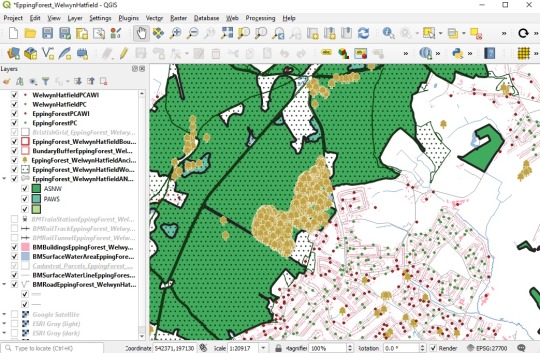
We will first need some resources (datasets) that are open and free to use, and are available online:
Great Britain boundary maps (choose one of the options to download the data. I downloaded a GeoPakage and I will have a file called bdline_gpkg_gb.zip)
Great Britain Postal code location (you can choose between CSV and GeoPakage. As CSV will need post-processing) I downloaded the later for a codepo_gpkg_gb.zip file)
Ancient Woodland Inventory (England) (go to Available Downloadable Datasets and from the map you will be able to select the full dataset in several formats or a selection of the map; I downloaded the NE_AncientWoodlandEngland_GML_Full.zip). For Scotland and Wales see more info here.
Wood Pasture and Parkland (England) go to Available Downloadable Datasets and from the map you will be able to select the full dataset in several formats or a selection of the map; I downloaded the NE_WoodPastureAndParklandEngland_GML_Full.zip). For Scotland and Wales see more info here.
Ancient Tree Inventory dataset is a bit more complicated. There is an online map, but if you want the dataset, you will need to ask for it (by sending this form) to Woodland Trust on [email protected].
Great Britain INPIRE Index Polygons spatial data (choose by local authority and then download a *localauthorityname*.glm file)
Great Britain OpenMap Local (choose one of the options to download the data. I downloaded a GeoPakage for all of GB and I will have a file called opmplc_gpkg_gb.zip). I won’t use every layer from this dataset, as it will be for giving the map some context).
0 notes
Photo
MAPS ME #1 travel maps MAPS.ME is a travel App that provides... #blogema #getdirections #gpsapp #hotelbooking #hotelbookingsites #hoteldeals #mapsanddirections #mapsapp #mapsnavigation #navigationsystem #offlinemaps #openmaps #openstreetmap #osmmanager #tipsandtricks #tour #travel #travelapp #travelblogger #travelguide #travelplanner #traveltips #vacationplanning
0 notes
Photo

MAPS ME #1 travel maps MAPS.ME is a travel App that provides... #cyrrion #getdirections #gpsapp #hotelbooking #hotelbookingsites #hoteldeals #mapsanddirections #mapsapp #mapsnavigation #navigationsystem #offlinemaps #openmaps #openstreetmap #osmmanager #tipsandtricks #travel #travelapp #travelblogger #travelguide #travelplanner #traveltips #vacationplanning https://cyrrion.com/maps-me-1-travel-maps/?feed_id=3369&_unique_id=5f24f09eb3cf5
0 notes
Text
The Best Apps for Bicycle Directions, 2020 #OpenMap
0 notes
Text
Here attacks Google Maps with new freemium website plan
When visiting the website for a local restaurant or other small business, you'll likely Google Maps embedded to show the location. Developers of such sites were recently thrown for a loop, however, when Google announced new, more expensive pricing and demanded a credit card and Google Cloud account for all API access to Maps. To profit from this discord, Here has unveiled a new "freemium" plan that offers way more free "transactions" (page loads) than Google Maps, with no need to provide a credit card.
Here, formerly part of Nokia but now a separate company owned by a consortium of German automakers, offers 250,000 free transactions per month, compared to just 28,000 free page loads for Google Maps. Prior to the new freemium tier, it would have cost developers around $120 per month for that number of page loads. On top of that, developers can build public, private, free or paid apps using the API, rather than just public apps as before. And Here emphasized, clearly in response to Google Maps, that no credit card is required for the new tier.
Developers already have a lot of free options, including MapBox, TomTom, Bing Maps, OpenMaps and others. However, Here is more complete than other offerings, with a broad range of services for consumers, businesses and fleets. It's perhaps best known by consumers for its free Here WeGo navigation app, which is a good alternative to Google Maps if you don't want to use your mobile data plan while driving.
Even with other options, many website users will want and expect Google Maps. With its new pricing, Google wanted to make it clear that it had been giving away its mapping services, and perhaps to profit on its dominance. Its main business is still advertising, however, and Maps is mainly a way to promote business listings. So, if you start to see a lot of sites with embedded Here or other maps instead of its own, it may change its tune on the new pricing plans.
Via: Venture Beat
Source: Here
- Repost from: engadget Post
0 notes
Photo
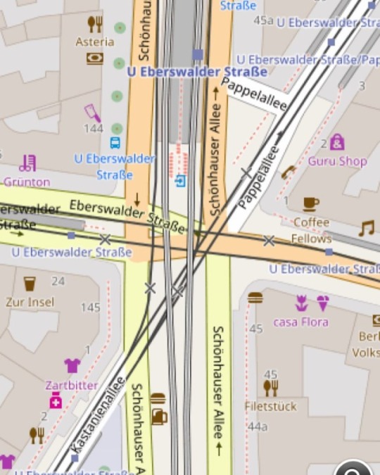
I love it. So many details on the openstreetmap.org map. I don't use googlemaps. I'm not trusting google. . #drmotte #openstreetmap #map #openmaps #berlin #kastanienallee #pappelallee #schönhauserallee #eberswalder #danziger
#pappelallee#openstreetmap#drmotte#schönhauserallee#map#berlin#eberswalder#danziger#kastanienallee#openmaps
0 notes
Text
@cerchio @thenorthern credo che openmap possa fare qualcosa del genere.
@cerchio @thenorthern credo che openmap possa fare qualcosa del genere.
@cerchio @thenorthern
credo che openmap possa fare qualcosa del genere.
View On WordPress
0 notes
Last Seen Blogs

duelingnebulas
DuelingNebulas/ GoldBlooded

panache557
Untitled

drarrydorks
The Blonde Gay And The Oblivious Bisexual

aerobatics-unlimited
Michael Thompson

incorrect-transformersprime
incorrect transformers prime