#they even cross the highway on the main street through the commercial part of town at night
Text
The solar eclipse is gonna happen on the 8th (also happens to be my mom's birthday) and people are already coming in from out of town and it's gonna be really funny because they're predicting it's gonna be completely overcast during the eclipse lol
Like our town is one of the ones in the totality line and is the second (or third?) smallest town on it and we have a total of two motels and one hotel (if you can call it that) and theyve been booked solid for these two weeks since like January. These people are gonna be bored as fuck for the next week. I've lived here for almost three decades and I've never been not bored. The only stores that are still open in the "historic downtown" are the Dollar General, a shitty antique store and the hookah store with the Cheech and Chong gnomes in the window. Closest thing we have to a restaurant is Whataburger.
I saw a family pulled over on the side of the road yesterday all crowded around a tiny patch of Bluebonnets taking pictures, which was just really funny to me because around the corner was an entire field of them and I'm like oh boy when they drive another mile they're gonna lose their fucking minds.
I guess if they get excited about wildflowers then they might not be so bored after all. Just hope they watch the roads while they're driving. 🫣
#like im not one to be boooo out of towners are the devil boooo but also none of these people know how to drive#im assuming most of them come from places where they use public transport and im honestly jealous#none of them are prepared for the sheer number of deer that move around here at night#they even cross the highway on the main street through the commercial part of town at night#do you know how funny it is to see deer eating all the trees they planted in front of mcdonalds#just glad i live a mile away from the main town oof
10 notes
·
View notes
Photo
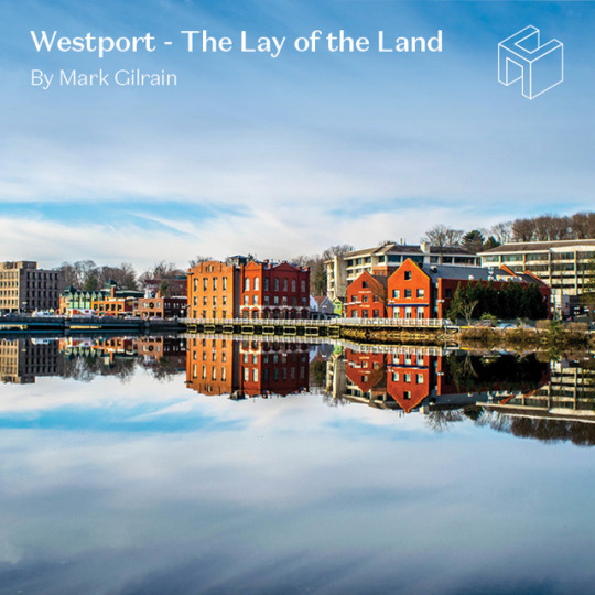
Westport: The Lay of the Land
By Mark Gilrain, Lic R. E. Salesperson in our Westport office
The phrase “lay of the land” characterizes a mental map used to keep physical or conceptual geography organized in one’s head. I have a mental model of Westport, a town of 24.2 square miles shaped in a skewed square and found in Fairfield County, Connecticut. The town feels expansive even though it's slightly smaller than each of its neighbors and many of the other towns in the county. Here's a description of the mental model I use for Westport. It helps me, and I hope it helps you, too.
The Natural Dimension
Naturally speaking, Westport has always been the combination of a few landscapes: the rising banks of a clean Connecticut River, a modest glacial plane of lower and leveler topography, sandy or pebbly beaches, wooded wetlands, and a northern stretch of rising sometimes rocky hills. Think of the northwest and northeast corners as high points in town with vantages for looking out across the rest.
Situated as a coastal town on the Long Island Sound, the waterfront sets up a natural backdrop that infuses the vibe of the town. Boating, beach-going, and polar bear swims are all part of the scene.
The coastline itself is both smooth and uneven. It spreads for long smooth or curved stretches in some places but also is made interesting with inlets and projections, a river and several creeks, and a salt marsh or two. Several large islands extend Westport out into the water as well.
The Saugatuck River
After the coast, an immediate feature of note is the Saugatuck River. Large enough to require a towering bridge to carry Interstate Highway 95 and a slightly less towering bridge for the Metro North Rail-line, it is also small enough to be crossed locally by an historic iron-trussed bridge and by a flag-strewn bridge in the center of town. As wide and substantial as it appears at its mouth – where the current flows out between the town’s waterfront country club on one shore and Westport’s Saugatuck Shores and Saugatuck Island neighborhoods on the other – by the time it has tracked north past Saugatuck Center and the center of downtown, it virtually disappears. Here, the several feeder rivers and streams branch off in a variety of directions and disappear into a hilly and woody landscape.
North-South in orientation, think of the river as dividing Westport into east and west sides. The river doesn’t flow through the center of Westport but moreso divides the town at the three-quarter mark. The east side of town stretches farther to the Town of Fairfield line than the west side does in reaching to touch Norwalk.
The Islands
Of the major islands, the first of note is Saugatuck Island mentioned above. It’s reached from town circuitously from a back road that connects Westport to East Norwalk Center. The island isn’t quite a true island as a canal stops just short of severing the island entirely. Though it is an out-of-the-way place to live, the island and the protrusion of land that connects it are populated by dozens of streets filled with bungalows and beachy homes both casual and lavish.
The second island of note is Sherwood Island. Just over 235 acres, it is a state park – Connecticut’s first, in fact. It offers summertime beach amenities, weekend races and walks, a hobbyist air field, and a spot where a groundhog or turkey might be spotted while walking your dog. While central to the town’s coastline, it is cleverly situated at a remove from the rest of town – resulting in its being nearby while the remainder of town is utterly buffered from its visitors.
The Man-Made Dimension
The second dimension of the town is the man made one: the development, the zones, and especially the roads. The roads tell the story of how we all get around.
When building a mental map of the roads, you can put the coastline and the river down a few notches in how helpful they are to building a sure sense of one’s bearings for the day-to-day.
The Post Road
For day-to-day mastery of Westport geography, 50% of it comes back to one road: the Post Road. Traversing Westport from east to west, it travels across the whole town lined by offices, shopping centers, supermarkets, condominium communities, and a variety of commercial elements. Everything in Westport is either “north of” or south of” the Post Road.
Building from the Post Road, almost every main north-south artery radiates north-south from here. Two of the most helpful to the mental map are Compo Road and Riverside/Route 33.
Compo Road
While Compo Road does not technically bisect town, it figuratively feels that way. The point where it crosses the Post Road feels like a veritable center – a traffic island carries a majestic sentinel, a grand Sycamore, with her spanning crown of dinner plate-sized leaves.
From this cross-road heading eastward, the Post Road bulks up, hitting double lanes in each direction, as well as higher speeds and lots of commercial choices. Turn west from the Compo crossroads and it’s a quaint sidewalked downhill to the center of downtown, shops, restaurants, playhouse, library, performance pavilion, and more. The Ruth Cohen Steinkrauss Bridge is a wide, low visit with the river before climbing again to charge off past Old Hill and then more shopping centers en route to the town line.
As for Compo Road itself, it travels south all the way to the main beach in town. Going north it hits the heart of the north end of town where it feeds a multitude of roads that head to any corner you desire. Of these, a most notable byway is Cross Highway which parallels the Post Road in the residentially less dense north quadrants of town. Cross Highway passes a few fields, forests, and marshes but most notably connects to every major northbound road on the east half of town.
Riverside Avenue
On the west bank of the Saugatuck, Riverside Avenue serves as a north-south artery in a more heavy-duty way. Traffic is heavier and moves faster. Going south it picks up I-95, Saugatuck Center, and the Westport train before heading down toward Saugatuck shores and then Norwalk beyond.
Heading north, it feeds several access points to the bucolic and affluent Old Hill, and the stately and private Red Coat neighborhoods. It’s also the route to Westport’s state-of-the-art Westport-Weston Family Y center and picks up the Merritt Parkway ramp before traveling off to parts of Norwalk and Wilton beyond.
Other Roads of Note
What’s the shape to keep the three roads above straight? I think of a giant “H” sloppily drawn by a five-year-old just getting their letters down. The upright lines are somewhat bendy and each might start or end randomly above or below the other. And the H’s cross starts way before the uprights and goes on a long way after as well.
There are a lot of other useful roads to add in once the H is nailed down. Greens Farms Road traverses the whole south side of town. Cross Highway traverses the North. Long Lots and Hillandale parallel the Post Road nearby.
To travel along the shore, use Beachside, Soundview, Duckpond, or Harbor. Imperial leaves downtown heading south and ends up at the Cribari Bridge serving as a second popular route to the train. Main Street leaves downtown going north eventually crossing and picking up the top of Compo Road.
The big names when it comes to going north and south on the east side of town are Sturges, Bulkley, Maple, Bayberry, Turkey Hill, Morningside, Hillspoint, and Roseville, in that order. On the west side of town things are a little more curled all around.
Leaving Westport
Of course, there do come times to leave Westport. The Post road is great for going east or west obviously, and of course one of life’s great conveniences is highway access. Westport offers four: two each to I-95 and Merritt/15.
Also, nicely benefiting from New England tradition, more than a few roads also go “over the river and through the woods” to a neighboring country town. How nice that they are all named for the town they set off for: Wilton Road, Weston Road, Easton Road. The names never leave one wondering where one might be headed.
The roads don’t tell the full story of getting to and from Westport, however. There is the train line as well. Metro-North Railroad serves stations at Saugatuck Center and at Greens Farms offering commuting and excursion options to NYC and the rest of the service area.
As someone working with buyers, I share this mental model conversationally every day. It helps people feel anchored as we visit properties and learn about different neighborhoods in the town they will soon call home.
0 notes
Text
On California’s Lost Coast: Sea Lions, Surf and Squiggly Roads
On a deserted beach in Northern California, I mistook a sea lion for driftwood. The Lost Coast is deceiving that way. Wild things appear tame and tame things, like the paved road my family and I took to get here, wild.
In June, seeking immersion in nature, we visited the Lost Coast, the largely roadless shore between the indiscernibly tiny town of Rockport and the Victorian charmer Ferndale, about 100 miles apart by inland roads. Here in Humboldt County, California reaches its westernmost point near a junction of three seismically active tectonic plates. The King Range mountains plunge into the sea, deterring road-builders from continuing State Route 1 along the ocean. Breaking waves strew driftwood along beaches reached by hiking trails that require consulting a tide chart. It’s cold and foggy, even in summer, and just rough enough to keep all but the most intrepid day-trippers away.
“No one comes here without intending to come here,” said Verna Kaai, the manager of the Tides Inn, a homey base in Shelter Cove, the oceanfront gateway to the Lost Coast, when I booked a room for three days amid a weeklong road trip. “We’re only about 20 miles from the highway,” she said of the squiggly access road that connects the town to the nearest thoroughfare, “but it will take you up to an hour to travel.”
That sounded like our speed. And while the coast wasn’t lost to the Native Americans, loggers and cannabis growers who have left their mark here, it appealed to us in another escapist sense: little connectivity. Ms. Kaai assured me I wouldn’t have cellular service, though the hotel had very slow Wi-Fi. In this screen-centric age, a few scenic and relatively unwired places remain in the United States, such as Organ Pipe Cactus National Monument in southern Arizona and parts of the Adirondack Mountains in New York. But this slice of California’s coast — only some 225 miles north of San Francisco — seems, well, lost in plain sight.
A harrowing drive
Long before it went missing, the area was populated by Native American Sinkyone and Mattole people, and later, lumberjacks and harvesters of tanoak bark, used to tan leather. The Gold Rush in the mid-19th century brought more settlers, and logging intensified in the race to rebuild the city after the San Francisco earthquake in 1906. Churning seas tended to wash out piers, which killed most attempts to fish commercially in the 19th and 20th centuries. In 1970, after the timber industry had depleted much of the area, and depopulation drew pot growers, the 68,000-acre King Range National Conservation Area, which protects 35 miles of coast and mountains up to 4,088 feet, became the country’s first National Conservation Area.
Now, visitors come to the Lost Coast to hike, fish, beachcomb, bird-watch and scan the ocean for migrating whales in the offshore marine preserve (Ms. Kaai recommended visiting on a weekend, when Shelter Cove’s few restaurants are open). Others come to backpack along the famous Lost Coast Trail-North, a nearly 25-mile beach trek that generally takes three days, requires a permit (free, with a $6 reservation fee) and is subject to tides that periodically make portions impassable.
Like the hiking here, driving to reach the Lost Coast requires a degree of fortitude. The builders of California’s Highway 1, which skirts the Pacific from Orange County more than 600 miles north, gave up the shore plan at the King Range, a topographic accordion we glimpsed in hazy fog and spray before veering inland. It ends at Leggett, about 15 miles from the ocean, funneling drivers onto U.S. 101, which continues north through southern Humboldt County before rejoining the coast near Eureka.
From the U.S. 101 exit at Garberville, 23 miles from Leggett, the route to Shelter Cove turned westward and challenging. For the next 50 minutes of concentrated driving, my husband, Dave, worked hard to maintain 35 miles per hour winding up mountain ridges and through dense fir forests, and downshifting at the continuous switchbacks to avoid overheating the brakes. Past the town limit sign for Shelter Cove, population 809, I finally relinquished my clutch on the Jeep door handle at the ocean panorama of surf-bashed rock islands and mountain-backed beaches.
Shelter Cove, at last
On the southern end of the Lost Coast Trail-North, Shelter Cove is scattered across a largely treeless peninsula that protects the town’s namesake, a south-facing cove. A general store on the access road deals groceries and hardware in the absence of any commercial main street in town. Modest houses dot the shore, leaving plenty of gaps for places with names like Seal Rock and Abalone Point, and views to the sea from most vantage points, including a campground and a lightly used nine-hole golf course. The closest thing to a town square is the community center, which, when we visited, was holding a group garage sale near the landing strip that parallels the coast.
Between the runway and the sea, the location of the eight-room Tides Inn — a three-story cross between a motel and a McMansion that is perched above a cove and hugged by rocky arms — exceeded our expectations. Our suite was thoughtfully furnished with nautical décor in the bedroom, a kitchenette nook with a mini-refrigerator and microwave and a high-top dining table. But the views made you forget about anything indoors. From our third-floor balcony, we could hear sea lions barking each morning and watch sunsets late each evening.
While it remains a destination for lovers of isolation, Shelter Cove has added a few tourist-friendly essentials in the past year, including a brewpub and a Venezuelan restaurant, Mi Mochima. On our first night, we followed the music across a ball field and skirted the unfenced landing strip to find Gyppo Ale Mill, a microbrewery, which takes its name from independent timber crews who came to Northern California to fell big trees (some logging remains, though environmental activists are fighting to preserve one of the region’s remaining old-growth Douglas fir stands, known as Rainbow Ridge). On this Friday night, the local band Planet 4 played funky tributes to Dr. John, who had recently died, and children ran circles around a cornhole-playing field.
Like us, the Gyppo Ale Mill’s co-owner Julie Peacock took one of the dramatic drives to the Lost Coast region and immediately fell in love with it. In 2001, she and her husband, Josh Monschke, whose family has roots in Humboldt County logging, left ski resort jobs in Utah to move to the area to farm marijuana, and he continues to run a nursery. They opened Gyppo last spring and call it “California’s most remote brewery,” because, said Ms. Peacock, “I haven’t found one more remote.”
We felt we’d earned an I.P.A. or two, after the harrowing drive in, but learned that’s not an excuse used by residents.
“Locals think nothing of driving that road to town,” said Katie Wallace-Schmidt, the manager of Gyppo as she delivered falafel burgers and lamb sausage to our table. “In L.A., I could easily be on the highway for 50 minutes to go 10 miles. I’d much rather be here.”
A dose of wilderness therapy
Given the weather, which generally peaks in the 60s in summer, we didn’t consider Shelter Cove a swim destination, though we found hardy bathers dipping into the shallows at Cove Beach on Saturday morning. By afternoon, a dozen SUVs and pickup trucks were parked on the popular beach, a rare safe place to swim along the Lost Coast, which is known for its rip currents and shore-breaking waves.
If not a traditional beach-lovers’ shore, the Lost Coast is ideal for losing time climbing over craggy rocks and inspecting tide pools. Between hikes in the conservation area, we scrambled around the peninsula’s rough edges, watching whistling oystercatchers, turkey vultures with their wings spread to dry in the sun, and sleepy harbor seals, some of them still pale in their juvenile coats (a notice posted in the Tides Inn window warned visitors from getting close to the pups, which are often alone and mistaken for orphaned while their parents, who may abandon their babies if in the presence of humans, are out fishing).
The Bureau of Land Management, which oversees the King Range preserve, allows 60 overnight backpackers per day to depart on the Lost Coast Trail-North between May 15 and Sept. 15 (30 people per day are permitted the rest of the year, when worsening weather notoriously alters and sometimes washes out parts of the trail). Day hikers do not need a permit. On our visit, the Shelter Cove trailhead parking lot was full, with more than two dozen cars, and a nearby street was lined with the overflow, indicating the numbers of hikers somewhere along the coast. Still, we felt we had the trail to ourselves Saturday morning, along with a black bear, possibly, based on the fresh scat we encountered.
From the Shelter Cove trailhead at Black Sands Beach, the going was slow on spongy black sand and tumbled sandstones that were hard to grip as our boots sank inches with each step. The slow pace that beach hiking enforced worked as wilderness therapy. We combed the high-tide line, finding patterned sea urchin shells, sun-bleached sea stars, driftwood sanded by waves and the occasional crab trap. Near the breaking surf, we nearly bumped into a juvenile sea lion we mistook for a log. We took breaks atop 20-foot high boulders that appeared to have tumbled from a mountain peak with an evident rock slide on its oceanfront face (the offshore Mendocino Triple Junction sets off frequent tremblers in an area where the three tectonic plates meet). Massive timbers made sturdy bridges to cross mountain streams that run down the slopes and cut through the sand on their way to the sea.
Venezuelan fare, blind curves and a tiny lighthouse
That night we gorged at Mi Mochima, a sunny new Venezuelan spot with its own boomerang story. The married owners, Blu Graham and Maria Graham Diaz, met in Venezuela where he was a scuba-diving guide. In 2011, after moving back to the coast where he grew up, Mr. Graham opened the neighboring Lost Coast Adventure Tours, which offers guided backpacking trips on the trail. The ocean-view A-frame restaurant, where Ms. Diaz is the chef, is designed to balance out their seasonal business, offering mini fish empanadas, garlic-sautéed prawns and a hearty shredded beef stew known as pabellón criollo. Our waitress, the couple’s adult daughter, Indiana Graham, explained that the coastal town of Mochima, Venezuela, and Shelter Cove are only distant in a geographic sense.
“They both are all about the ocean,” she said.
Getting to the northern trailhead at the Mattole River the following day was the most extreme of our adventure drives. Our innkeepers recommended a paved route largely outside of the conservation area that still turned out to be a hair-raising, one-hour, 40-minute errand on narrow roads that occasionally pinched to one lane, often, it seemed, just as we reached a blind curve (Lost Coast Adventure Tours, also offers shuttle service to the trailhead in 11-passenger vans).
A series of determined roads ascended pine-dense hillsides, undulated over mountain passes of wildflower meadows and tunneled through trees, only to descend and make the climb all over again. The few towns indicated on the map were easy to miss, though the general store in Honeydew, a blink of a town where a few intriguing back roads intersect, was thronged with dirt bikers on a group drive. We passed through sleepy Petrolia, site of the first oil well drilled in California, and took the relatively flat Lighthouse Road that follows the tail end of the Mattole River to reach the Lost Coast Trail at its top end.
In contrast to the pine forests around the southern trailhead at Shelter Cove, grassy woodlands border the northern gateway. Desert wildflowers, including globe-shaped yellow sand verbena, daisylike purple fleabane and violet lupine, bloomed in the dunes. A deer grazed a hillside and sea lions on offshore rocks barked at our approach. At just over three miles in, a colony of elephant seals dozed below the squat, white Punta Gorda Lighthouse, a remote, long-decommissioned beacon anchoring a grassy hillside above the shore.
Leaving the Lost Coast northbound saves one of the best adventure drives for last when, past Petrolia, two-lane Mattole Road links to the coast again and follows an undeveloped stretch. Bushy wild radish plants crowded the road as it climbed inland and, 90 minutes later, abruptly disgorged us in Ferndale, a manicured Victorian-era Mayberry. There, a ukulele ensemble was jamming in a bank parking lot, a comparatively found spot — with cellular service restored — at the border of the lost wilds.
Elaine Glusac is a frequent contributor to the Travel section.
52 PLACES AND MUCH, MUCH MORE Follow our 52 Places traveler, Sebastian Modak, on Instagram as he travels the world, and discover more Travel coverage by following us on Twitter and Facebook. And sign up for our Travel Dispatch newsletter: Each week you’ll receive tips on traveling smarter, stories on hot destinations and access to photos from all over the world.
Sahred From Source link Travel
from WordPress http://bit.ly/30KSLQV
via IFTTT
0 notes
Text
Zàyera City (Citè du Zàyera)
Zàyera City is the largest city on North Zàyera Island. It is the most pivotal city where just about anyone is welcome whether they are an Earth-native, a Zeraithe, or an extraterrestrial from another world. There are many prominent people and locales that reside in the City of Dragons. The city primarily consists of three major neighborhoods: the North City Development, City Center/Downtown, and the South City Expansion.
The North City Development is what can be described as groups of housing projects that have since been blighted. The City has since moved to condemn these blights, but there are residents who call these dilapidated structures home. It is a prime location for felonious crime.
Still within the NCD, the medical pride of the island was first built as a complex on the highway route leading out to Èiyaure County. Over the years since the 1940s the Zàyera Medical Complex was the central point for local medical research. Gradually, the older, outdated medical center was shuttered. However, one building stands out among the derelict complex: the Zàyera Institute for Children’s Mental Health—simply, CMH.
Children’s Mental Health is not an insane asylum for mentally ill children, rather it is a research observatory. Patients are received on a temporal basis for up to 14 days as allowed by state law—for special cases, 21 days. Two most prominent people have been patients at the facility. The previous Prince Zàichad Èiyaurëc and previous Blaize fortune heir Dràzden Auèserëc have been under the observation of renown psychologist Dr. William Raymond. Dr. Raymond of British descent had come to Zàyera to study the mental capacities of Zeraithe people, particularly the children. The CMH would just be another nameless building if it had not been for the orphan scandal it has suffered.
In the 1970s, the young Dr. Raymond had a hand in taking orphans from the nearby Celestic Gardens Orphanage. Within CMH, the basement (and sub-basement), seventh floor, and eighth floor were off limits to all staff except Dr. Raymond and his team. On those floors are machines and laboratories that specifically targeted forced mind alteration. It happens that children’s curiosities would start the evil ball rolling and the “wizard behind the curtain” is revealed.
This in turn leads to Celestic Gardens Orphanage in the NCD. The orphanage is a city-run facility for children up to 18 years old. The director of the orphanage was Griselda Gerard. Of course, in the 1970s and ‘80s lax oversight was apparent as Ms. Gerard ran the place like a fortress. Within, the teenage orphans ruled asserted their dominance over the younger children. Outstanding residents of the orphanage are Romayne Trevelyan, Sean Farrell, and Drake Cassidy. A few points about Ms. Gerard is that she was heavily vested in the occult and drugs to even worry about those she in charged to protect. Even the toughest of orphans cower in her presence when she is enraged. Years after her reign, Romayne, Sean, Drake, and other orphans lose their will to fight against her ingrained power, often reverting into a sense of subservience. A side note is that no orphans at Celestic Gardens are Zeraithes.
South of the North City Development is the City Center and Downtown. Wealth seems to grow as one drives from north to south. Herein are buildings of increasing height and multitudes of mirrored glass. Only one of these immense towers dominates the other market-seeking offices: Blaize Corporation Tower. Blaize Tower, for short, is the commercial stronghold of the nation’s most wealthy individual, Dràzden. He is the brute rival of the royal King Zàichad. Speaking of royalty, the majestic Zàyera Castle lies low among tall giants. It is a fantastical marvel that invokes the stylistic approach of fairytale castles rather than practical defense. It’s youthful, unblemished splendor is wasted as no sitting king or queen has seated there since the 1200s AD. The audience room is littered with modern, brown cardboard boxes of many sizes as if it were a lowly storage closet. The castle is unique in that it is fully constructed from materials imported from planet Zerài, the Zeraithe homeworld—no Earth-based cannon fire or ballistic missile can scratch Grand Zàyera.
Leaving finance and government while still downtown, there is entertainment. Plaize Khèntrico is a high-end outdoor mall situated around none other than Blaize Tower. While the plaza hosts expensive doodads at elegant boutiques, it also hosts extravagant bars and nightclubs that cater to just about every taste—there is entertainment for straight-seeking individual as well as those catering to the LGBT community. By LGBT, there is something for Tali Rathàniel, Dràzden’s business partner and best friend, to self acquaint himself with. Along with entertainment, there is sport. That is where the L’Aquila Dome comes in. The national sport of Zàyera is Luche! La Luche da la Championades de le Mond or Luche or LCM for short is hosted by Zàichad himself at the L’Aquila Dome. It is the most televised sport in the country, or else! The sport can be seen as a form of professional wrestling which includes its own brand of kayfabe.
Downtown cannot be fully witnessed if one were not to be educated. The scholarly Academie Auränd, simply known as Auränd Academy, has its campus a few blocks from the L’Aquila Dome. The school is situated in the Zàyera City School District; it is a public school without tuition. It is comprised of buildings for an elementary, a junior high, and a high school. The school still maintains its boarding houses, but it no longer boards students. Surrounding the mandatory school site is the Auränd State University at L’Aquila. University research comprises of Zeraithe studies in their magic system as well as their biology. By law, only ASU-LA can maintain such endeavor. One last thing is that ALL Zeraithes must take the Academy Exam even if they school elsewhere; if they do well, they get their name chiseled on the alumni wall at Main. To date, neither Zàichad nor Dràzden have attempted the exam, presumably their associates also.
As was said, the further south one goes, the more opulent the neighborhoods. The streets of the South City Expansion begin to line with large, needless living spaces. Well groomed lawns and parks mix in with classic hanging lantern shaped street lights. The Hill family residence is located in this neighborhood. Both Dane Hill and Kevin Hill made money off of their differing inventive ideologies. Kevin relies on genetic research, whereas Dane favors practical and useful tools. The Hills are both “unnatural” prodigies possessing superior intellect. Some other residents of the SCE are Zydanon O’Rourke and Wyzaron de Cerdaña both inheritors of separate family estates. The powerful women of Zàyera can’t go without saying Anastasia Remington’s name. Her family made their gold with the exploitation of alien artifacts.
In the SCE among the mansions and overly dressed convenience boutiques sits the Zàyera Center for the Gifted Intellect of Man. The CGIM is a place where Earth-native intellects can gather and share their insights of gifted knowledge. The building is distinguished by its cubic, neo-modern design in bright white; it is tucked away behind the mansions and gardens, seeking to be hidden from prying eyes. They do not allow extraterrestrials, including Zeraithes.
The city is not static with just its outstanding sights. Its people must be able to get around town and out of it. The city boasts a robust and reliable public bus system that runs just about every corner of the county as well as commuter end-of-lines at Èiyaure City and Auèsere City in their respective counties. Differently to the likes of New York City and Tokyo, taxi service is publicly owned and run in cooperation by the county and city government. The vehicles can go just about anywhere that the bus routes don’t allow. Of course, there is no law or ordinance prohibiting car ownership. A multi-lane freeway glides through the city as part of its journey to South Zàyera Island. The freeway also services the six other counties before crossing over the Ren Zàyera Bridge to Italy state. A little tidbit about the freeway is that it intentionally misses the other county seats in order to preserve their small town quaintness.
Rail, especially light rail is huge in Zàyera City. The city prefers light rail to metros or subways. The many lines criss-cross the city to provide expedited service to major transit hubs near big name sites such as Plaize Khèntrico, Celestic Gardens, Manior Roidane, and points in between. Expensively, the light rail was expanded to Èiyaure City (Èiyaure Line and Z-Line) and Auèsere City (Auèsere Line and D-Line). Both Zàichad and Dràzden had to provide private financing to the outlying lines. Freight and commuter rail run near the freeway to provide rail access to and from the island. The bridge to Italy contains a set of two way rails run between the car route.
Flight service is provided by Zàyera City International Airport in Khètzade County on South Zàyera Island. The city’s growth is ever flowing through to the southern island. Flights arrive from and depart to national destinations such as Rome, Paris, or Madrid to international ones such as New York City, Moscow, Cairo, or Tokyo. In 2001, both Auèsere County and Èiyaure County have become “No Fly Zones.”
Boat and ship service are also prevalent for an island environment. The city maintains commercial docks along its western seaboard up until they are zoned for recreational boats around the SCE. However, travel to and from Malta Island Research Center is restricted to special docking stations at government reserved docks located ONLY in Zàyera City. Departing from any other dock around the island for Malta is a crime against the royalty. Malta Island is similar to the hush-hush of United States’ Area 51; it is heavily guarded.
In 2002, the city opened its first spaceport in Khètzade County. Authorized personnel from the Galactic Federation use the spaceport to safely land their smaller scouting craft to deliver guests and trade materials. Earth-natives may enter the spaceport and the landing zone areas, however, they are not permitted to board a chartered (departing) craft. They may tour such crafts, but only if the craft’s owners allow it. Permission to land must be granted for hostile craft by order of the King of Zàyera (Zàichad) only; further, Earth-natives must be evacuated from the premises prior to landing.
Law enforcement is provided by the Zàyera City Police Department. Ironically, there are Dragon Thieves that head up some of the local precincts. These “thieves” are only known because their name marks them as an ancestral line of the old world thieves. The judiciary goes for a few courts before it reaches the Cèduai—the Thieves’ Court (as opposed to the Royal Court of Law under former King Fèrelon Zàyeralt). Law and ordinance creation is by elected city committee, then contested or approved by the King of Zàyera by option (doesn’t matter if it were Fèrelon at the time or Zàichad currently).
0 notes
Text
The Not-So-Deadly Real Life Locations of Hakata Tonkotsu Ramens
I’m sure glad that I'd already visited Hakata last summer before watching Hakata Tonkotsu Ramens, as I’d now think twice before setting another foot in the ominous port city. While Hakata seems like a vibrant and bustling metropolis at first glance, the city boasts a rampant criminal underbelly, where a full three percent of the population are supposedly hitmen. To quickly put that in numbers: The Hakata Ward alone has a population of 228,000, which would make 6840 of them ruthless contract killers. Looking at the bigger picture, the Hakata Ward is part of Fukuoka City, which would mean that roughly 46,519 people out of 1,550,626 kill for a living, and let’s not even get started on the Fukuoka metropolitan area. With that many hitmen casually going about their business in the city, every sip of the delicious Hakata ramen might as well be your last.
Luckily, Hakata isn’t nearly as murderous in real life as the anime makes it out to be. Japan in general has one of the lowest crime rates worldwide, and Hakata and Fukuoka are no exceptions to that, so you don’t actually have to worry about your wellbeing while slurping down your ramen. Putting all the brutal crimes and eccentric hitmen aside, Hakata Tonkotsu Ramens’s portrayal of Hakata, which is that of a young and dynamic city, is actually quite accurate. And as always, all the locations shown in the anime also exist in real life, so let’s take a look!
*Pictures not marked with ‘WD’ were taken with GOOGLE STREET VIEW
WD
Hakata is now part of Fukuoka City after a merger between these two former towns in 1889, but Hakata still remains the name of Fukuoka’s central districts. The town is located on the northern shore of Kyushu, Japan’s southernmost main island. Just like in the anime, the Hakata Ward is a hip and dynamic commercial and entertainment district, although without all of the kidnapping, strangling, and torturing you see in the anime. Pictured above is the city’s Naka River.
Wikipedia
It’s also along the Naka River and on Nakasu Island, where you’ll find a good number of Hakata’s famous food stalls (Yatai), good place you can eat local dishes, grab a few drinks, and chat with total strangers. Banba is a regular visitor, and even receives his killer contracts here from Gouda, who runs one of the stalls along the river to keep a low profile.
The Banba Detective Office also exists in real life, in a side street behind Hakata Station. However, the actual building does not house a detective agency, but a chiropractor instead. At least that’s what it says on the outside.
Only a few steps away is Hakata Station, which serves as the gateway to Kyushu thanks to the Shinkansen.
In all fairness, I'd probably make the same face as Saito here if I were about to move to a city where three percent of the population might put a knife in my back at any given moment.
WD
WD
I was already cutting it close, but still wanted to take this shot of Hakata Station during my visit last summer, as the same shot also appeared in one of my favorite anime, The Pet Girl of Sakurasou. Sorata brought along Nanami, Mashiro, and Misaki to his hometown during their winter break in episode 15.
The street leading up to Hakata Station.
Bar Babylon, from where Jiro runs his own hitman avenger agency, also exists in real life. For some reason, the bar only seems to be getting customers who are hitmen themselves.
Aside from being a private detective and killer for hire, Banba also loves to play baseball, so a batting center was bound to show up sooner or later.
Tenjin Core is a large fashion department store in the city, geared mainly towards teenagers, young adults, and cross-dressing hitmen like Lin.
Unfortunately for Lin, the Tenjin Core department store was also the place where he got the news of his sister being kidnapped.
So in return, the capture of the major’s son was also streamed on of the huge TV screens around the department store.
Fukuhakudeai Bridge crosses the Naka River and connects Nakasu Island to Nishi-Nakasu.
Situated at the southern tip of Nakasu Island is the small Seiryu Park here, right next to the famous lane of food stalls.
And located just across from the small park is the city’s standout shopping and entertainment complex, Canal City Hakata, which has an artificial canal running through the whole complex. It’s also one of Lin’s favorite places to shop.
Another well-known landmark of the city is the Hakata Port Tower, which is also prominently featured in Hakata Tonkotsu Ramens’ opening and ending. The observation platform overlooks Hakata Bay and is actually free.
It has become somewhat rare for anime to deviate from their real-world models, but for some reason, Hakata Tonkotsu Ramens decided to leave out the second highway in this shot.
And lastly, the latest episode also marked the start of Banba’s long-awaited Hakata Gion Yamakasa Festival. Just like in the anime, the actual festival takes place every year from July 1 to July 15 in Fukuoka, dating back almost 800 years. In the Oiyama event on the last day, seven teams, one for each neighborhood in Hakata, take part in a time trial race through the city. They do so while carrying a five meter tall and one ton heavy float, called Kakiyama, around five kilometers through the streets of Hakata as fast as possible.
The race begins at the festival’s host shrine, the Kushida Shrine.
WD
And to top off the article, here’s a snapshot of actual Hakata ramen that I ate in Hakata.
Have you been keeping up with this season’s cool and cold-blooded crime drama? What are your thoughts so far? Sound off in the comments below!
---
Wilhelm is an anime tourist, who loves to search for and uncover the real-world spots he sees in anime. You can talk with him on Twitter @Surwill.
0 notes
Text
After the killings, shock and grief in a small Texas town
yahoo
SUTHERLAND SPRINGS, TEXAS—It was one of those towns where everybody knows everybody, seemingly far removed from the violence that stalked big cities, where you could leave your front door unlocked and the sound of gunfire signified recreation and not a cause of concern.
But then came Sunday morning, when a man in black armed with an AR-15-style semi-automatic rifle showed up at the First Baptist Church. Moving methodically from pew to pew in the tiny sanctuary, he slaughtered half the congregation in a matter of minutes. Survivors describe him hovering over weeping women and crying children, firing hundreds of rounds in an effort to extinguish any sign of life. The local sheriff who was one of the first on the scene initially couldn’t distinguish the 26 dead from the nearly two dozen wounded.
Suddenly, on Monday, Sutherland Springs, this tiny town on the dusty back roads of south Texas that few people had ever heard of joined Newtown, San Bernardino and Oklahoma City on the roll-call of modern American atrocities. This one-stoplight town about 35 miles southeast of San Antonio where everybody knew everybody was suddenly full of strangers, swarmed by hundreds of reporters who parked their rental cars and satellite trucks on every foot of land for a half a mile in every direction from the only major intersection.
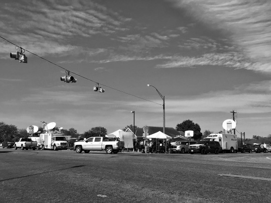
Media trucks crowd the only major intersection in Sutherland Springs, Tex., a tiny, one-stoplight town that was the site of Sunday’s mass shooting. (Photo: Holly Bailey/Yahoo News)
Grief counselors descended on the area to offer comfort to those in need, but like reporters, many wandered around the few square blocks of the town, much of it behind yellow caution tape, unable to find any “real people” to talk to. Volunteer agencies, like the American Red Cross, showed up in motorhomes ready to render aid, but most workers stood around, looking at their phones for the latest information and talking to members of the media.
“We’re here to help, but it seems like the only people here are reporters,” a counselor with the Billy Graham Ministries who had driven from Dallas, five hours away, told a reporter outside the VP gas station, two blocks from the church and one of just four commercial businesses in town.
Across state Highway 87, the main route through Sutherland Springs, there was a post office. That was next door to the Valero, the other gas station in town, which sits directly across the street from the First Baptist Church. A block from there was the Dollar General, where the parking lot was full of TV reporters doing live shots. The rest of the area was rolling farmland, dotted with the occasional trailer and ranch house.
“This is a small place, which is why you can’t wrap your mind around something like this happening here,” said Lorenzo Flores, who, along with his girlfriend, Terrie Smith, owns a restaurant inside the Valero gas station across the street from the crime scene. “You can’t make any sense of it, no sense at all.”
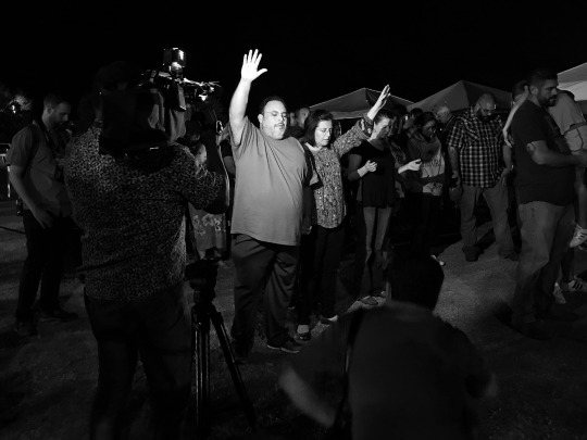
Photographers film a couple praying during a memorial service held Monday night in Sutherland Springs, Texas. (Photo: Holly Bailey/Yahoo News)
Those residents who did emerge were swarmed by reporters who thrust cameras in their faces to capture every word and tear. What did they see? Did they know any victims? How will the town recover? And increasingly, throughout the day, there was the trickier question, particularly for a region where firearms are an integral part of the culture, like going to church and watching football: Should there be new limits on guns to prevent anything like this from happening again?
It was a subject that many here waved off, both residents and local officials, saying it was too soon to talk about as the community recovers from the shock and grief of an attack that affected nearly everyone in this small town of roughly 600.
But those who did talk about it suggested that one lesson of Sunday’s massacre is that more guns seemed to be the answer—not less.
On Sunday, Stephen Willeford, a former NRA instructor who lived across the street from the church, grabbed his rifle when he heard gunfire coming from the sanctuary. He ran outside and began firing at the gunman, identified by police as Devin Patrick Kelley, wounding him at least two times and forcing him to drop his weapon and flee the scene. He and another man, Johnnie Langendorff, pursued Kelley in a high speed chase that ended with the gunman crashing in a field about 10 miles away. Local officials have called Willeford “a Texas hero”—saying he likely stopped Kelley from enacting more carnage.
On Monday night, Willeford, who gave a single local television interview but has otherwise shunned the reporters, was greeted with tears and hugs as he arrived at a memorial service for the victims at a ballpark a few blocks away from the church.
yahoo
“People will say you should ban guns like the one that was used by that killer,” said Raymond Martinez, a former resident who returned to town to mourn the victims. “But then the neighbor probably wouldn’t have had his gun and who would have stopped (Kelley) from killing more people?”
Freda Connolly, who lived a few blocks from the church, said she felt dread thinking about a religious sanctuary, a place that should have a feeling of safety and peace, now disrupted by fear. She didn’t necessarily like the idea of people openly carrying guns or seeing police or armed security guarding the doors.
But after this, she understood why people would now feel more than ever the need to have guns. “What choice is there?” she said.
As the sun went down on Monday night on a town that now turns to dealing with how they will mourn and bury the dead, Meredith Cooper stood across the street from the First Baptist Church with her 8-year-old daughter, Heather. The two had driven from San Antonio to visit the scene and mourn with a town that they had no connection to.
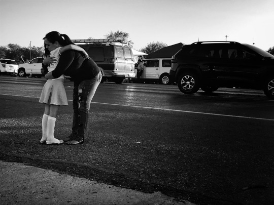
Meredith Cooper, from nearby San Antonio, comforts her 8-year-old daughter, Heather, across the street from the First Baptist Church in Sutherland Springs, Tex., the site of Sunday’s mass shooting. (Photo: Holly Bailey/Yahoo News)
Cooper said her daughter, who had heard about the attack on television, was upset and had wanted to visit the scene to lay flowers for the victims. Her school in San Antonio had been on lockdown earlier Monday, amid a heightened sense of threat. “You have kids her age trying to understand why,” Cooper said, as her daughter began to cry. “How do you explain this to a child when you can’t even understand it?”
#mass shooting#_revsp:Yahoo! News#_author:Holly Bailey#_lmsid:a077000000CFoGyAAL#sutherland springs#texas#_uuid:40e0edc0-8442-3f47-bff7-8ce0d40533b4
0 notes
Text
Days 47 to 50 - Borroloola
We set off for Lorella Springs, but it turned out to be a long hard day, driving on some of the worst roads we have travelled, certainly this trip. Some parts were fine, but there must have been a score or more creek crossings up to half a metre deep and dozens more dry dips and gullies that came upon us with little warning so driving was difficult, particularly in the stony areas where potholes were matched with rocks and washaways, giving way to loose sandy stretches, to challenge the driver – at least to keep him from nodding off.
Despite that, it was an interesting day. We were not confident that we had enough fuel to do the trips in and out to all the attractions en route and in the end, we decided not to drive the 50km in and out of Lorella Springs as well as some of the other side-trips we could have taken so headed straight through to Borroloola – a remote destination we have looked forward to for more than 5 years.
We did a couple of short excursions off the main road, but decided to come back into the area to explore them when we had more fuel on our return journey in a week or so. One such excursion was to Butterfly Springs, a lovely water-lily pool at the foot of a trickle of water running down some towering rocks. It is very pretty with lots of birds around and is apparently the only place in Limmen National Park where it is safe to swim. We didn’t go for a dip, but it was a nice little stopover only a few kilometres from the main track. We also called in at Maria Lagoon, but it turned out to be just a station homestead. There was another lagoon with heaps of water-lilies nearby, but all pretty inaccessible. While we were looking though, we had four beautiful healthy horses come to check us out, very frisky, maybe wild and afraid of these strange creatures in their territory, but lovely to watch. We had seen a perentie and a few wild donkeys earlier in the day too.
Late in the day we came across a flurry of diamond doves, the first we had seen this trip, although I had been expecting them for several thousand kilometres. We saw scores of them in a couple of kilometres and then almost none again for the next 100km. Another exciting sighting was a pair of bustards wandering across the road as we navigated a bend so we stopped and watched them for a while. They seemed as curious about us as we were about them and were in no hurry to wander further into the undergrowth.
For maybe 60-70km along this road, we had travelled beside a low ridge of hills, occasionally between two ridges, never more than 100 metres or so from the road. They were rarely more than about 20 metres high, but had a layer of hard rock at the top and a cascade of smaller eroded stones down the slopes below it. There was an area of reddish rock for a few kilometres in the middle, but most of it was white rock and the scree was almost always surrounded by green grass – like a green canvas with white rocks scattered across it. Quite unusual and almost pretty. We also traversed large areas of open woodland – or is it grassland? Looking out across it, there is a thin-ish layer of green (sometimes not so green in drier areas) with hundreds of stark white tree trunks distributed sparsely throughout, with enough to top it all with a thicker layer of green foliage, almost none of it more than 6-7 metres high. There seemed to be no middle storey across quite large distances and I found that landscape quite attractive too.
A disappointing aspect of the day was the speed at which the relatively few oncoming vehicles travelled. We always slow down (actually stop sometimes) and pull well off the road to give them as much room as possible, but many of them roar past at absurd speeds, trailing a wall of rocks behind them. As a consequence, we have several cracks across the driver's side of our windscreen and numerous paint chips. We will need to have the windscreen replaced, but that will probably have to wait until we get back to Katherine in a week or two.
The last hour into Borroloola was in the dark and a difficult drive, but fortunately, once we reached the Carpentaria Highway, it was sealed for the rest of the drive.
We set up camp in the Borroloola Caravan Park a little exhausted after a challenging, but very enjoyable day.
Next day, we had quite a few maintenance jobs to attend to – including rehanging the freezer door that had shaken loose on the previous day’s rough ride (fortunately it hadn’t fallen right off). Also had to tighten up the spare wheels and the roof-rack anchors that had become loose – I hope there are no other things at risk of separating from their moorings. We also had to do some cleaning. We are not neat freaks, but after so many hundred kilometres on dusty gravel roads, it was time for a few loads of washing and a bit of spit and polish on all the dusty surfaces in car and van. We also had to refuel and visit the supermarket and explored a little around suburban Borroloola (the other two streets) and the boat ramp on the proud MacArthur River – another quite substantial waterway that must be a raging torrent in the Wet. Our visit to the commercial centre of town was a bit confronting for me – almost exclusively black people and pretty dissolute from all appearances – not at all pleasant or welcoming.
We then drove the 60-odd km to the quaintly named Bing Bong Loading Terminal on the gulf of Carpentaria. The Terminal is all off limits to plebs like us, but is used for loading the zinc and lead ores mined in the area (seems like maybe 200km away). We were able to skirt the Terminal on a dirt road and went out to the mouth of Mule Creek where we saw and engaged in conversation with a small number of aboriginal men. They were butchering a green turtle and a dugong they had caught off-shore – all very traditional tucker done in the traditional way and it was fascinating talking to them. One guy in particular impressed me – educated, articulate and ready to share at least some aspects of indigenous life pretty freely. He improved my overall view of aboriginals – a radical counter to the observed lassitude in town. They told us about an aboriginal festival in Borroloola on Friday night and Saturday arvo/night so we have decided to stay here until at least Saturday. We will go to the Festival on Friday and then decide if we want to go on Saturday as well or head for Burketown across the border in Queensland.
After talking with the guys at Mule Creek, we found another rough track off the road and went in to what was basically the shore of the Gulf of Carpentaria.
There was quite a wide stretch of mud-flats before the water and we tried to identify some of the waders and shorebirds, but they were all just a little too far away.
Closer back towards Borroloola, we digressed to Batten Point and King Ash Bay near the mouth of the MacArthur River, but by then it was almost dark and every track we saw was sign-posted with ‘Life Members Only. Trespassers Prosecuted.’ so despite still being alive and members of quite a few things, we switched on the headlights and took a short-cut back to the caravan and dinner.
Wednesday, we set off a bit earlier (for us) to visit the Carabirini Conservation Reserve, about 50km back along the Carpentaria Highway. On the way down here, we had passed the Southern and Western Lost Cities on the assumption that we would visit them on our return trip, but there is a somewhat similar spectacle at Carabirini and we may elect to substitute that for another 100+km of rattles and dust when heading west. I used the word ‘spectacle’ because it is truly spectacular. It is like the Bungle Bungles, albeit on a smaller scale, but pretty extensive for all that, especially when walking through the towering stacks of ochre-coloured rocks – and there are LOTS of shades of ochre. There are canyons and pillars and sandstone formations of all shapes and sizes (mainly BIG), enough to leave your mouth agape for hours. I will add a few pics, but having looked at the product of my photography, I am very disappointed that I haven’t captured a fraction of the magnificence, grandeur and majesty of the area. We spent close to 3 hours there (although some of that was looking at birds) and came away trying to imagine the forces that transformed several hundred feet of underwater sediment into such mind-boggling structures, all of which had been tilted at crazy angles and eroded into the thousands of blocks and pancakes just for our amazement over thousands of millennia. There have been many times on this trip when I have been confronted with the immense age of the country and the titanic forces that worked over millions of years to produce what we have to enjoy today. It is not quite infinite, but trying to imagine the millions of human lifetimes that passed before the first humans evolved, with the natural forces of wind, water and warmth weathering the land (a lovely little lot of lyrical alliteration, eh?), is all a bit much for me to take in. (And I like the definition of infinity that you could travel for trillions of miles in any direction and still have exactly the same distance in front and behind you as if you had never moved.)
After our walk through this amazing area, we were due for lunch, so walked 100m from the carpark to a bird hide overlooking the Carabirini Waterhole. This was yet another beautiful freshwater lagoon, with thousands of water-lilies and hundreds of birds – both water-birds and bush-birds. Until the Sun intruded through the doorway, it was wonderfully cool in the hide and we spent a great hour or two admiring the scenery and identifying a dozen or more species of birds. It was a perfect interlude to complement our delightful walk through the sandstone spires of the ‘lost city’.
On the way back into town, we called in at another ‘Springs’ place, but it appeared to be a very run-down and unwelcoming aboriginal community so we took our leave without even stopping for a longer look.
On Thursday, we spent more than half the day doing a bit of cleaning and tidying, arranging our travel insurance for our trip next year, working on our photos and blogs and generally taking it easy under the air conditioner. We did go out for a couple of hours to explore a bit more locally and visited an aboriginal arts centre, an aboriginal Sea Ranger station and a local museum. All were interesting, but the museum was fascinating. Borroloola was touted as a major port in the late 1800s and has an unexpectedly colourful past. It was the centre of a couple of failed pastoral endeavours, several failed mining ventures (and some successful). Australia’s largest diamond at almost 105 carats, barely 3000 carats smaller than the world’s largest one, was found here and the current mining venture has produced many hundreds of thousands of tons of both zinc and lead! The museum records epic stories of heroic struggle and survival, downed airmen battling the elements and wildlife, one surviving 141 days alone in the bush before being saved – quite amazing sagas from relatively recent times. But earlier, it was a place exceedingly rich in mayhem, riddled with cattle and horse duffers, frequent bashings and murders, theft and pillage, a hideout for many of Australia’s worst criminals whilst on the lam – quite a terrifying place to be from about the 1870s to the early 1900s. I am delighted to note that despite the need to exercise a modicum of care, it is now a place close to being riddled with law and order.
0 notes
Last Seen Blogs

foxless
see pinned for connected accounts

espe95
Little dreamer

ku-roh
c a t b o y :3c

hearthunter89
Tlukot srdce🫀🩺

jewishcocktaster
𝗞𝗜𝗪𝗜!!!!!!!!!!!!!!!!!!!!!!!!!