#tygart valley river
Text
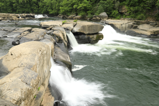
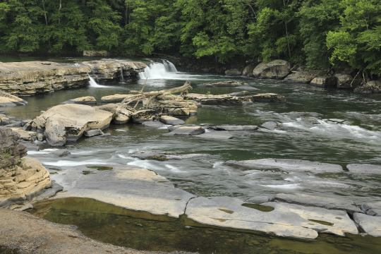

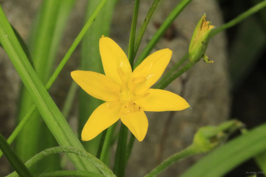


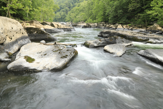
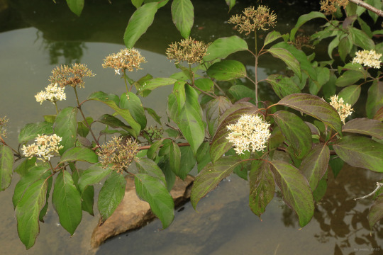
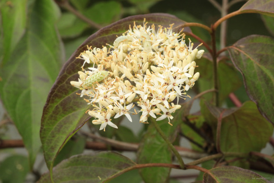
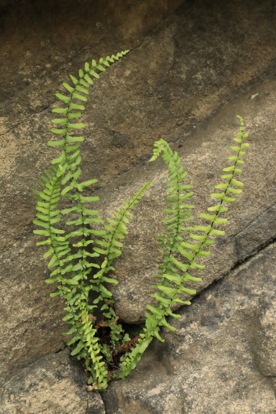

Where it narrows and plummets through a steep gorge at Valley Falls State Park, the Tygart Valley River has broken the Connoquenessing sandstone through which it passes into massive, jumbled slabs. In the margins of these wrecked pillars, where sediment and fine sand wash out, a great diversity of life has sprung up. The river is both destroyer and creator, more powerful and relentless than any god man has dreamed up.
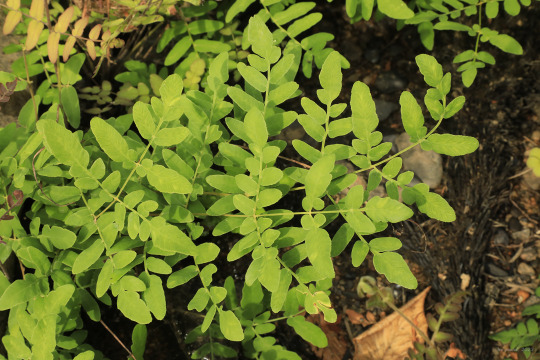
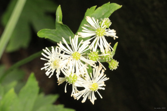
From top: royal fern (Osmunda regalis var. spectabilis), a water-loving beauty that clumps in the nooks between the boulders; the elegant tassel rue (Trauvetteria carolinensis), with its sharply-lobed, palmate leaves; yellow star grass (Hypoxis hirsuta), whose six-petaled flowers and delicate, grass-like leaves are quite attractive; American water willow (Justicia americana), whose creeping rhizomes allow the plant to form extensive colonies at the edges of streams and rivers; silky dogwood (Cornus amomum), a thicket-forming wetlands lover; and ebony spleenwort (Asplenium platyneuron), easily identified by its brown stem.
#appalachia#west virginia#vandalia#flora#wildflowers#valley falls state park#tygart valley river#connoquenessing sandstone#pottsville formation#rapids#waterfalls#royal fern#tassel rue#yellow star grass#common goldstar#american water willow#silky dogwood#ebony spleenwort#early summer
82 notes
·
View notes
Video
DGVR 7094 BLOC Elkins WV por Ian M. Hapsias
Por Flickr:
Durbin and Greenbrier's Belington local heads east into Elkins, WV over the Tygart Valley River. Unfortunately I got CF'ed on this one. Doesn't look too bad after running it through photoshop. Insult to injury was getting whacked by a wasp or hornet as I was walking back across the bridge. Whichever it was, sure as hell glad it only managed to get me once because man that HURT LIKE HELL! Lots of colorful words followed up that one.
11 notes
·
View notes
Photo

Photocopied December 1972 from original in collection of Mr. Roy Boliger, Grafton, WV, 1876. VIEW OF GRAFTON, WV AS VIEWED FROM THAYER. - Northwestern Virginia (B&O) Railroad, Grafton Machine Shop & Foundry, U.S. 119 East of Tygart Valley River, Grafton, Taylor County, WV
1 note
·
View note
Photo
April 15, 2017
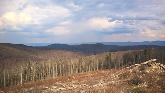
Taken from atop Rich Mt., looking southeast. Mill Ridge is in the mid-ground, rain showers are falling over the Tygart River Valley, Cheat Mountain is in the background.
2 notes
·
View notes
Text
Mountain Rail West Virginia
See on Scoop.it - itsyourbiz - Travel - Enjoy Life!
Mountain Rail Adventure excursions explore the more remote regions of the mountains where even automobiles cannot access! Trips range from day-long excursions into the Monongahela National Forest to shorter sight-seeing trips along the banks of the Greenbrier, Tygarts Valley and Shaver’s Fork rivers. From Cass, consider the two hour Whittaker trip in mid-May on historic cars pulled by the mighty steam-powered Shays, or an excursion to the top of West Virginia’s third highest peak – Bald Knob.
0 notes
Link
With some of the east coast's most beautiful and rugged scenery, West Virginia is filled with year-round outdoor adventure opportunities.
Its wild mountain country, densely-forested wilderness areas, and fast-running rivers are playgrounds for hiking, camping, caving, rock climbing, whitewater rafting, boating, and fishing. In the winter, ski resorts offer a range of snow sports. Active travelers will never run out of things to do here. While many tourists come to the state for these outdoor activities and scenic landscapes, West Virginia offers much more in the way of tourist attractions, from the historic sights of Harpers Ferry and the elegant Greenbrier and its legendary golf courses to some very unusual attractions, including a penitentiary to tour.
[toc]
1. Harpers Ferry
The Shenandoah River meets the Potomac River at this small West Virginia town, which was the site of abolitionist John Brown's raid on the United States arsenal in 1859, an event that hastened the onset of the Civil War.
Harpers Ferry National Historical Park has museums, historical exhibits, and programs, plus about 20 miles of hiking trails. You can explore the rocks where the rivers meet and walk up to St. Peter's Roman Catholic Church and the old cemetery on the hill behind it.
Also in Harpers Ferry is the Appalachian Trail Visitors Center, from which you can take a hike on the Appalachian Trail for views of the town and rivers. Local outfitters offer tubing excursions in the river.
2. New River Gorge National River
Contrary to its name, New River is one of the oldest rivers on the continent. When it flows into West Virginia, it cuts through the Appalachian Plateau, forming the New River Gorge and plenty of white water for pipes, rafting, and boating.
Other recreational opportunities revolve around it: hiking, walking, hunting, fishing, bird watching, camping, biking, and climbing. The most photographed attraction is the soaring New River Bridge, the longest steel span in the hemisphere and the nation's third tallest, 876 feet above the canyon floor.
The National Park Service maintains 70,000 acres of parklands along the river, and at Hawk's Nest State Park, you can ride an aerial tramway into the bottom of the New River Gorge, a prime spot for whitewater rafting.
South of New River Gorge National Park at Bluestone State Park there is hiking, fishing, camping and boating on the large lake behind the Bluestone dam.
3. Blackwater Falls State Park
Named for the dark waters of the Blackwater River, colored by tannic acid from fallen hemlock and red spruce needles, Blackwater Falls drops 60 feet over sandstone ledges before the river continues to rush through an eight-mile-long gorge. The steps and viewing platforms make the falls accessible year-round.
Besides, the famous places to visit in the park are Elakala Falls, which cascades down the canyon wall and can be reached by a short trail and Pendleton Falls, easily visible from a small path.
The view into the Blackwater Canyon from Lindy Point, one of the most beautiful places in West Virginia, is another park highlight, as is Pendleton Point Overlook, at the canyon's deepest point. The park has a boating lake, as well as swimming, fishing, and camping.
Address: 1584 Blackwater Lodge Road, Davis, West Virginia.
4. Whitewater Rafting
It's no secret that West Virginia is one of the best places to go whitewater rafting. Several rivers offer world-class rapids for experts, and others are well-suited to less experienced and learning rafters.
The most famous waters are in the Gauley River, between Summersville and Fayetteville, in the Gauley River National Recreation Area. Here, the 25-mile river flows at high speed through gorges and valleys, providing the thrill of a lifetime to experienced rafters; it's no wonder the Class V rapids are nicknamed the "Beast of the East."
Fall is the time to find the most challenging flow, but at any time it's a good idea to hire an experienced guide who knows the river and its quirks and can help you find the places that are best suited to your experience level. Although it's known for its Class V rapids the Gauley has some stretches of Class III that are suitable for intermediate levels.
For those with less experience, the Tygart River, Cheat River, and Potomac River are good options, as is the Upper New River, which has good stretches for beginners. Lower New River has Class IV rapids that offer runs past the New River Gorge Bridge.
5. Seneca Rocks and Monongahela National Forest
[caption id="attachment_703366" align="aligncenter" width="1024"] [/caption]
With elevations from about 1,000 feet to 4,863 feet above sea level, Monongahela National Forest offers the best views, wildlife and highest point in the state.
The variety of terrain and rainfall across its more than 900,000 acres gives it one of the most diverse forest ecosystems in the country, supporting more than 225 bird species; 75 species of trees; and 70 fish species, both game, and non-game.
About 100,000 acres of the park is designated as the Spruce Knob-Seneca Rocks National Recreation Area, offering some of the best traditional multi-pitch technical climbing on the east coast.
Seneca Rocks is a distinctive 250-foot-deep formation of white and gray quartzite that stands almost 900 feet above the North Fork River. Some routes are moderate, but experts are challenged by the exposed summit pinnacle.
Non-climbers can enjoy the Seneca Rocks Discovery Center and campgrounds at Seneca Shadows and Big Bend, along with thousands of acres of wildlands.
6. Snowshoe
This year-round resort is best known for its skiing, with three separate areas to choose from, all with 100 percent snowmaking. With an 800-foot vertical drop, Snowshoe Basin's 38 trails cover all experience levels, served by seven lifts, including a high-speed detachable quad.
Of Silver Creek's 18 trails, 12 are open for night skiing. The Western Territory Area's steep, rugged terrain has 1,500 feet of vertical drop, the most advanced terrain in the region. Steeps on Cupp Run, designed by legendary Olympian Jean-Claude Killy, and Shay's Revenge reach 52 percent pitch.
In other seasons, activities include mountain biking, scenic chairlift rides, geocaching, horseback riding, Segway tours, ziplining, trampolining, climbing, pedal boats, paddle boarding, canoeing, hiking, fishing, and golf at the Raven Golf Club. Not far away, in Greenbank, is the National Radio Astronomy Observatory.
Address: 10 Snowshoe Drive, Snowshoe, West Virginia
7. The Greenbrier
The Greenbrier has earned its designation as a National Historic Landmark several times over. Located at White Sulphur Springs, which has been in use as a natural spa since the 1700s, the grand hotel has hosted 26 presidents, foreign dignitaries, and royalty, including Prince Rainier and Princess Grace of Monaco and the Duke and Duchess of Windsor.
But however grand and luxurious it is as a resort, it has played other historic roles, too. Early in World War II, it was used as a detention center for German and Japanese diplomats who were in the United States when war was declared.
Later in the war, it was commandeered by the U.S. Army to use as a hospital, where nearly 25,000 patients were treated. During the Cold War, an underground shelter was built to house the entire U.S. Congress in case of a nuclear attack.
This shelter, given the code name "Project Greek Island," was decommissioned in 1992 and is open to the public for tours, as is the Presidents' Cottage Museum, with exhibits about presidential visits and the history of the resort.
More than 50 different activities are available in the resort and the 5,100-acre Greenbrier State Forest. Along with horseback riding, indoor and outdoor tennis courts, adventure courses, and a 40,000 square-foot spa, the resort has multiple golf courses (even an indoor one for winter) and an outstanding golf history is a venue for many championships.
Greenbrier State Forest offers cabins and campsites, swimming, fishing, bike trails, and hiking — the 78-mile-long Greenbrier River Trail is a multi-purpose rail-trail that is also used for cross-country skiing in the winter. A getaway in one of the centuries-old Legacy Cottages is one of the most romantic things to do in West Virginia.
Address: 300 W. Main Street, White Sulphur Springs, West Virginia
8. Seneca Caverns
The formation of the Seneca Caverns dates back to 460 million years before the cave's limestone beds first formed. The native Seneca are believed to have used caves for shelter starting in the early 1400s.
The cave was later found by a local farmer, Laven Teter while looking for water for his cattle. , and the largest chamber, up to 60 feet tall, was named Teter Hall in his memory.
You can visit one-hour guided tours down to 165 feet below the entrance. The walkways are well lit, and cement steps with handrails help visitors navigate deeper into caves. The separate Stratosphere Cave is on the same property.
Address: 3328 Germany Valley Road, Riverton, West Virginia.
9. West Virginia Penitentiary
One of the most unlikely places to visit in any state, the West Virginia Penitentiary welcomes guests from April through November to tour the grim prison that sometimes held more than 1,000 prisoners at a time.
The Gothic fortress was banned from opening in 1876 and the last prisoner left in 1995. Between those dates, it was the scene of fires, escapes, prison riots, and almost 100 executions.
Visitors can tour the building and its claustrophobia-inducing five-foot by seven-foot cells during the day, or explore the reportedly haunted location at night. A penitentiary is a popular place for paranormal researchers looking for evidence of spectral phenomena.
Address: 818 Jefferson Ave, Moundsville, West Virginia
10. Trans-Allegheny Lunatic Asylum
A unique tourist attraction like the West Virginia Court, Trans-Allegheny Lunatic Asylum is a landmark in the history of treatment for people with mental illness. Built between 1858 and 1881, the refugee is the largest hand-cut stone building in the hemisphere, and in the world, it is only exceeded by the Kremlin in Moscow.
Architect Richard Andrew designed this landmark. He arranged long rambling wings in a staggered formation so that each connected structure received as much therapeutic sunlight and fresh air. possible.
Tours highlight a number of historical themes, including architecture, Civil War raids, treatment of the mentally ill, even the facility's agricultural history and place in the local community. Like the West Virginia Court, the refugee camp is also a research site for paranormal investigators.
More ideals for you: Top 10 things to do in Rochester NY
From : https://wikitopx.com/travel/top-10-things-to-do-in-west-virginia-2-703358.html
0 notes
Text
21 Reasons Why People Love School Landscape Painting | school landscape painting
21 Reasons Why People Love School Landscape Painting | school landscape painting – school landscape painting
| Allowed to my blog, on this period I’ll demonstrate regarding keyword. And now, this is actually the very first photograph:
Continental School Landscape Painting – school landscape painting | school landscape painting
Think about photograph earlier mentioned? is actually in which wonderful???. if you think so, I’l m demonstrate some picture again underneath:
So, if you would like have all of these great pics about (21 Reasons Why People Love School Landscape Painting | school landscape painting), simply click save button to save these graphics in your pc. They’re ready for download, if you’d rather and wish to take it, simply click save logo on the post, and it will be instantly saved to your laptop computer.} At last if you like to grab unique and the recent photo related with (21 Reasons Why People Love School Landscape Painting | school landscape painting), please follow us on google plus or bookmark this blog, we attempt our best to present you daily update with all new and fresh photos. Hope you love staying here. For most up-dates and recent information about (21 Reasons Why People Love School Landscape Painting | school landscape painting) pics, please kindly follow us on tweets, path, Instagram and google plus, or you mark this page on book mark section, We try to provide you with up-date regularly with fresh and new images, enjoy your searching, and find the ideal for you.
Here you are at our site, articleabove (21 Reasons Why People Love School Landscape Painting | school landscape painting) published . Today we’re pleased to declare we have found an incrediblyinteresting nicheto be pointed out, namely (21 Reasons Why People Love School Landscape Painting | school landscape painting) Most people attempting to find info about(21 Reasons Why People Love School Landscape Painting | school landscape painting) and certainly one of these is you, is not it?
Home [http://bit.ly/2snTfgc] – school landscape painting | school landscape painting
Hudson River School – Wikipedia – school landscape painting | school landscape painting
Tygarts Valley High School Class of 1964: DAY 78 … – school landscape painting | school landscape painting
Art II: Landscape painting – Fairhaven High School Visual Arts – school landscape painting | school landscape painting
British School, 21thCentury | BRITISH SCHOOL LANDSCAPE PAINTING … – school landscape painting | school landscape painting
Barbizon School. Landscape, painting – Expertissim – school landscape painting | school landscape painting
21 Amazing Color Paintings of Asher Brown Durand – American Hudson … – school landscape painting | school landscape painting
Beauty of American landscape immortalized by Hudson River … – school landscape painting | school landscape painting
Asher Brown Durand The Beeches oil painting image … – school landscape painting | school landscape painting
Across to the Island – in explore – school landscape painting | school landscape painting
The Hudson River School via Cincinnati | Visual Art … – school landscape painting | school landscape painting
21TH CENTURY BRITISH SCHOOL LANDSCAPE ANTIQUE OIL PAINTING SIGNED … – school landscape painting | school landscape painting
21th Century Hudson River School Landscape Oil Painting by Thomas … – school landscape painting | school landscape painting
American Hudson River School 19th century luminous … – school landscape painting | school landscape painting
MOUNTAIN LANDSCAPE WITH A RIVER – Auktionshaus Lempertz – school landscape painting | school landscape painting
Maple Hill High School Art: Drawing and Painting Acrylic Landscape … – school landscape painting | school landscape painting
American Tonalism | ART | Pinterest | Landscape paintings … – school landscape painting | school landscape painting
158 best images about Jerry Yarnell Paintings on Pinterest … – school landscape painting | school landscape painting
East meets West: The Hudson River School at LACMA | Apollo Magazine – school landscape painting | school landscape painting
Jane Bloodgood-Abrams – Above (Luminist Style Hudson River School … – school landscape painting | school landscape painting
from WordPress https://landscapeusa.club/21-reasons-why-people-love-school-landscape-painting-school-landscape-painting/
0 notes
Text
A Tourist Guide to West Virginia
Stand Out – Be Seen – Be On Google Page 1 Before You Pay For Services – CLICK HERE! We call it RBI Marketing. You have heard of ROI which is Return On Investment and this is RBI which means Return BEFORE Investment! Let’s get the ball rolling and you will pay us for our services AFTER you see your site ranked on Google page 1 for your chosen keywords!.CLICK HERE!
***********
We are always on the lookout to hire quality, professional independent representatives for our local business pay per result search engine optimization services. Just use the form on the home page to contact us!
************
1. INTRODUCTION
West Virginia, endlessly covered with forests and known as the “Mountain State,” offers breathtaking scenery, natural resource-related sights, and year-round, outdoor activities.
Once rich in coal and timber, it was shaped by the mines and logging railroads which extracted them, but when decades of removal began to deplete these commodities, their rolling, green-carpeted mountains yielded secondary byproducts-namely, hiking, biking, fishing, rafting, climbing, and hunting to tourists and sports enthusiasts alike. Its New River Gorge, which offers many similar activities, is equally beautiful with its rugged banks and azure surfaces, while the principle city of Charleston, revitalized during the 1970s and 1980s, now features museums, art, shopping malls, restaurants, and world-class performance venues.
2. CHARLESTON
Located on the Kanawha River, and sporting an easily negotiable street grid system, it is subdivided into the Capitol Complex and the downtown area with the East End Historic District linking the two.
From the former, which is the heart of state government, juts the ubiquitously visible, gold-domed Capitol Building itself. Constructed of buff Indiana limestone and 4,640 tons of steel, which themselves required the temporary laying of a spur rail line to transport them, the building had been laid in three stages during an eight-year period: 1924 to 1925 for the west wing, 1926 to 1927 for the east wing, and 1930 to 1932 for the connecting rotunda. It was officially dedicated by Governor William G. Conley on June 20, 1932, on the occasion of West Virginia’s 69th birthday as a state.
Its gold dome, which extends five feet higher than that of the Capitol in Washington, is gilded in 23 ½-karat gold leaf, applied between 1988 and 1991 as tiny squares to cover the otherwise copper and lead surface.
Two-thirds of its interior, which encompasses 535,000 square feet subdivided into 333 rooms, is comprised of Italian travertine, imperial derby, and Tennessee marble, and the chandelier in the rotunda, its center piece, is made of 10,180 pieces of Czechoslovakian crystal illuminated by 96 light bulbs. Weighing 4,000 pounds, it hangs from a 54-foot brass and bronze chain.
Across from the State Capitol, but still within the complex, is the West Virginia Cultural Center. Opened in 1976 and operated by the West Virginia Division of Culture and History, it was created to showcase the state’s artistic, cultural, and historical heritage, and houses the West Virginia State Museum, the archives and history library, a gift shop, and a venue for cultural events, performances, and related programs.
The former, a collection of items which represents the state’s land, people, and culture, is subdivided into 24 significant scenes covering five periods: Prehistory (3 million years BC to 1650 AD), Frontier (1754-1860), the Civil War and the 35th State (1861 to 1899), Industrialization (1900 to 1945), and Change and Tradition (1954 to the 21st century). The 24 representations themselves trace the state’s evolution and include such periods as “Coal Forest,” “River Plains,” “Wilderness,” “The Fort,” “Harper’s Ferry,” “Building the Rails,” “Coal Mine,” “Main Street, West Virginia,” and “New River Gorge.”
Thirteen monuments, memorials, and statues honoring West Virginians for their contributions to the state and the nation grace the Capitol Complex’s landscaped grounds.
Culture can also be experienced at the Clay Center for the Arts and Sciences, a modern, 240,000-square-foot, three-level complex which opened on July 12, 2003 and represents one of the most ambitious economic, cultural, and educational projects in West Virginia’s history. Offering sciences, visual arts, and performing arts under a single roof, the center houses the dual-level Avampato Discovery Museum, an interactive, youth-oriented experience with sections such as Health Royale, KidSpace, Earth City, and Gizmo Factory. A 9,000-square-foot Art Gallery, located on the second floor, features both temporary and permanent exhibits, the latter emphasizing 19th and 20th century art by names such as Andy Warhol, Stuart Davis, Alexander Calder, Frank Stella, Vida Frey, and Albert Paley. The ElectricSky Theater, a 61-foot domed planetarium, offers daily astronomy shows and wide screen presentations. Live performances are staged in two locations: the 1,883-seat Maier Foundation Performance Hall, which is home to the West Virginia Symphony Orchestra, but otherwise offers a variety of performance types, from comedy to popular singers, bands, repertory, and Broadway plays, and the 200-seat Walker Theater, which features plays and dances with cabaret-style seating for the Woody Hawley singer-songwriter program. The Douglas V. Reynolds Intermezzo Café and three classrooms are located on the lower level.
Shopping can be done at two major venues. The Charleston Town Center Mall, located adjacent to the Town Center Marriott and Embassy Suites Hotel, and near the Civic Center, is a one million square foot, tri-level complex with more than 130 stores, three anchor department stores, six full-service restaurants, and a food court with ten additional fast food venues, and is accessed through three convenient parking garages. Sporting a three-story atrium and fountain, the upscale, Kanawha Valley complex was the largest urban shopping center east of the Mississippi River when it opened in 1983.
The Capitol Market, located on Capitol and Sixth Streets in the restored and converted, 1800s Kanawha and Michigan Railroad depot, is subdivided into both in- and outdoor markets, the latter of which can only be used by bona fide farmers and receives daily, fresh, seasonal deliveries, usually consisting of flowers, shrubs, and trees in the spring; fruits and vegetables in the summer; pumpkins, gourds, and cornstalks in the fall; and Christmas trees, wreaths, and garlands in the winter. The indoor market sells seafood, cheeses, and wines, and offers several small food stands and a full-service Italian restaurant.
An evening can be spent at the TriState Racetrack and Gaming Center. Located a 15-minute drive from Charleston in Cross Lanes, the venue offers 90,000 square feet of gaming entertainment, inclusive of more than 1,300 slot machines, live racing, a poker room, blackjack, roulette, and craps, and four restaurants: the French Quarter Restaurant and Bar, the First Turn Restaurant, the Café Orleans, and Crescent City.
3. POTOMAC HIGHLANDS
The Potomac Highlands, located in the eastern portion of the state on the Allegheny Plateau, is a tapestry of diverse geographic regions and covers eight counties. Alternatively designated “Mountain Highlands,” it had been formed some 250 million years ago when the North American and African continental collision had produced a single, uplifted mass. Subjected to millennia of wind- and water-caused erosion, it resulted in successive valleys and parallel ridges, and today the area encompasses two national forests: Canaan Valley, the highest east of the Mississippi River, and Spruce Knob, at 4,861 feet, West Virginia’s highest point. Its green-covered mountains yielded abundant timber, the logging railroads necessary to harness it, two premier ski resorts, and a myriad of outdoor sports and activities.
The Potomac Highlands can be subdivided into the Tygart Valley, Seneca Rocks, Canaan Valley, and Big Mountain Country.
A. Tygart Valley
The town of Elkins, located in the Tygart Valley, is the transportation, shopping, and social center of the east central Appalachian Mountains and serves as a base for Potomac Highland excursions.
Established in 1890 by Senators Henry Gassaway Davis and Stephen. B. Elkins, his son-in-law and business partner, it originated as a shipping hub for their coal, timber, and railroad empire, the latter the result of their self-financed construction of the West Virginia Central Railroad, whose track stretched between Cumberland, Maryland, and Elkins, and served as the threshold to some of the world’s richest timber and mineral resources.
The town, serving the needs of the coal miners, loggers, and railroad workers, sprouted central maintenance shops and steadily expanded, peaking in 1920, before commencing a resource depletion-caused decline, until the last train, carrying coal and timber products to the rest of the country, departed the depot in 1959.
The tracks lay barren and unused for almost half a century until 2007, when the newly-established Durbin and Greenbrier Valley Railroad again resurrected them-and the town-transporting the first tourists for scenic-ride purposes and resparking a slow growth cycle with a subsequently built restaurant and live theater in its historic Elkins Railyard and additional hotels nearby. Consistently ranked as one of the country’s best small art towns, it is once again the service hub of the Mountain Highlands, reverting to its original purpose of providing hotel, restaurant, shop, and entertainment services, but now to a new group-tourists.
The railroad remains its focus. The Durbin and Greenbrier Valley Railroad offers three departures from the Elkins depot. The first of these, the “New Tygart Flyer,” is a four-hour, 46-mile round-trip run which plunges through the Cheat Mountain Tunnel, passes the towns of Bowdon and Bemis, parallels the Shavers Fork of the Cheat River, and stops at the horseshoe-shaped High Falls of Cheat, during which time it serves an en route, buffet luncheon. Upgraded table service is available in 1922-ear deluxe Pullman Palace cars for a slightly higher price.
The “Cheat Mountain Salamander” is a nine-hour, 128-mile round-trip to Spruce, and includes a buffet lunch and dinner, while the “Mountain Express Dinner Train” mimics the New Tygart Flyer’s route, but features a four-course meal in a formally set dining car.
The Railyard Restaurant, sandwiched between the Elkins depot and the American Mountain Theater, provides all on board meals. Emulating the depot itself with its exterior brick construction, the $2.5 million, 220-seat restaurant, leased to the Durbin and Greenbrier Valley Railroad, serves family-style cuisine on its main level and upscale dinners in its second-floor Vista Dome Dining Room, its menus inspired by railroad car fare from the 1920s to the 1940s. It toted the opening slogan of, “Take the track to the place with exceptional taste.”
The Durbin and Greenbrier Valley Railroad’s Rails and Trails Gift Shop is located on its main level.
Continuing the historic, red brick exterior, the adjacent American Mountain Theater, founded in 2003 by Elkins native and RCA recording artist, Susie Heckel, traces its origins to a variety show performed for tourists at a different location. But increasing demand merited the November, 2006, ground-braking for a $1.7 million, 12,784-square-foot, 525-seat structure with aid from her sister, Beverly Sexton, and her husband, Kenny, who owned the Ozark Mountain Hoe-Down Theater in Eureka Springs, Arkansas.
Opening the following July, the theater offered family-oriented, Branson-style entertainment performed by a nine-member cast, with Kenny Sexton serving as its president and producer and Beverly writing the score. Two-hour evening shows include comedy, impressions, and country, gospel, bluegrass, and pop music.
Davis and Elkins College, located only a few blocks from the Historic Railyard, shares the same founders as the town of Elkins itself-namely, Senators Henry Gassaway Davis and Stephen B. Elkins. Established in 1901 when they donated land and funding to create a college associated with the Presbyterian Church, it was originally located south of town. Its Board of Trustees first met the following year and classes were first held on September 21, 1904.
Today, the coeducational, liberal arts college, located on a 170-acre hilled, wooded campus with views of the Appalachian Mountains, is comprised of 22 new and historic buildings in two sections-the north, which stretches to the athletic fields and the front campus, which is located on a ridge overlooking Elkins. Thirty associate and baccalaureate arts, sciences, pre-professional, and professional degree programs are offered to a 700-student base.
One of its historic buildings is Graceland Inn. Designed by the Baltimore architectural firm of Baldwin and Pennington, the castle-like, Queen Anne-style mansion, originally located on a 360-acre farm, was completed in 1893. Initially called “Mingo Moor,” and intermittently “Mingo Hall” after the area south of Elkins, the estate served as the summer residence of Senator Davis, who regularly transported a train of invited friends and associates during July and August so that they could escape the Washington heat and enjoy Elkins’ higher-elevation, cooler temperatures.
The estate was ultimately renamed “Graceland” after Davis’ youngest daughter, Grace. Following his wife’s death in 1902, he continued to conduct business from offices inside it, while Grace herself resided there during the summer months with her family.
The estate was finally ceded to her own children, Ellen Bruce Lee and John A. Kennedy, its last two owners.
Acquired by the West Virginia Presbyterian Education Fund in 1941, it was used as a male residence hall by the college until 1970, whereafter it was closed. Restored during the mid-1990s, it subsequently reopened as an historic country inn and as a dynamic learning lab for hospitality students.
Overlooking the town of Elkins, on the Davis and Elkins College campus, Graceland Inn, listed on the National Register of Historic Places, features a two-story great hall richly decorated with hardwoods, such as quartered oak, bird’s eye maple, cherry, and walnut, a grand staircase, a parlor, a library, and its original stained glass windows. The Mingo Room Restaurant, reflecting the mansion’s initial designation and open to the public, is subdivided into four small rooms lined with red oak and fireplaces and an outdoor verandah, and eleven guest rooms, located on the second and third floors and named after prominent family members, contain antiques, canopy beds, armoires, marble bathrooms, and claw foot tubs.
Graceland Inn, the David and Elkins College, the town of Elkins itself, the historic depot and railyard, their tracks, and the Appalachian Mountain’s coal and timber resources are all inextricably tied to the town’s past–and its future.
B. Seneca Rocks
“Seneca Rocks” designates both a region of the Potomac Highlands and the outcroppings after which that region is named.
Resembling a razor back, or shark’s fin, and located at the confluence of the Seneca Creek and the North Fork South Branch Potomac River, the 250-foot-thick, 900-foot-high Seneca Rocks, accessible by West Virginia Route 28, were formed 400 million years ago during the Silurian Period in an extensive sand shoal at the edge of the ancient Iapetus Ocean. As the seas decreased in size, the rock uplifted and folded, erosion ultimately wearing away its upper surface and leaving the arching folds and craggy profile they exhibit today.
Made of white and gray tuscarora quartzite, the formation features both a north and south peak, with a notch separating the two.
The current Seneca Rocks Discovery Center, which replaced the original visitor’s center, features relief models of the area, films, interpretive programs, and a bookshop.
A path leads to the Sites Homestead, part of the center. Constructed in 1839 by William Sites as a single-room log cabin below Seneca Rocks Ridge, it is typical of then-current Appalachian homes whose German Blockbau-style featured square logs and v-notched corner joints spread apart by stone and clay chinks.
In the late-1860s, one of Sites’ sons expanded the homestead, adding a second floor, and, after use as a hay barn, the Forest Service purchased it in 1969, restoring it during the 1980s. In 1993, it was added to the National Register of Historic Places.
The greater Spruce Knob-Seneca Rocks National Recreation Area, offering significant outdoor sports opportunities, contains a key portion of the Chesapeake Bay watershed, whose mountains and forests collect water which then flows into the Potomac River and the bay itself. Acting as a cleansing and filtering mechanism, its headwater forests purify the water before it reaches the streams. Spruce Knob is both the highest point in the Chesapeake Watershed and the entire state of West Virginia.
Aside from facilitating water, the area has provided sustenance to humans, who first lived in Native American villages within its mountains, and then created farming settlements and logging camps, extracting its resources and supporting life for some 13,000 years. Today, it is home to 15 million people.
The Spruce Knob-Seneca Rocks National Recreation Area itself is part of the much larger Monongahela National Forest. Established in 1920 with an initial 7,200 acres, the present 910,155-acre forest contains the headwaters of the Monongahela, Potomac, Greenbrier, Elk, Tygart, and Gauley Rivers; five federally-designated “wildernesses”-Dolly Sods, Outer Creek, Laurel Fork North, Laurel Fork South, and Cranberry-whose very remote and primitive areas only offer lower-standard trail markings; and four lakes.
A Mecca for outdoor sports enthusiasts, the national forest features 169 hiking, biking, and horseback riding trails which cover more than 800 miles, 576 miles of trout streams, 129 miles of warm-water fishing, 23 campgrounds, 17 picnic areas, and wildlife viewing of black bear, wild turkey, white-tailed deer, gray fox, rabbits, snowshoe hare, grouse, and woodcock.
C. Canaan Valley
Blanketed with bigtooth aspen, balsam fir, and spruce, Canaan Valley, stretching 14 miles, is the highest such valley east of the Mississippi River, its namesake mountain separating it from the Blackwater River and creating a deep, narrow canyon in the Allegheny Plateau.
The pristinely beautiful area encompasses two state parks-Canaan Valley Resort and Black Water Falls State Parks; two ski areas-again Canaan Valley Resort and Timberline Four Seasons Resort; and the nation’s 500th wildlife refuge.
Natural sports abound: hiking, horseback riding, fishing, golfing, swimming, rafting, and interpretive nature walking during the summer, and skiing, snowboarding, and tubing during the winter.
Nucleus of most of this is 6,000-acre Canaan Valley Resort State Park, which encompasses 18 miles of trails, wetlands, open meadows, northern hardwood forests, wildlife, 200 species of birds, and 600 types of wildflowers.
Canaan Valley Resort, located within the park, offers 250 modern guest rooms, 23 two-, three-, and four-bedroom mountain cabins with fireplaces and full kitchens, 34 paved, wooded campsites with full hook-ups, and six lounges and restaurants, including the Hickory Dining Room in the main lodge.
Its 4,280-foot mountain, whose longest run is 1.25 miles and whose vertical drop is 850 feet, features one quad and two triple lifts, and 11 trails for night skiing. Its winter activities, like those of the extended Canaan Valley, include skiing, snowboarding, airboarding, tubing, snowshoeing, and ice skating, while summer programs include scenic chairlift rides, guided walks, golf, tennis, and hiking.
D. Big Mountain Country
Big Mountain County, location of West Virginia’s second-highest peak, serves as the birthplace of eight rivers-the Greenbier, Gauley, Cheat, Cherry, Elk, Williams, Cranberry, and Tygart-while its Seneca State Forest, which borders the former in Pocahontas County, is the state’s oldest. An interesting array of sights include steam-powered logging railroads, astronomical observatories, preserved towns, a premier ski resort, and their associated assortment of outdoor sports and activities.
The Durbin and Greenbier Valley Railroad’s fourth excursion train, the “Durbin Rocket,” departs from the town of Durbin itself, located some 40 miles from Elkins.
Powered by a 55-ton steam engine built for the Moore-Keppel Lumber Company in nearby Randolph County, and one of only three remaining geared Climax logging locomotives, the train makes a two-hour, 11-mile round-trip run along the Greenbier River and through the Monongahela National Forest as far as Piney Island, where the rental “castaway caboose” is disconnected and pushed onto a very short spur track for a one or more night stay.
The ultra-modern, high-tech National Radio Astronomy Observatory, located a short distance away in Green Bank, offers an opportunity to learn about radio wave astronomy.
Designing, building, and operating the world’s most advanced and sophisticated radio telescopes, the observatory produces images of celestial bodies, such as planets, stars, and galaxies, millions of light-years away by recording their radio omission quantities.
The Green Bank Science Center, nucleus of this experience, features a museum which introduces the science of radio astronomy, radio waves, telescope operation, and what is being learned through them about the universe; the Galaxy Gift Shop; the Starlight Café; and the departure point for the escorted bus tour of the facility, prior to which an introductory film and lecture are presented in the theater.
The tour’s highlight is the Robert C. Byrd Green Bank Telescope (GBT), designed when the previous 300-foot device collapsed in 1988 and Congress was forced to appropriate emergency funds to design it.
Dedicated on August 25, 2000, after a nine-year development period, it is 485 feet tall, is comprised of 2,004 panels, has a 100-by-110 meter diameter, a 2.3 acre surface area, and weighs 17 million pounds. The world’s largest, fully maneuverable telescope with a computer-controlled reflecting surface, it is functionally independent of the sun, permitting 24-hour-per-day operation, and receives wavelengths which vary between 1/8th of an inch to nine feet.
Initially employed in conjunction with the Arecibo Observatory to produce images of Venus, it later detected three new pulsars (spinning neutron stars) in the Messier 62 region.
A 15-minute drive from the National Radio Astronomy Observatory is another significant sight, Cass Scenic Railroad State Park.
Tracing its origins to 1899 when John G. Luke acquired more than 67,000 acres of red spruce in an area which ultimately developed into the town of Cass, it became the headquarters of the West Virginia Pulp and Paper Company. The town, supporting the workforce needed to convert the raw resources into finished products, sprouted shops, services, houses, a sawmill, tracks, and a railroad to haul the timber.
Instrumental to the operation had been the Shay, or similarly-designed Climax and Heisler steam locomotives, whose direct gearing delivered positive control and more even power, allowing them to ply often temporarily-laid tracks, steep grades, and hairpin turns, all the while pulling heavy, freshly-felled timber loads. The Western Maryland #6, at 162 tons, was the last, and heaviest, Shay locomotive ever built. The railroad inaugurated its first service in 1901.
During two 11-hour, six-day-per-week shifts, the town’s mill was able to cut more than 125,000 board feet of lumber per shift and dry 360,000 per run with its 11 miles of steam pipes, adding up to 1.5 million board feet cut per week and 35 million per year. After 40 years of milling at Cass and Spruce, more than two billion board feet of lumber and paper had been produced.
Operating until 1943, the West Virginia Pulp and Paper Company sold the enterprise to the Mower Lumber Company, which maintained it for another 17 years, at which time it was closed and purchased by the state of West Virginia, in 1961.
The railroad and the town of Cass, which remain virtually unchanged, are listed on the National Register of Historic Places.
Aside from the historic buildings, there are several other attractions. Connected to the large Cass Company Store is the railroad-themed Last Run Restaurant. Turn-of-the-century logging can be gleaned at the Cass Historical Museum. The Shay Railroad Shop, having once housed coal bins, offers additional books and crafts for sale. The metal, Cass Showcase building above it, having stored hay to feed horse teams, features an introductory film and an HO-scale train and town layout reflecting their 1930s appearance.
Escorted walking tours of Cass, usually conducted in the afternoon after the trains have returned from their daily excursions, offer insight into what it had been like to live and work in a turn-of-the-century company town, while the Locomotive Repair Shop tour includes visits to the Mountain State Railroad and Logging Historical Association’s shop, the sawmill area, and a look at Shay and Climax locomotive maintenance and repair.
An excursion on the Cass Scenic Railroad itself, which commenced tourist rides in 1963 and is therefore the longest-running scenic rail journey in the country, is a living history experience. Pulled by one of the original Shay or Climax steam locomotives, the train accommodates passengers in equally authentic logging cars which have been converted to coaches with wooden, bench-like seats and roofs, while a single enclosed car, offering reserved seating, sports booth-like accommodation and is designated “Leatherbark Creek.”
All trains depart from Cass’s reconstructed depot, at a 2,456-foot elevation, climbing Leatherneck Run, negotiating 11-percent grades, maneuvering and reversing through a lower and upper switchback, and arriving at Whittaker Station, which features a snack stand, views of the eastern West Virginia mountains, and a reconstructed, 1946 logging camp. The eight-mile round-trip back to Cass requires two hours.
A four-and-a-half hour, 22-mile round-trip continues up Back Allegheny Mountain, passing Old Spruce and the Oats Creek Water Tank, and plying track laid by the Mower Lumber company, before reaching 4,842-foot Bald Knob, West Virginia’s third-highest peak.
Limited runs are also offered to Spruce, an abandoned logging town on the Shavers Fork of the Cheat River. This train also transits Whittaker Station.
Although not affiliated with the Cass Scenic Railroad, the Boyer Station Restaurant, located six miles from Green Bank on Route 28, offers inexpensive, home-cooked, country-style meals amidst railroad décor with wooden, rail depot-reminiscent tables and benches, train and logging memorabilia, and large-scale, track-mounted model railroads. It is part of a 20-room motel and campground complex.
Winter sports account for a significant portion of the Big Mountain Country’s offerings. Ten miles from Cass Scenic Railroad State Park is Snowshoe Mountain.
Located in the bowl-shaped convergence of Cheat and Back Allegheny Mountain at the head of the Shavers Fork of the Cheat River, the area, striped of trees by logging between 1905 and 1960, had been discovered by Thomas Brigham, a North Carolina dentist, who had previously opened the Beech Mountain and Sugar Mountain Ski Resorts.
Reflecting European style, Snowshoe Village is located on the mountain’s summit and offers 1,400 hotel and condominium rooms, restaurants, shops, services, and entertainment. The 244-acre resort, which combines the Snowshoe and Silver Creek areas, has a 3,348-foot base; a 4,848-foot summit, making it the highest such ski resort in the mid-Atlantic and southeast; 14 chairlifts; 60 runs, of which the longest is 1.5 miles; and 1,500-foot vertical drops at Cupp Run and Shay’s Revenge. Average snowfall is 180 inches. Spring, summer, and fall activities include golf, boating, bicycling, climbing, hiking, horseback riding, canoeing, kayaking, skating, and swimming.
The extended area’s Seneca State Forest, named after the Native Americans who had once roamed the land, borders the Greenbier River in Pocahontas County and contains 23 miles of forest, 11,684 acres of woodlands, a four-acre lake for boating and trout, largemouth bass, and bluegill fishing, hiking tails, pioneer cabins, and rustic campsites.
4. NEW RIVER-GREENBRIER VALLEY
The New River-Greenbrier Valley region of West Virginia is topographically diverse and ruggedly beautiful.
Split by the Gauley River, its northern section is comprised of a rugged plateau in which is nestled the calm, azure Summersville Lake, while mountainous ridgelines, affording extensive interior coal mining, are characteristic of its central region. Horse and cattle grazing is prevalent on the flat farm expanses which intersperse the eastern edge’s lush, green mountain plateau, divided by the Greenbrier River, the largest, untamed water channel in the eastern United States, which flows through it. Its southern region is a jigsaw puzzle of omni-directional ridgelines and very narrow valleys.
New and Bluestone River-formed gorges provide a wealth of rock climbing, canoeing, kayaking, and white water rafting opportunities in this region of the state.
The area’s most prominent, and beautiful, topographical feature is the New River Gorge National River. Flowing from below Bluestone Dam, near Hinton, to the north of the US Highway 19 bridge near Fayetteville, it dissects all the physiographic provinces of the Appalachian Mountains. A rugged, white water river, and among the oldest in North America, it flows northward through steep canyons and geological formations. Approximately 1,000 feet separate its bottom from its adjacent plateau. On July 30, 1998, it was named an American Heritage River, one of 14 waterways so designated.
Its related park encompasses 70,000 acres.
Signature of the New River Gorge National Park is its New River Gorge Bridge. Completed on October 22, 1977 at a $37 million cost, the dual-hinged, steel arch bridge is 3,030 feet long, 69.3 feet wide, and has an 876-foot clearance. Carrying the four lanes of US Route 19, it was then the world’s longest, and is currently the highest vehicular bridge in the Americas and the second highest in the world after the Millau Viaduct in France. Its longest single span, between arches, is 1,700 feet.
There are three related visitor centers and vantage points. The Canyon Rim Visitor Center, located two miles north of Fayetteville on Route 19, offers exhibits, films, interpretive programs, trails, and a scenic overlook, while the Grandview Center is located in Thurmond off of Interstate 64 on Route 25. The park’s headquarters are in Glen Jean.
Fayetteville is the hub for New River Gorge kayaking and white water rafting.
Coal, as synonymous with West Virginia as logging, is an industry the tourist should experience sometime during his visit. The Beckley Exhibition Coal Mine, located in the city of the same name, offers just such an opportunity.
A 1,400-square-foot Company Store, coal museum, fudgery, and gift shop serves as a visitor’s center and threshold to the sight’s two major components. A coal camp, the first of these, depicts 20th-century life in a typical coal town, represented by several relocated and restored buildings.
Plying 1,500 feet of underground passages in the 36-inch, Phillips-Sprague Seam Mine, which had been active between 1883 and 1953, track-guided “man-cars” driven by authentic miners, encompass the complex’s second component and make periodic stops in the cold, damp, and dark passage to discuss and illustrate the advancement of mining techniques. The rock duster, for example, ensured that coal dust would not explode deep in the mine. Strategically positioned roof bolts avoided cave-ins. Pumps extracted water. Dangerously low oxygen levels dictated immediate evacuation.
Coal had fueled the world’s steam engines for industrial plants and rail and sea transportation.
The Phillips-Sprague Mine is listed on the National Register of Historic Places.
5. CONCLUSION
West Virginia’s three principle regions of Charleston, the Potomac Highlands, and the New River-Greenbier Valley offer immersive experiences into the past which shaped the present by means of its pristinely beautiful and resource-rich mines and mountains that yielded coal, timber, logging railroads, and an abundance of outdoor sports.
Source by Robert Waldvogel
Source: https://garkomedia.com/2018/11/26/a-tourist-guide-to-west-virginia/
from Garko Media https://garkomedia1.wordpress.com/2018/11/26/a-tourist-guide-to-west-virginia-2/
0 notes
Text
A Tourist Guide to West Virginia
Stand Out - Be Seen - Be On Google Page 1 Before You Pay For Services - CLICK HERE! We call it RBI Marketing. You have heard of ROI which is Return On Investment and this is RBI which means Return BEFORE Investment! Let's get the ball rolling and you will pay us for our services AFTER you see your site ranked on Google page 1 for your chosen keywords!.CLICK HERE!
***********
We are always on the lookout to hire quality, professional independent representatives for our local business pay per result search engine optimization services. Just use the form on the home page to contact us!
************
1. INTRODUCTION
West Virginia, endlessly covered with forests and known as the “Mountain State,” offers breathtaking scenery, natural resource-related sights, and year-round, outdoor activities.
Once rich in coal and timber, it was shaped by the mines and logging railroads which extracted them, but when decades of removal began to deplete these commodities, their rolling, green-carpeted mountains yielded secondary byproducts-namely, hiking, biking, fishing, rafting, climbing, and hunting to tourists and sports enthusiasts alike. Its New River Gorge, which offers many similar activities, is equally beautiful with its rugged banks and azure surfaces, while the principle city of Charleston, revitalized during the 1970s and 1980s, now features museums, art, shopping malls, restaurants, and world-class performance venues.
2. CHARLESTON
Located on the Kanawha River, and sporting an easily negotiable street grid system, it is subdivided into the Capitol Complex and the downtown area with the East End Historic District linking the two.
From the former, which is the heart of state government, juts the ubiquitously visible, gold-domed Capitol Building itself. Constructed of buff Indiana limestone and 4,640 tons of steel, which themselves required the temporary laying of a spur rail line to transport them, the building had been laid in three stages during an eight-year period: 1924 to 1925 for the west wing, 1926 to 1927 for the east wing, and 1930 to 1932 for the connecting rotunda. It was officially dedicated by Governor William G. Conley on June 20, 1932, on the occasion of West Virginia’s 69th birthday as a state.
Its gold dome, which extends five feet higher than that of the Capitol in Washington, is gilded in 23 ½-karat gold leaf, applied between 1988 and 1991 as tiny squares to cover the otherwise copper and lead surface.
Two-thirds of its interior, which encompasses 535,000 square feet subdivided into 333 rooms, is comprised of Italian travertine, imperial derby, and Tennessee marble, and the chandelier in the rotunda, its center piece, is made of 10,180 pieces of Czechoslovakian crystal illuminated by 96 light bulbs. Weighing 4,000 pounds, it hangs from a 54-foot brass and bronze chain.
Across from the State Capitol, but still within the complex, is the West Virginia Cultural Center. Opened in 1976 and operated by the West Virginia Division of Culture and History, it was created to showcase the state’s artistic, cultural, and historical heritage, and houses the West Virginia State Museum, the archives and history library, a gift shop, and a venue for cultural events, performances, and related programs.
The former, a collection of items which represents the state’s land, people, and culture, is subdivided into 24 significant scenes covering five periods: Prehistory (3 million years BC to 1650 AD), Frontier (1754-1860), the Civil War and the 35th State (1861 to 1899), Industrialization (1900 to 1945), and Change and Tradition (1954 to the 21st century). The 24 representations themselves trace the state’s evolution and include such periods as “Coal Forest,” “River Plains,” “Wilderness,” “The Fort,” “Harper’s Ferry,” “Building the Rails,” “Coal Mine,” “Main Street, West Virginia,” and “New River Gorge.”
Thirteen monuments, memorials, and statues honoring West Virginians for their contributions to the state and the nation grace the Capitol Complex’s landscaped grounds.
Culture can also be experienced at the Clay Center for the Arts and Sciences, a modern, 240,000-square-foot, three-level complex which opened on July 12, 2003 and represents one of the most ambitious economic, cultural, and educational projects in West Virginia’s history. Offering sciences, visual arts, and performing arts under a single roof, the center houses the dual-level Avampato Discovery Museum, an interactive, youth-oriented experience with sections such as Health Royale, KidSpace, Earth City, and Gizmo Factory. A 9,000-square-foot Art Gallery, located on the second floor, features both temporary and permanent exhibits, the latter emphasizing 19th and 20th century art by names such as Andy Warhol, Stuart Davis, Alexander Calder, Frank Stella, Vida Frey, and Albert Paley. The ElectricSky Theater, a 61-foot domed planetarium, offers daily astronomy shows and wide screen presentations. Live performances are staged in two locations: the 1,883-seat Maier Foundation Performance Hall, which is home to the West Virginia Symphony Orchestra, but otherwise offers a variety of performance types, from comedy to popular singers, bands, repertory, and Broadway plays, and the 200-seat Walker Theater, which features plays and dances with cabaret-style seating for the Woody Hawley singer-songwriter program. The Douglas V. Reynolds Intermezzo Café and three classrooms are located on the lower level.
Shopping can be done at two major venues. The Charleston Town Center Mall, located adjacent to the Town Center Marriott and Embassy Suites Hotel, and near the Civic Center, is a one million square foot, tri-level complex with more than 130 stores, three anchor department stores, six full-service restaurants, and a food court with ten additional fast food venues, and is accessed through three convenient parking garages. Sporting a three-story atrium and fountain, the upscale, Kanawha Valley complex was the largest urban shopping center east of the Mississippi River when it opened in 1983.
The Capitol Market, located on Capitol and Sixth Streets in the restored and converted, 1800s Kanawha and Michigan Railroad depot, is subdivided into both in- and outdoor markets, the latter of which can only be used by bona fide farmers and receives daily, fresh, seasonal deliveries, usually consisting of flowers, shrubs, and trees in the spring; fruits and vegetables in the summer; pumpkins, gourds, and cornstalks in the fall; and Christmas trees, wreaths, and garlands in the winter. The indoor market sells seafood, cheeses, and wines, and offers several small food stands and a full-service Italian restaurant.
An evening can be spent at the TriState Racetrack and Gaming Center. Located a 15-minute drive from Charleston in Cross Lanes, the venue offers 90,000 square feet of gaming entertainment, inclusive of more than 1,300 slot machines, live racing, a poker room, blackjack, roulette, and craps, and four restaurants: the French Quarter Restaurant and Bar, the First Turn Restaurant, the Café Orleans, and Crescent City.
3. POTOMAC HIGHLANDS
The Potomac Highlands, located in the eastern portion of the state on the Allegheny Plateau, is a tapestry of diverse geographic regions and covers eight counties. Alternatively designated “Mountain Highlands,” it had been formed some 250 million years ago when the North American and African continental collision had produced a single, uplifted mass. Subjected to millennia of wind- and water-caused erosion, it resulted in successive valleys and parallel ridges, and today the area encompasses two national forests: Canaan Valley, the highest east of the Mississippi River, and Spruce Knob, at 4,861 feet, West Virginia’s highest point. Its green-covered mountains yielded abundant timber, the logging railroads necessary to harness it, two premier ski resorts, and a myriad of outdoor sports and activities.
The Potomac Highlands can be subdivided into the Tygart Valley, Seneca Rocks, Canaan Valley, and Big Mountain Country.
A. Tygart Valley
The town of Elkins, located in the Tygart Valley, is the transportation, shopping, and social center of the east central Appalachian Mountains and serves as a base for Potomac Highland excursions.
Established in 1890 by Senators Henry Gassaway Davis and Stephen. B. Elkins, his son-in-law and business partner, it originated as a shipping hub for their coal, timber, and railroad empire, the latter the result of their self-financed construction of the West Virginia Central Railroad, whose track stretched between Cumberland, Maryland, and Elkins, and served as the threshold to some of the world’s richest timber and mineral resources.
The town, serving the needs of the coal miners, loggers, and railroad workers, sprouted central maintenance shops and steadily expanded, peaking in 1920, before commencing a resource depletion-caused decline, until the last train, carrying coal and timber products to the rest of the country, departed the depot in 1959.
The tracks lay barren and unused for almost half a century until 2007, when the newly-established Durbin and Greenbrier Valley Railroad again resurrected them-and the town-transporting the first tourists for scenic-ride purposes and resparking a slow growth cycle with a subsequently built restaurant and live theater in its historic Elkins Railyard and additional hotels nearby. Consistently ranked as one of the country’s best small art towns, it is once again the service hub of the Mountain Highlands, reverting to its original purpose of providing hotel, restaurant, shop, and entertainment services, but now to a new group-tourists.
The railroad remains its focus. The Durbin and Greenbrier Valley Railroad offers three departures from the Elkins depot. The first of these, the “New Tygart Flyer,” is a four-hour, 46-mile round-trip run which plunges through the Cheat Mountain Tunnel, passes the towns of Bowdon and Bemis, parallels the Shavers Fork of the Cheat River, and stops at the horseshoe-shaped High Falls of Cheat, during which time it serves an en route, buffet luncheon. Upgraded table service is available in 1922-ear deluxe Pullman Palace cars for a slightly higher price.
The “Cheat Mountain Salamander” is a nine-hour, 128-mile round-trip to Spruce, and includes a buffet lunch and dinner, while the “Mountain Express Dinner Train” mimics the New Tygart Flyer’s route, but features a four-course meal in a formally set dining car.
The Railyard Restaurant, sandwiched between the Elkins depot and the American Mountain Theater, provides all on board meals. Emulating the depot itself with its exterior brick construction, the $2.5 million, 220-seat restaurant, leased to the Durbin and Greenbrier Valley Railroad, serves family-style cuisine on its main level and upscale dinners in its second-floor Vista Dome Dining Room, its menus inspired by railroad car fare from the 1920s to the 1940s. It toted the opening slogan of, “Take the track to the place with exceptional taste.”
The Durbin and Greenbrier Valley Railroad’s Rails and Trails Gift Shop is located on its main level.
Continuing the historic, red brick exterior, the adjacent American Mountain Theater, founded in 2003 by Elkins native and RCA recording artist, Susie Heckel, traces its origins to a variety show performed for tourists at a different location. But increasing demand merited the November, 2006, ground-braking for a $1.7 million, 12,784-square-foot, 525-seat structure with aid from her sister, Beverly Sexton, and her husband, Kenny, who owned the Ozark Mountain Hoe-Down Theater in Eureka Springs, Arkansas.
Opening the following July, the theater offered family-oriented, Branson-style entertainment performed by a nine-member cast, with Kenny Sexton serving as its president and producer and Beverly writing the score. Two-hour evening shows include comedy, impressions, and country, gospel, bluegrass, and pop music.
Davis and Elkins College, located only a few blocks from the Historic Railyard, shares the same founders as the town of Elkins itself-namely, Senators Henry Gassaway Davis and Stephen B. Elkins. Established in 1901 when they donated land and funding to create a college associated with the Presbyterian Church, it was originally located south of town. Its Board of Trustees first met the following year and classes were first held on September 21, 1904.
Today, the coeducational, liberal arts college, located on a 170-acre hilled, wooded campus with views of the Appalachian Mountains, is comprised of 22 new and historic buildings in two sections-the north, which stretches to the athletic fields and the front campus, which is located on a ridge overlooking Elkins. Thirty associate and baccalaureate arts, sciences, pre-professional, and professional degree programs are offered to a 700-student base.
One of its historic buildings is Graceland Inn. Designed by the Baltimore architectural firm of Baldwin and Pennington, the castle-like, Queen Anne-style mansion, originally located on a 360-acre farm, was completed in 1893. Initially called “Mingo Moor,” and intermittently “Mingo Hall” after the area south of Elkins, the estate served as the summer residence of Senator Davis, who regularly transported a train of invited friends and associates during July and August so that they could escape the Washington heat and enjoy Elkins’ higher-elevation, cooler temperatures.
The estate was ultimately renamed “Graceland” after Davis’ youngest daughter, Grace. Following his wife’s death in 1902, he continued to conduct business from offices inside it, while Grace herself resided there during the summer months with her family.
The estate was finally ceded to her own children, Ellen Bruce Lee and John A. Kennedy, its last two owners.
Acquired by the West Virginia Presbyterian Education Fund in 1941, it was used as a male residence hall by the college until 1970, whereafter it was closed. Restored during the mid-1990s, it subsequently reopened as an historic country inn and as a dynamic learning lab for hospitality students.
Overlooking the town of Elkins, on the Davis and Elkins College campus, Graceland Inn, listed on the National Register of Historic Places, features a two-story great hall richly decorated with hardwoods, such as quartered oak, bird’s eye maple, cherry, and walnut, a grand staircase, a parlor, a library, and its original stained glass windows. The Mingo Room Restaurant, reflecting the mansion’s initial designation and open to the public, is subdivided into four small rooms lined with red oak and fireplaces and an outdoor verandah, and eleven guest rooms, located on the second and third floors and named after prominent family members, contain antiques, canopy beds, armoires, marble bathrooms, and claw foot tubs.
Graceland Inn, the David and Elkins College, the town of Elkins itself, the historic depot and railyard, their tracks, and the Appalachian Mountain’s coal and timber resources are all inextricably tied to the town’s past–and its future.
B. Seneca Rocks
“Seneca Rocks” designates both a region of the Potomac Highlands and the outcroppings after which that region is named.
Resembling a razor back, or shark’s fin, and located at the confluence of the Seneca Creek and the North Fork South Branch Potomac River, the 250-foot-thick, 900-foot-high Seneca Rocks, accessible by West Virginia Route 28, were formed 400 million years ago during the Silurian Period in an extensive sand shoal at the edge of the ancient Iapetus Ocean. As the seas decreased in size, the rock uplifted and folded, erosion ultimately wearing away its upper surface and leaving the arching folds and craggy profile they exhibit today.
Made of white and gray tuscarora quartzite, the formation features both a north and south peak, with a notch separating the two.
The current Seneca Rocks Discovery Center, which replaced the original visitor’s center, features relief models of the area, films, interpretive programs, and a bookshop.
A path leads to the Sites Homestead, part of the center. Constructed in 1839 by William Sites as a single-room log cabin below Seneca Rocks Ridge, it is typical of then-current Appalachian homes whose German Blockbau-style featured square logs and v-notched corner joints spread apart by stone and clay chinks.
In the late-1860s, one of Sites’ sons expanded the homestead, adding a second floor, and, after use as a hay barn, the Forest Service purchased it in 1969, restoring it during the 1980s. In 1993, it was added to the National Register of Historic Places.
The greater Spruce Knob-Seneca Rocks National Recreation Area, offering significant outdoor sports opportunities, contains a key portion of the Chesapeake Bay watershed, whose mountains and forests collect water which then flows into the Potomac River and the bay itself. Acting as a cleansing and filtering mechanism, its headwater forests purify the water before it reaches the streams. Spruce Knob is both the highest point in the Chesapeake Watershed and the entire state of West Virginia.
Aside from facilitating water, the area has provided sustenance to humans, who first lived in Native American villages within its mountains, and then created farming settlements and logging camps, extracting its resources and supporting life for some 13,000 years. Today, it is home to 15 million people.
The Spruce Knob-Seneca Rocks National Recreation Area itself is part of the much larger Monongahela National Forest. Established in 1920 with an initial 7,200 acres, the present 910,155-acre forest contains the headwaters of the Monongahela, Potomac, Greenbrier, Elk, Tygart, and Gauley Rivers; five federally-designated “wildernesses”-Dolly Sods, Outer Creek, Laurel Fork North, Laurel Fork South, and Cranberry-whose very remote and primitive areas only offer lower-standard trail markings; and four lakes.
A Mecca for outdoor sports enthusiasts, the national forest features 169 hiking, biking, and horseback riding trails which cover more than 800 miles, 576 miles of trout streams, 129 miles of warm-water fishing, 23 campgrounds, 17 picnic areas, and wildlife viewing of black bear, wild turkey, white-tailed deer, gray fox, rabbits, snowshoe hare, grouse, and woodcock.
C. Canaan Valley
Blanketed with bigtooth aspen, balsam fir, and spruce, Canaan Valley, stretching 14 miles, is the highest such valley east of the Mississippi River, its namesake mountain separating it from the Blackwater River and creating a deep, narrow canyon in the Allegheny Plateau.
The pristinely beautiful area encompasses two state parks-Canaan Valley Resort and Black Water Falls State Parks; two ski areas-again Canaan Valley Resort and Timberline Four Seasons Resort; and the nation’s 500th wildlife refuge.
Natural sports abound: hiking, horseback riding, fishing, golfing, swimming, rafting, and interpretive nature walking during the summer, and skiing, snowboarding, and tubing during the winter.
Nucleus of most of this is 6,000-acre Canaan Valley Resort State Park, which encompasses 18 miles of trails, wetlands, open meadows, northern hardwood forests, wildlife, 200 species of birds, and 600 types of wildflowers.
Canaan Valley Resort, located within the park, offers 250 modern guest rooms, 23 two-, three-, and four-bedroom mountain cabins with fireplaces and full kitchens, 34 paved, wooded campsites with full hook-ups, and six lounges and restaurants, including the Hickory Dining Room in the main lodge.
Its 4,280-foot mountain, whose longest run is 1.25 miles and whose vertical drop is 850 feet, features one quad and two triple lifts, and 11 trails for night skiing. Its winter activities, like those of the extended Canaan Valley, include skiing, snowboarding, airboarding, tubing, snowshoeing, and ice skating, while summer programs include scenic chairlift rides, guided walks, golf, tennis, and hiking.
D. Big Mountain Country
Big Mountain County, location of West Virginia’s second-highest peak, serves as the birthplace of eight rivers-the Greenbier, Gauley, Cheat, Cherry, Elk, Williams, Cranberry, and Tygart-while its Seneca State Forest, which borders the former in Pocahontas County, is the state’s oldest. An interesting array of sights include steam-powered logging railroads, astronomical observatories, preserved towns, a premier ski resort, and their associated assortment of outdoor sports and activities.
The Durbin and Greenbier Valley Railroad’s fourth excursion train, the “Durbin Rocket,” departs from the town of Durbin itself, located some 40 miles from Elkins.
Powered by a 55-ton steam engine built for the Moore-Keppel Lumber Company in nearby Randolph County, and one of only three remaining geared Climax logging locomotives, the train makes a two-hour, 11-mile round-trip run along the Greenbier River and through the Monongahela National Forest as far as Piney Island, where the rental “castaway caboose” is disconnected and pushed onto a very short spur track for a one or more night stay.
The ultra-modern, high-tech National Radio Astronomy Observatory, located a short distance away in Green Bank, offers an opportunity to learn about radio wave astronomy.
Designing, building, and operating the world’s most advanced and sophisticated radio telescopes, the observatory produces images of celestial bodies, such as planets, stars, and galaxies, millions of light-years away by recording their radio omission quantities.
The Green Bank Science Center, nucleus of this experience, features a museum which introduces the science of radio astronomy, radio waves, telescope operation, and what is being learned through them about the universe; the Galaxy Gift Shop; the Starlight Café; and the departure point for the escorted bus tour of the facility, prior to which an introductory film and lecture are presented in the theater.
The tour’s highlight is the Robert C. Byrd Green Bank Telescope (GBT), designed when the previous 300-foot device collapsed in 1988 and Congress was forced to appropriate emergency funds to design it.
Dedicated on August 25, 2000, after a nine-year development period, it is 485 feet tall, is comprised of 2,004 panels, has a 100-by-110 meter diameter, a 2.3 acre surface area, and weighs 17 million pounds. The world’s largest, fully maneuverable telescope with a computer-controlled reflecting surface, it is functionally independent of the sun, permitting 24-hour-per-day operation, and receives wavelengths which vary between 1/8th of an inch to nine feet.
Initially employed in conjunction with the Arecibo Observatory to produce images of Venus, it later detected three new pulsars (spinning neutron stars) in the Messier 62 region.
A 15-minute drive from the National Radio Astronomy Observatory is another significant sight, Cass Scenic Railroad State Park.
Tracing its origins to 1899 when John G. Luke acquired more than 67,000 acres of red spruce in an area which ultimately developed into the town of Cass, it became the headquarters of the West Virginia Pulp and Paper Company. The town, supporting the workforce needed to convert the raw resources into finished products, sprouted shops, services, houses, a sawmill, tracks, and a railroad to haul the timber.
Instrumental to the operation had been the Shay, or similarly-designed Climax and Heisler steam locomotives, whose direct gearing delivered positive control and more even power, allowing them to ply often temporarily-laid tracks, steep grades, and hairpin turns, all the while pulling heavy, freshly-felled timber loads. The Western Maryland #6, at 162 tons, was the last, and heaviest, Shay locomotive ever built. The railroad inaugurated its first service in 1901.
During two 11-hour, six-day-per-week shifts, the town’s mill was able to cut more than 125,000 board feet of lumber per shift and dry 360,000 per run with its 11 miles of steam pipes, adding up to 1.5 million board feet cut per week and 35 million per year. After 40 years of milling at Cass and Spruce, more than two billion board feet of lumber and paper had been produced.
Operating until 1943, the West Virginia Pulp and Paper Company sold the enterprise to the Mower Lumber Company, which maintained it for another 17 years, at which time it was closed and purchased by the state of West Virginia, in 1961.
The railroad and the town of Cass, which remain virtually unchanged, are listed on the National Register of Historic Places.
Aside from the historic buildings, there are several other attractions. Connected to the large Cass Company Store is the railroad-themed Last Run Restaurant. Turn-of-the-century logging can be gleaned at the Cass Historical Museum. The Shay Railroad Shop, having once housed coal bins, offers additional books and crafts for sale. The metal, Cass Showcase building above it, having stored hay to feed horse teams, features an introductory film and an HO-scale train and town layout reflecting their 1930s appearance.
Escorted walking tours of Cass, usually conducted in the afternoon after the trains have returned from their daily excursions, offer insight into what it had been like to live and work in a turn-of-the-century company town, while the Locomotive Repair Shop tour includes visits to the Mountain State Railroad and Logging Historical Association’s shop, the sawmill area, and a look at Shay and Climax locomotive maintenance and repair.
An excursion on the Cass Scenic Railroad itself, which commenced tourist rides in 1963 and is therefore the longest-running scenic rail journey in the country, is a living history experience. Pulled by one of the original Shay or Climax steam locomotives, the train accommodates passengers in equally authentic logging cars which have been converted to coaches with wooden, bench-like seats and roofs, while a single enclosed car, offering reserved seating, sports booth-like accommodation and is designated “Leatherbark Creek.”
All trains depart from Cass’s reconstructed depot, at a 2,456-foot elevation, climbing Leatherneck Run, negotiating 11-percent grades, maneuvering and reversing through a lower and upper switchback, and arriving at Whittaker Station, which features a snack stand, views of the eastern West Virginia mountains, and a reconstructed, 1946 logging camp. The eight-mile round-trip back to Cass requires two hours.
A four-and-a-half hour, 22-mile round-trip continues up Back Allegheny Mountain, passing Old Spruce and the Oats Creek Water Tank, and plying track laid by the Mower Lumber company, before reaching 4,842-foot Bald Knob, West Virginia’s third-highest peak.
Limited runs are also offered to Spruce, an abandoned logging town on the Shavers Fork of the Cheat River. This train also transits Whittaker Station.
Although not affiliated with the Cass Scenic Railroad, the Boyer Station Restaurant, located six miles from Green Bank on Route 28, offers inexpensive, home-cooked, country-style meals amidst railroad décor with wooden, rail depot-reminiscent tables and benches, train and logging memorabilia, and large-scale, track-mounted model railroads. It is part of a 20-room motel and campground complex.
Winter sports account for a significant portion of the Big Mountain Country’s offerings. Ten miles from Cass Scenic Railroad State Park is Snowshoe Mountain.
Located in the bowl-shaped convergence of Cheat and Back Allegheny Mountain at the head of the Shavers Fork of the Cheat River, the area, striped of trees by logging between 1905 and 1960, had been discovered by Thomas Brigham, a North Carolina dentist, who had previously opened the Beech Mountain and Sugar Mountain Ski Resorts.
Reflecting European style, Snowshoe Village is located on the mountain’s summit and offers 1,400 hotel and condominium rooms, restaurants, shops, services, and entertainment. The 244-acre resort, which combines the Snowshoe and Silver Creek areas, has a 3,348-foot base; a 4,848-foot summit, making it the highest such ski resort in the mid-Atlantic and southeast; 14 chairlifts; 60 runs, of which the longest is 1.5 miles; and 1,500-foot vertical drops at Cupp Run and Shay’s Revenge. Average snowfall is 180 inches. Spring, summer, and fall activities include golf, boating, bicycling, climbing, hiking, horseback riding, canoeing, kayaking, skating, and swimming.
The extended area’s Seneca State Forest, named after the Native Americans who had once roamed the land, borders the Greenbier River in Pocahontas County and contains 23 miles of forest, 11,684 acres of woodlands, a four-acre lake for boating and trout, largemouth bass, and bluegill fishing, hiking tails, pioneer cabins, and rustic campsites.
4. NEW RIVER-GREENBRIER VALLEY
The New River-Greenbrier Valley region of West Virginia is topographically diverse and ruggedly beautiful.
Split by the Gauley River, its northern section is comprised of a rugged plateau in which is nestled the calm, azure Summersville Lake, while mountainous ridgelines, affording extensive interior coal mining, are characteristic of its central region. Horse and cattle grazing is prevalent on the flat farm expanses which intersperse the eastern edge’s lush, green mountain plateau, divided by the Greenbrier River, the largest, untamed water channel in the eastern United States, which flows through it. Its southern region is a jigsaw puzzle of omni-directional ridgelines and very narrow valleys.
New and Bluestone River-formed gorges provide a wealth of rock climbing, canoeing, kayaking, and white water rafting opportunities in this region of the state.
The area’s most prominent, and beautiful, topographical feature is the New River Gorge National River. Flowing from below Bluestone Dam, near Hinton, to the north of the US Highway 19 bridge near Fayetteville, it dissects all the physiographic provinces of the Appalachian Mountains. A rugged, white water river, and among the oldest in North America, it flows northward through steep canyons and geological formations. Approximately 1,000 feet separate its bottom from its adjacent plateau. On July 30, 1998, it was named an American Heritage River, one of 14 waterways so designated.
Its related park encompasses 70,000 acres.
Signature of the New River Gorge National Park is its New River Gorge Bridge. Completed on October 22, 1977 at a $37 million cost, the dual-hinged, steel arch bridge is 3,030 feet long, 69.3 feet wide, and has an 876-foot clearance. Carrying the four lanes of US Route 19, it was then the world’s longest, and is currently the highest vehicular bridge in the Americas and the second highest in the world after the Millau Viaduct in France. Its longest single span, between arches, is 1,700 feet.
There are three related visitor centers and vantage points. The Canyon Rim Visitor Center, located two miles north of Fayetteville on Route 19, offers exhibits, films, interpretive programs, trails, and a scenic overlook, while the Grandview Center is located in Thurmond off of Interstate 64 on Route 25. The park’s headquarters are in Glen Jean.
Fayetteville is the hub for New River Gorge kayaking and white water rafting.
Coal, as synonymous with West Virginia as logging, is an industry the tourist should experience sometime during his visit. The Beckley Exhibition Coal Mine, located in the city of the same name, offers just such an opportunity.
A 1,400-square-foot Company Store, coal museum, fudgery, and gift shop serves as a visitor’s center and threshold to the sight’s two major components. A coal camp, the first of these, depicts 20th-century life in a typical coal town, represented by several relocated and restored buildings.
Plying 1,500 feet of underground passages in the 36-inch, Phillips-Sprague Seam Mine, which had been active between 1883 and 1953, track-guided “man-cars” driven by authentic miners, encompass the complex’s second component and make periodic stops in the cold, damp, and dark passage to discuss and illustrate the advancement of mining techniques. The rock duster, for example, ensured that coal dust would not explode deep in the mine. Strategically positioned roof bolts avoided cave-ins. Pumps extracted water. Dangerously low oxygen levels dictated immediate evacuation.
Coal had fueled the world’s steam engines for industrial plants and rail and sea transportation.
The Phillips-Sprague Mine is listed on the National Register of Historic Places.
5. CONCLUSION
West Virginia’s three principle regions of Charleston, the Potomac Highlands, and the New River-Greenbier Valley offer immersive experiences into the past which shaped the present by means of its pristinely beautiful and resource-rich mines and mountains that yielded coal, timber, logging railroads, and an abundance of outdoor sports.
Source by Robert Waldvogel
from RSSUnify feed https://garkomedia.com/2018/11/26/a-tourist-guide-to-west-virginia/
0 notes
Text

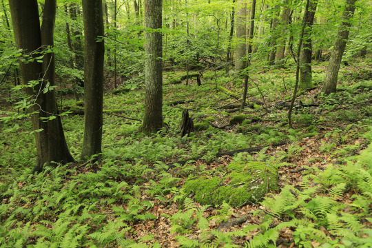
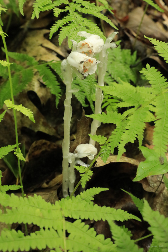
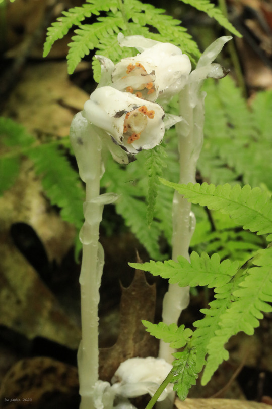

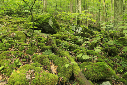

Some photos from earlier this afternoon along the Rhododendron Trail at Valley Falls State Park. The great rhododendron (Rhododendron maximum) is just now starting to bloom in NC-WV. I also found Indian pipe (Monotropa uniflora), a parasitic, herbaceous plant, and the gorgeous poke milkweed (Asclepias exaltata), a shade-tolerant perennial that favors open woodlands and forest margins.
#appalachia#vandalia#west virginia#wildflowers#flora#tygart valley river#valley falls state park#rhododendron trail#great rhododendron#indian pipe#ghost plant#ghost pipe#poke milkweed#early summer
104 notes
·
View notes
Video
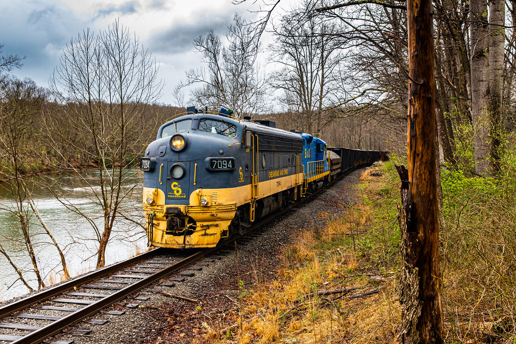
flickr
F Unit Freight por Kyle Yunker
Por Flickr:
Durbin and Greenbrier Valley Railroad F7(A) #7094 & GP9 #6530 pass along the banks of the Tygart Valley River nearing Belington,WV as they shove hard on 14 loads of rock.
8 notes
·
View notes
Text
Vascular flora along the Tygart Valley River near Arden, West Virginia
http://dlvr.it/PWK4X7
0 notes
Photo
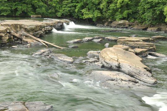
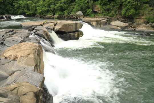

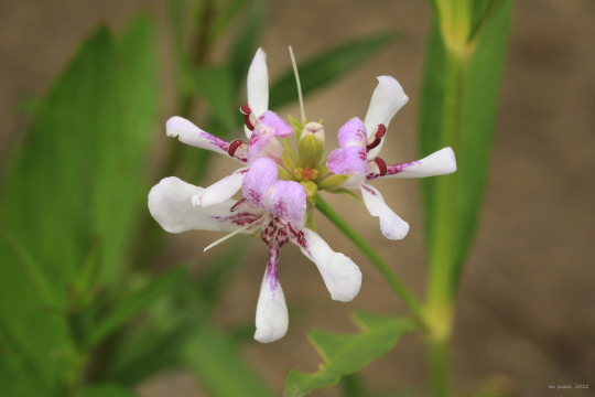

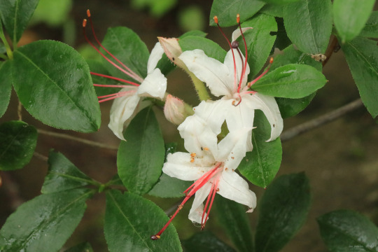
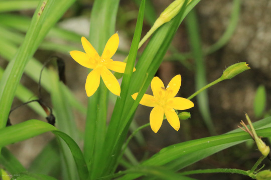

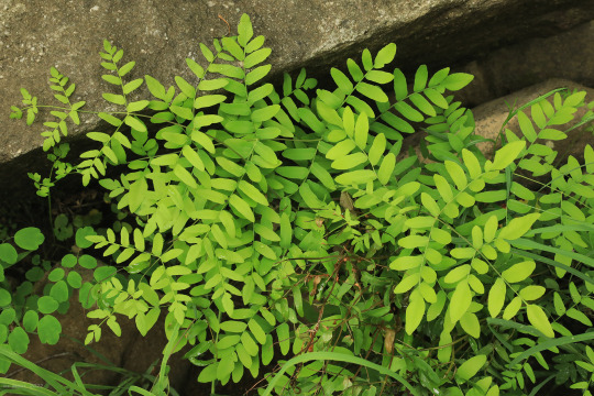
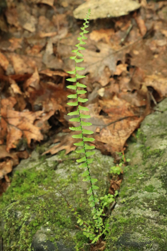
Valley Falls State Park is best known for the dramatic cascades and rapids formed by the Tygart Valley River as it “squeezes” through a narrow gorge on the way to its eventual confluence with the Monongahela River in Fairmont. The park was once the site of a grist mill in the mid-1800s, but the only evidence remaining today is a spillway, a grinding stone, and an abandoned quarry, now overtaken by forest. Falls notwithstanding, I’m ever in awe of the massive slabs of Upper Connoquenessing sandstone piled up on either side of the river - they provide both a testament to earth’s prehistoric past and an amazing riparian zone of rocky pools and sandy embankments where seeds from farther upstream can deposit and take root, providing homes to many uniquely-adapted species.
From top: American water willow (Justicia americana), a showy aquatic perennial that forms large colonies in the shallow riffles of streams; an eastern American toad (Anaxyrus americanus americanus), which was busy croaking and making babies in a rocky pool near the falls; sweet azalea (Rhododendron arborescens), also known as smooth azalea, a rangy, stream-loving shrub whose strongly-scented, white flowers have distinctive red stamens; yellow star grass (Hypoxis hirsuta), an exquisite riparian member of the lily family that clumps on the moist, sandy banks of fast-moving streams; royal fern (Osmunda regalis), a spectacularly beautiful fern that loves the nooks between the boulders at the river’s edge; and ebony spleenwort (Asplenium platyneuron), also known as brownstem spleenwort, an elegant, upright fern with a special fondness for the same rocky nooks.
#appalachia#vandalia#west virginia#tygart valley river#valley falls state park#waterfalls#rapids#riparian#connoquenessing sandstone#geology#spring#wildflowers#flora#amphibian#toad#anaxyrus americanus#american toad#justicia americana#american water willow#rhododendron arborescens#sweet azalea#smooth azalea#hypoxis hirsuta#yellow star grass#osmunda regalis#royal fern#asplenium platyneuron#ebony spleenwort#brownstem spleenwort
172 notes
·
View notes
Video
DGVR #7094 near Norton,WV por Kyle Yunker
Por Flickr:
Durbin & Greenbrier Valley Railroad's F7(A) #7094 and GP9 #6530 shove hard on 14 rock loads near Norton,WV in a light rain along the Tygart Valley River. DGVR #7094 was built for the Milwaukee Road in 1950 as F7(A) #109A and retired in February 1982 as KCS #110 before finding new life in West Virginia.
2 notes
·
View notes
Photo
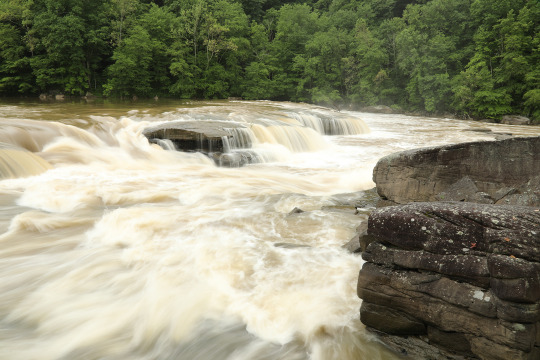
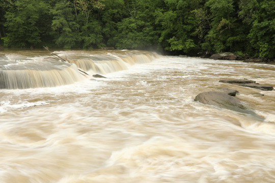
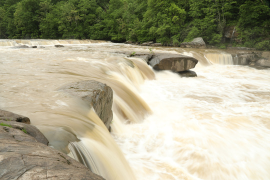


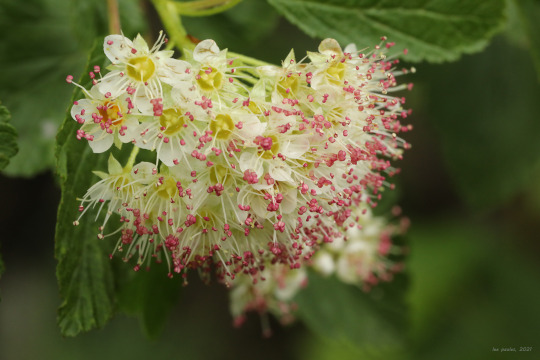
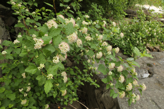
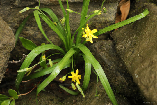
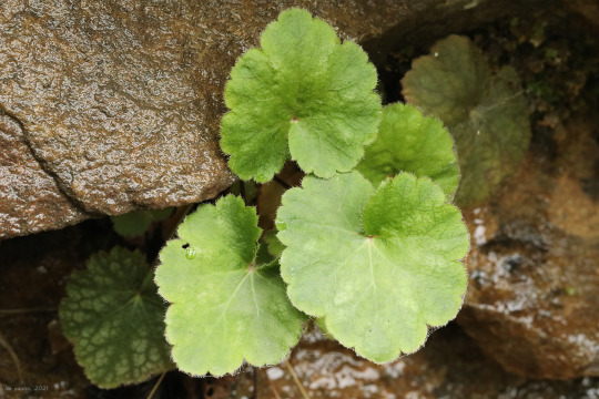

The terrible weather this weekend postponed my plans to get back up into the mountains until Monday, so I popped down to Valley Falls State Park instead to check out the arrowwood viburnum (Viburnum dentatum) and common ninebark (Physocarpus opulifolius), both now at peak bloom. These beautiful riparian shrubs put on quite a show at the end of May, soon to be followed by mountain laurel (Kalmia latifolia) and the stunning smooth azalea (Rhododendron arborescens), whose pure white flowers with pink-red stamens, lustrous green foliage, and large size make it my favorite azalea in the Appalachians. Other interesting stuff in bloom yesterday included yellow star grass (Hypoxis hirsuta) and American alumroot (Heuchera americana), a rock-loving saxifrage whose numerous cultivars are grown in gardens throughout the world. The Tygart Valley River, swollen by heavy rainfall from this past week, stole the show, however, with its turbulent whitewater reaching the top of the surrounding rock outcrops in places. I was amused a bit by the park staff, who pootled dutifully around the grounds in their golf cart to make sure the tourists kept their distance from the river.
#appalachia#vandalia#west virginia#spring#flora#wildflowers#viburnum#arrowwood viburnum#physocarpus#common ninebark#eastern ninebark#hypoxis#yellow star grass#heuchera#american alumroot#valley falls state park#tygart valley river
68 notes
·
View notes
Last Seen Blogs

kawa-baby
Untitled

tenaciousheartnacho
Untitled

lav-nd-r
lavender

made-in-russia
MADE IN RUSSIA

creepypastabookclub
New episodes every other Friday