#eminent domain
Text
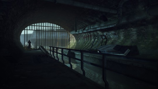


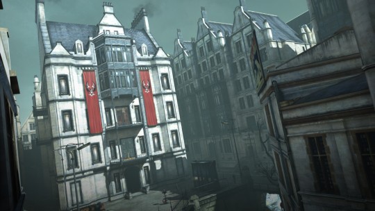
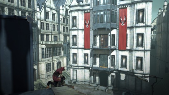
[The City of Dunwall - Legal District Docks]
#dishonored#knife of dunwall#eminent domain#video game scenery#video game screenshots#video game aesthetic#industrial aesthetic#revisiting dunwall like a tourist and taking pictures is my newest hobby
154 notes
·
View notes
Text
LONESOME LONG WAY HOME
Heading southwest of Martinaise
Courtyards = the abandoned housing and the fishing village?
Le Domaine Eminent
in North Jamrock, past the motorway
Main and Perdition appears to be the rough address for the Precinct
HEADING "HOME"
Past the 41st [heading east/west]
through the market
Boogie Street Spearhead
I think this means the north end since it stretches all the way to Faubourg in the south
Around meteor lake
turn on Voyager road past the video rental
PROBLEM
Let’s rewind. Let’s trace your drunken steps back home. Jump across the raised channel bridge south-west of here. Fall over. Get up. Get off the asphalt in 20 minutes, shuffle your feet through courtyards, scaring little children. Go under the great raised motor-tract, the 8/81, until you reach le domaine éminent in North Jamrock. The streets are frozen this time of year, caked with ice. Walk down Main, to Perdition -- there’s a side alley there and your footprints in the mud...
SOLUTION
...here we go. Home awaits. Walk past Station 41 and through the market. Past the Boogie Street spearhead to the other side of the lake -- the frozen eye at the center of the district. Then past the video rental store on the corner. There, at the end of a street lined with pine trees: a small house, no larger than a matchbox. 11 Voyager Road. You no longer live there. Those times are gone, and so are those people. Why did you come here? Why are you still here? And where’s the dealer? You have to get back to work. That’s all you have now.
20 notes
·
View notes
Text
Want to see something cool, but also kinda sad + anger-inducing?
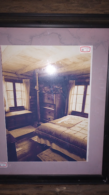
Today I went to a nearby state park, and hiked to this cabin:
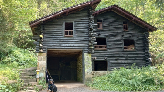
Hand-built by a local man named Armar Bordner in the 1930's, it was occupied by Mr. Bordner until his death in 1994. It's not for rent or anything; it's just sitting there, with all the doors and windows open, for anyone who's up for a mile-and-a-half hike to stop in and have a look around. There are a few framed photos on the walls showing how it looked when he lived there, and a couple of signs explaining the history.
And that's kind of a bold move, considering that, if you have any ability to read between the lines, the parks department really comes off bad in it.
Here's the sign:

A clearer and more detailed version of the text is available here, the site of a private conservation organization that maintains the cabin.
Mr. Bordner, who was an Industrial Arts teacher, bought the land and built the cabin by hand, with some help from friends and students, over a 2 1/2 year period ending in 1939. All of the logs for the cabin were felled and hewn by hand, he used local materials, mostly obtained at the site, and was reportedly inspired by Frank Lloyd Wright.
In the 1970's, the state decided that they wanted to create a state park in the area. The original plan was fairly elaborate, including damming the creek to create a lake for recreational boating, fishing, etc. (PA state parks have a lot of these "man-made lakes," mostly built in the CCC era or shortly after WWII.) Under eminent domain, the state seized private land--mostly hunting camps--for the project.
One of the seized properties was Mr. Bordner's cabin. He fought the seizure--I mean, who wouldn't?--and at some point the state apparently decided that it was not a great look to force a senior citizen out of the family home that he built with his own two hands, and granted him the privilege of continuing to live in it for the remainder of his life, for what is described as a "nominal fee."
Mr. Bordner went on to live two more decades, passing in his cabin in 1994, at the age of 90. During the decades since his cabin technically ceased to belong to him, the park project kind of fell apart. The park was officially formed in 1987, but it was considered an "undeveloped park"--meaning, it was public land, but the state wasn't doing anything to encourage people to visit it or accommodate them if they did--until 2012, when the parks department took an interest in developing it.
Now, in 2023, the park has several hiking trails, three parking lots with port-a-potties , and that's about it. (Most state parks here have things like campsites, picnic grounds, etc.) Some of the trails--the equestrian trails and the Swatara Rail-Trail--are on park land but maintained by other groups. As is the cabin itself, which was allowed to fall into disrepair after Mr. Bordner's death, and was restored by a group called the Swatara Watershed Association.
It's an absolutely beautiful cabin, in a lovely setting, and I'm glad I got to see and explore it--but once you learn the history, it's hard not to feel that it should still belong to Mr. Bordner's daughter. (Or, if she didn't want to live there or keep it up, to a group that Mr. Bordner had chosen while he was alive to preserve it and make it available to the community.)
Anyway, here are some more pretty photos:
Here's a big porch-balcony that looks out over the stream and waterfall:
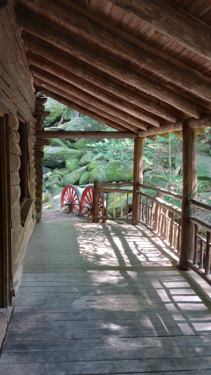
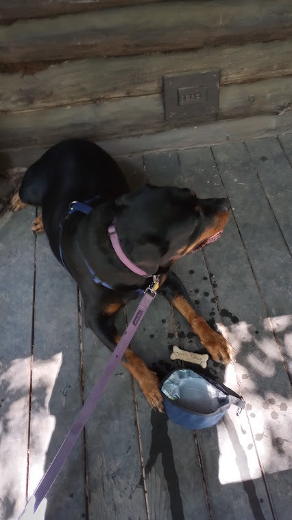
Sophie and I sat there to have a little snack after our hike:
Then we got to exploring the inside. Here we're in the main room looking out toward the waterfall:

And here we are on the other side of the window, looking in:
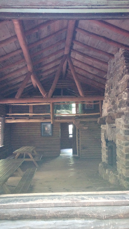
The main room, here, faces the creek/waterfall on two sides, as the stream wraps around it. Over to the right (from this POV), there is a small room that might have been a bedroom or kitchen. (There's a photo of a large woodstove for cooking in it, but the watershed or site seems to say it was a bedroom?) The balcony from the earlier picture is to the left, and at the far end of the cabin there's a staircase leading up to a loft, with some little bedrooms tucked under it.
Here's one of the framed photos on the wall, showing how this area looked at one point during Mr. Bordner's time there:

And my attempt at re-creating the photo from the same angle:

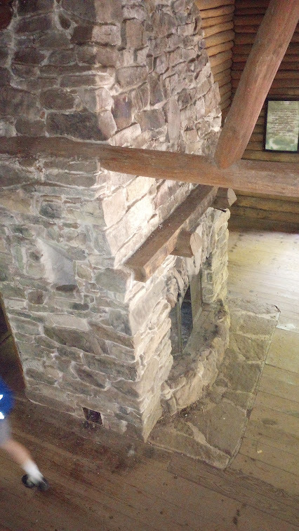
Here we're looking down from the loft, at the fireplace that Mr. Bordner built with stone collected on the site:
Another look at the fireplace:
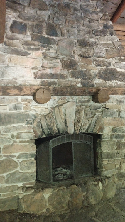
Surprisingly, there are no signs saying not to light a fire in it.
Here's a photo from the wall showing one of the small bedrooms:
And the room today:

And here's Sophie hanging out next to the post for the library hiking program:

That's about all I have--I thought I took some pictures of the waterfall, but I guess I didn't. The Watershed Association site has additional photos, if you want to see more. I definitely want to go back and see it another time.
22 notes
·
View notes
Text
From the December 9, 2023 article:
On Friday, the Libertarian Party of Iowa sent out a news release acknowledging an “approach by the Ramaswamy campaign” about potentially running for president as a Libertarian. Libertarian Party of Iowa Chair Jules Cutler said in the news release that the campaign’s inquiry is a “testament to the growing recognition that the spectrum of American political discourse must encompass diverse perspectives,” and praised the candidate’s recent focus on carbon-capture pipelines.
“Mr. Ramaswamy’s recent stance on the issue of eminent domain echoes the ideals held by many Iowans,” continued Cutler, “The Libertarian Party of Iowa has proudly collaborated with thousands across the state, from all parts of the political spectrum, united in the fight to protect property rights against the abuse of state power.”
7 notes
·
View notes
Text
youtube
Replace White Supremacy
#blaxploitation#melanin#black panther party of self defense#afeni shakur#2pac shakur#gentrification#eminent domain#urban renewal#unia#universal negro improvement association#garifuna#caribbean#africa#melanated#latinos#ghetto america#ghetto worldwide#black is beautiful#black family#black man#black woman#black child#black tumblr#Youtube
3 notes
·
View notes
Text
youtube
Strong Towns looks at how the highway-industrial complex conspires to devalue homes in order to plow unneeded high-speed roads through poor and minority neighborhoods.
5 notes
·
View notes
Text

"You, solely, are responsible for this..." - Crimson 1. (Work in progress!)
3 notes
·
View notes
Quote
No, he will just sip his regular tea, feel the silt of the years accumulate, both as ballast and as burden.
Carl Neville, Eminent Domain
27 notes
·
View notes
Text
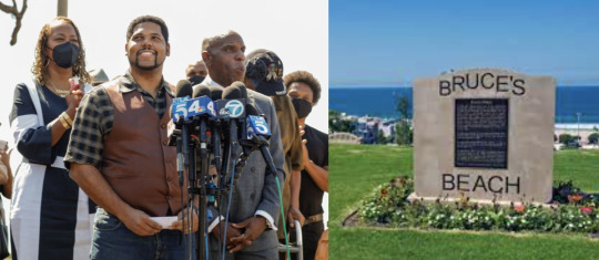
Return of Bruce's Beach in CA to Descendants of Charles and Willa Bruce Receives Unanimous Approval from LA Board of Supervisors
Return of Bruce’s Beach in CA to Descendants of Charles and Willa Bruce Receives Unanimous Approval from LA Board of Supervisors
[Photo: Anthony Bruce, the great-great-grandson of Charles and Willa Bruce, at Bruce’s Beach on Thursday. Photograph: Jay L Clendenin/Los Angeles Times/Rex/Shutterstock]
This week, in California, a case for reparations was finally won.
According to the Los Angeles Times, the Los Angeles Board of Supervisors voted their unanimous approval of the return of two oceanfront parcels unjustly taken by…
View On WordPress
#Anthony Bruce#Bruce&039;s Beach#California#Charles and Willa Bruce#eminent domain#Los Angeles Country of Supervisors#Manhattan Beach#reparations#Supervisor Janice Hahn
28 notes
·
View notes
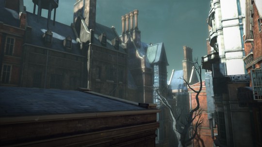
Text

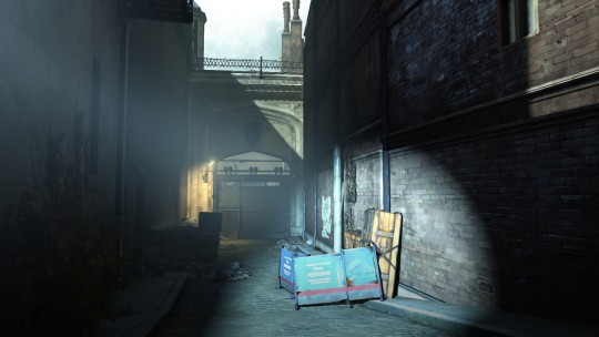

[The City of Dunwall - Legal District]
#dishonored#knife of dunwall#eminent domain#video game scenery#video game aesthetic#video game screenshots#industrial aesthetic#featuring billie lurk because she's the best
126 notes
·
View notes
Link
LOS ANGELES (AP) — Southern California beachfront property that was taken from a Black couple through eminent domain a century ago and returned to their heirs last year will be sold back to Los Angeles County for nearly $20 million, officials said Tuesday.
The heirs’ decision to sell what was once known as Bruce’s Beach was announced by Janice Hahn, chair of the county Board of Supervisors, and state Sen. Steven Bradford, who led local and state governmental efforts to undo the long-ago injustice.
“This fight has always been about what is best for the Bruce family, and they feel what is best for them is selling this property back to the County for nearly $20 million and finally rebuilding the generational wealth they were denied for nearly a century,” Hahn said in a statement.
Bradford, who authored the state legislation that enabled the land’s return, said he supported the heirs’ decision to sell it to the county because current zoning regulations would prevent them from developing it in an economically beneficial manner.
The land in the city of Manhattan Beach was purchased in 1912 by Willa and Charles Bruce, who built a small resort for African Americans on the south shore of Santa Monica Bay.
The Bruces suffered racist harassment from white neighbors, and in the 1920s the Manhattan Beach City Council condemned the property and took it through eminent domain. The city did nothing with the property, and it was transferred to the state of California and then to Los Angeles County.
The county built its lifeguard training headquarters on the land, which includes a small parking lot.
Hahn learned about the property’s history and launched the complex process of returning the property, including determining that two great-grandsons of the Bruces are their legal heirs.
Terms of the transfer agreement completed last June called for the property to be leased back to the county for 24 months, with an annual rent of $413,000 plus all operation and maintenance costs, and a possible sale back to the county for nearly $20 million, the estimated value.
So its that simple, the land was transferred back to the rightful owners and the county got to continue to use it for a little while as a tenant, paying rent, while the two parties negotiated to determine what was the best outcome for both parties. Transferring first rather than agreeing to just the buy out meant that the two could negotiate as equal parties, not from the position of the county having both the land AND the power.
5 notes
·
View notes
Text
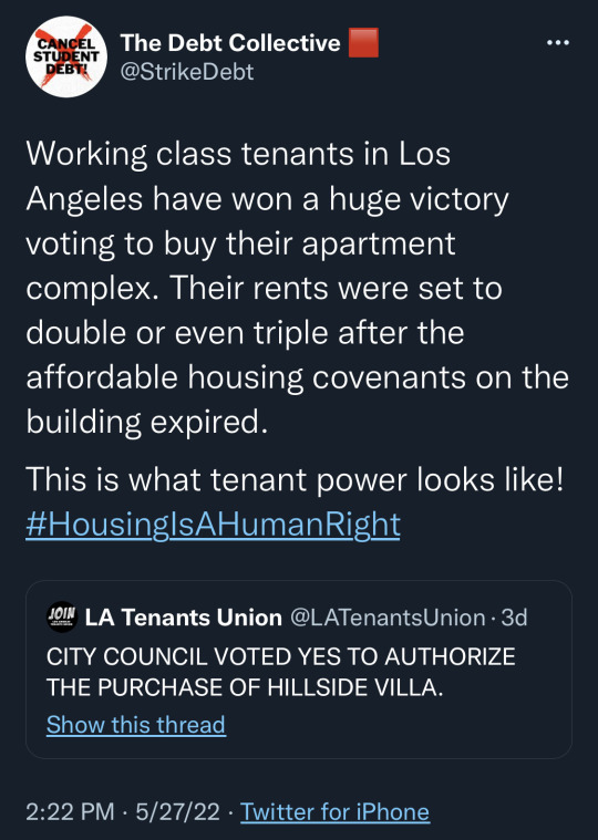

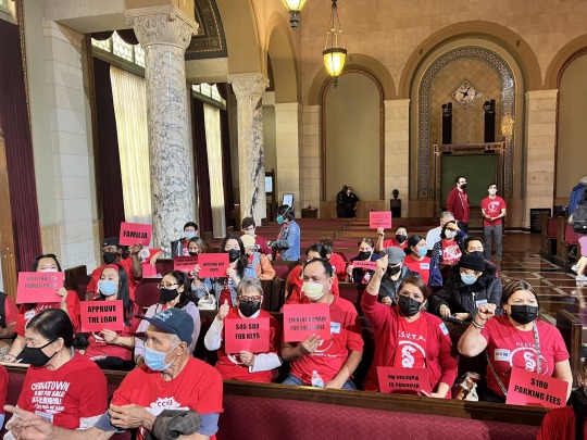


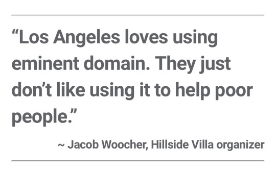
#housing#affordability#rent#housing is a human right#eminent domain#cancel rent#los angeles#good news#wins#hillside villa#chinatown#urban planning
14 notes
·
View notes
Text
1 note
·
View note
Text
Drax Hall Plantation - Eminent Domain minus Reparations means all lands are acquired for FREE. Listen. Learn.
https://youtu.be/mld1OEHLEQE
In an era of Reparations, ALL PLANTATIONS should be subject to Compulsory Acquisition (Eminent Domain) and given to THE PEOPLE with charges ($$$) shouldered by plantation owners. In other words, if you own a plantation, you own nothing! Have your say. Naked!!
youtube
Like/share/comment/subscribe on YouTube (it costs you nothing). Press the notification bell 🔔. NEW WhatsApp #2527225512
#Drax hall plantation#eminent domain#barbados#naked departure#compulsory acquisition#reparations#Youtube
0 notes
Text
“Warren Knight of Smiling Hill Farm is eagerly awaiting a public forum Monday on the proposed Gorham Connector that would cut a swath through the farm that has been in his family for 13 generations.
(…)
The turnpike authority will have an open house at 4:30 p.m. on Monday, March 25, at Shaw Gym in Gorham for the public to discuss the connector with Executive Director Peter Mills and other staff members, engineering consultants and municipal officials. A formal presentation is set for 6 p.m. followed by a public comment session.
To ease traffic congestion on routes 22 and 114, which see an average of 22,000 vehicles daily where they overlap, according to the Maine Department of Transportation, the turnpike authority plans to build a 4.8-mile, four-lane toll highway linking the Bernard Rines Bypass roundabout on South Street in Gorham with Exit 45 in South Portland.
(…)
The 500-acre Smiling Hill Farm has land in Gorham, Scarborough and Westbrook.
The turnpike authority wants to buy 47.3 acres from the 500-acre Smiling Hill for a portion of the connector’s right of way, according to Mills. Of those 47 acres, 32.5 are “mostly woodland” on the north side of County Road and 14.8 are on the south side that Mills said Knight bought four years ago. Mills said the 14.8 acres was “never part of (the original) Smiling Hill Farm.”
The turnpike authority should have bought the 14.8 acre parcel when it went on the market, but “we didn’t get there in time,” Mills said.
Knight, who operates the farm with his siblings, said the acreage the turnpike authority wants to buy is in Scarborough, and the plan divides the farm, cutting off another 50 acres in addition to the land for the right-of-way strip.
(…)
Besides hayfield and pasture, the farm uses a sugar bush to collect sap for maple syrup production and the forest land to harvest cordwood and lumber, Knight said, adding that the woodland also is a habitat for wildlife important to the farm.
(…)
The farm has been in the Knight family for 13 generations beginning in 1720, Knight said. Decades before the American Revolution, the farm was the 1744 burial site of the British royal mast agent Col. Thomas Westbrook, brother-in-law of early Scarborough settler Nathan Knight.
(…)
The division of the Smiling Hill land has generated a groundswell of opposition. A “Protect Smiling Hill Farm” Facebook page created once the turnpike authority’s plans became known has 2,400 members.
“We’re hopeful to have supporters there,” Knight said about Monday’s meeting.”
“A new federal report shows there are fewer farms now in Maine than there have been in more than 25 years.
The United States Department of Agriculture released results of the 2022 Census of Agriculture, showing in 2022 there were an estimated 7,036 farms with 1.23 million acres of farmland, down from a peak of 8,173 operations and 1.45 million acres in 2012. Maine lost 564 farms and 82,567 acres of farmland since the last census in 2017.”
1 note
·
View note
Last Seen Blogs

toa-kirhan
Toa Kirhan's Domain

cileke
Untitled

ottoog3
POMETTROPOLIS

fuckerjeeepyyy
Loffa

freckledsweetpea
the inner machinations of my mind are an enigma