
blue-car-road-tripper
Blue-Car-Road-Tripper
Dream. Plan. Drive.
263 posts
Don't wanna be here? Send us removal request.
Last Seen Blogs

fettuccin-e
Southern Skies.

acarlsen
Untitled

askfreja
Ask Freja: the shiny gardevoir

fruitncream
we are just like romeo and juliet-

owari-no-utashuu
終のウタシュウ ~ Owari no Utashuu
Text
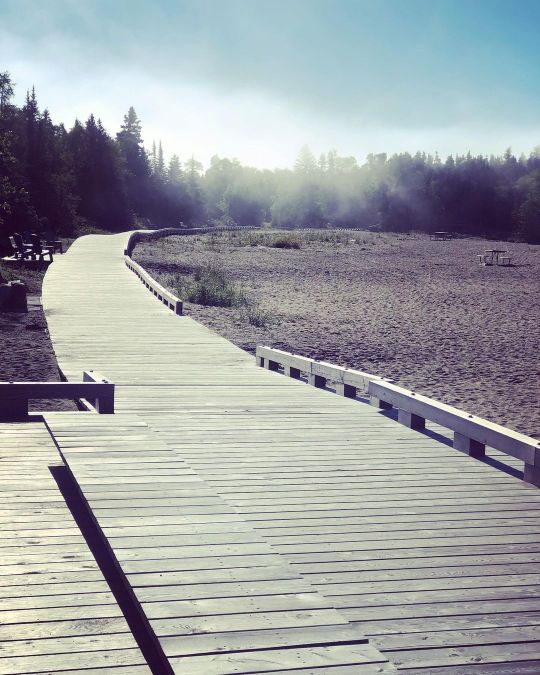
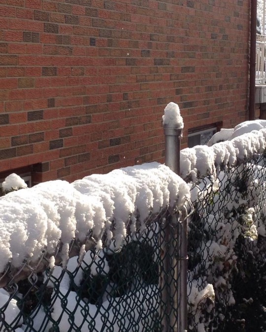
#roadtrip#summer#highway#travel#travel ontario#canada#lake superior#bluecarroadtripper#lake superior provincial park#batchawana bay#adventure time#explore
0 notes
Text
use the outhouse and pay respects in an isolated area north of Duluth 😆 …… a well needed bathroom break had us stopping at this cemetery when we eyed an outhouse in the back of it. 🤷🏼♀️

1 note
·
View note
Text
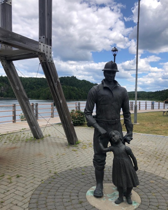
📍Elliot Lake Miners’ Memorial
….. How many times have I passed by the turnoff along the highway to go to Elliot Lake? … many, many times that’s for sure. This time last year I had Elliot Lake on my agenda and went for a visit. The memorial is beautiful and the views stunning. When you walk around and read the names of loved ones lost in the mining industry in this town it is heartbreaking and sad. The memorial is a beautiful tribute to these men and women ❤️ … the monument area has picnic tables and a great parking area. You can sit and look out at the great views which once were where the mines were located and now are reclaimed by nature. Of note, The majority of the world's uranium - used for Cold War nuclear arms and electricity production - originated in Elliot Lake.
Elliot Lake's Miners' Memorial Park, located on the shores of Horne Lake, is home to the Mining Monument, the Miners' Memorial, and the Prospectors' Monument. The park is dedicated to the area's heritage and history of uranium mining. There is parking and picnic tables available off of Highway 108 in Elliot Lake.
All of the monuments were designed and created by local artist Laura Brown Breetvelt. Visit Laura's website to see more of her work.
•Prospectors' Monument
The Prospectors' Monument is the newest installment in the Miners' Memorial Park. This monument honours all of the early prospectors who staked our area and discovered uranium deposits.
•Mining Monument
The monument offers information on the history of mining in Elliot Lake by celebrating the families who transformed a rural community into the Uranium Capital of the World.
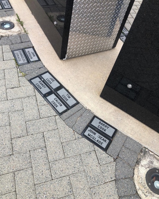
•Miners' Memorial
The Miners' Memorial Wall is engraved with the names of workers from Elliot Lake's mines who have died from workplace accidents or occupational illnesses.


#roadtrip#summer#highway#travel#travel ontario#lake superior#bluecarroadtripper#small town ontario#mining
3 notes
·
View notes
Text
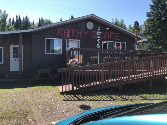
Another gem I found via the posts on social media…..
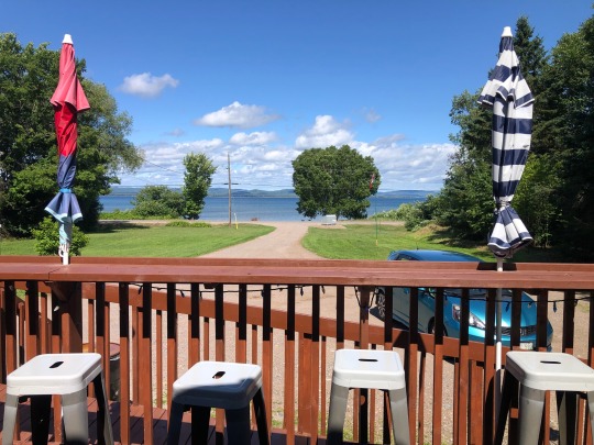
Kathy’s Cafe located down the 563 Batchawana Bay.
Homemade food.
All day breakfast 🍳
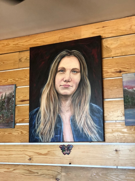
…. Talking to the owner, this cafe came to be after the passing of her 42 year old daughter Kathy in a car accident. The two of them had wanted to open a cafe and tried for years but were unsuccessful. After Kathy’s passing, her mom decided to try again and now has a beautiful cafe in her daughters honour 💕 …
A beautiful portrait hangs in the cafe in tribute of her gorgeous daughter (see picture).
If you’re in the area this is a wonderful and quiet place to dine and every day she has a special. I’ve heard that her pizza is amazing too !!! Oh, and DO NOT forget to buy a cinnamon bun because they are delicious !!! 🚙 …. Kathy’s Cafe


#foodblogfeed#foodstagram#travel ontario#small town ontario#batchawana#batchawanabay#highway 17#summer#highway#lake superior#lake superior provincial park#travel#canada#bluecarroadtripper
0 notes
Text

There once was a cow who escaped a transport accident. He was sighted along highway 17 North roaming free and enjoying his freedom. Nobody thought he would survive a northern Ontario winter, especially up beside Lake Superior. But, he did!!!!
He was tracked and found and along with him they found two escaped steers. Guess I won’t have to look for him on my travels now 😆🚙
STORY BELOW ⬇️
UPDATE:
Wawa cow tracking updates! To those who thought the cow left on highway may not have survived the winter or thought was shot. It was not!
Thank you to the team effort groups organized in assisting tracking the cow. We named him Tucker. (Reference article cottage life)
Thank you to the man, woman, sons, all organizers in group networking, drivers, trucker, and trackers, dispatch, opp, wawa gas station, plow guys, and tips!
TUCKER SURVIVED THE WINTER, He also was not alone. Two steers where found for the month end of may reported in, and picked up! No news, fake news, and good news….. 🐮🐮🐮🐮🐮🐮🐮🐮🐮🐮🐮 it was an eventful few months learning about and tracking, to almost wits end our groups tried. Thank you to the finders! The survival skills adapted on these steers. Miracle is the name of the other steer.
#roadtrip#summer#highway#travel#travel ontario#lake superior provincial park#batchawana bay#lake superior
1 note
·
View note
Text
Victoria Beach Road Trip
Up at the top of highway 59 North is a beach town called Victoria Beach, Manitoba.
A few weeks back I decided to do more exploring in Manitoba so I thought I’d go to Victoria Beach.
Located at the northern point of highway 59 and surrounded by the water of Lake Winnipeg, I figured what a glorious place to just sit by the water and take it all in.
There were a few problems with that. One is that there is no public parking anywhere. Second, there are no facilities (washrooms) anywhere and spending an hour trying to find a place to pee was crazy. Thankfully the side of the road is always available. Third, it’s not really a place for tourists and they’ve made it that way.
In this little beach community they have a store, a bakery (which was sold out and closed), tennis courts, playground and a “restaurant” called Moonlight Inn.
I landed up talking to a lady at the store who was admiring my “Toronto vs Everyone” T-shirt and I asked about the restaurant to which she said it was great food and an excellent place to eat. So, off we went to grab some food as we hadn’t eaten since early that morning.
Inside it’s dark, lopsided and run down. We didn’t even stay to order food. After a quick drive we found a place to park and walked down to the water to enjoy that. Apart from being a windy day and the temperature by the lake being cool, we enjoyed the sounds of the water and waves for 10 minutes, walked back to our car and left for home.
My takeaway from the road trip were that some towns or cottage communities don’t want tourists and as such have made it difficult to access beaches with no parking available.
Thoughts for future Manitoba exploring are to check out Grand Beach Provincial Park where they have lots of parking, washroom facilities and welcome road tripping tourists with open arms. I’ve done a trip to Gimili, Manitoba which is a beach/tourist town and has great restaurants and shops as well as ample amount of parking available. Maybe I’ll just head back up there …….


3 notes
·
View notes
Text
…….
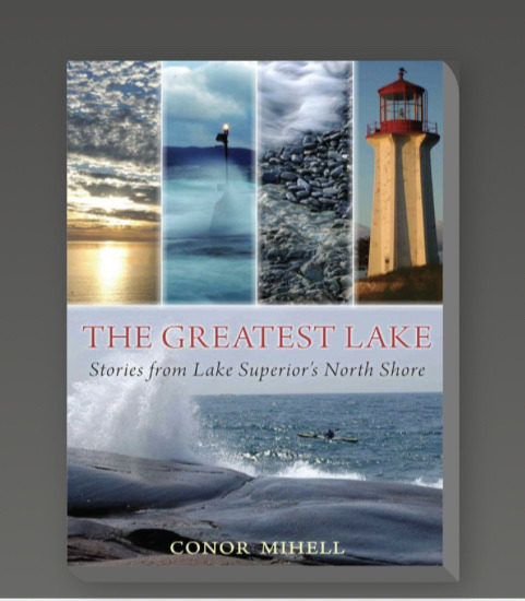
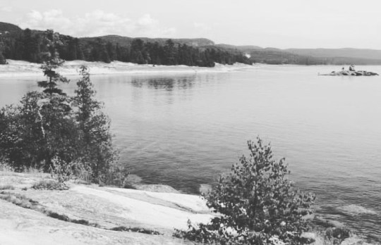
Finally finished this book today.
It’s heartwarming reading a book when you can visually put yourself in the places the author talked about.
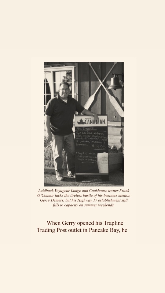
Back in 1980 I worked at Pancake Bay Provincial Park and frequented Agawa Crafts which was right across the highway. It was a bustling place those days !!! Years later, I would drive by Voyageurs Lodge without blinking an eye or stopping to check it out. Then, one summer I booked a stay there and I’ve been hooked since. Every summer I return and stay there, enjoying the fritters, food and the amazing customer service.
This book just highlighted to me why the Canadian North shore of Lake Superior is so special.
📷 photos are screen shots from the book.
#lakesuperior #batchawanabay #pancakebay @pancakebaypp @lakesuperiorpp #voyageurslodgeandcookhouse #roadtrip #northshore #travelon #exploreontario 🚙

5 notes
·
View notes
Photo
📍BATHTUB ISLAND
Getting there: 🚙 🏃🏻
Bathtub Island is best accessed by parking at Katherine Cove and following the Coastal Trail south for about a ½ kilometre. Parking on the shoulder is discouraged for safety reasons, and “No Parking” signs were posted along the highway in 2018 near the entrance to a shortcut path to the beach opposite the island.
.
.
Visitor Responsibilities: 📝
.
Lake Superior Provincial Park is classified as a natural environment park. We can all help to keep it that way by:
.
Respecting the fragility of the dunes environment. Tread lightly and follow the worn path to the beach without developing your own way there.
There are no toilets or garbage bins here. 🚽 Practice backcountry etiquette by packing out whatever you bring in, including used toilet paper/tissues, and leaving no trace, other than your footprints in the sand. 🦶
.
.
Adhering to park rules regarding camping, cans, bottles and fires which are are prohibited.. 🛑 ✋🏻
.
.
What you’ll find when you get there: 👀
.
Bathtub Island is aptly named because of a depression at one end of the island that collects water whenever the waves are whipped up high enough. You probably won’t be tempted to sit in this bathtub though, the water may have been sitting there for some time! 🛀
.
.
Once you reach the beach, turn left and walk toward the point that is also the shortest between the beach and the island. 🏖
As you approach the point, a sandbar will reveal itself to you and this will serve as your “bridge” to the island. The sandbar won’t keep you dry though – expect to get your bottom wet so hang your camera equipment accordingly!
.
.
Getting up onto the island is a little bit tricky as well – the smooth round rock, which may be wet, will require you to lean forward as you make your way up the embankment (only 3 feet or so). Once on the island, and if the weather conditions are right, you may be tempted to spend at least an hour on this tiny piece of land while you hop from one outcrop to the next, or explore the features of the rock, or simply decide to sunbathe. ☀️ @lakesuperiorpp #bathtubisland #travelontario #ontariotravel #ontariotourism #lakesuperiorcircletour (at Northern Ontario, Canada)
https://www.instagram.com/p/Cj-85U9pGQu/?igshid=NGJjMDIxMWI=
2 notes
·
View notes
Photo
📍Up beyond the clouds, in ancient ground, so they say, and many men have died trekking up that away …
#terracebay @yourterracebay roadtrip 🚙 (at Northern Ontario, Canada)
https://www.instagram.com/p/CkRqtVXrYqw/?igshid=NGJjMDIxMWI=
1 note
·
View note
Text
Journey to Ruby Lake ….
The day started like any other day when on the road. We woke up, grabbed breakfast and decided to head to a trail that had amazing views. My daughter had found this trail and read the reviews. We plugged in the directions and off we drove ……
We had stayed the night in Thunder Bay and were on our way to a weekend in Terrace Bay. Just some mother/daughter down time to enjoy the open road, food and time together. And also Lake Superior !! ….
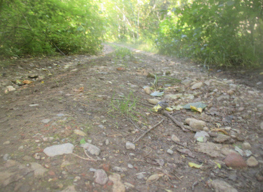
We made the turn onto the road that leads to the trail, crossed a set of railway tracks and continued on. It wasn’t long before the road became somewhat rough and started to literally close in on the car. At this point, having already invested time going down this road, and with my speed greatly decreasing to about 10km/hr, we decided to keep pushing on. Maybe we were driving on a dried up river bed ? The branches of bushes were touching the sides of my car at this point (and yes, in my mind I was having anxiety of what the damage would be) but we kept driving.
We must have looked at each other a million times wondering if this was actually the real way and even a real road. There was no signs and no indication this was actually leading to this trail. Every time I moved to avoid another pothole we would laugh because it was a non stop challenge to avoid the ruts. It was so bad that my daughter took a video of the drive just to prove how insane we were to drive it. We would probably even have trouble doing a three point turn if we wanted to return to the highway.
I’m not sure how long it took us to reach the end of that road where the trailhead was supposed to be but it seemed like forever.
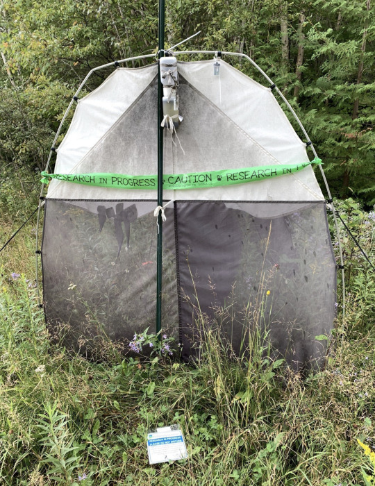
We parked and my daughter went to see where the trail was. Again, there were no signs or any indication a trail was here. Then, we saw a tent. Seeing this it kinda freaked us out thinking maybe a person was living there. It turned out to be a big collection tent for some study. I guess someone likes to study bush bugs. Phew!!!
Trying to look on an AllTrails map was impossible as there was zero cell service at this point. We had a great laugh when we actually said out loud that we could be lost and stuck here and would have to hike back out. That would have sucked considering the bugs were just awful !
Eventually we made a plan. My daughter decided to walk up some trail we saw to see if it was “the way” … off she went while I waited in the car hoping she would find the trail. In no time she was back and reported that she just wasn’t sure if that was the trail. She reported that the bugs were horrendous too.
We ditched the hike idea, headed back down the rough pothole skinny road and back to the highway. The day wasn’t a lost cause. We then decided to drive down to Silver Islet and Sleeping Giant Provincial Park for another adventure. The video she took and the pictures always give us a laugh remembering that drive and remembering the fun time we had together.

2 notes
·
View notes
Text
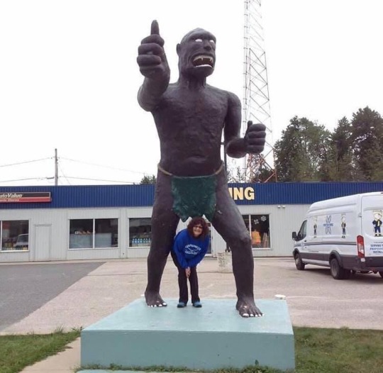
Summer road trips always have me finding some cool stuff.
Take for instance this statue of this guy thingy .... always remember to stop and get a picture with the things you see along the way...
Small towns are so awesome because they always seem to have hidden treasures.
FYI ——-> Ignace is a township in the Kenora District of Northwestern Ontario, Canada, located at Highway 17 and Secondary Highway 599, and on the Canadian Pacific Railway between Thunder Bay and Kenora. It is on the shore of Agimak Lake, and as of 2016, the population of Ignace was 1,202.
2 notes
·
View notes
Text

📍Toronto, Ontario 2013
The winter storm.
Flew via Air Canada and arrived at 11:50 a.m.
Power had been out at my parents place since Saturday December 21st. Lucky for them their neighbour had power so my dad ran a long extension cord from his furnace to the neighbours outlet in his garage. They had heat!!!!
Ate Christmas dinner at the Mandarin Restaurant and on Boxing Day the power came back on at their house. Yippee! A wonderful winter wonderland vacation.
#memories #christmas #christmasstory #holiday #winter #storm #2013 #toronto #memory 🎄🚙
#roadtrip#highway#travel ontario#travel#lake superior#canada#bluecarroadtripper#ontario#blue cars#adventure#christmas#winter storm#toronto#torontovseverybody
0 notes
Text
Summer road trips always have me finding some cool stuff.
Take for instance this statue of this guy thingy .... always remember to stop and get a picture with the things you see along the way...
Small towns are so awesome because they always seem to have hidden treasures.
FYI ——-> Ignace is a township in the Kenora District of Northwestern Ontario, Canada, located at Highway 17 and Secondary Highway 599, and on the Canadian Pacific Railway between Thunder Bay and Kenora. It is on the shore of Agimak Lake, and as of 2016, the population of Ignace was 1,202.
#roadtrip#summer#highway#travel#travel ontario#canada#bluecarroadtripper#northern ontario#blue cars#adventure#ignace
2 notes
·
View notes
Text
Journey to Ruby Lake ….
The day started like any other day when on the road. We woke up, grabbed breakfast and decided to head to a trail that had amazing views. My daughter had found this trail and read the reviews. We plugged in the directions and off we drove ……
We had stayed the night in Thunder Bay and were on our way to a weekend in Terrace Bay. Just some mother/daughter down time to enjoy the open road, food and time together. And also Lake Superior !! ….
We made the turn onto the road that leads to the trail, crossed a set of railway tracks and continued on. It wasn’t long before the road became somewhat rough and started to literally close in on the car. At this point, having already invested time going down this road, and with my speed greatly decreasing to about 10km/hr, we decided to keep pushing on. Maybe we were driving on a dried up river bed ? The branches of bushes were touching the sides of my car at this point (and yes, in my mind I was having anxiety of what the damage would be) but we kept driving.
We must have looked at each other a million times wondering if this was actually the real way and even a real road. There was no signs and no indication this was actually leading to this trail. Every time I moved to avoid another pothole we would laugh because it was a non stop challenge to avoid the ruts. It was so bad that my daughter took a video of the drive just to prove how insane we were to drive it. We would probably even have trouble doing a three point turn if we wanted to return to the highway.
I’m not sure how long it took us to reach the end of that road where the trailhead was supposed to be but it seemed like forever.
We parked and my daughter went to see where the trail was. Again, there were no signs or any indication a trail was here. Then, we saw a tent. Seeing this it kinda freaked us out thinking maybe a person was living there. It turned out to be a big collection tent for some study. I guess someone likes to study bush bugs. Phew!!!
Trying to look on an AllTrails map was impossible as there was zero cell service at this point. We had a great laugh when we actually said out loud that we could be lost and stuck here and would have to hike back out. That would have sucked considering the bugs were just awful !
Eventually we made a plan. My daughter decided to walk up some trail we saw to see if it was “the way” … off she went while I waited in the car hoping she would find the trail. In no time she was back and reported that she just wasn’t sure if that was the trail. She reported that the bugs were horrendous too.
We ditched the hike idea, headed back down the rough pothole skinny road and back to the highway. The day wasn’t a lost cause. We then decided to drive down to Silver Islet and Sleeping Giant Provincial Park for another adventure. The video she took and the pictures always give us a laugh remembering that drive and remembering the fun time we had together.
2 notes
·
View notes
Photo

📍Happy #TakeAHikeDay! Did you know a walk in the woods can help alleviate mental fatigue, and improve creative thinking. Hiking is also great for cardiovascular health and muscle tone. My favourite hiking places are Lake Superior Provincial Park & Pukaskwa National Park. Where do you enjoy hiking 🥾?? ##lakesuperior #algoma #ontario #travelontario #ontariotravel #worldenders #northshore #thesoo #adventure #explore #bluecarroadtripper #honda #greatlake #provincialpark #highway17 #vacation #hiking #hike (at Northern Ontario, Canada) https://www.instagram.com/p/ClElAxEp1D2/?igshid=NGJjMDIxMWI=
#takeahikeday#lakesuperior#algoma#ontario#travelontario#ontariotravel#worldenders#northshore#thesoo#adventure#explore#bluecarroadtripper#honda#greatlake#provincialpark#highway17#vacation#hiking#hike
0 notes
Text
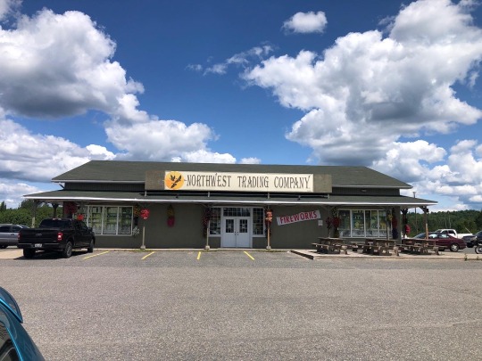
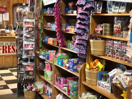
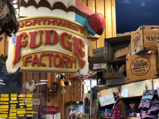
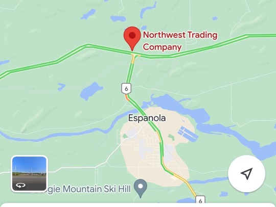
📍Northwest Trading Company
…. 327 Hwy 17, McKerrow, ON
This intersection with the Northwest Trading Company, Tim Hortons and Wendy’s has been a must stop for every roadtrip dating back to when my kids were small ….
First stopping here with my parents as we headed back to Toronto, the kids loved looking at the store and getting an ice cream. We’d take a washroom break, order some coffee and donuts and be on our way.
Flash forward to recent years and this place has now become my “must stop” break place. I always enjoy a walk around the Trading Post and a large coffee before hitting the road again. 🚙 …. Next time you’re passing by make sure to stop in and grab an ice cream cone !!!!
Great ice cream...dare you to get the triple scoop!
Nice staff, unique gifts, good fudge, clean bathrooms!
If you are travelling highway 17, stop here. #happytravels
#roadtrip #bluecar #bluecarroadtripper #bluecarrotadventures #espanola #mckerrows #tradingcompany #highway17


0 notes
Photo
….. 📍Brereton Lake, Whiteshell Provincial Park …. Another stop on my last road trip of the season on November 5th 2022 🚙 #adventure #whiteshell #campground #provincialpark #travelmanitoba #manitoba #roadtrip #teamhonda (at Brereton Lake South Beach) https://www.instagram.com/p/Ck3olctL1Hm/?igshid=NGJjMDIxMWI=
0 notes