#lithostratigraphy
Text
WORDPLAY WEDNESDAY: STRATIGRAPHY
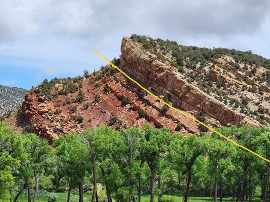
Stratigraphy is an important piece of vocabulary for paleontology. It is a branch of geology concerned with the relative position of strata (rock layers) and their relationship to the geologic time scale. It is primarily used for sedimentary and igneous rocks (metamorphic rocks don't tend to layer).

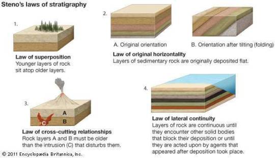
Nicolas Steno, a Catholic priest, established the basis for stratigraphy by introducing the Law of Superposition, the Principle of Original Horizontality, and the Principle of Lateral Continuity.
In other words, all rocks are deposited horizontally,

are laterally continuous,
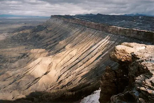
and the oldest rocks are on the bottom.

There are three major branches of stratigraphy: lithostratigraphy, biostratigraphy, and chronostratigraphy.
Lithostratigraphy looks at the variations in lithology (physical characteristics of rocks) such as vertical and lateral bedding, and reflects changes in depositional environment (river, lake, desert).
Biostratigraphy correlates rock layers using fossils. This is based off of William Smith's Principle of Faunal Succession.
wherein fossils flora and fauna succeed each other in vertical layers and can be found over wide horizontal distances.

Lastly, there is chronostratigraphy which aims to put an absolute date (an actual number) rather than a relative date on rock strata. This means we can tell you where on the geologic time scale a formation belongs as shown below.
I personally love stratigraphy. It involves a lot of rigorous outdoor adventuring including hiking, mapping, drawing, picture-taking, and sample collection. In fact, I am currently working on a stratigraphic paper for our Evil Tree Bonebed. It's taken a few years but we should be done soon! I'll share when we are finally published!
#paleontology#stratigraphy#lithology#lithostratigraphy#biostratigraphy#chronostratigraphy#deep time#index fossils#science#terminology#geology
18 notes
·
View notes
Text
Stratigraphy: Stratigraphy is a branch of geology which studies rock layers and layering (stratification). It is primarily used in the study of sedimentaryand layered volcanic rocks. Stratigraphy includes two related subfields: lithologic stratigraphy or lithostratigraphy, and biologic stratigraphy or biostratigraphy.
0 notes
Text
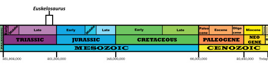
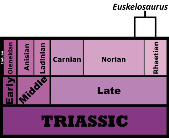
Euskelosaurus browni
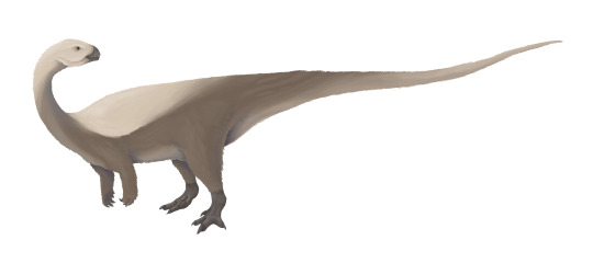
By Jack Wood
Etymology: Good Leg Reptile
First Described By: Huxley, 1866
Classification: Dinosauromorpha, Dinosauriformes, Dracohors, Dinosauria, Saurischia, Eusaurischia, Sauropodomorpha, Bagualosauria, Plateosauria, Plateosauridae
Status: Extinct
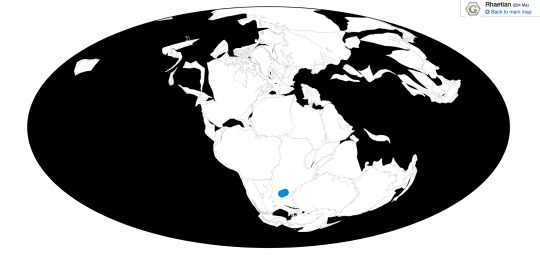
Time and Place: Around 210 to 205 million years ago, from the Norian to the Rhaetian ages of the Late Triassic
Euskelosaurus is known from the lower Elliot Formation of South Africa
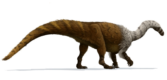
Physical Description: Euskelosaurus would have been a somewhat large, robust early sauropodomorph, possibly ten meters in length. It probably would have had long arms with long claws on the fingers, but they wouldn’t have had long enough arms to reach the ground. Euskelosaurus would have also had robust legs and a long tail. Its neck would have been long, ending in a small head. It might have been covered in some sort of fluffy covering, though we can’t be sure. It probably would have been quite heavy in general.
Diet: Euskelosaurus would have probably been an herbivore, most likely a mid-level browser.
Behavior: It is difficult to say exactly what the behavior of Euskelosaurus would have been, given it’s known from kind of poor remains. However, we can guess some things. Based on relatives like Massospondylus and the dinosaur family tree in general, it probably took care of its young. Based on other prosauropods, it probably lived in herding groups. And, given its size, it probably spent most of its time eating plant food. It also would have been active and warm-blooded, but not very fast. It’s claws could have been used to strip leaves off of branches, and its small head would have been able to weave in between dense foliage.
By Scott Reid
Ecosystem: Euskelosaurus lived in the Elliot Formation, a famous fossil ecosystem of Triassic to Early jurassic age animals showcasing how life evolved around the Triassic-Jurassic extinction and how dinosaurs began to explode into new forms right after the extinction. Unfortunately, Euskelosaurus hails from the early part of that ecosystem - the more poorly known Triassic member, where dinosaurs are few and far between, as are other animals. This makes Euskelosaurus important, being one of few dinosaurs known from this ecosystem, but also explains its poor condition. This was a semi-arid floodplain and lake system, with very long dry seasons and flash-in-the-pan wet seasons. It was primarily filled with conifers, as well as some horsetails and cycads.
It’s difficult to say exactly what animals Euskelosaurus lived with, given that the organization of the formation is murky and there are animals that are actually in the Upper Elliot Formation that were originally said to be in the Lower. However, Euskelosaurus probably lived alongside other Sauropodomorphs, including Eucnemesaurus, Plateosauravus, Blikanasaurus, and maybe others. There would have also been cynodonts, weird crocodile relatives, and even predatory dinosaurs. Until more is sorted out, however, it’s difficult to say.
Other: Euskelosaurus was a prosauropod, a type of dinosaur from which the larger sauropods would evolve at the end of the Triassic. It seems to be closely related to the better known Plateosaurus.
~ By Meig Dickson
Sources under the Cut
Bordy, E.M.; Eriksson, P. (2015-09-01). "LITHOSTRATIGRAPHY OF THE ELLIOT FORMATION (KAROO SUPERGROUP), SOUTH AFRICA". South African Journal of Geology. 118 (3): 311–316.
Broom, R. (1911). "On the dinosaurs of the Stormberg, South Africa". Annals of the South African Museum. 7: 291–308.
Cooper, M.R. (1980). "The first record of the prosauropod dinosaur Euskelosaurus from Zimbabwe". Arnoldia Zimbabwe. 9 (3): 1–17.
Durand, J.F. (2001). "The oldest juvenile dinosaurs from Africa". Journal of African Earth Sciences. 33 (3–4): 597–603.
Galton, Peter M. (1985). "Notes on the Melanorosauridae, a family of large Prosauropod Dinosaurs (Saurischia: Sauropodomorpha)". Geobios. 18 (5): 671–676.
Gauffre, Francois-Xavier (1993). "Biochronostratigraphy of the Lower Elliot Formation, southern Africa) and preliminary results on the Maphutseng dinosaur. Saurischia: Prosauropoda) from the same Formation of Lesotho". In Lucas, Spencer G.; Morales, Michael (eds.). The Nonmarine Triassic: Bulletin 3. pp. 147–9.
Huxley, TH (1866). "On the remains of large dinosaurian reptiles from the Stormberg mountains, South Africa". Geological Magazine. 3: 563–4.
McPhee, Blair Wayne (2016). The South African Mesozoic: advances in our understanding of the evolution, palaeobiogeography, and palaeoecology of sauropodomorph dinosaurs (Thesis).
McPhee, Blair W.; Choiniere, Jonah N. (2016). "A hyper-robust sauropodomorph dinosaur ilium from the Upper Triassic–Lower Jurassic Elliot Formation of South Africa: Implications for the functional diversity of basal Sauropodomorpha". Journal of African Earth Sciences. 123: 177–184.
McPhee, B. W., E. M. Bordy, L. Sciscio, J. N. Choiniere. 2017. The sauropodomorph biostratigraphy of the Elliot Formation of Southern Africa: Tracking the evolution of Sauropodomorpha across the Triassic-Jurassic boundary. Acta Palaeontologica Polonica 62 (3): 441 - 465.
Sciscio, Lara; De Kock, Michiel; Bordy, Emese; Knoll, Fabien (2017-11-01). "Magnetostratigraphy across the Triassic-Jurassic boundary in the main Karoo Basin". Gondwana Research. 51: 177–192.
Seeley, H.G. (1894). "XLI.—On Euskelesaurus Brownii (Huxley)". Annals and Magazine of Natural History. 14 (83): 317–340.
Tankard, Anthony; Welsink, Herman; Aukes, Peter; Newton, Robert; Stettler, Edgar (2009-09-01). "Tectonic evolution of the Cape and Karoo basins of South Africa". Marine and Petroleum Geology. 26 (8): 1379–1412.
Van Heerden, J. (1979). The morphology and taxonomy of Euskelosaurus (Reptilia: Saurischia: Late Triassic) from South Africa. Nasionale Museum.
Welman, Johann (1999). "The basicranium of a basal prosauropod from the Euskelosaurus range zone and thoughts on the origin of dinosaurs". Journal of African Earth Sciences. 29 (1): 227–232.
Yates, A.M. (2004). The death of a dinosaur: dismembering Euskelosaurus. Geoscience Africa. p. 715.
#Euskelosaurus#Euskelosaurus browni#Prosauropod#Dinosaur#Sauropodomorph#Palaeoblr#Factfile#Dinosaurs#Triassic#Africa#Herbivore#Mesozoic Monday#paleontology#prehistory#prehistoric life#biology#a dinosaur a day#a-dinosaur-a-day#dinosaur of the day#dinosaur-of-the-day#science#nature
185 notes
·
View notes
Text
Stratigraphy
Stratigraphy is a branch of geology to description of rock or interpretation geologic time scale.It provides of geologic history of strata. Stratigraphic studies primarily used in the study of sedimentary and volcanic layered rocks.
Two type related subfields
Lithologic Stratigraphy Or Lithostratigraphy
Biologic Stratigraphy Or Biostratigraphy
A not unusual purpose of stratigraphic…
View On WordPress
0 notes
Text
Geology Consulting Companies
ECONOMIC GEOLOGY
We offer a comprehensive range of geological services for the mining and minerals industries.
Applications for Exploration and Prospecting permits: we can prepare applications for minerals exploration and prospecting within New Zealand and can help you comply with relevant regulations and statute law from start to finish of your minerals exploration or prospecting programme.
Preparation of reports on permit areas: we prepare concisely‑written illustrated reports on our scientific findings arising from geological investigation carried out in the course of exploration and prospecting programmes in New Zealand and elsewhere. Geology Consulting Companies
Stock exchange disclosure: we can prepare independent disclosure statements for the stock exchange and Competent Persons Reports.
Mineral Resource and Reserve estimation: We carry out resource estimation and reporting to JORC and SAMREC codes standards.
PETROGRAPHY
We can carry out microscopic examination and X‑ray analysis of mineralized and other geological materials such as industrial sands and aggregates. Results can be integrated with geochemical and field mapping results if required.
GEOCHEMISTRY
We can collect and prepare samples for geochemical analysis and can carry out independent audits of third party assay results produced in other laboratories. Services include inorganic and organic geochemical analysis. If we can’t analyse it in-house we will find someone who can.
EXPLORATION GEOLOGY
Our competent, energetic field geologists can carry out exploration and prospecting work in all corners of the globe. Geology Consulting Firms
We specialise in field mapping and lithostratigraphy for minerals exploration. Staff are extremely well-versed in New Zealand geology and lithostratigraphy with extensive experience in gold-tungsten mineralization, alluvial gold, silica, and non‑metallic minerals.
GEOLOGICAL RESEARCH
Staff are actively involved in research on mineralogy, New Zealand regional geology, lithostratigraphy, paleoenvironment and paleoclimate. We routinely present results of our research at national and international conferences.
We can assist visiting researchers by organizing fieldwork, accommodation and transport to relevant localities or stratigraphic sections. We can provide a wealth of local knowledge that helps make short trips to New Zealand for collection of research materials efficient, enjoyable and productive.
0 notes
Text
Toachi Mining Discovers Outcropping VMS Horizon and Trench Cuts 2.5M @ 5.36 G/T Au, 71.18 G/T Ag, 2.14% Cu 3.22% Pb & 10.86% Zn North of Its La Mina Deposit in Ecuador
TORONTO — Toachi Mining Inc., (“Toachi” or the “Company”) (TSX-V: TIM) (OTCQB: TIMGF) has completed a series of new high grade trenching results and encouraging stream sediment sampling results extending to 1.1 km the known VMS corridor footprint towards the north including trenching of 2.5m of 5.36 g/t Au, 71.18 Ag, 2.14% Cu, 3.22% Pb & 10.86% Zn.
TOACHI MINING DISCOVERS OUTCROPPING VMS HORIZON AND TRENCH CUTS 2.5M @ 5.36 G/T AU, 71.18 G/T AG, 2.14% CU 3.22% PB & 10.86% ZN NORTH OF ITS LA MINA DEPOSIT IN ECUADOR
Exploration Program Highlights
Distance* Prospect Highlights 225 M Guatuza
30.3 meters @ 0.75 g/t Au 10.08 g/t Ag, 0.75% Cu, 0.13% Pb and 2.92% Zn from 20.7m depth, including 5 meters @ 1.57 g/t Au, 22.94 g/t Ag, 1.66% Cu, 0.44% Pb and 6.64% Zn from 26m depth.
Previously reported drill hole intercepts (Toachi Press Release dated March 1st, 2017) from exploration drill hole CMLP-16-21 not included in the latest NI 43-101 resource estimate.
275 M Guatuza 2.5 meters of 5.36 g/t Au, 71.18 Ag, 2.14% Cu, 3.22% Pb & 10.86% Zn & 2.7 meters of 2.36 g/t Au, 45.41 Ag, 0.65% Cu, 1.99% Pb & 8.87% Zn.
Channel sample assay results from surface trenching program at Guatuza prospect south wall in sheared VMS.
300 M Guatuza Discovery in Guatuza north wall of sheared VMS horizon composed of alternating layers of massive sphalerite, galena, and pyrite. (Trench channel sample assays pending) 440 M Guatuza Rock sample A13479 from cleared surface exposure assaying: 0.36ppm Au, 21.3ppm Ag, 0.57%Cu, 0.1% Pb, 0.58% Zn 580 M Guatuza North VMS xenolith rock sample A13532 assaying:
4.5ppm Au, 51.3ppm Ag, 16.55% Cu, 0.02% Pb, 5.83% Zn
*This distance is calculated from the northern edge of the La Mina resource polygon (Figure 2)
204 stream sediments samples collected and assayed
1107 mapping observations taken and plotted
254 rock chip samples collected and assayed
Discovery of a covered surface VMS horizon
Five surface trenches channel sampled across the VMS horizon
Trench samples show similar polymetallic high-grade mineralization to VMS mineralization in the La Mina south and north block
Alain Bureau, President and CEO stated, “Results from the surface trenching program to date shows significant continuity of high grades, widths and consistent mineralization right at surface identical to the surface signature at La Mina deposit.”
Guatuza Trenching Significant Intercepts
Channel From (m) AuEq (g/t) Intercept*
Au
(g/t)
Ag
(g/t)
Cu % Pb % Zn % LPTR-18-03 4.0 1.5m @ 5.19 g/t AuEq 2.76 54.10 0.93 0.35 0.26 LPTR-18-04 2.0 3.5m @ 5.36 g/t AuEq 1.24 15.89 1.50 0.42 2.09 including 4.0 0.5m @ 11.15 g/t AuEq 2.02 27.40 4.39 0.34 2.74 LPTR-18-05 0.0 1.6m @ 9.75 g/t AuEq 3.51 46.14 1.66 2.26 2.99 including 0.9 0.7m @ 12.59 g/t AuEq 5.62 57.90 2.12 2.05 2.97 LPTR-18-06 0.0 2.7m @ 10.81 g/t AuEq 2.36 45.41 0.65 1.99 8.87 including 0.0 0.7m @ 29.25 g/t AuEq 7.14 156.00 1.16 7.50 22.11 LPTR-18-07** 0.0 2.5m @ 18.37 g/t AuEq 5.36 71.18 2.14 3.22 10.86
*Based on a 4ppm AuEq cut-off grade, 1m minimum composite length and 1m maximum internal dilution. Gold equivalent grades are calculated using the following metal prices in US$: 1235 Au/Oz, 14.5 Ag/Oz, 2.8 Cu/lb, 0.9 Pb/lb & 1.2 Zn/lb. Sampled widths in LPTR-18-03, 04, 05 & 06 are considered the true widths cutting perpendicular to the mineralization. **The width in LPTR-18-07 is not considered the true width of the mineralization.
Complete trenching results summary is available in Table 1 along with a plan map and channel profiles (Figure 1a & Figure 1b)
Guatuza Drilling Significant Intercepts
Hole From (m) AuEq (g/t) Intercept* Au (g/t) Ag (g/t) Cu % Pb % Zn % CMLP-16-21 12.2 5.9m @ 7.19 g/t AuEq 0.80 6.55 3.06 0.02 2.31 CMLP-16-21 20.7 30.3m @ 4.05 g/t AuEq 0.75 10.08 0.75 0.13 2.92 including 26.0 5.0m @ 9.06 g/t AuEq 1.57 22.94 1.66 0.44 6.64 CMLP-16-21 126.4 5.6m @ 2.08 g/t AuEq 0.58 11.50 0.11 0.20 1.64 CMLP-16-22 15.0 15.6m @ 3.67 g/t AuEq 1.19 16.50 0.24 0.60 2.43 CMLP-16-24 25.0 2.0m @ 2.71 g/t AuEq 0.45 4.00 0.65 0.01 1.79 CMLP-16-24 30.0 4.3m @ 3.10 g/t AuEq 0.33 2.23 1.11 0.01 1.52 CMLP-16-24 79.4 7.0m @ 3.23 g/t AuEq 2.24 44.72 0.07 0.17 0.41
* Based on 2 ppm AuEq cut-off grade, 2m minimum composite length and 2m maximum internal dilution. Gold equivalent grades are calculated using the following metal prices in US$: 1235 Au/Oz, 14.5 Ag/Oz, 2.8 Cu/lb, 0.9 Pb/lb & 1.2 Zn/lb. Core widths in CMLP-16-21 and CMLP-16-22 are not considered to be true widths. Core width in CMLP-16-24 is considered to be close to the true width.
Exploration Program & Vectoring Summary
Exploration work and resource drilling results completed to date suggest that the La Mina VMS Deposit belongs to a subset of VMS deposits where sulfides have replaced favorable horizon(s) of unconsolidated volcanic and volcano-sedimentary material through a specific mechanism of hydrothermal activity at the paleo sub-seafloor level (after Piercey, S. J., 2015).
High-grade massive sulfide mineralization at La Mina is overlain by a thick sequence of mafic volcanic and volcaniclastic rocks with incipient chlorite-epidote-hematite alteration. However, the immediate hanging wall contact to the VMS ore zone has been subsequently affected by the final waning phases of hydrothermal activity, and consequently exhibits a distinct geochemical signature. This thin contact horizon shows silica ± hematite metasomatic replacement with anomalous geochemistry in combinations of many or all of these elements (Au, Ag, As, Ba, Sb, Hg, Cu, Pb, Zn).
The above observations were used as a vectoring tool along with our understanding of the La Mina deposit lithostratigraphy and unique alteration styles in defining the immediate hangingwall and the footwall to the known VMS ore horizon.
Regional exploration at La Plata has always faced a challenge because of the scarcity of bedrock exposures related to dense subtropical foliage and moderately thick cover sequences of airfall tuffs and pyroclastic debris flows. This has guided exploration efforts to use a multi-faceted systematic approach. Toachi’s interpretation of geophysical survey data (IP, magnetic, gravity) in conjunction with field reconnaissance, rock chip sampling and stream sediment sampling programs led the exploration team to new under-explored areas with partially covered bedrock that was cleared, sampled and mapped. These exploration efforts also pertain to our current focus on the assessment, understanding and discovery of new targets close to the existing La Mina deposit.
Prior to and during the field reconnaissance and stream prospecting programs north of the La Mina deposit, the Toachi team considered the evidence that the extensive shear zones mapped across this area may have been re-activated several times throughout their geological history. These shear zone structures might have acted as conduits allowing hydrothermal fluids to recurrently circulate leading to alteration of the adjacent mafic volcano-sedimentary hanging wall sequence and possibly remobilizing the primary sulphide mineralization giving the appearance of a phyllic altered footwall or a VMS stringer zone. These weakened zones of intense faulting and shearing exhibit numerous deformation styles and varying geometries and are inferred to be formed along the susceptible mafic-felsic contact zones due to their different rheologic properties.
The Toachi team has identified these deformed contact zones as an additional robust vectoring tool, that when properly interpreted, will help in the understanding of the relationship between present-day geomorphology and mineralization within the area, and ultimately may lead to the discovery of new VMS horizons. These latest results, together with the interpreted geological, geochemical and geophysical survey results, have defined several priority drill target areas along the new north extension of the VMS corridor.
Stream Sediments & Trenching
The inferred continuation of the previously covered high-grade VMS horizon at the Guatuza and San Ramon prospects is strongly supported by the results of recent stream sediment prospecting and trenching (Figure 2). The stream sediment samples taken in a NE trending stream and its western confluences draining the Guatuza and San Ramon prospects have yielded moderate to highly anomalous values for gold, silver, copper, lead, zinc, barium, arsenic, mercury and antimony. This inferred 550m long N-S mineralized corridor, starting at the southern end of the Guatuza prospect, is also supported by coincident geophysical (IP chargeability) and geochemical (soil and rock) anomalies.
Additionally, stream sediment samples collected along the San Ramon drainage to the west stretching some 650m further to the north from the Guatuza North prospect have shown continuous and persistent geochemical anomalies along the western side of the prominent NNE trending ridge separating the Guatuza’s and the La Flaca Prospects (previously inferred by a subtle elongated gravity high and soil geochemical anomalies).
Drilling
The Guatuza prospect was the subject of sporadic exploration activity by several previous operators working at La Plata. The prospect has undergone partial, wide-spaced exploratory drilling that resulted in several significant mineralized drill hole intercepts.
Toachi drilled six (6) shallow scout holes totaling 802m in 2016 and 2017 to test the continuity and grade of the previously identified mineralized zones. The intersected VMS mineralization tested by scout drilling appeared to be discontinuous, faulted, and exhibiting intense ductile and brittle deformations. These drill hole intercepts were previously reported in a corporate press release dated March 1st, 2017. Toachi determined at that time that more work was needed to understand the nature and geometry of the intersected high-grade mineralization.
The reinterpretation by Toachi of the historic and current drill holes at Guatuza, along with additional field reconnaissance, has inferred a continuous NNE trending mineralized shear corridor cutting through the prospect. The continuation of this corridor has been confirmed to extend to the north-northeast for at least 215m from the mineralized intercept in drill hole CMLP-16-21.
QA/QC Sampling Protocols
Stream sediment samples were collected and sieved at the sampling site using a 1mm screen. The control duplicate samples were taken at a rate of 1 in 20 of the samples taken. The material was tagged, packed into a plastic and calico bags, then air dried at the Toachi’s field camp in Palo Quemado. The semi-dry samples were dispatched to LAC y Asociados laboratory in Cuenca, Ecuador and further sieved using the 0.18mm screen. The sieved <0.18mm samples were then shipped to MS Analytical in Canada for analysis.
Trenching undertaken by Toachi Mining in 2018 has been supervised by onsite personnel at the project who rigorously collect and track samples, which are then sealed and shipped to MS Analytical in Canada for analysis. Samples with base metal assay results above 1% have been re-assayed using the multi-element ICP-ES, 4 acid digestion analytical method for ore grade assays. The preparation was performed by Ecuadorian partner, LAC y Asociados.
LAC y Asociados and MSA are ISO 9001:2008 registered companies. MS Analytical also meets the requirements as outlined in ISO/IEC 17025. Analytical accuracy and precision are independently controlled using blanks, control reference material and duplicate samples.
For all reported drill holes, analysis was completed by ALS Peru S.A. with sample preparation completed in Quito. The lab is accredited with International Standards ISO/IEC 17025:2005 and ISO 9001:2015. All major ALS Geochemistry analytical laboratories are accredited to ISO/IEC 17025:2005 for specific analytical procedures.
The Qualified Person under the NI 43-101 Standards of Disclosure for Mineral Projects for this news release is Dr. Michael D. Druecker, Ph.D., CPG who has reviewed and approved its contents.
About Toachi Mining Inc.
Toachi brings a disciplined and veteran team of project managers together with one of the industry’s highest grade polymetallic projects at La Plata in Ecuador. Toachi is focused on and committed to the development of advanced stage mineral projects throughout the Americas using industry best practices combined with a strong social license from local communities. Toachi Mining has 81,166,435 shares issued and outstanding.
Forward Looking Statements
Certain statements contained in this news release may constitute “forward-looking information” as such term is used in applicable Canadian securities laws. Forward-looking information is based on plans, expectations and estimates of management at the date the information is provided and is subject to certain factors and assumptions, including, that the Company’s financial condition and development plans do not change as a result of unforeseen events and that the Company obtains regulatory approval. Forward-looking information is subject to a variety of risks and uncertainties and other factors that could cause plans, estimates and actual results to vary materially from those projected in such forward-looking information. Factors that could cause the forward-looking information in this news release to change or to be inaccurate include, but are not limited to, the risk that any of the assumptions referred to prove not to be valid or reliable, that occurrences such as those referred to above are realized and result in delays, or cessation in planned work, that the Company’s financial condition and development plans change, and delays in regulatory approval, as well as the other risks and uncertainties applicable to the Company as set forth in the Company’s continuous disclosure filings filed under the Company’s profile at www.sedar.com. The Company undertakes no obligation to update these forward-looking statements, other than as required by applicable law.
Neither TSX Venture Exchange nor its Regulation Services Provider (as that term is defined in the policies of the TSX Venture Exchange) accepts responsibility for the adequacy or accuracy of this release.
Contacts
Alain Bureau
President and CEO
Candace Di Vito
Manager, Investor Relations
Telephone: 416 365 7043
Email: [email protected]
from Financial Post http://bit.ly/2VYlFuw
via IFTTT Blogger Mortgage
Tumblr Mortgage
Evernote Mortgage
Wordpress Mortgage
href="https://www.diigo.com/user/gelsi11">Diigo Mortgage
0 notes
Text
Gyanodyan presents Research Papers of Global Repute on Cauvery Basin
More than 200 research papers pertaining to Cauvery Basin, covering wide range of topics such as structure and tectonics, petroleum systems, lithostratigraphy, systems tracts, shale gas resources, paleoecology, fossil studies, isotope studies, mineralogy, Cauvery shear zone, basement fractures, basin evolution, hydrogeochemistry, tight gas reservoirs, P-T-t architecture, volcanic intrusion, syn-rift architecture, oil-oil and oil-source correlation, source rock distribution etc., are now available on Gyanodyan, the Knowledge Management platform of ONGC, accessible to all ONGCians from anywhere at any time.
Authored by globally recognised scholars from world class institutes like James Cook University, University of Karlsruhe, USGS, Princeton University, Curtin University, University of Adelaide, University of Edinburgh, University of Plymouth, , National Academy of Science, Belarus, Queen’s University, and many others, these papers are veritable store house of knowledge for discerning audience. Many of these technical works have been contributed by Indian stalwarts from premier organisations like ONGC, JNU, Centre for Remote Sensing, University of Madras, Anna University, NGRI, ISM, IITs, Periyar University, University of Roorkee, University of Rajasthan etc.
Published in frontline international journals in the respective areas of research, namely, Journal of Asian Earth Science, Gondowana Research, Cretaceous Research, Marine and Petroleum Geology, Sedimentary Geology, International Journal of Earth Sciences, Journal of Structural Geology, Petroleum Geoscience, Precambrian Research, International Journal of Applied Engineering Research. etc., the papers contain pioneering works in various fields.
These research papers will be of immense help for the people involved in exploration of hydrocarbon, in general, and those working on Cauvery Basin, in particular. Study of these papers would provide necessary background knowledge and relevant information on Cauvery Basin for the beginners and valuable reference material for experienced professionals in Geology, Geophysics, Geochemistry, Sedimentology, and other Geosciences for refreshing their understanding on variety of topics.
to read more about shale gas click here
0 notes
Text
Triassic salt in the High Atlas (Morocco)
Triassic salt in the High Atlas (Morocco)
The Triassic terrestrial deposits at the northern edge of the High Atlas near Marrakech are mainly represented by thick sequences of massively layered, red sandstone. These are topped by a formation of silt and pink-brown clay containing large deposits of evaporites consisting mainly of rock salt and gypsum. The silt and clay formations form domed structures characterised by intruded gypsum and…
View On WordPress
0 notes
Text
Archaealectrornis sibleyi

By Ripley Cook
Etymology: Old buffalo weaver
First Described By: Crowe and Short, 1992
Classification: Dinosauromorpha, Dinosauriformes, Dracohors, Dinosauria, Saurischia, Eusaurischia, Theropoda, Neotheropoda, Averostra, Tetanurae, Orionides, Avetheropoda, Coelurosauria, Tyrannoraptora, Maniraptoriformes, Maniraptora, Pennaraptora, Paraves, Eumaniraptora, Averaptora, Avialae, Euavialae, Avebrevicauda, Pygostylia, Ornithothoraces, Euornithes, Ornithuromorpha, Ornithurae, Neornithes, Neognathae, Galloanserae, Pangalliformes, Paraortygidae
Status: Extinct
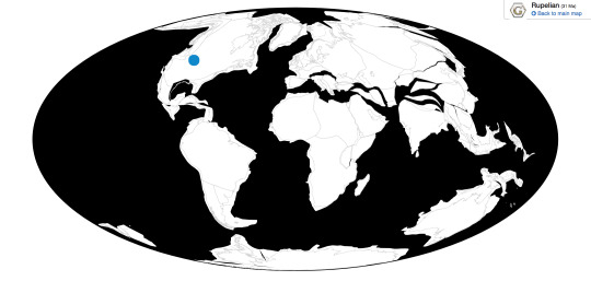
Time and Place: Between 33 and 30 million years ago, in the Rupelian age of the Oligocene of the Paleogene
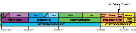

Archaealectrornis is known from the Brule Formation of Nebraska
Physical Description: Archaealectrornis is an ancient chicken relative, about 56 centimeters in length - roughly the same length as a living Mallard, though of course, Archaealectrornis was shaped more like modern currasows and chickens. It was a fairly stout bird, stouter than its close relatives, especially in the wings - indicating it convergently evolved with proper chickens, despite probably being closer to curassows. It would have been round in appearance, and probably ornamented in some way like living chickens.
Diet: It is uncertain what sort of food Archaealectrornis ate, given its skull is not preserved. Given that, it seems likely that it fed on fruits, leaves, and seeds, like many modern curassows - also, potentially, insects.
Behavior: Archaealectrornis probably behaved similarly to modern landfowl, with bobbing heads, carefully placed steps, and extremely clumsy flight. It also probably used display feathers to attract mates. Given it was a smaller animal, it would have been fairly skittish. Beyond that, it’s uncertain how Archaealectornis would have behavied.
Ecosystem: Archaealectrornis lived alongside a variety of animals in the Brule Formation. This was a freshwater lake environment near a volcano, which would bury the creatures very quickly, leading to an extensive number of fossils. It would have been a fairly sandy lake, and thus a large one, but also with extensive mud. There were also a lot of flowering plants in this region. There were many kinds of dinosaurs that lived alongside Archaelectrornis, such as the bird of prey Buteo grangeri, pseudotoothed birds, the large predatory birds Paracrax and Bathornis, and the other curassow relative Palaeonossax. Reptiles such as soft-shelled turtles, snakes, and lizards were extremely common as well. Archaelectrornis also lived with a variety of mammals such as rodents, ruminants, swamp rhinos, rhinos, ruminating hogs, entelodonts, horses, rabbits, shrews, camels, leptictids, false sabre-tooth cats, dogs, bear-dogs, hippo-whales, peccaries, deer relatives, insectivores, and more. Thus, as far as potential predators go, Archaealectrornis would probably have been most nervous around Buteo, paracrax and Bathornis, and of course the variety of cats, dogs, and bear-dogs.
Other: Archaealectrornis was originally thought to be a stem-chicken, but is now thought to be a curassow relative that convergently evolved similarities to chickens.
~ By Meig Dickson
Sources under the cut
Burke, J. J. 1934. New Duchesne River Rodents and a Preliminary Survey of the Adjidaumidae. Annals of Carnegie Museum 23:391-398
Denson, N. M., J. R. Gill. 1965. Uranium-bearing lignite and carbonaceous shale in the southwestern part of the Williston Basin - a regional study, with a section on heavy minerals in Cretaceous and Tertiary rocks associated with uranium occurrences. United States Geological Survey Professional Paper 463:1-75
Hoganson, J. W., G. E. Lammers. 1992. North Dak Geol Surv Misc Ser. 76
Jobling, J. A. 2010. The Helm Dictionary of Scientific Bird Names. Christopher Helm Publishing, A&C Black Publishers Ltd, London.
Lithostratigraphy, Paleontology, and Biochronology of the Chadron, Brule, and Arikaree Formations in North Dakota. NPS.gov.
Mayr, G. 2009. Paleogene Fossil Birds. Springer-Verlag Berlin Heidelberg.
Stevens, K. K. 1995. 27(3):88
#archaealectrornis#archaealectrornis sibleyi#bird#dinosaur#chicken#landfowl#currassow#birds#dinosaurs#paleontology#prehistoric life#prehistory#factfile#palaeoblr#birblr#paleogene#north america#omnivore#terrestrial tuesday#galloanseran#biology#a dinosaur a day#a-dinosaur-a-day#dinosaur of the day#dinosaur-of-the-day#science#nature
92 notes
·
View notes
Last Seen Blogs

mangopatch
Cut the cord

klaviiier-kiiisses
Klaviiier

myshinydex
My Shiny Pokédex.

tatu-music
t.A.T.u. music & Lyrics

martabella
martabella