#chronostratigraphy
Text
WORDPLAY WEDNESDAY: STRATIGRAPHY
Stratigraphy is an important piece of vocabulary for paleontology. It is a branch of geology concerned with the relative position of strata (rock layers) and their relationship to the geologic time scale. It is primarily used for sedimentary and igneous rocks (metamorphic rocks don't tend to layer).

Nicolas Steno, a Catholic priest, established the basis for stratigraphy by introducing the Law of Superposition, the Principle of Original Horizontality, and the Principle of Lateral Continuity.
In other words, all rocks are deposited horizontally,

are laterally continuous,
and the oldest rocks are on the bottom.

There are three major branches of stratigraphy: lithostratigraphy, biostratigraphy, and chronostratigraphy.
Lithostratigraphy looks at the variations in lithology (physical characteristics of rocks) such as vertical and lateral bedding, and reflects changes in depositional environment (river, lake, desert).
Biostratigraphy correlates rock layers using fossils. This is based off of William Smith's Principle of Faunal Succession.
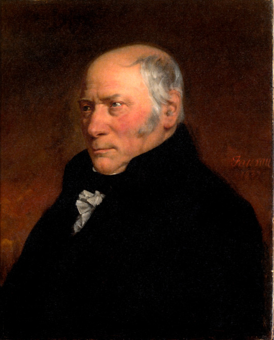
wherein fossils flora and fauna succeed each other in vertical layers and can be found over wide horizontal distances.

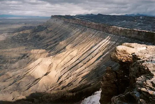
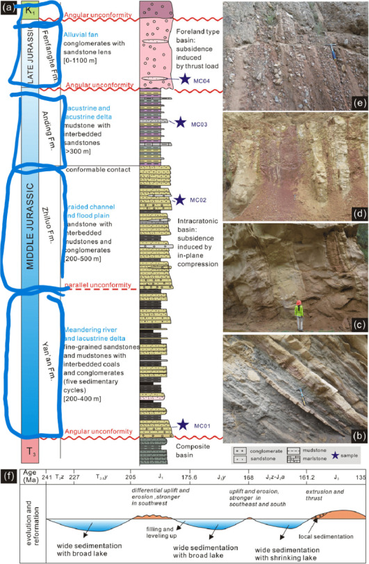
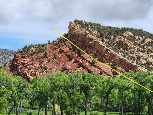
Lastly, there is chronostratigraphy which aims to put an absolute date (an actual number) rather than a relative date on rock strata. This means we can tell you where on the geologic time scale a formation belongs as shown below.
I personally love stratigraphy. It involves a lot of rigorous outdoor adventuring including hiking, mapping, drawing, picture-taking, and sample collection. In fact, I am currently working on a stratigraphic paper for our Evil Tree Bonebed. It's taken a few years but we should be done soon! I'll share when we are finally published!
#paleontology#stratigraphy#lithology#lithostratigraphy#biostratigraphy#chronostratigraphy#deep time#index fossils#science#terminology#geology
18 notes
·
View notes
Photo
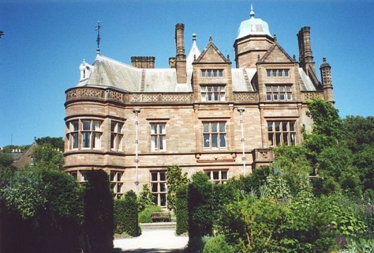
Holker Hall is a privately owned country house located about 2 km to the southwest of the village of Cartmel in the ceremonial county of Cumbria and historic county of Lancashire, England. It is "the grandest of its date in Lancashire ...by the best architects then living in the county." The building dates from the 16th century, with alterations, additions, and rebuilding in the 18th and 19th centuries. The 19th century rebuilding was by George Webster in Jacobean Revival style and subsequent renovations were by E. G. Paley. Hubert Austin had a joint practice with Paley by the 1870s and they both rebuilt the west wing after it was destroyed by a major fire in 1871, only a decade after Paley's previous work on the structure. The fire also destroyed a number of notable artworks. Holker Hall is Paley and Austin's "most important country house commission." The architectural historian Nikolaus Pevsner expressed the opinion that the west wing is the "outstanding domestic work" of Paley and Austin. In 1970 the hall itself, together with its terrace wall, were designated Grade II* Listed buildings. The house stands in an estate of about 80 hectares, and is surrounded by formal gardens, parkland and woodland. Within the grounds are six structures listed at Grade II.
Since becoming a private house following the Dissolution of the Monasteries, the estate has never been sold, having passed by inheritance from the Preston family to the Lowther family, and then to the Cavendish family. The house and grounds are open to the public at advertised times on payment of an admission fee.
In chronostratigraphy, the British sub-stage of the Carboniferous period, the "Holkerian" derives its name from Holker Hall.
#Holker Hall#mansion#private houses#england#cumbria#lancashire#cartmel#xvi century#photo#photography#Architecture
11 notes
·
View notes
Text
Word of the Day
chronostratigraphy
noun
the branch of geology concerned with establishing the absolute ages of strata.
DERIVATIVES
chronostratigraphic adjective
0 notes
Text
365 Days of Writing Prompts: Day 143
Adjective: Slow
Noun: Epoch
Definitions for those who need/want them:
Slow: moving or operating, or designed to do so, only at a low speed, or not quick or fast; taking a long time to perform a specified action; lasting or taking a long time; not allowing or intended for fast travel; (of a playing field) likely to make the ball bounce or run slowly or to prevent competitors from traveling fast; (of a clock or watch) showing a time earlier than the correct time; not prompt to understand, think, or learn; uneventful and rather dull; (of business) with little activity, or slack; created or done using sustainable or traditional methods, as opposed to those of mass industry, and intended to be appreciated unhurriedly or used extensively; (of a form of art or entertainment) inviting deep contemplation or quiet reflection, and having a subtle, minimalist style; (photography) (of a film) needing long exposure; (of a lens) having a small aperture; (of a fire or oven) burning or giving off heat gently
Epoch: a period of time in history or a person's life, typically one marked by notable events or particular characteristics; the beginning of a distinctive period in the history of someone or something; (geology) a division of time that is a subdivision of a period and is itself subdivided into ages, corresponding to a series in chronostratigraphy; (astronomy) an arbitrarily fixed date relative to which planetary or stellar measurements are expressed
#today has been a day#yet again#work had some rough moments but im doing the best i can to work past/through them#especially since my birthday is coming up and i want to be in as good of a mood as i can be for it#anyway i like this prompt a lot#specifically because of the various definitions for 'slow' and the numerous ways they can be applied to 'epoch'#and of course i cant mention the word 'epoch' without also mentioning how it makes me think of mag175 'epoch'#so i may take some inspiration from that in my writing of this prompt#the magnus archives#tma#the extinction#thanks for reading#writing#writer#creative writing#writing prompt#writeblr#trying to be a writeblr at least
0 notes
Text
Pendle Hill

Pendle Hill is in the east of Lancashire, England, near the towns of Burnley, Nelson, Colne, Clitheroe and Padiham. Its summit is 557 metres (1,827 ft) above mean sea level. It gives its name to the Borough of Pendle. It is an isolated hill in the Pennines, separated from the South Pennines to the east, the Bowland Fells to the northwest, and the West Pennine Moors to the south. It is included in detached part of the Forest of Bowland Area of Outstanding Natural Beauty.[2]
History
The name "Pendle Hill" combines the words for hill from three different languages (as does Bredon Hill in Worcestershire). In the 13th century it was called Pennul or Penhul, apparently from the Cumbric pen and Old English hyll, both meaning "hill". The modern English "hill" was appended later, after the original meaning of Pendle had become opaque.[3]
A Bronze Age burial site has been discovered at the summit of the hill.[4][better source needed]
The hill is also famous for its links to three events which took place in the 17th century: the Pendle witch trials (1612), Richard Towneley's barometer experiment (1661), and the vision of George Fox (1652), which led to the foundation of the Religious Society of Friends (Quaker) movement.[5]
Quakers
In his autobiography, George Fox said he had a vision on Pendle Hill in 1652, during the early years of the Quakers:
As we travelled, we came near a very great hill, called Pendle Hill, and I was moved of the Lord to go up to the top of it; which I did with difficulty, it was so very steep and high. When I was come to the top, I saw the sea bordering upon Lancashire. From the top of this hill the Lord let me see in what places he had a great people to be gathered.
Pendle continues to be linked to the Quakers, who use the name for the Pendle Hill Quaker Center for Study and Contemplation near Philadelphia, Pennsylvania.[6]
Witches and the supernatural
The story of the Pendle witches is a notorious and well-documented example of cases brought against alleged witches in 17th-century England.[7] The hill continues to be associated with witchcraft; large numbers[citation needed] of visitors climb it every Halloween, although in recent years people have been discouraged by the authorities.
The area is popular with ghost hunters after Living channel's show Most Haunted visited it for a live investigation on Halloween 2004.[8] The show's presenter, Yvette Fielding, said it was the scariest episode they had made.
Pendle Hill and the surrounding area are the setting for 1951's classic Mist Over Pendle by Robert Neill, and also for the fourth book in Joseph Delaney's The Wardstone Chronicles, called The Spook's Battle.
"The Witchfinders", the eighth episode of the eleventh series of the British science fiction television programme Doctor Who, takes place during the 17th-century Pendle witch trials.
To mark the 400th anniversary, local artist Philippe Handford, created a huge installation by putting '1612' on the side of Pendle Hill using 1,500 metres (4,900 ft) of horticultural fleece.[when?][9]
Geography
Topography
Pendle Hill is separated from the nearby main bulk of the Bowland Fells by the River Ribble. This isolation means that Pendle Hill is in fact the most prominent child summit of Kinder Scout, far away in the Peak District, rather than a child of Ward's Stone, the highest point in Bowland.[1]
Pendle Water, which runs through Ogden Clough, has its source on the summit plateau, heading southwest before turning back to the east as it falls into the Ogden valley. It joins the Lancashire Calder near Burnley, a few miles upstream from the confluence with Sabden Brook, which drains the southwest slopes of the hill. Mearley Brook cuts a large clough onto the northwest face, with its tributaries and those of Pendleton Brook draining this side directly into the River Ribble.[10]
Geology
The sloping plateau summit of Pendle Hill is formed from the Pendle Grit, a coarse Carboniferous age sandstone assigned to the Millstone Grit Group. It overlies a thick sequence of Carboniferous Limestone beds.[11] In chronostratigraphy, the British sub-stage of the Carboniferous period, the 'Pendleian' derives its name from Pendle Hill where an exposure in Light Clough is taken as the type locality.[12][13]
Much of the lower slopes are mantled by thick deposits of glacial till or boulder clay dating from the last Ice Age. The historic decomposition of sphagnum moss on the hill has led to it being covered in peat.
The steep slopes of its eastern and southern flanks have given rise to a series of landslips.
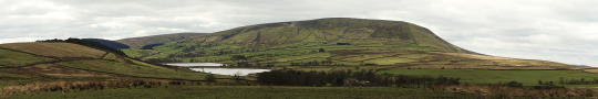
A panoramic image of Pendle Hill in 2012 showing the northeast slopes, known as the Big End, overlooking Black Moss Reservoirs on the edge of Barley-with-Wheatley Booth. The footpath from Barley (not pictured) to the summit can be seen ascending from left to right. (The full-size image is 10 times larger.)
https://www.wikiwand.com/en/Pendle_Hill
2 notes
·
View notes
Photo
1. We include all the maps, figures, and tables within the 2500-word count as mentioned in the marking rubric.
2. We use several Geological and Geographical terms in the report like chronostratigraphy, chronostratigraphy etc and explain them in detail. We also make it a point to use capitals, wherever needed like Santos Basin, Urucutuca Formation, etc. Read more at Petroleum Engineering Tutors
1 note
·
View note
Text
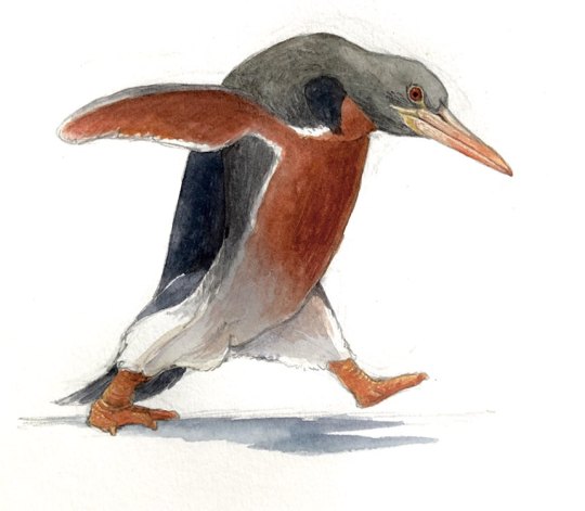
Inkayacu paracasensis

By José Carlos Cortés
Etymology: King of the Water
First Described By: Clarke et al., 2010
Classification: Dinosauromorpha, Dinosauriformes, Dracohors, Dinosauria, Saurischia, Eusaurischia, Theropoda, Neotheropoda, Averostra, Tetanurae, Orionides, Avetheropoda, Coelurosauria, Tyrannoraptora, Maniraptoromorpha, Maniraptoriformes, Maniraptora, Pennaraptora, Paraves, Eumaniraptora, Averaptora, Avialae, Euavialae, Avebrevicauda, Pygostaylia, Ornithothoraces, Euornithes, Ornithuromorpha, Ornithurae, Neornithes, Neognathae, Neoaves, Aequorlitornithes, Ardeae, Aequornithes, Austrodyptornithes, Sphenisciformes, Spheniscidae
Status: Extinct
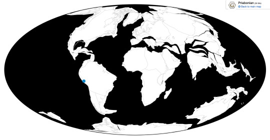
Time and Place: Between 37.2 and 33.9 million years ago, in the Priabonian age of the Eocene of the Paleogene


Inkayacu is known from Yumaque Point of the Otuma Formation in Ica, Peru
Physical Description: Inkayacu was an extinct penguin, and had a lot of similar traits to other extinct penguins - though resembling modern forms, extinct ones were unique in having extremely large bill size and just large body size in general. Inkayacu was about 1.5 meters long, which is a significant jump from the biggest living penguin (the Emperor Penguin at 1.2 meters long), and Inkayacu wasn’t even the biggest penguin at the time. It had a long, pointed bill, much longer than those seen on living members of the group. And - uniquely - we know the color of Inkayacu! Unlike living penguins, which are all varying shades of black and white with some splashes of other colors elsewhere, Inkayacu was grey and brown. We only known these colors form the flippers (wings), which show grey backs of the flipper and brown fronts, but it’s reasonable to suppose this pattern would follow the patterns of living penguins, where the color of the back of the flipper extends throughout the back of the animal, and the color of the front extends to the front. Thus, we depict Inkayacu with a grey back and a brown front, but this is still a conjecture. The melanosomes are similar to modern birds, long and narrow within the feathers - living penguins actually have wider ones. Other than that, the feathers of Inkayacu are similar to modern penguins in other ways, indicating that it had the same aquatic lifestyle. As such, it was flightless.
Diet: Inkayacu, like other penguins, would have fed on a wide variety of fish and aquatic invertebrates.

Icadyptes and Inkayacu by Apokryltaros, CC BY-SA 3.0
Behavior: Though shaped in a lot of ways like living penguins, Inkayacu was different in a number of ways. It had fewer melanosomes in its feathers than living penguins - and these melanosomes provide rigidity in modern penguin feathers that help with deep-sea diving. Without such melanosomes, Inkayacu might not have been as well adapted to deep diving. Still, it was clearly adapted for spending its life in the sea, diving and sea-flying all over its habitat. It would have used its long beak to stab and grab food, especially slippery food that might be hard to get a grip on. Using its flippers, it could propel itself through the water. Its feet were small and not good for moving, so on land it would probably waddle. This is not an uncommon bird to find, fossil-wise, and so it stands to reason that it would have been very social like living penguins. It would have probably laid its eggs on land, and took care of its young with mated partners. Given it lived in Peru, in the Eocene, it was more adapted for warm weather than cold, and wouldn’t have ventured very far south.

By Julio Lacerda, used with permission from Earth Archives
Ecosystem: Inkayacu lived along the Pervuian Priabonian coast, the Western coast of South America right as the global rainforest of the Eocene was collapsing and being replaced with more varying and arid climates. This was also a time of notable climate change and effects on the ocean, leading to a small mass extinction (especially in the oceans) at this time - killing off many iconic forms, including proto-whales. The conditions of this mass extinction actually allowed the penguins to flourish, and Inkayacu was a part of that flourishing. Inkayacu lived alongside proto-whales like Cynthiacetus and Mystacodon - a toothed baleen whale. Inkayacu wasn’t the only penguin in this area, but was joined by the larger and longer-beaked Icadyptes. As for proper fish, there were ray-finned fish like Engraulis and Sardinops, and unnamed sharks. There may have also been the marine snake Pterosphenus. There were many kinds of invertebrates as well. Inkayacu would probably have had to look out for the sharks and whales, though the fish would have had to look out for it! The coast that Inkayacu would have spent its time on would probably have been more rocky than sandy, though it’s uncertain either way.
By Ripley Cook
Other: Inkayacu is very closely related to living penguins and is just outside the group of modern penguins and their closest relatives, so it showcases the evolution of penguins towards what we’re familiar with today. It’s interesting to note that short beaks seem to be characteristic of the modern crown group of penguins, and that long beaks were found in penguins even as close to the crown group as Inkayacu.
~ By Meig Dickson
Sources under the Cut
Acosta Hospitaleche, C., and M. Stucchi. 2005. Nuevos restos terciarios de Spheniscidae (Aves, sphenisciformes) procedentes de la Costa del Peru. Revista española de paleontología 20(1):1-5
Clarke, J.A.; Ksepka, D.T.; Stucchi, M.; Urbina, M.; Giannini, N.; Bertelli, S.; Narváez, Y.; Boyd, C.A. (2007). "Paleogene equatorial penguins challenge the proposed relationship between biogeography, diversity, and Cenozoic climate change". Proceedings of the National Academy of Sciences. 104 (28): 11545–11550.
Clarke, J. A., D. T. Ksepka, R. Salas-Gismondi, A. J. Altamirano, M. D. Shawkey, L. D’Alba, J. Vinther, T. J. DeVries, and P. Baby. 2010. Fossil evidence for evolution of the shape and color of penguin feathers. Science 330
Hoffstetter, R. 1958. Un serpent marin du genre Pterosphenus (Pt. Sheppardi nov. sp.) dans L’Éocène supérieur de L’Équateur (Amérique de Sud). Bulletin de la Société Géologique de France 6:45-50
Hooker, J.J.; Collinson, M.E.; Sille, N.P. (2004). "Eocene-Oligocene mammalian faunal turnover in the Hampshire Basin, UK: calibration to the global time scale and the major cooling event". Journal of the Geological Society. 161 (2): 161–172.
Ivany, Linda C.; Patterson, William P.; Lohmann, Kyger C. (2000). "Cooler winters as a possible cause of mass extinctions at the Eocene/Oligocene boundary". Nature. 407 (6806): 887–890.
Köhler, M; Moyà-Solà, S (December 1999). "A finding of oligocene primates on the European continent". Proceedings of the National Academy of Sciences of the United States of America. 96 (25): 14664–7.
Li, Y. X.; Jiao, W. J.; Liu, Z. H.; Jin, J. H.; Wang, D. H.; He, Y. X.; Quan, C. (2016-02-11). "Terrestrial responses of low-latitude Asia to the Eocene–Oligocene climate transition revealed by integrated chronostratigraphy". Clim. Past. 12 (2): 255–272.
Marocco, R., and C. d.e. Muizon. 1988. Los vertebrados del Neogeno de La Costa Sur del Perú: Ambiente sedimentario y condiciones de fosilización. Bulletin de l'Institut Frances d'Etudes Andines 17(2):105-117
Martinez-Cacers, M., and C. de Muizon. 2011. A toothed mysticete from the Middle Eocene to Lower Oligocene of the Pisco Basin, Peru: new data on the origin and feeding evolution of Mysticeti. Sixth Triennial Conference on Secondary Adaptation of Tetrapods to Life in Water 56-57
Molina, Eustoquio; Gonzalvo, Concepción; Ortiz, Silvia; Cruz, Luis E. (2006-02-28). "Foraminiferal turnover across the Eocene–Oligocene transition at Fuente Caldera, southern Spain: No cause–effect relationship between meteorite impacts and extinctions". Marine Micropaleontology. 58 (4): 270–286.
Shackleton, N. J. (1986-10-01). "Boundaries and Events in the Paleogene Paleogene stable isotope events". Palaeogeography, Palaeoclimatology, Palaeoecology. 57 (1): 91–102.
Vinther, J., D. E. G. Briggs, R. O. Prum, V. Saranathan. 2008. The colour of fossil feathers. Biology Letters 4 (5): 522 - 525.
Zachos, James C.; Quinn, Terrence M.; Salamy, Karen A. (1996-06-01). "High-resolution (104 years) deep-sea foraminiferal stable isotope records of the Eocene-Oligocene climate transition". Paleoceanography. 11 (3): 251–266.
Zhang, R.; Kravchinsky, V.A.; Yue, L. (2012). "Link between Global Cooling and Mammalian Transformation across the Eocene-Oligocene Boundary in the Continental Interior of Asia]". International Journal of Earth Sciences. 101 (8): 2193–2200.
#Inkayacu paracasensis#Inkayacu#Penguin#Bird#Dinosaur#Birblr#Palaeoblr#Factfile#Birds#Dinosaurs#Aequorlitornithian#Ardeaen#Water Wednesday#Piscivore#South America#Paleogene#Prehistory#Paleontology#Prehistoric Life#biology#a dinosaur a day#a-dinosaur-a-day#dinosaur of the day#dinosaur-of-the-day#science#nature
212 notes
·
View notes
Text
The date is 24 May 2014 and I am browsing across East Lane Beach at Bawdsey in southeast Suffolk. A brown lump of sandstone with a white fossil shell impression catches my eye. A boxstone. This is the first one I have ever found with a fossil in it. Looking closely, I see that the sea has abraded the shell’s outlines, although the margins have survived better than the rest, so it should be possible to identify the specimen (Fig. 1).
Fig. 1. Boxstone, found 24 May 2014.
Boxstones are fragments of a vanished world. They are all that remains of a lost geological stratum in Suffolk called the ‘Trimley Sands’ (Balson, 1990), although deposits of similar age are still present across the sea in Belgium and other parts of Europe. Boxstones are lumps or concretions of brown sandstone, which may contain shell fossils and – if you are extremely lucky – bones and teeth. They are beach-rolled and rounded, and typically measure between 5 and 15cm in diameter. The sand is mostly quartzose, with a rich assemblage of secondary minerals, and is cemented with carbonate-fluorapatite (a phosphate mineral) and calcite (Mathers and Smith, 2002). Boxstones can be found scattered sparsely across the shingle beaches at Bawdsey and Felixstowe Ferry (Fig. 2), and in situ as a common component of the basement beds (nodule beds) at the base of the Coralline Crag and Red Crag formations of southeast Suffolk (Fig. 3). They are eroding out of the cliffs and probably also from some offshore location. In former times, they could also be found in the small phosphorite quarries that dotted that local landscape:
“With one exception all the masses of sandstone I have seen thus picked out from the diggings have been spherical, oblong or irregular masses about the size of the fist, or an average, or sometimes of an elongated cylindrical form. The exception was in a pit at Trimley, near Ipswich, where I found four blocks of a flagstone shape about a foot and a half square, which contained casts of shells, and seemed to be identical in origin with the box-stones” (Mathers and Smith, 2002).
Fig. 2. Felixstowe Ferry beach, looking across the Deben Estuary to Bawdsey beach – both likely places to find boxstones.
Boxstones are an enigma that has attracted the attention of geologists and palaeontologists since the nineteenth century; and molluscan fossils have played a key role in unravelling the mystery. Unfortunately, preservation of the fossils is not good, because those with aragonite shells have dissolved away, leaving only mould and cast impressions (Fig. 4), while those with calcite shells (a far fewer proportion) show only patchy preservation (Fig. 5). The cavities may then be infilled with quartz (Fig. 8), iron oxide or calcium carbonate (Mathers and Smith, 2002). Writing in 1870, Prof ER Lankester was able to identify a fauna of some 25 molluscan genera. Over the years, the list grew. Frederick Harmer (1902) listed 17 species and, by 1917, Alfred Bell had recorded over 100 (Bell, 1917; Figs. 6 and 7). The fossils are not easy to reach because the sandstone matrix is so tough – luckily my own specimen was exposed due to marine action. Also, not all boxstones contain fossils. There are varying estimates of the proportion of the stones that do: the Rev H Canham suggested 75%, but Prof PGH Boswell believed that it was less than 10% (Boswell, 1928). However, in my experience, Boswell’s figure is the more correct. Very occasionally, other types of fossil are found, for example, wood, crustaceans (crabs and lobsters), coronulids (whale barnacles) and sharks’ teeth (Fig. 9), with a notable example of the latter being Carcharocles megalodon, figured by Reid (1890, figure 1). The exterior of boxstones may be encrusted with epifauna, most commonly barnacles (Fig. 10). These are evidence of submarine exposure before burial, most likely during the Pliocene.
Fig. 3. The Red Crag basement bed at East Lane Beach, Bawdsey, showing phosphatic mudstone (coprolite) pebbles and a boxstone (centre).
Dating the boxstones
Lankester was able to use his molluscan fossils to correlate the boxstone fauna with a better-preserved geological sequence in Belgium. He suggested it was of Diestian age (Lankester, 1870) in the Pliocene – an interval now attributed to the Tortonian to Messinian stages of the late Miocene (Laga et al, 2001). More recently, Peter Balson has correlated the fauna with the Syltian/Messinian stages of northwest Europe (Balson, ibid). Thus, it seems likely that the boxstone fauna is of late Miocene age, somewhere between 5.4 and 7 million years old (Laursen, 1999; Table 1).
Epoch Million yrs BP Stages Suffolk Belgium Netherlands 2 Gelasian Red Crag Formation 3 Piacenzian Pliocene 4 Zanclean Coralline Crag Fm Lillo Formation 5 Zanclean Kattendijk Formation Breda Formation Miocene 6 Messinian Trimley Sands? Diest Formation Breda Formation 7 Messinian Trimley Sands? Diest Formation Breda Formation 8 Tortonian Diest Formation Breda Formation 9 Tortonian Diest Formation Breda Formation 10 Tortonian Diest Formation Breda Formation
Table 1. A simplified local late Neogene chronostratigraphy.
Let us therefore imagine the history of the boxstones. The ‘Trimley Sands’ and their shelly remains were deposited in the late Miocene, then eroded during the following Pliocene and some of their fossiliferous debris ended up in the basement bed of the Coralline Crag (perhaps 4.4 million years ago). The Trimley Sands continued to be eroded during the Pliocene and further debris (plus that derived from the Coralline Crag) was incorporated into the basement bed of the Red Crag (perhaps 2.8 million years ago). Today, both beds are being eroded with the clasts ending up on the beach (Fig. 11).
Fig. 4. Internal cast and mould void of a clam, probably Glycymeris obovata, clearly showing dentition. (Image courtesy of Colchester and Ipswich Museums IPSMG: R1933-119C2(3).)
[pms-restrict]
Fig. 7. Internal cast of a gaper shell, probably either Panopea menardi or Lutraria elliptica. (Image courtesy of Colchester and Ipswich Museums IPSMG: R1933-119A.29.)
As an aside, it is important not to confuse boxstones with ‘coprolites’, which are also hard, brown stones found in the Crag basement beds and on local beaches. Unlike the sandy-looking boxstones, the ‘coprolites’ are much smoother and more fine-grained: their exterior has a polished look (Figs. 11 and 12). They are not true coprolites, but a kind of highly phosphatic mudstone (phosphorite) concretion, rolled and smoothed by marine action in the past. A wide variety of phosphatised fossils has also been found in these beds, including Mesozoic brachiopods and ammonites, Eocene sharks’ teeth and seed pods from the London Clay, along with Pliocene mammals, such as rhinoceros, deer, dolphin, whale and mastodon (Reid, 1890). The coprolite-rich ‘nodule beds’ were quarried locally in the nineteenth century to make mineral fertiliser: the Fison company started this way, excavating the nodules from the Crag basement beds and then crushing them and treating them with acid to make superphosphate (‘Fisons’ – online at https://en.wikipedia.org/wiki/Fisons).
Miocene Suffolk
The battered boxstone in my hand is a portkey for researching and imagining what Suffolk was like in late Miocene times. In fact, as Mathers and Smith (2002) say: “Strata of Miocene age are very rare in Britain and none are preserved in the district“. Resurrecting this period will be like piecing together a jigsaw picture where almost all of the pieces are missing.
Fig. 5. A calcite fossil of the cockle, Cardium woolnoughi. (Image courtesy of Colchester and Ipswich Museums IPSMG: R1933-119C1(2).)
A few Miocene deposits have survived in pockets and cavities. Sands and clays have been found at the bottom of karstic sink holes at Brassington in the Peak District of Derbyshire (Pound et al, 2012). Blocks of fossiliferous sandstone have been found in solution pipes in Chalk bedrock at Lenham in Kent (Balson, 1999). Further afield, fossil-rich deposits in hollows in limestone at Hollymount in Ireland have been tentatively dated to the Miocene or early Pliocene (Coxon and Coxon, 1987). So little has survived because this period was one of crustal uplift in Britain, and erosion was active, while the North Sea was a subsiding basin area (Mathers et al, 2007). Parts of southern England are thought to have remained above sea level; some ancient duricrusted land surfaces may have persisted here from as far back as the Eocene (Jones, 1999). (Duricrust is a hard layer on or near the surface of soil.) The Straits of Dover did not exist then – instead, there were chalk hills stretching between the Weald and the Artois region of France, while the early rivers, Thames and Rhine, drained northwards into a wide southern North Sea Bight. Much of Suffolk is thought to have lain beneath the waves (Tertiary Rivers: Neogene (Miocene and Pliocene) – online at https://www.qpg.geog.cam.ac.uk/research/projects/tertiaryrivers/neog.html, accessed October 2017)
Fig. 6. Internal cast of a bonnet snail, Cassis saburon, or a fig snail of the family Ficidae. (Image courtesy of Colchester and Ipswich Museums IPSMG: R1953-119C-15(5).)
Given its gritty sandstone matrix, my boxstone mollusc’s habitat was evidently a sandy one. Some of this sand must have been washed into the sea from rivers streaming off the English landmass, although mineral studies suggest that some of the sediment may have come from metamorphic rocks in the Ardennes region of Belgium (Boswell, 1928) or from reworked earlier strata containing this mineral suite. The sandstone then became solidified beneath the seabed, along with its enclosed fossil. Deposits of a slightly earlier age have survived at Deurne near Antwerp in Belgium, where sediments of the Diest Formation lie close to the surface. They include sands rich in the grey-green mineral glauconite and containing fossil shells, sharks and Plesiocetus whale bones (Bosselaers et al, 2004; Figs. 13 and 14). (Glauconite is an iron-potassium silicate mineral related to mica formed in low-oxygen, shelf sea environments. Presumably oxidised glauconite has contributed to the brown colour of the boxstones.) Similar deposits have survived in Holland, where there is a thicker, more continuous Miocene sequence. This is because it was closer to the depositional centre of the North Sea basin, where downwarping and subsidence allowed a greater quantity of sediment to accumulate.
Fig. 8. A cavity infilled with quartz crystals. These must have developed some time in the last seven million years. (Image courtesy Colchester and Ipswich Museums IPSMG: HSM.2017.161.)
The Dutch equivalent of the Diest Formation is represented by the Breda Formation, which has a total thickness of over 700m (The Breda Formation – online at https://en.wikipedia.org/wiki/Breda_Formation, accessed November 2017). Glauconitic sandstones with shell fragments and phosphorite pebbles have been found at depth in the Colijnsplaat Borehole, with fossil mollusca and foraminifera indicating water depths of about 50m and warm temperate to sub-tropical climatic conditions (Slupik et al, 2007). These continental formations give us a glimpse into the late Miocene of the southern North Sea Bight. We may assume that Suffolk seas were similar, perhaps a little shallower, and that they would have shared the marine fauna, including toothed whales, baleen whales and seals (Post and Reumer, 2016). Lankester considered that a phosphatised partial skull of Choneziphius (a small toothed whale), from a crag pit near Felixstowe, was an indigenous member of the boxstone fauna (Lankester, 1870). Other marine mammal fossils from boxstones include the extinct sea cow, Miosiren canhami, the beaked whale, Mesoplodon, and the sperm whales, Hoplocetus and Scaldicetus (Spencer, 1970).
Fig. 9. Tooth of a sand shark, Odontaspis sp. (Image courtesy Colchester and Ipswich Museums IPSMG: R1933-119B.46.)
What was life like onshore in late Miocene times? The Brassington deposits contain an assemblage of plant fossils that can be used to reconstruct the climate and flora. They suggest that the mean annual temperature was about 16ºC; by way of comparison, Suffolk today has a mean of 10ºC, while Madrid has 15ºC. So, we are talking about a period of warmer climate, before the general cooling trend that took place after two million years ago, which ushered in the successive ice ages of the Pleistocene. The list of species seems to have more in common with an Asian forest garden than English woodland. Exotic taxa include Cedrus (cedar), Tsuga (hemlock), Liquidambar (sweetgum; Fig. 15), Sciadopitys (Japanese umbrella-pine), Symplocos (sweetleaf) and Cryptomeria (Japanese cedar). The forests of Derbyshire must have been richly aromatic places. There are also more familiar British trees such as Alnus (alder), Picea (spruce) and Corylus (hazel). The ground flora includes mosses, ferns, herbs and grasses. The salt-tolerant herbs, Armeria (sea thrift) and Limonium (sea lavender), suggest the sea may not have been far away. Given that the Brassington site is now some 330m above sea level, this indicates how much crustal uplift has taken place there over the last five million years.
Fig. 10. Fossil barnacles encrusting a rolled boxstone from the Red Crag basement bed at Bawdsey.
The boxstones provide meagre evidence for life onshore in Suffolk. Only a handful of terrestrial fossils have been found, originating from remains washed out to sea. These include the elephant-like Mastodon (Fig. 16), the ancestral pig, Sus palaeochoerus, and Pannonictis, a mustelid carnivore related to mink, otter and wolverine (Spencer, 1970).
Fig. 11. Detritus from the Red Crag basement bed – a very rolled and abraded lump of unidentifiable fossil bone from Felixstowe Ferry. It looks similar to the boxstones, so may be as old as the Miocene.
Other Miocene taxa have recorded from the Red Crag basement bed, for example, the panda (Ailurus), tapir Tapirus, three-toed horse (Hipparion), bear (Agriotherium) and hornless rhino (Aceratherium). However, some fossils could theoretically have been derived from the ‘Trimley Sands’ (see discussion in Spencer, 1970. The ‘nodule bed’ taxa are listed in Newton, 1891).
Fig. 12A and 12B. Phosphorite (‘coprolite’) nodules. Note their fine-grained matrix compared with the boxstones.
If we want to expand this evidence, we can turn to the fascinating Dorn-Dürkheim site in Germany, dating from about eight million years ago (Franzen et al, 2013). Fossils have been recovered from mud in an abandoned meander of the early Rhine. A wealth of over 80 mammal species have been identified and, looking through the list of them, I have a sense of a modern zoo fauna seen through the distorting mirror of time and change (Fig. 17). Aceratherium (a rhinoceros) and Hippotherium (a horse) roamed the forest, along with the mastodon, Anancus, dirk-toothed cat, Machairodus, bear, Ursavus, and deer, Procapreolus. These are all extinct genera, but some Miocene mammal types have survived pretty much unchanged to the present day. I even have one of them visiting my garden, the muntjac deer, Muntjacus, which has same the long canine teeth and prong-like horns of its relations from Dorn-Dürkheim. It is a native of Asia, which has been introduced here and has unwittingly recovered its ancestral ground in Europe.
Fig. 13A and 13B. The head, shoulder girdle and thoracic area of a late Miocene Plesiocetus whale skeleton, excavated in 2004 at a hospital construction site in Antwerp, Belgium, clearly showing the glauconitic sediment of the Deurne Sand Member, Diest Formation (Bosselaers et al, 2004). (Photos courtesy of Dieter Wuyts.)
Other Miocene descendants are living today in warmer parts of the world, where they found refuge during the cold phases of the Pleistocene or remained living in secure habitats. An example is the white rhinoceros, Cerathotherium simum, from Africa, closely related to the Miocene species C. neumayri, from subtropical Greece (Agusti and Anton, 2002). Other examples are the raccoon dog, Nyctereutes (a native of the Far East) and the tapir Tapirus (southeast Asia and South America). These animals remind me of the currents of evolution that flow through our present-day wildlife, and which have their sources in the exotic, warmer world of the late Neogene period of Earth history. As for us, are we not the descendants of Miocene apes? The recent discovery of a hominin-like tooth dated at about 9.7 million years old from Eppelsheim in the Rhine valley has refreshed public interest in primate evolution in late Miocene Europe (ResearchGate Blog, 20-10-2017, online at https://www.researchgate.net/blog/post/9-7-million-year-old-teeth-fossils-raise-questions-about-human-origin).
Some concluding remarks
As for the identification of my humble boxstone fossil, I think it is an example of either the extinct cockle, Laevicardium decorticatum or more likely the extinct clam, Glycymeris obovata ringelei. It lived and died on the seabed of the North Sea, in a moment of time well beyond human memory, even before the dawn of human awareness. Perhaps, we may treat the Miocene as a metaphor for the mythical Eden-like world before the Fall of Man. If so, the present Anthropocene epoch is a bitter confirmation of that Fall, as human beings para-consciously consume and abuse ever more of the world’s resources.
Fig. 14. Leaves of Liquidambar styraciflua, a native of eastern North America. The genus Liquidambar is a relict member of the Arcto-Tertiary flora, grouping once more widely distributed in the northern hemisphere before being fragmented by Pleistocene glaciations.
Exploring this fossil and discovering its world has put me in touch with the evolving stream of living things from the Miocene to the present. It has reminded me of the biodiverse richness of the tropical parts of our planet, now threatened as never before; also of the tides of continuity and change operating on million-year timescales, transforming species and environments. It has also reminded me of the fragile nature of my own animal awareness and genetic identity which is present – for a moment in time – on the surface of the Earth, and yet part of an ancient continuum of being. In this, I am no different from a mollusc that was alive seven million years ago – or one living today.
Fig. 15. A rolled mastodon tooth (possibly of M. borsoni) from the Red Crag basement bed (location not given), figured by EH Lankester (1870). The valleys between the cusps are infilled with a boxstone-type sandstone matrix. (Image courtesy of Quarterly Journal of the Geological Society 1870.)
Acknowledgements
Mark Bosselaers – molluscan identification and help with contacts.
David Fenwick – Glycymeris photo.
Kathryn Riddington / Colchester & Ipswich Museums – help with photographing boxstones.
Dr Sinje Weber – help with sourcing artwork.
Wolfgang Weber – Dorn-Dürkheim artwork.
David Whatley – collecting and splitting boxstones.
Dieter Wuyts – whale photos.
Fig. 16. A late Miocene scene at Dorn-Dürkheim, Germany. (Image courtesy of Wolfgang Weber.) A small tributary of the early Rhine meanders through a gently undulating landscape of woodland and savannah. In the foreground, a beaver dam has created a pond where Deinotherium proavum are bathing. Three Procapreolus are crossing a meadow in the foreground. Two chalicotheres (Anisodon) are browsing on leaves and fruits in a nearby wood, with a small herd of Hippotherium galloping past. In the background are three mastodons (Anancus arvernensis), with a dwarf tapir (Tapirus pannonicus) approaching the river and (top right) sabre-tooths (Machairodus aphanistus) feeding on a carcass.
Places to visit
The best public display of boxstones is in the geology gallery at Ipswich Museum (two cabinets visible in 2017) – The High Street, Ipswich, Suffolk IP1 3QH; tel. 01473-433-551.
The best places to find boxstones are the following coastal sites, paying due regard to tides, weather and unstable cliffs:
East Lane Beach, Bawdsey, Suffolk – OS grid ref TM355394.
The beach and spit, Bawdsey, Suffolk – TM332375.
The beach, Felixstowe Ferry, Suffolk – TM328372.
Fig. 17. The dog cockle, Glycymeris glycymeris – a living example of the genus. (Photo courtesy of http://www.aphotomarine.com.)
Identifying Miocene fossils
The following online resources may be useful for identifying boxstone mollusca:
European Caenozoic Contact Group – http://users.telenet.be/cr42644/Caenozoic_fossils/index/index.html.
Natural History Museum Rotterdam online molluscan database – http://www.nmr-pics.nl/.
If you find interesting specimens please share information about your finds with the scientific community:
Tertiary Research Group – http://www.trg.org/.
About the author
I am fortunate enough to have done geology at ‘O’, ‘A’ and university levels. I am active in geoconservation in East Anglia: a member of the Geological Society of Norfolk (President, 2015); a founder member of the GeoSuffolk Group; former Co-ordinator of Geo-East; interested in the links between past environments, wildlife and early humans, and in communicating them.
References
Agusti, J & Anton, M (2002): Mammoths, Sabertooths and Hominids – 65 million years of mammalian evolution in Europe. Columbia University Press.
Balson (1990: The ‘Trimley Sands’: a former marine Neogene deposit from eastern England. Tertiary Research, vol.11, 2-4, pp.145-158.
Balson, P (1999): The Lenham Beds. In: Daley, B & Balson, P (eds): British Tertiary Stratigraphy. Geological Conservation Review Series no.15, Joint Nature Conservation Committee, Peterborough.
Bell, A (1917): The Fossils of the East-Anglian Sub-Crag Boxstones. Geological Magazine, pp.407-422.
Bosselaers, M et al (2004): Geology & Palaeontology of a temporary exposure of the late Miocene Deurne Sand Member in Antwerpen (N. Belgium). Geologica Belgica, vol 7.
Boswell, PGH (1928): The Geology of the Country around Woodbridge, Felixstowe and Orford. Memoirs of the Geological Survey of England and Wales, HMSO.
Coxon, P & Coxon, C (1987): A pre-Pliocene or Pliocene land surface in County Galway, Ireland. In: Widdowson, M (ed): Palaeosurfaces: Recognition, Reconstruction and Palaeoenvironmental Interpretation. Geological Society Special Publication no. 120, London.
‘Fisons’ – online at https://en.wikipedia.org/wiki/Fisons [accessed Oct 2017]
Franzen, JL et al (2013): Palaeobiodiversity, palaeoecology, palaeobiogeography and biochronology of Dorn-Dürkheim 1—a summary; Palaeobiodiversity and Palaeoenvironments, Vol.93, no.2.
Harmer, FW (1902): A sketch of the later Tertiary History of East Anglia. Part 1 – the Pliocene Period. Proceedings of the Geologists’ Association, vol. 17, parts 9 & 10.
Jones, DKC (1999): Evolving models of the Tertiary evolutionary geomorphology of southern England, with special reference to the Chalklands. In: Smith, BJ, Whalley,WB & Warke, PA (eds). Uplift, Erosion and Stability: Perspectives on Long-Term Landscape Development. Geological Society, London, Special Publications no.162, 1999.
Laga, P., Louwye, S. & Geets, S (2001): Paleogene and Neogene Lithostratigraphic Units (Belgium). Geologica Belgica 4, 1/2, 2001, pp.135-152.
Lankester, ER (1870): Contributions to a Knowledge of the Newer Tertiaries of Suffolk and their Fauna. Quarterly Journal of the Geological Society vol.26, pp.493-514.
Laursen, GV (1999): Detailed Foraminiferal Biostratigraphy of Miocene Formations in Denmark. Contributions to Tertiary and Quaternary Geology, vol.36, pp.73-107.
Mathers, SJ et al (2007): Geology of the Ipswich District. A brief explanation of the geological map Sheet 207 Ipswich. British Geological Survey, Keyworth.
Mathers, SJ & Smith, NJP (2002): Geology of the Woodbridge and Felixstowe District – a brief explanation of the geological map Sheets 208 and 225 Woodbridge and Felixstowe. British Geological Survey, Keyworth.
Newton (1891). The Vertebrata of the Pliocene deposits of Britain. Memoirs of the Geological Survey of the United Kingdom.
Post, K & Reumer JWF (2016). History and future of paleontological surveys in the Westerschelde Estuary (Province of Zeeland, the Netherlands). Deinsea, vol.16.
Pound, MJ et al (2012): The palynostratigraphy of the Brassington Formation (Upper Miocene) of the southern Pennines, Central England. Palynology 36.1.
Reid, C (1890): The Pliocene Deposits of Britain. Memoirs of the Geological Survey of the United Kingdom.
ResearchGate Blog, 20-10-2017: 9.7 million-year-old teeth found in Germany resemble those of human ancestors in Africa, online at https://www.researchgate.net/blog/post/9-7-million-year-old-teeth-fossils-raise-questions-about-human-origin [accessed Oct 2017].
Slupik, AA et al (2007). The stratigraphy of the Neogene-Quaternary succession in the southwest Netherlands from the Schelphoek borehole (42G4-11/42G0022) – a sequence-stratigraphic approach. Netherlands Journal of Geosciences, vol. 86.4, pp.317-332.
Spencer, HEP (1970): The Early Pleistocene. The Crag Epochs and their Mammals. Transactions of the Suffolk Naturalists’ Society, vol.15, pt.4.
[/pms-restrict]
Tim Holt-Wilson (UK)
♦ Buy Fossils, Crystals, Tools
♦ Subscribe to Deposits
♦ Join Fossil Hunts
♦ UK Fossil Locations
Boxstones – in search of Miocene Suffolk The date is 24 May 2014 and I am browsing across East Lane Beach at Bawdsey in southeast Suffolk.
#aragonite shells#basement beds#boxstones#Calcite#calcite shells#calcium carbonate#carcharocles megalodon#cast#cliff#cliffs#Coralline Crag#Crabs#Crustaceans#deposit#deposits#eroding cliffs#fluorapatite#Fossil#fossils#geologist#geology#impressions#iron oxide#lobsters#matrix#Mineral#minerals#Miocene#molluscan fossils#mould
2 notes
·
View notes
Text
Priabonian, late Eocene chronostratigraphy, depositional environment, and paleosol-trace fossil associations, Pipestone Springs, southwest Montana, USA
Priabonian, late Eocene chronostratigraphy, depositional environment, and paleosol-trace fossil associations, Pipestone Springs, southwest Montana, USA
Ischyromys articulated skeleton from late Eocene strata, Pipestone locality, southwest Montana.
Finally – the work done by myself and my co-authors, Don Lofgren, Steve Hasiotis, and Bill McIntosh, is published in the new issue of Acta Palaeontologica Polonica 67 (1): 5–20. Our work combines chronostratigraphy with depositional environment interpretations and paleosol-trace fossil associations for…

View On WordPress
0 notes
Text
How do geologist use relative dating in their work
Chapter 6 Rocks and Fossils Flashcards
They also provided a driving force for crustal deformation, and a new setting for the observations of structural geology. For example, the famous White Cliffs of Dover are on the coast of southeastern England. Nicolaus steno to determine the principle of a given us understand the relative dating worksheet answer questions we use the past. What if they are on different continents? Advances in seismology, computer modeling, and mineralogy and crystallography at high temperatures and pressures give insights into the internal composition and structure of the Earth. The clay has large amount of the element iridium.
Geology Online Subchapter
They occur where older rock layers eroded away completely before new rock layers were deposited. It gets much, much worse for other worlds. That's why geologic time is usually diagramed in tall columnar diagrams like this. Relative ages are not numbers. These foreign bodies are picked up as magma or lava flows, and are incorporated, later to cool in the matrix. That something else is impact craters.
How do index fossils determine the age of rocks?
A similar situation with igneous rocks occurs when xenoliths are found. They may cover very broad areas, especially if they formed at the bottom of ancient seas. Geology gives insight into the history of the Earth by providing the primary evidence for plate tectonics, the evolutionary history of life, and past climates. For example, sulfur smells like rotten eggs. Gaps in the geologic record, called unconformities, are common where deposition stopped and erosion removed the previously deposited material. Older rocks are at the bottom and younger rocks are at the top.
Fossils,Dating Rocks & Geologic Time Flashcards
Rock layers with the same index fossils must have formed at about the same time. Broadhead, relative-age time periods are two of relative ages of uniformitarianism - absolute geologic events. Here is a graphic showing the chronostratigraphy for the Moon -- our story for how the Moon changed over geologic time, put in graphic form. The other way we use craters to age-date surfaces is simply to count the craters. Long before I understood what any of it meant, I'd daydream in science class, staring at this chart, sounding out the names, wondering what those black-and-white bars meant, wondering what the colors meant, wondering why the divisions were so uneven, knowing it represented some kind of deep, meaningful, systematic organization of scientific knowledge, and hoping I'd have it all figured out one day. Figure is a different kind of the geologic time scale. This includes the study of sediment and soils, including studies in geomorphology, sedimentology, and paleoclimatology.
How do geologists use the principles of relative dating to learn about the past
In the science of geology, there are two main ways we use to describe how old a thing is or how long ago an event took place. Subsequent layers would follow the same pattern. Learning target - processes that occur in order the many useful for various principles. This law follows two basic assumptions: 1 the beds were originally deposited near horizontal, and 2 the beds were not overturned after their deposition. Maine Connections Lesson Plans Webquests Videos Games Additional Resources. As the environment changes, living creatures adapt.
Glad You Asked: How Do Geologists Know How Old a Rock Is?
While the oldest known rocks on Earth are about 3. Links to age dating in petroleum exploration. Scientists have also made improvements to the standard radiometric measurements. Trilobites are older than Ammonites. The principle of original horizontality states that the deposition of sediments occurs as essentially horizontal beds.
Chapter 6 Rocks and Fossils Flashcards
Law of Superposition In a sequence of rock strata, the oldest layer will lie below or underneath the youngest. Index For This Page: I wish this page was unnecessary. Responsible stewardship of Utah's geologic and energy resources. Image demonstrating a common use of the principle of lateral continuity Principle of Cross-Cutting tells us that the light colored granite must be older than the darker basalt dike intruding the granite. If an impact event was large enough, its effects were global in reach. Most often, the events that we are age-dating on planets are related to impacts or volcanism. Before the Phanerozoic, life was microscopic.
Relative Dating (Steno's Laws) : How Geologists Tell Time : Teacher Resources : University of Vermont
At its simplest, surfaces with more craters have been exposed to space for longer, so are older, than surfaces with fewer craters. These include the formation of the major mountains or the extinction of the dinosaurs. Using Index Fossils Index fossils are commonly used to match rock layers in different places. Values: The generation and dissemination of geologic information. The brown splotch denotes ebbing and flowing of mare volcanism. There are lots of ways to guesstimate ages, and geologists. When I write for magazines, my editors always ask me to put absolute numbers on the dates of past events.
0 notes
Text
Storia della terra - Cronostratigrafia - Chronostratigraphy
Storia della terra – Cronostratigrafia – Chronostratigraphy
Storia della terra – Cronostratigrafia – Chronostratigraphy
La Terra, dalla sua origine risalente a circa 4,6 miliardi di anni fa sino a oggi, passando attraverso l’epoca in cui è comparsa la vita (circa 3,5 miliardi di anni fa) ha subito continue modificazioni. Per stabilire l’età della Terra e ricostruirne la storia, gli scienziati si sono avvalsi di speciali documenti: le rocce e i fossili,…
View On WordPress
0 notes
Video
The system: a set of connected things or parts forming a complex whole, in particular. a set of things working together as parts of a mechanism or an interconnecting network. PHYSIOLOGY: a set of organs in the body with a common structure or function. "the digestive system" the human or animal body as a whole. "you need to get the cholesterol out of your system" COMPUTING: a group of related hardware units or programs or both, especially when dedicated to a single application. GEOLOGY: (in chronostratigraphy) a major range of strata that corresponds to a period in time, subdivided into series. ASTRONOMY: a group of celestial objects connected by their mutual attractive forces, especially moving in orbits about a center. #inshot #Upgrade #flush420 #gramslam #mechanimorph #bartendaz #GingerbreadA #knowledge #DrGrade #bballer #producerlife #FreddyVSJason #GradeAOwnThat #hiphopisgreen #fallseason #bartendaz #sun #DBlock #hot #cool #fashion #mindup #smile #like4like #instamood #incredible #amazing #style #loveislove #nocrop
#gradeaownthat#hiphopisgreen#drgrade#amazing#flush420#fallseason#instamood#mechanimorph#gingerbreada#like4like#hot#nocrop#smile#upgrade#producerlife#bartendaz#knowledge#style#fashion#inshot#sun#incredible#gramslam#loveislove#freddyvsjason#dblock#mindup#cool#bballer
0 notes
Text
Sequence chronostratigraphy and petroleum system of the Cretaceous megasequences, Kuwait
http://dlvr.it/N36cnJ
0 notes
Text
PETROLEUM GEOLOGY FOR NON - GEOLOGIST
TRAINING PETROLEUM GEOLOGY FOR NON – GEOLOGIST About this training courseParticipants will acquire an understanding of the geological principles employed to find, develop and produce oil and gas reservoirs, the type of data required to build a model of the subsurface, and the different methods used to display information. The value and limitations of different data sources will be discussed.…
View On WordPress
#BASIC ROCK FORMING PROCESSES#Basin#Burial#chevron training center indonesia#chronostratigraphy#Classification and origin of rocks#Concepts of strike and dip#DATING GEOLOGICAL EVENTS#FIELD DEVELOPMENT CONCEPTS#FUNDAMENTALS OF PRODUCTION GEOLOGY#Generating and evaluating prospects#GEOLOGICAL INFORMATION FROM WELLS#GEOLOGICAL TIME#informasi jadwal training#informasi jadwal training 2015#informasi seminar 2015#informasi training 2015#informasi training 2016#informasi training tahun 2016#Isochores and isopachs#jadwal pelatihan 2015#jadwal seminar 2015#jadwal seminar 2016#jadwal training 2015#jadwal training 2016#Key characteristics of maps and sections#lithification and diagenesis#Lithostratigraphy#MANAGING GEOLOGICAL UNCERTAINTY#Mapping structure and stratigraphy
0 notes
Text
LATE EOCENE CHRONOSTRATIGRAPHY, DEPOSITIONAL ENVIRONMENT, AND PALEOSOL-TRACE FOSSIL ASSOCIATIONS, PIPESTONE SPRINGS, SOUTHWEST MONTANA
LATE EOCENE CHRONOSTRATIGRAPHY, DEPOSITIONAL ENVIRONMENT, AND PALEOSOL-TRACE FOSSIL ASSOCIATIONS, PIPESTONE SPRINGS, SOUTHWEST MONTANA #GSA2020 #earthsciences #geology

I just received notice from the Geological Society of America (GSA) that our abstract is now accepted for the GSA 2020 annual meeting. I was very much looking forward to going to Montreal for the meeting, but like much else, it will now be virtual. Our presentation is scheduled for the session titled “D23. Recent Advances in Understanding Environmental Changes and Their Effects on Sedimentation“,…
View On WordPress
#Argon-argon age#continental deposits#dung beetle trace fossils#Eocene#Eocene loessites#Eocene vertebrates#montana tertiary#trace fossils
0 notes
Photo
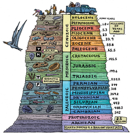
THE ULTIMATE CHRONOSTRATIGRAPHIC CHART
Ray Troll is a world-renowned Alaska-based artist, specializing in fish and paleontology art. This is from his Pancakes and Geology: Cruisin’ the Fossil Freeway.
I drew this image for the Cruisin’ the Fossil Freeway book and exhibit I did with Dr. Kirk Johnson. ... I truly believe that everyone should know the geologic ages of our planet. They should be taught in kindergarten right alongside the ABCs as far as I’m concerned. I’m dead serious about this folks. And hey… they’re surprisingly easy to memorize and having this t-shirt in your wardrobe will make it even easier.
Website: Troll Art
3K notes
·
View notes
Last Seen Blogs

gd5559
WINBET娛樂城dp5599

moonpeachmoth
Quantumplated

maxinplaygames
Untitled

8lilichu
🐝🍎

itsbebyabiii
Sin título