#seismic subduction
Text
sorry your boyfriend got subducted. yeah he’s reintegrating with the mantle and sinking down to the core mantle boundary where he’ll heterogenize and be immediately overlayed by more subducted slab material. yeah he’s completely unrecognizable from when he was on the surface and only detectable by slight differences in seismic wave velocity. sorry :/
1K notes
·
View notes
Text
Under the oceans
Have you ever wondered what exactly lies at the bottom of the ocean? Or, well, under the bottom of the ocean.
The oceanic crust is relatively thin, only between 2 and 10 km at most, with a global average of 7 km. Its density is between 2.8 and 3.2 g/cm^3 and it is theorized that it cannot be older than 250 millions of years, as oceanic ridges continuously form new crust, while the earth "reclaims" parts of it through subduction.
What is more interesting to me though, is what is actually inside of it.
The "Ophiolitic Sequence" is a reoccurring series of rock formations that can be consistently found through the oceanic crust. As opposed to its continental counterpart, the oceanic crust is relatively predictable from what is known, and usually the same formations can be found in the same order from surface to mantle.
Keep in mind that all of these formations aren't always found under the oceanic crust, in some areas some of them may be missing.
This is a very idealized rendition of what the ophiolitic sequence might look like:
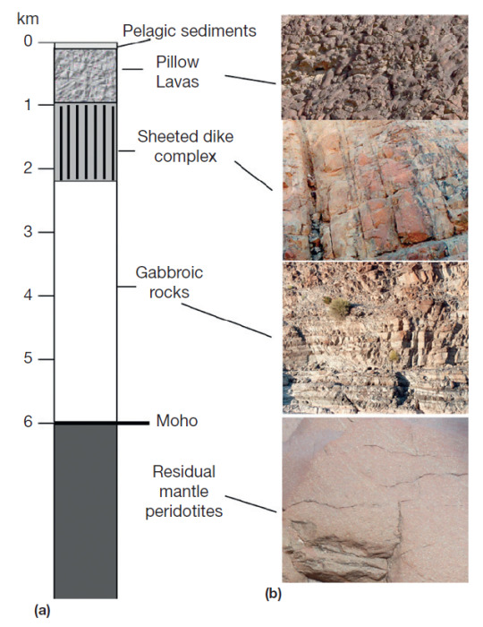
From top to bottom we have:
Pelagic sediments: at the deepest parts of the ocean, this means mostly clay sediments and silicates. Rarely you can find limestone sediments in the ocean, especially at significant depths.
Pillow lavas: the most superficial ignenous formations, formed by lava emerging from the oceanic ridges. They care called this way because when the lava emerges, it comes into contact with water - water applies a hydrostatic pressure that forced the lava to solidify in a rounded shape, similar to the one of a pillow.
Basaltic dykes/dikes: dykes are vertical or semi-vertical magmatic intrusions, these are made of basalt which means they are particularly rich in plagioclase feldspar minerals, specifically rich in calcium.
Gabbroic rocks: gabbro is an intrusive rock, it is pretty much the intrusive counterpart to basalt, as it is also rich in high-Ca plagioclase feldspar minerals.
Moho: "Moho" is not a rock formation, but a geologic and chemical discontinuity that separates crust and mantle, the full name of the discontinuity is "Mohorovičić discontinuity", but most people refer to it as just Moho. It's definied by a significant change in the velocity of seismic waves that pass through it.
Peridotites: the top of the mantle is made up mainly by dunites and peridotites, which are both "ultramaphic rocks", as in rocks that are particularly rich in magnesium and iron. dunites are significantly rich in olivine minerals, while the term "peridotite" is used to refer to ultramaphic rocks that have both olivine and pyroxen minerals in relatively similar ratios. (There is honestly an entire essay that could be written about these rocks alone but maybe in a different post, they are my favorite rocks lol).
I hope this post was informative and interesting to read, if you have questions please don't hesitate sending asks to my inbox!
87 notes
·
View notes
Text
Remembering March 11, 2011
On March 11, 2011, a magnitude (Mw) 9.1 earthquake struck off the northeast coast of Honshu on the Japan Trench. A tsunami that was generated by the earthquake arrived at the coast within 30 minutes, overtopping seawalls and disabling three nuclear reactors within days. The 2011 Tohoku Earthquake and Tsunami event, often referred to as the Great East Japan earthquake and tsunami, resulted in over 18,000 dead, including several thousand victims who were never recovered.
The deadly earthquake was the largest magnitude ever recorded in Japan and the third-largest in the world since 1900.
How It Happened
The 2011 event resulted from thrust faulting on the subduction zone plate boundary between the Pacific and North America plates, according to the U.S. Geological Survey.
This region has a high rate of seismic activity, with the potential to generate tsunamis. Past earthquakes that generated tsunamis in the region have included the deadly events of 1611, 1896, and 1933.
The March 11, 2011 earthquake generated a tsunami with a maximum wave height of almost 40 meters (130 feet) in the Iwate Prefecture. Researchers also determined that a 2,000-kilometer (1,242-mile) stretch of Japan’s Pacific coast was impacted by the tsunami.
Following the earthquake, a tsunami disabled the power supply and cooling of three Fukushima Daiichi reactors, causing a significant nuclear accident. All three nuclear cores largely melted in the first three days.
As of December 2020, the Japan National Police Agency reported 15,899 deaths, 2,527 missing and presumed deaths, and 6,157 injuries for the Great East Japan event.
High Costs
In Japan, the event resulted in the total destruction of more than 123,000 houses and damage to almost a million more. Ninety-eight percent of the damage was attributed to the tsunami. The costs resulting from the earthquake and tsunami in Japan alone were estimated at $220 billion USD. The damage makes the 2011 Great East Japan earthquake and tsunami the most expensive natural disaster in history.
Although the majority of the tsunami’s impact was in Japan, the event was truly global. The tsunami was observed at coastal sea level gauges in over 25 Pacific Rim countries, in Antarctica, and on the west coast of the Atlantic Ocean in Brazil.
The tsunami caused $31 million USD damage in Hawaii and $100 million USD in damages and recovery to marine facilities in California. Additionally, damage was reported in French Polynesia, Galapagos Islands, Peru, and Chile.
Fortunately, the loss of life outside of Japan was minimal (one death in Indonesia and one death in California) due to the Pacific Tsunami Warning System and its connections to national-level warning and evacuation systems.
Read more
11 notes
·
View notes
Text
THESE MOUNTAINS SHOULD NOT EXIST
a rant/essay about dreamland's topography

disclaimer: i am a second year ENVS student and may get some details wrong. i don't really feel like sending this to my advisor (the local geologist) to proofread, so it'll have to do. i think she has more important things to do right now than read my kirby rant
to begin, we have to establish some basic rules about geology:
how do mountains form?
mountains come to be in a few ways: shifting plates and hot spots. hot spots are technically also to do with shifting plates, but we'll get to that later. let's talk about the plates first.
there are two kinds of tectonic plates: continental and oceanic. ocean plates are denser than continental plates, which means when an ocean and continental plate converge, the ocean plate will subduct under the continental plate. when two continental plates converge, because they are of similar density, they will collide. this process creates mountains.
mountains created by converging continental plates can be seen, for example, with the Himalayas. in this case, the mountains were formed by the Indian plate pushing up into the Eurasian plate. this method is off the table for dreamland because it is shown to be a peninsula (or at least a thin strip of land) surrounded by water.
ocean-continental convergence also creates mountains, but in a different fashion. this is the more relevant method because dreamland also has a volcano, an active one at that.
when ocean plates subduct under the land, they are forced down into the earth until they reach a melting point. sometimes this newly formed magma travels back to the surface, creating a hot spot. if this magma breaches the surface, it forms a volcano (that eventually cools into a mountain). this method can be seen in the Cascade mountains and the Andes.

the volcano/mountain's proximity to the coast depends on how steep the ocean plate's descent is. if we take a look at how close dreamland's mountains are to the shore...

...the ocean plate would have to be hitting its melting point almost immediately after subducting. forgive me for thinking this is unrealistic.
however, the inclusion of a volcano in this range is realistic! an O-C convergence would create a volcano like this. its portrayal within the show isn't really correct, but that's a post for a different day.
how this could potentially happen
not all hope is lost for the ocean-bordering mountain range, sort of. there are a few things that could have happened in popstar's history to cause something like this.
firstly, we should look at the Appalachian mountains. how did they get there? the North American plate is bordered on its east side by a mid-ocean ridge, where new crust is being created.
the Appalachians came to be around the time Pangea was coming together--the collision of the North American and African plates created the mountain range, and over time Pangea split apart, forcing the mountains away.
any map of tectonic plates will reveal a large split through the Atlantic ocean--this is a divergent boundary, where plates are being pushed apart in favor of creating new lithosphere (crust/upper mantle).
so, with all this in mind, there are a few things it could mean for our mountain range:
dreamland is actually an island, and we don't know because the overhead view doesn't show it
this would mean hot spots are relevant again: if a plate moves over a hot spot, magma can form into islands, especially volcanic ones. this is how Hawaii was formed, and why it is prone to volcanic activity. given that dreamland is an island, this would explain the presence of mountains. Hawaii's tallest peaks are still inland rather than right on the coast, but it's close enough.
2. a new fault/divergent boundary formed between dreamland's mountains and the opposing plate that created them
new faults aren't uncommon, though they don't always succeed. the New Madrid Seismic Zone, for example, made a small break in the American Midwest, but didn't get much farther than that. a successful fault or new divergent boundary could potentially push dreamland's mountains away from their neighboring plate. this is more like what happened to the Appalachians--though they're pretty far inland, so take that as you will. the new boundary would have to form quite close to the mountain range for them to be right on the shore like this.
3. the water has eroded away the land leading up to the mountains
now this isn't really one i have any backup for, i just wanted to throw it in because it came to mind. while it's possible for the ocean to have greatly eroded the land if it's been here for a long time, the mountains would still have to be very close to the shore to end up where they are. dreamland's proximity to the ocean could imply it has a delta at the end of the peninsula, and maybe one of the routes is along the mountains so the channel eats away at the shore for a while...who knows. but this one doesn't feel too realistic, either.
conclusion
as far as i'm aware, it isn't completely impossible for these mountains to exist, but they aren't exactly realistic, either. their proximity to the shore leaves too many questions that are hard to answer without any information about popstar's history and plate tectonics. most likely, dreamland is on an island, and was created as its plate moved over a hot spot. the existence of an active volcano implies that it is still sitting over this hot spot, and will eventually move away from it.
i must really miss my geology class if this is what i'm doing with my spare time. thank you for reading.
#kirby#kirby right back at ya#rhyn rambles#long post#i'm taking hydrology next term which means i might end up being annoying about something else soon#at the very least the river system looks pretty realistic#rivers are harder to mess up than mountains#i'll complain about the volcano if anyone's interested#i have some things to say that include comparing it to dante's peak
16 notes
·
View notes
Text
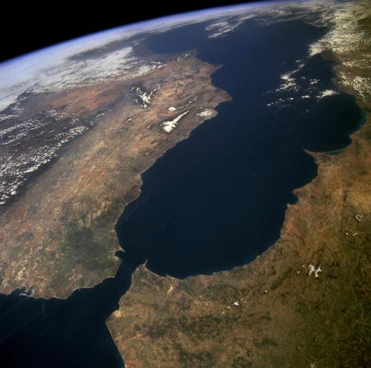
How do oceans start to close? New study suggests the Atlantic may ‘soon’ enter its declining phase
A new study, resorting to computational models, predicts that a subduction zone currently below the Gibraltar Strait will propagate further inside the Atlantic and contribute to forming an Atlantic subduction system – an Atlantic ring of fire. This will happen ‘soon’ in geological terms - in approximately 20 million years.
Oceans seem eternal to our lifespan, but they are not here for long: they are born, grow and one day close. This process, which takes a few hundred million years, is called Wilson Cycle. The Atlantic, for example, was born when Pangea broke up, around 180 million years ago, and will one day close. And the Mediterranean is what remains from a big ocean – the Tethys– that once existed between Africa and Eurasia.
For an ocean like the Atlantic to stop growing and start closing, new subduction zones – places where one tectonic plate sinks below another – have to form. But subduction zones are hard to form, as it requires plates to break and bend, and plates are very strong. A way out of this “paradox” is to consider that subduction zones can migrate from a dying ocean in which they already exist – the Mediterranean – into pristine oceans – such as the Atlantic. This process was dubbed subduction invasion.
This study shows for the first time how such a direct invasion can happen. The computational, gravity-driven 3-D model predicts that a subduction zone currently below the Gibraltar Strait will propagate further inside the Atlantic and contribute to forming an Atlantic subduction system – an Atlantic ring of fire, in an analogy to the already existing structure in the Pacific. This will happen ‘soon’ in geological terms – but not before approximately 20 million years.
“Subduction invasion is inherently a three-dimensional process that requires advanced modelling tools and supercomputers that were not available a few years ago. We can now simulate the formation of the Gibraltar Arc with great detail and also how it may evolve in the deep future” explains João Duarte, first author, researcher at Instituto Dom Luiz, at Faculty of Sciences of the University of Lisbon (Ciências ULisboa) (Portugal).
This study sheds a new light on the Gibraltar subduction zone, as few authors considered it to be still active, because it has significantly slowed down in the past million years. According to these results, its slow phase will last for another 20 million years and, after that, will invade the Atlantic Ocean and accelerate. That will be the beginning of the recycling of crust on the eastern side of the Atlantic, and might be the start of the Atlantic itself beginning to close.
“There are two other subduction zones on the other side of the Atlantic – the Lesser Antilles, in the Caribbean, and the Scotia Arc, near Antarctica. However, these subduction zones invaded the Atlantic several million years ago. Studying Gibraltar is an invaluable opportunity because it allows observing the process in its early stages when it is just happening”, adds João Duarte.
Broadly, this study shows that subduction invasion is likely a common mechanism of subduction initiation in Atlantic-type oceans, and thus plays a fundamental role in the geological evolution of our planet.
The finding that the Gibraltar subduction is still currently active has also important implications for seismic activity in the area. Subduction zones are known for producing the strongest earthquakes on Earth. Events such as the 1755 Great Lisbon Earthquake are a threat and require preparedness.
TOP IMAGE....The Strait of Gibraltar provides a natural physical barrier between the countries of Spain (north) and Morocco (south). In geologic terms, the 10-mile (16-kilometer) strait that separates the two countries, as well as Europe and Africa, is located where the two major tectonic plates—the Eurasian Plate and the African Plate—collide. Credit NASA, Public domain, via Wikimedia Commons
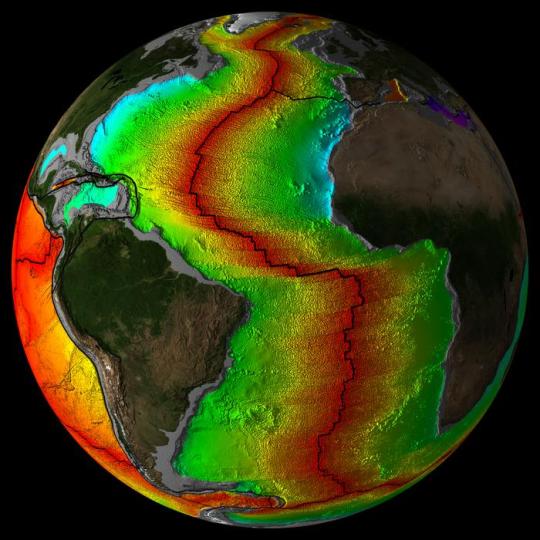
LOWER IMAGE.... Atlantic Ocean Crustal Age Image with Plates Credit Mr. Elliot Lim, CIRES & NOAA/NCEI
7 notes
·
View notes
Text

The 1946 Aleutian Islands earthquake occurred near the Aleutian Islands, Alaska on April 1, 1946. The shock measured (Mw) 8.6, Mt 9.3 or (Ms) 7.4. It had a maximum Mercalli intensity of VI (Strong).[3][4] It resulted in 165–173 casualties and over US $26 million in damage. The seafloor along the fault was elevated, triggering a Pacific-wide tsunami with multiple destructive waves at heights ranging from 45–138 ft (14–42 m). The tsunami obliterated the Scotch Cap Lighthouse on Unimak Island, Alaska among others, and killed all five lighthouse keepers. Despite the destruction to the Aleutian Island Unimak, the tsunami had almost an imperceptible effect on the Alaskan mainland.[5]
Tectonic setting
Map showing the tectonics and seismicity of Alaska
The Aleutian Islands are a group of 14 large and 55 smaller volcanic islands situated between mainland Alaska and Kamchatka.[6] They are situated along the Aleutian Trench as they were formed by the active subduction of the oceanic Pacific plate underneath the continental crust of the North American plate.[7] The western portion of the trench becomes more and more oblique until near the Commander Islands where faulting becomes nearly exclusively strike-slip and causes earthquakes such as the 2017 Komandorski Islands earthquake.[8] The trench ends where the Kuril-Kamchatka Trench begins in the west.[8] In the east, the trench extends for a couple thousand miles before reaching the transition zone near Yakataga responsible for creating earthquakes such as the 1899 Yakutat Bay earthquakes.[9] The collision totally ends slightly further east, where the Queen Charlotte Fault becomes the dominant fault of the tectonic regime.[9] This specific area of the Aleutian Islands is thought to have ruptured in the 1585 Aleutian Islands earthquake.[10]
#moid moment#moids#ywnbaw#radfem#terfblr#terf#terfs please interact#radblr#radical feminists do touch#radical feminist#terfs please touch
2 notes
·
View notes
Link
The linkage between Cascadia subduction zone and the San Andreas Fault is partially outlined in this paper.
4 notes
·
View notes
Note
"The Ring of Fire, also referred to as the Circum-Pacific Belt, is a path along the Pacific Ocean characterized by active volcanoes and frequent earthquakes. Its length is approximately 40,000 kilometers (24,900 miles). It traces boundaries between several tectonic plates—including the Pacific, Juan de Fuca, Cocos, Indian-Australian, Nazca, North American, and Philippine Plates.
Seventy-five percent of Earth’s volcanoes—more than 450 volcanoes—are located along the Ring of Fire. Ninety percent of Earth’s earthquakes occur along its path, including the planet’s most violent and dramatic seismic events.
The abundance of volcanoes and earthquakes along the Ring of Fire is caused by the amount of movement of tectonic plates in the area. Along much of the Ring of Fire, plates overlap at convergent boundaries called subduction zones. That is, the plate that is underneath is pushed down, or subducted, by the plate above. As rock is subducted, it melts and becomes magma. The abundance of magma so near to Earth’s surface gives rise to conditions ripe for volcanic activity. A significant exception is the border between the Pacific and North American Plates. This stretch of the Ring of Fire is a transform boundary, where plates move sideways past one another. This type of boundary generates a large number of earthquakes as tension in Earth’s crust builds up and is released." -Ring of Fire national geographic
In lament terms they going to cause a lot of volcanos to go boom at once.
Would've preferred if you just gave me that last sentence. Also what the fuck.
2 notes
·
View notes
Text
We Know Where The Next Big Earthquakes Will Happen — But Not When
Scientists Have Drastically Improved Our Understanding of Seismic Events. Here are Eight Things to Know.
— By Umair Irfan | April 5, 2024

A building lurches in Taiwan after a Magnitude 7.4 Earthquake Rocked the Island. Sam Yeh/AFP Via Getty Images
Earthquakes Can Strike When and Where We Least Expect Them — as residents in the New York City and New Jersey area discovered on Friday morning, when an estimated magnitude 4.8 quake hit at 10:23 am Eastern time.
The quake’s epicenter was in Lebanon, New Jersey, some 50 miles west of Manhattan, though shaking was reportedly felt as far south as Philadelphia and as far north as Boston. As of late Friday morning, there were no reports of serious damage.
Earthquakes on the East Coast are rare, but not unheard of. On August 23, 2011, a magnitude 5.8 quake struck nearly Mineral, Virginia, causing an estimated $200 to $300 million in damages. That quake occurred in the Central Virginia Seismic Zone.
In part because seismic waves can travel further in East Coast sediment than along the much more seismically-active West Coast, and because the region is so densely populated, scientists at the US Geological Survey estimated that the 2011 quake was likely felt by more people than any other quake in North American history.
Around the world, quakes remain a potent, deadly threat. The largest earthquakes in nearly 25 years rocked Taiwan on Wednesday morning, killing at least nine people and injuring hundreds more. The magnitude 7.4 quake led to a series of aftershocks, the largest of which reached magnitude 6.4. A series of earthquakes reaching magnitude 6.3 struck Afghanistan last year, leading to more than 2,400 deaths. A magnitude 6.8 earthquake rocked Morocco last September, the largest earthquake to hit the country in at least 120 years. Officials reported that it killed more than 2,900 people.
The Mediterranean region is also seismically active, according to the US Geological Survey, though such strong earthquakes are rare in North Africa. Quakes are more common in places like Turkey, where two major fault lines cross and trigger shocks on a regular basis. A huge magnitude 7.8 earthquake rattled across Turkey and Syria in 2023 and another quake with a magnitude of 7.5 rocked the region a few hours later. The quakes killed more than 50,000 people and toppled more than 5,600 buildings in the region.
While scientists have drastically improved their understanding of where earthquakes are likely to occur, forecasting when one will occur is still impractical. The rumbling earth can easily catch people off-guard, worsening the ensuing death and destruction.
In light of the recent disasters, here’s a refresher on earthquakes, along with some of the latest science on measuring and predicting them.
1) The Basics On What Causes Earthquakes
An earthquake occurs when massive blocks of the earth’s crust suddenly move past each other. These blocks, called tectonic plates, lie on top of the earth’s mantle, a layer that behaves like a very slow-moving liquid over millions of years.
That means tectonic plates jostle each other over time. They can also slide on top of each other, a phenomenon called subduction. The places on the planet where one plate meets another are the most prone to earthquakes. The specific surfaces where parcels of earth slip past each other are called faults. As plates move, pressure builds up across their boundaries, while friction holds them in place. When the former overwhelms the latter, the earth shakes as the pent-up energy dissipates.
Scientists understand these kinds of earthquakes well, which include those stemming from the San Andreas Fault in California and the East Anatolian Fault in Turkey. However, earthquakes can also occur within tectonic plates, as pressure along their edges cause deformations in the middle. These risks are harder to detect and measure.
“Our understanding of these within-plate earthquakes is not as good,” said Stanford University geophysics professor Greg Beroza. An earthquake within a tectonic plate has fewer telltale signs than those that occur at fault lines, he added.
2) The Richter Scale Isn’t The Only Measurement Game in Town Anymore
The Richter scale, developed by Charles Richter in 1935 to measure quakes in Southern California, has fallen out of fashion.
It uses a logarithmic scale, rather than a linear scale, to account for the fact that there is such a huge difference between the tiniest tremors and tower-toppling temblors. On a logarithmic scale, a magnitude 7 earthquake is 10 times more intense than a magnitude 6 and 100 times more intense than a magnitude 5.
The Richter scale is actually measuring the peak amplitude of seismic waves, making it an indirect estimate of the earthquake itself. So if an earthquake is like a rock dropped in a pond, the Richter scale is measuring the height of the largest wave, not the size of the rock nor the extent of the ripples.
And in the case of an earthquake, the ripples aren’t traveling through a homogenous medium like water, but through solid rock that comes in different shapes, sizes, densities, and arrangements. Solid rock also supports multiple kinds of waves. (Some geologic structures can dampen big earthquakes while others can amplify lesser tremors.)
While Richter’s scale, calibrated to Southern California, was useful to compare earthquakes at the time, it provides an incomplete picture of risks and loses accuracy for stronger events. It also misses some of the nuances of other earthquake-prone regions in the world, and it isn’t all that useful for people trying to build structures to withstand them.
“We can’t use that in our design calculations,” said Steven McCabe, leader of the earthquake engineering group at the National Institute of Standards and Technology. “We deal in displacements.”
Displacement, or how much the ground actually moves, is one alternative way to describe earthquakes. Another is the moment magnitude scale. It accounts for multiple types of seismic waves, drawing on more precise instruments and better computing to provide a reliable measuring stick to compare seismic events.
When you hear about an earthquake’s magnitude in the news — like Turkey’s recent magnitude 7.8 quake — moment magnitude is usually the scale being used.
But this is still a proxy for the size of the earthquake. And with only indirect measurements, it can take up to a year to decipher the scale of an event, like the 2004 Indian Ocean earthquake, said Marine Denolle, an earthquake researcher at Harvard University.
“We prefer to use peak ground acceleration,” she said. This is a metric that measures how the speed and direction of the ground changes and has proven the most useful for engineers.
So, yes, earthquake scales have gotten a lot more complicated and specific over time. But that’s also helped scientists and engineers take much more precise measurements — which makes a big difference in planning for them.
3) We Can’t Really Anticipate Them All That Well
Predicting earthquakes is a touchy issue for scientists, in part because it has long been a game of con artists and pseudoscientists who claim to be able to forecast earthquakes. (Their declarations have, of course, withered under scrutiny.)
Scientists do have a good sense of where earthquakes could happen. Using historical records and geologic measurements, they can highlight potential seismic hot spots and the kinds of tremors they face. (You can check out the US Geological Survey’s interactive map of fault lines and NOAA’s interactive map of seismic events.)
As for when quakes will hit, that’s still murky.
“Lots of seismologists have worked on that problem for many decades. We’re not predicting earthquakes in the short term,” said Beroza. “That requires us to know all kinds of information we don’t have.”
It’s difficult to figure out when an earthquake will occur, since the forces that cause them happen slowly over a vast area but are dispersed rapidly over a narrow region. What’s amazing is that forces built up across continents over millions of years can hammer cities in minutes.
Forecasting earthquakes would require high-resolution measurements deep underground over the course of decades, if not longer, coupled with sophisticated simulations. And even then, it’s unlikely to yield an hour’s worth of lead time. So there are ultimately too many variables at play and too few tools to analyze them in a meaningful way.
Some research shows that foreshocks can precede a larger earthquake, but it’s difficult to distinguish them from the hundreds of smaller earthquakes that occur on a regular basis.
On shorter time scales, texts and tweets can actually race ahead of seismic waves. In the 2011 Tohoku earthquake in Japan, for example, warnings from near the epicenter reached Tokyo 232 miles away, buying residents about a minute of warning time.
Many countries are now setting up warning systems to harness modern electronic communications to detect tremors and transmit alerts ahead of shaking ground, buying a few precious minutes to seek shelter.
Meanwhile, after a large earthquake, aftershocks often rock the afflicted region. “If we just had a big one, we know there will be smaller ones soon,” Denolle said.
When it comes to prediction, researchers understandably want to make sure they don’t overpromise and underdeliver, especially when thousands of lives and billions of dollars in damages are at stake. But even this caution has had consequences.
In 2012, six Italian scientists were sentenced to six years in prison for accurately saying the risks of a large earthquake in the town of L’Aquila were low after a small cluster of earthquakes struck the region in 2009. Six days after the scientists convened to assess the risk, a large quake struck and killed 309 people. Those convictions were later overturned and the ordeal has become a case study for how scientists convey uncertainty and risk to the public.
4) Sorry, Your Pets Can’t Predict Earthquakes Either
Reports of animals acting strange ahead of earthquakes date back to ancient Greece. But a useful pattern remains elusive. Feathered and furry forecasters emerge every time there’s an earthquake and there’s a cute animal to photograph, but this phenomenon is largely confirmation bias. Animals do weird things (by our standards) all the time and we don’t attach any significance to them until an earthquake happens.
“On any given day, there will be hundreds of pets doing things they’ve never done before and have never done afterward,” Beroza said. Bottom line: Don’t wait for weird animal behavior to signal that an earthquake is coming.
5) Some Earthquakes are Definitely Human-made
The gargantuan expansion of hydraulic fracturing across the United States has left an earthquake epidemic in its wake. It’s not the actual fracturing of shale rock that leads to tremors, but the injection of millions of gallons of wastewater underground.
Scientists say the injected water makes it easier for rocks to slide past each other. “When you inject fluid, you lubricate faults,” Denolle said.
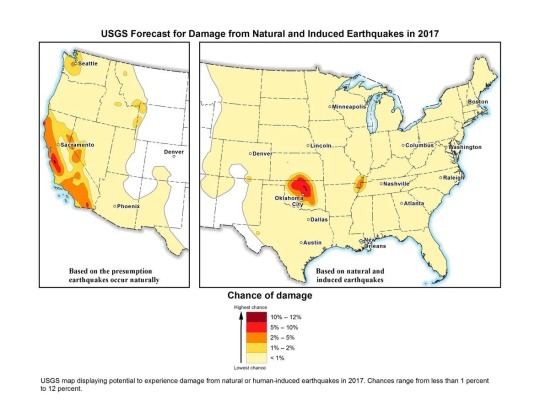
US Geological Survey map of natural and induced earthquake risk in 2017. USGS
The US Geological Survey calls these “induced earthquakes” and reported that in Oklahoma, the number of earthquakes surged to 2,500 in 2014, 4,000 in 2015, and 2,500 in 2016.
“The decline in 2016 may be due in part to injection restrictions implemented by the state officials,” the USGS wrote in a release. “Of the earthquakes last year, 21 were greater than magnitude 4.0 and three were greater than magnitude 5.0.”
This is up from an average of two earthquakes per year of magnitude 2.7 or greater between 1980 and 2000. (“Natural” earthquakes, on the other hand, are not becoming more frequent, according to Beroza.)
Humans are causing earthquakes another way, too: Rapidly drawing water from underground reservoirs has also been shown to cause quakes in cities like Jakarta, Denolle said.
6) Climate Change Could Have a Tiny Effect on Earthquakes
In general, scientists haven’t measured any effect on earthquakes from climate change. But they’re not ruling out the possibility.
As average temperatures rise, massive ice sheets are melting, shifting billions of tons of water from exposed land into the ocean and allowing land masses to rebound. That global rebalancing could have seismic consequences, but signals haven’t emerged yet.
“What might occur is enough ice melts that could unload the crust,” Beroza said, but added there is no evidence for this, nor for which parts of the world will reveal a signal. Denolle agreed that this could be a mechanism, but if there is any impact from climate change on earthquakes, she says she suspects it will be very small.
7) We’ve Gotten Better at Reducing Earthquake Risks and Saving Lives
About 90 percent of the world’s earthquakes occur in the Ring of Fire, the region around the Pacific Ocean running through places like the Philippines, Japan, Alaska, California, Mexico, and Chile. The ring is also home to three-quarters of all active volcanoes.

Most of the planet’s earthquakes occur along the Pacific rim in a region known as the Ring of Fire. Javier Zarracina/Vox
Mexico is an especially interesting case study. The country sits on top of three tectonic plates, making it seismically active. In 1985, an earthquake struck the capital, killing more than 10,000. Denolle noted that the geology of the region makes it so that tremors from nearby areas are channeled toward Mexico City, making any seismic activity a threat.
The Mexican capital is built on the site of the ancient Aztec city of Tenochtitlan, an island in the middle of a lake. The dry lakebed that is now the foundation of the modern metropolis amplifies shaking from earthquakes.
The 1985 earthquake originated closer to the surface, and the seismic waves it produced had a relatively long time between peaks and valleys. This low-frequency vibration sends skyscrapers swaying, according to Denolle. “The recent earthquakes were deeper, so they had a higher frequency,” she said.
The biggest factor in preventing deaths from earthquakes is building codes. Designing buildings to move with the earth while remaining standing can save thousands of lives, but putting them into practice can be expensive and frequently becomes a political issue.
“Ultimately, that information has got to get implemented, and you can pretty much get that implemented in new construction,” McCabe said. “The trickier problem is existing buildings and older stock.”
Earthquake-prone countries know this well: Japan has been aggressive about updating its building codes regularly to withstand earthquakes. The revised standards have in part fueled Japan’s construction boom despite its declining population.
Mexico has also raised standards for new construction. Laws enacted after the 1985 earthquake required builders to account for the soft lakebed soil in the capital and tolerate some degree of movement.
Meanwhile, Iran has gone through several versions of its national building standards for earthquake resilience. And Alaska has been developing earthquake damage mitigation strategies and response plans for years.
But codes are not always enforced, and the new rules only apply to new buildings. A school that collapsed in a 2017 Mexico City earthquake apparently was an older building that was not earthquake-resistant. And because the more recent earthquakes in Mexico shook the ground in a different way, even some of the buildings that survived the 1985 earthquake collapsed after tremors in 2017.
In countries like Iran, there is a wide gulf between how buildings are constructed in cities versus the countryside. More than a quarter of the country’s population lives in rural areas, where homes are built using traditional materials like mud bricks and stone rather than reinforced concrete and steel. This is a big part of why casualties are so high when earthquakes strike remote parts of the country.
The biggest risks fall to countries that don’t have a major earthquake in living memory and therefore haven’t prepared for them, or don’t have the resources to do so. A lack of a unified building code led to many of the more than 150,000 deaths in Haiti stemming from the 2010 magnitude 7.0 earthquake.
8) The Big One Really is Coming to the United States (Someday)
The really big one you keep hearing about is real.
The New Yorker won a Pulitzer Prize in 2015 for its reporting on the potential for a massive earthquake that would rock the Pacific Northwest — “the worst natural disaster in the history of North America,” which would impact 7 million people and span a region covering 140,000 square miles.
The potential quake could reach a magnitude between 8.7 and 9.2, bigger than the largest expected earthquake from the San Andreas Fault, which scientists expect to top out at magnitude 8.2.
Large earthquakes are also in store for Japan, New Zealand, and other parts of the Ring of Fire. We don’t know when these earthquakes will rock us; we just have a rough estimate of the average time between them, which changes from region to region.
“In the business, we’ve been talking about that [Pacific Northwest] scenario for decades,” Beroza said. “I wouldn’t say we’re overdue, but it could happen at any time.”
“It is a threat,” echoed Denolle. “We forget about this threat because we have not had an earthquake there for a while.” “A while” means more than 300 years.
So while California has long been steeling itself for big earthquakes with building codes and disaster planning, the Pacific Northwest may be caught off guard, though the author of the New Yorker piece, Kathryn Schulz, helpfully provided a guide to prepare.
— Umair Irfan is a correspondent at Vox writing about climate change, Covid-19, and energy policy. Irfan is also a regular contributor to the radio program Science Friday. Prior to Vox, he was a reporter for ClimateWire at E&E News.
0 notes
Text
The 2004 Sunda Megathrust Earthquake: Unleashing a Geological Giant
The Sunda Megathrust is an extensive fault line, spanning over 5,500 kilometers, marking the boundary where the Indo-Australian Plate subducts beneath the Eurasian Plate. This fault is notorious for generating some of the most powerful earthquakes in recorded history, including the catastrophic 9.3-magnitude quake that struck off the coast of Sumatra, Indonesia, on December 26, 2004.
A closer examination of the Sunda Megathrust reveals a long period of quiescence, lasting around a millennium, before it unleashed its fury across a 1,600-kilometer section of the fault. The resulting rupture caused a massive displacement of the seabed, which in turn triggered a series of devastating tsunamis affecting numerous countries around the Indian Ocean. The aftermath of this disaster reshaped not only the physical geography but also underscored the critical need for disaster preparedness and efficient early warning systems.

Studying the Sunda Megathrust provides insight into the immense and often hidden forces at play beneath Earth's surface. The 2004 Sumatra earthquake exemplifies the dynamic nature of our planet and the far-reaching consequences that such geophysical events can have on human societies.
In exploring the dynamics of this fault line, it is essential to acknowledge the delicate equilibrium and the vast energy held within the Earth's crust. It is equally vital to recognize the ongoing efforts to mitigate risks and protect communities in seismically active zones, learning from past events to better prepare for future challenges.
Click for details
0 notes
Link
A new center will bring together earthquake scientists to study the Cascadia Subduction Zone and clarify seismic hazards.
0 notes
Text
Unveiling the Earth's Fury: Understanding Earthquakes
Earthquakes are one of nature's most powerful and unpredictable phenomena, leaving a trail of devastation in their wake. These geological events have fascinated and terrified humans for centuries, shaking the very ground beneath our feet. In this guest post, we will delve into the fascinating world of earthquakes, exploring their causes, effects, and the measures we can take to mitigate their impact.
The Earth's Restless Nature
To comprehend earthquakes, one must first understand the dynamic nature of our planet. The Earth's crust is divided into tectonic plates that float on the semi-fluid asthenosphere beneath them. These plates are constantly in motion, albeit at a slow pace, due to the convective currents in the Earth's mantle. As these plates interact, they can either converge, diverge, or slide past each other, leading to seismic activity.
The Catalysts of Quakes
The primary cause of earthquakes is the movement of these tectonic plates. There are three main types of plate boundaries where earthquakes are most likely to occur:
Divergent Boundaries: At divergent boundaries, tectonic plates move away from each other. As they separate, magma rises to fill the gap, creating new crust. The tension and stress associated with this movement can lead to earthquakes.
Convergent Boundaries: Convergent boundaries occur when two plates move towards each other. When one plate is forced beneath another in a process called subduction, it can cause immense pressure to build up, resulting in powerful earthquakes.
Transform Boundaries: At transform boundaries, plates slide past each other horizontally. The friction and resistance along these boundaries can cause the plates to become "locked" together. When they finally release, the energy built up during this lock can result in an earthquake.
The Richter Scale: Measuring the Tremors
Earthquake intensity is measured using the Richter scale, which quantifies the magnitude of seismic events. This logarithmic scale provides a numerical representation of the energy released during an earthquake. The higher the Richter magnitude, the more destructive the earthquake can be.
Effects of Earthquakes
Earthquakes can unleash a multitude of devastating effects, including:
Ground Shaking: The most immediate and recognizable effect of an earthquake is the violent shaking of the ground. The intensity of the shaking depends on the magnitude of the earthquake and the distance from the epicenter.
Surface Ruptures: In some cases, the ground itself may rupture, causing visible cracks in the Earth's surface. This can be particularly destructive in urban areas.
Tsunamis: Underwater earthquakes or those occurring near the coast can generate tsunamis—massive sea waves capable of causing widespread destruction.
Landslides and Avalanches: Earthquakes can trigger landslides and avalanches in mountainous regions, posing additional threats to communities.
Infrastructure Damage: Buildings, bridges, roads, and other infrastructure can suffer severe damage during earthquakes, leading to both economic and human losses.
Mitigating Earthquake Impact
While we cannot prevent earthquakes, we can take measures to reduce their impact on human life and property:
Seismic Building Codes: Implement and enforce building codes that consider earthquake resistance. This includes using flexible building materials, reinforcing structures, and retrofitting older buildings.
Early Warning Systems: Develop and utilize early warning systems that can provide residents with vital seconds to seek shelter before the shaking begins.
Public Education: Educate the public about earthquake preparedness, including how to "Drop, Cover, and Hold On" during an earthquake, and the importance of having emergency kits and plans in place.
Infrastructure Resilience: Design critical infrastructure, such as hospitals and power plants, to withstand earthquakes and ensure they remain functional after a seismic event.
Conclusion
Earthquakes are a natural consequence of our dynamic planet's geology. While we may never fully predict when or where they will strike, we can work to minimize their impact through scientific research, engineering advancements, and public awareness. By understanding the causes and effects of earthquakes and implementing measures to mitigate their impact, we can better protect ourselves and our communities from the Earth's restless fury.
0 notes
Text
Assessing and Responding to Disaster Vulnerabilities in the PNW

Roger Coleman is an established NYC, New York, business leader who guides Disaster Tech, where he consults with communities worldwide about disaster prevention and emergency preparedness capacities. The New York team Roger Coleman leads has extensive knowledge of the electric grid and risks presented by climate change and natural disaster.
One Swiss Re case study focuses on the Pacific Northwest, a region that is vulnerable to regular low-intensity flooding and droughts, as well major events related to the Cascadian Subduction Zone (CSZ). In particular, a combination of a CSZ-triggered tsunami and earthquake is expected to devastate coastline stretching from southern British Columbia to northern California.
The electric grid landscape is complex, with specific components vulnerable to distinct natural hazards. For example, distribution and transmission lines above ground are vulnerable to storms, while earthquakes can disrupt underground lines. The Oregon Public Utility Commission estimates that more than half of all substations would be damaged beyond repair in the case of a magnitude 9.0 quake. At the same time, vulnerabilities exist in critical above-ground infrastructure systems, from roads to sewage and natural gas pipelines.
Setting in place a region-wide risk reduction and resilience strategy has been a multifaceted endeavor that includes vulnerability assessments and a modernization and hardening of the physical grid. It has required retrofitting for seismic events, the commissioning of backup generation sources, and developing new transmission infrastructures. Another focus is on diversifying energy sources beyond hydropower in a region where this form of energy represents almost 70 percent of total electricity generation. Through a combination of policy and funding initiatives, the power grid is being actively re-envisioned to reflect emerging risk factors.
0 notes
Text

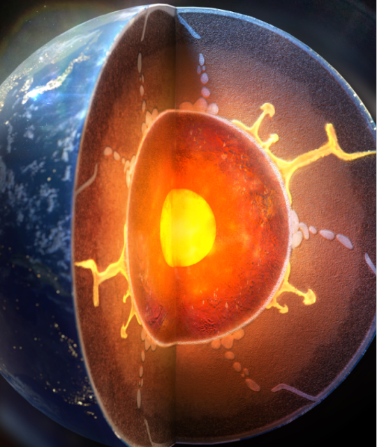
Earth's surface water dives deep, transforming core's outer layer
A few decades ago, seismologists imaging the deep planet identified a thin layer, just over a few hundred kilometers thick. The origin of this layer, known as the E prime layer, has been a mystery — until now.
An international team of researchers, including Arizona State University scientists Dan Shim, Taehyun Kim and Joseph O’Rourke of the School of Earth and Space Exploration, has revealed that water from the Earth's surface can penetrate deep into the planet, altering the composition of the outermost region of the metallic liquid core and creating a distinct, thin layer. Illustration of silica crystals coming out from the liquid metal of the Earth's outer core due to a water-induced chemical reaction.
Their research was recently published in Nature Geoscience.
Research indicates that over billions of years, surface water has been transported deep into the Earth by descending, or subducted, tectonic plates. Upon reaching the core-mantle boundary, about 1,800 miles below the surface, this water triggers a profound chemical interaction, altering the core’s structure.
Along with Yong Jae Lee of Yonsei University in South Korea, Shim and his team have demonstrated through high-pressure experiments that subducted water chemically reacts with core materials. This reaction forms a hydrogen-rich, silicon-depleted layer, altering the topmost outer core region into a film-like structure. Additionally, the reaction generates silica crystals that rise and integrate into the mantle. This modified liquid metallic layer is predicted to be less dense, with reduced seismic velocities, in alignment with anomalous characteristics mapped by seismologists.
Illustration of Earth’s interior revealing subducting water and a rising plume of magma. At the interface where subducting water meets the core, a chemical exchange occurs to form a hydrogen-rich layer in the topmost outer core and dense silica in the bottom of the mantle. Image courtesy Yonsei University
“For years, it has been believed that material exchange between Earth's core and mantle is small. Yet, our recent high-pressure experiments reveal a different story. We found that when water reaches the core-mantle boundary, it reacts with silicon in the core, forming silica," said Shim. "This discovery, along with our previous observation of diamonds forming from water reacting with carbon in iron liquid under extreme pressure, points to a far more dynamic core-mantle interaction, suggesting substantial material exchange.”
This finding advances our understanding of Earth's internal processes, suggesting a more extensive global water cycle than previously recognized. The altered "film" of the core has profound implications for the geochemical cycles that connect the surface-water cycle with the deep metallic core.
This study was conducted by an international team of geoscientists using advanced experimental techniques at the Advanced Photon Source of Argonne National Lab and PETRA III of Deutsches Elektronen-Synchrotron in Germany to replicate the extreme conditions at the core-mantle boundary.
Members of the team and their key roles from ASU are Kim, who began this project as a visiting PhD student and is now a postdoctoral researcher at the School of Earth and Space Exploration; Shim, a professor at the School of Earth and Space Exploration, who spearheaded the high-pressure experimental work; and O’Rourke, an assistant professor at the School of Earth and Space Exploration, who performed computational simulations to comprehend the formation and persistence of the core's altered thin layer. Lee led the research team from Yonsei University, along with key research scientists Vitali Prakapenka and Stella Chariton at the Advanced Photon Source and Rachel Husband, Nico Giordano and Hanns-Peter Liermann at the Deutsches Elektronen-Synchrotron.
7 notes
·
View notes
Text
Deadly swarm of earthquakes in Japan caused by magma moving through extinct volcano

Liquid magma may be moving through an extinct volcano beneath Japan, causing an ongoing earthquake swarm. (Image credit: Abstract Aerial Art/Getty Images)
A huge swarm of earthquakes that has been rocking Japan for three years appears to be the result of fluids moving through an extinct, collapsed volcano, new research suggests.
The swarm is happening on the Noto Peninsula by the Sea of Japan, on the north coast of the country. There has not been volcanic activity in this area for 15.6 million years. However, a new study published June 8 in the journal JGR Solid Earth found that the quakes are occurring in a pattern that suggests liquid magma is still moving around deep below the surface in an ancient, collapsed caldera.
"This earthquake swarm was caused by upward fluid movement through a complex network of faults,"
study lead author Keisuke Yoshida, an Earth scientist at the Research Center for Prediction of Earthquakes and Volcanic Eruptions at Tohoku University in Japan, told Live Science.
The swarm began in December 2020. Since then, there have been over 1,000 magnitude 2 or larger earthquakes, including one magnitude 5.4 quake in June 2022 and a magnitude 6.5 quake in May 2023 that killed one person and injured dozens more.
Related: Scientists discover ancient, underwater volcano is still active — and covered in up to a million giant eggs
Yoshida and his colleagues investigated the swarm by studying the seismic waves from more than 10,000 magnitude 1 or larger quakes that occurred in the area in the past three years.
The magnitude 6.5 earthquake that hit Japan in May killed one person. (Image credit: STR/Getty Images)
They found that the quakes originated 12.4 miles (20 kilometers) deep in the crust, before gradually migrating to shallower depths. This is consistent with fluid ascending through an existing network of faults, the researchers reported. The location of the quake epicenters occurred in a circular pattern, suggesting a ring-like structure to this fault network. This could indicate an ancient, collapsed caldera from a now-extinct volcano.
It's not unusual for long-dead volcanos to still hold pockets of gooey magma, the researchers wrote, and when these fluids move, they can deform the crust and cause faults to slip and slide against one another.
Swarms like this can happen anytime in subduction zones, where the grinding of one plate under another continuously moves fluids around the crust, Yoshida said. It's also possible that the devastating magnitude 9.1 Tohoku earthquake in 2011 set off fluid movement that is still echoing today; that quake was followed by several small swarms in northeastern Japan, Yoshida said.
RELATED STORIES
— Underwater volcano in Antarctica triggers 85,000 earthquakes
—How big is the largest possible earthquake?
—'Mind boggling' array of 19,000 undersea volcanoes discovered with high-resolution radar satellites
The question now, Yoshida said, is how this current swarm transitioned from many small quakes to the large, damaging temblor that occurred in May this year. The team is working to understand how the crust might have been moving without shaking — a phenomenon called aseismic slip — before that quake.
"I would like to obtain information on the transition process from the earthquake swarm to the M6.5 earthquake that occurred in May 2023," Yoshida said. "In particular, we need to know the fluid and aseismic slip conditions prior to the M6.5 earthquake."
Read the full article
0 notes
Text
Sinking seamount offers clues to slow motion earthquakes
2023-06-22 16:09:00Sinking seamount provides ideas to slow movement earthquakesThe very first 3D seismic imaging of a subducting seamount reveals a formerly unidentified sediment path in Earth’s crust off the coast of New Zealand. Researchers believe the sediment spots
Researchers have actually long puzzled over what occurs when seamounts– mountains and volcanoes on the seafloor– are pulled into…

View On WordPress
0 notes
Last Seen Blogs

leehansfish
。∘˚・⋆ ˚。✩🦋Mayee🦋。・゚∘✩。∘

nadaabintab
Noudyyy

sunnbeem
Untitled

longlivejohnnysauce
#LONGLIVEJOHNNYSAUCE

mblueab
Untitled