#Ancestral Puebloan Archaeological Sites
Video

flickr
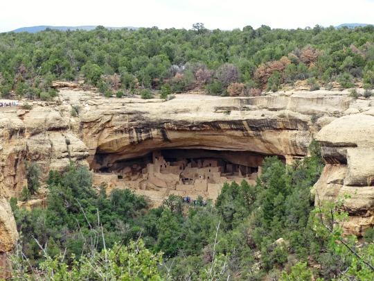
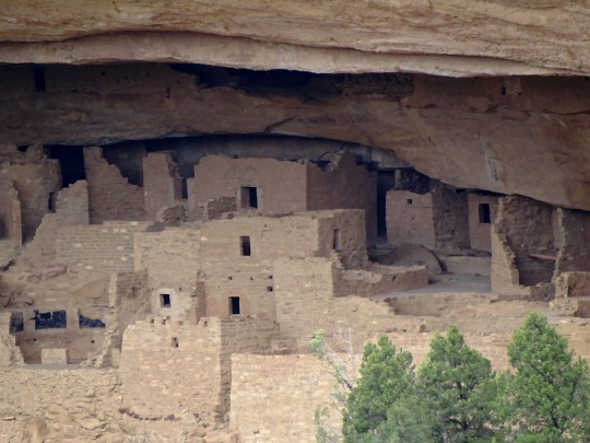
Engulfed in Memories to Share with Mesa Verde National Park by Mark Stevens
Via Flickr:
A setting looking to the southeast while taking in views across cliff dwellings present at the Spruce Tree House in Mesa Verde National Park. This is from an overlook walk while I began hiking the Petroglyph Point Trail. My thought on composing this image was to capture of you of the cliff dwellings and have them run across the image center. I've pulled back a little more on the focal length so that I could include some of the trees and nearby surroundings as a foreground interest and have a layered look beyond. The cliff wall above was also important as it added to the setting and story for how the Ancestral Puebloan people would have to go up and down the walls to get to those dwellings.
#Alcoves#Ancestral Puebloan#Ancestral Puebloan Archaeological Sites#Archaeological Preserve#Archaeological Sites#Azimuth 117#Cliff#Cliff Dwellings#Cliff Walls#Cloudy#Colorado Plateau#Day 5#DxO PhotoLab 7 Edited#Evergreen Trees#Evergreens#Forest#Forest Landscape#Hillside of Trees#Intermountain West#Landscape#Landscape - Scenery#Looking SE#Massive Cliff Dwellings#Mesa Verde National Park#Mostly Cloudy#Nature#New Mexico and Mesa Verde National Park#Nikon D850#No People#Outside
3 notes
·
View notes
Text


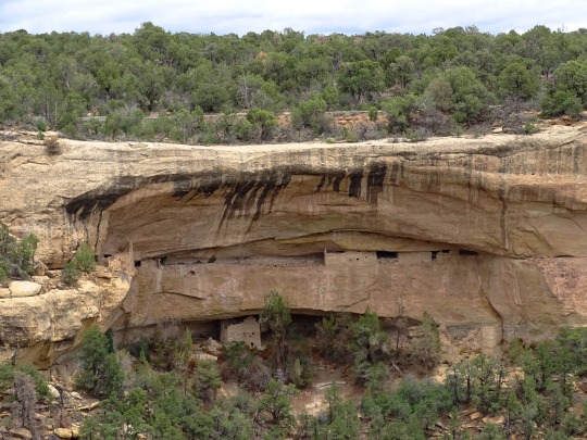
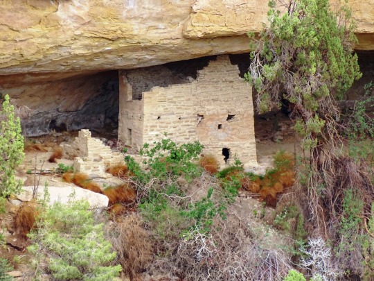
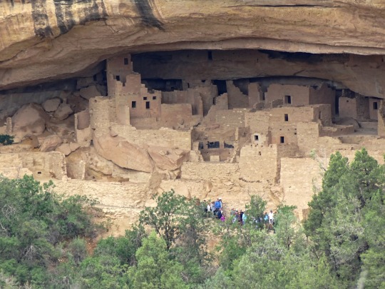

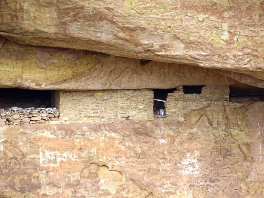
Cliff Palace, Mesa Verde National Park (No. 13)
Cliff Palace is the largest cliff dwelling in North America. The structure built by the Ancestral Puebloans is located in Mesa Verde National Park in their former homeland region. The cliff dwelling and park are in Montezuma County, in the southwestern corner of Colorado, in the Southwestern United States.
Tree-ring dating indicates that construction and refurbishing of Cliff Palace was continuous approximately from 1190 CE through 1260 CE, although the major portion of the building was done within a 20-year time span. The Ancestral Puebloans, also known as Anasazi, who constructed this cliff dwelling and the others like it at Mesa Verde were driven to these defensible positions by "increasing competition amidst changing climatic conditions". Cliff Palace was abandoned by 1300, though debate is ongoing as to the cause. Some contend that a series of megadroughts interrupting food production systems was the main cause.
Cliff Palace was rediscovered in 1888 by Richard Wetherill and Charlie Mason while they were looking for stray cattle.
Source: Wikipedia
#Cliff Palace#Mesa Verde National Park#cliff dwelling#Ancestral Puebloans#Colorado#UNESCO World Heritage Site#ancestral puebloan archaeological site#archaeology#Montezuma County#original photography#desert varnish#travel#vacation#tourist attraction#landmark#architecture#landscape#countryside#summer 2022#USA#Mountain West Region#tree#cliff
211 notes
·
View notes
Note
Hey, would you be willing to elaborate on that "disappearance of the Anasazi is bs" thing? I've heard something like that before but don't know much about it and would be interested to learn more. Or just like point me to a paper or yt video or something if you don't want to explain right now? Thanks!
I’m traveling to an archaeology conference right now, so this sounds like a great way to spend my airport time! @aurpiment you were wondering too—
“Anasazi” is an archaeological name given to the ancestral Puebloan cultural group in the US Southwest. It’s a Diné (Navajo) term and Modern Pueblos don’t like it and find it othering, so current archaeological best practices is to call this cultural group Ancestral Puebloans. (This is politically complicated because the Diné and Apache nations and groups still prefer “Anasazi” because through cultural interaction, mixing, and migration they also have ancestry among those people and they object to their ancestry being linguistically excluded… demonyms! Politically fraught always!)
However. The difficulties of explaining how descendant communities want to call this group kind of immediately shows: there are descendant communities. The “Anasazi” are Ancestral Purbloans. They are the ancestors of the modern Pueblos.
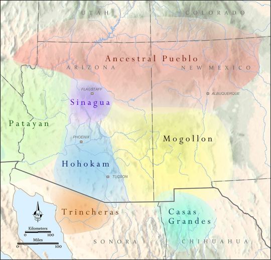
The Ancestral Puebloans as a distinct cultural group defined by similar material culture aspects arose 1200-500 BCE, depending on what you consider core cultural traits, and we generally stop talking about “Ancestral Puebloan” around 1450 CE. These were a group of people who lived in northern Arizona and New Mexico, and southern Colorado and Utah—the “Four Corners” region. There were of course different Ancestral Pueblo groups, political organizations, and cultures over the centuries—Chaco Canyon, Mesa Verde, Kayenta, Tusayan, Ancestral Hopi—but they generally share some traits like religious sodality worship in subterranean circular kivas, residence in square adobe roomblocks around central plazas, maize farming practices, and styles of coil-and-scrape constructed black-on-white and black-on-red pottery.
The most famous Ancestral Pueblo/“Anasazi” sites are the Cliff Palace and associated cliff dwellings of Mesa Verde in southwestern Colorado:

When Europeans/Euro-Americans first found these majestic places, people had not been living in them for centuries. It was a big mystery to them—where did the people who built these cliff cities go? SURELY they were too complex and dramatic to have been built by the Native people who currently lived along the Rio Grande and cited these places as the homes of their ancestors!
So. Like so much else in American history: this mystery is like, 75% racism.
But WHY did the people of Mesa Verde all suddenly leave en masse in the late 1200s, depopulating the whole Mesa Verde region and moving south? That was a mystery. But now—between tree-ring climatological studies, extensive archaeology in this region, and actually listening to Pueblo people’s historical narratives—a lot of it is pretty well-understood. Anything archaeological is inherently, somewhat mysterious, because we have to make our best interpretations of often-scant remaining data, but it’s not some Big Mystery. There was a drought, and people moved south to settle along rivers.
There’s more to it than that—the 21-year drought from 1275-1296 went on unusually long, but it also came at a time when the attempted re-establishment of Chaco cultural organization at the confusingly-and-also-racist-assuption-ly-named Aztec Ruin in northern New Mexico was on the decline anyway, and the political situation of Mesa Verde caused instability and conflict with the extra drought pressures, and archaeologists still strenuously debate whether Athabaskans (ancestors of the Navajo and Apache) moved into the Four Corners region in this time or later, and whether that caused any push-out pressures…
But when I tell people I study Southwest archaeology, I still often hear, “Oh, isn’t it still a big mystery, what happened to the Anasazi? Didn’t they disappear?”
And the answer is. They didn’t disappear. Their descendants simply now live at Hopi, Zuni, Taos, Picuris, Acoma, Cochiti, Isleta, Jemez, Laguna, Nambé, Ohkay Owingeh, Pojoaque, Sandia, San Felipe, Santa Clara, San Ildefonso, Tamaya/Santa Ana, Kewa/Santo Domingo, Tesuque, Zia, and Ysleta del Sur. And/or married into Navajo and Apache groups. The Anasazi/Ancestral Puebloans didn’t disappear any more than you can say the Ancient Romans disappeared because the Coliseum is a ruin that’s not used anymore. And honestly, for the majority of archaeological mysteries about “disappearance,” this is the answer—the socio-political organization changed to something less obvious in the archaeological record, but the people didn’t disappear, they’re still there.
351 notes
·
View notes
Text
A crash course in some vocabulary
Archaeology, like all sciences, has a lot of specialized jargon we use to talk about pottery. To make sure everyone’s on the same page, here’s a list of some common terms I’ll be using, what they mean, and how to pronounce them.
~ 🏺🏺🏺 ~
Ware: A broader term for a technological/cultural tradition in pottery. Typically, construction method, color, clay type, temper type, and paint type are what defines a “ware.” So Chuska Gray Ware is unslipped, usually unpainted gray clay with crushed black basalt temper. Roosevelt Red Ware is red-slipped clay with sand temper and carbon-based paint. Hohokam Buff Ware is unslipped or cream-slipped buff-colored clay with coarse sand temper, created using a paddle-and-anvil forming method and painted with red paint.
Type: Within a ware, a type is a more narrowly specific decorative style. Roosevelt Red Ware has multiple types within it, such as Salado Red (unpainted red-slipped), Pinto Black-on-red (black paint on the red in a specific radially symmetric interlocked hatched-and-bold pattern), Pinto Polychrome (same decorative style but on a white-slipped interior field), Gila Polychrome (red exterior, white-slipped interior, a usually-broken black band around the rim, black painted designs in a two- or -four-fold symmetry), Tonto Polychrome (bolder and less symmetric black-and-white designs on a red field), Cliff Polychrome, Dinwiddie Polychrome, Nine Mile Polychrome… different stylistic variations on the Roosevelt Red Ware technological/visual core. You can read more about categorizations here.
A note on naming conventions: Pottery in this archaeological tradition tends to have a two-part name: a location where it was first defined and described, and a colorway. Wares tend to be “[Broad location or broad cultural group] [Color] Ware”; types tend to be “[Specific site] [paint color]-on-[clay color].” So within Tusayan White Ware is Flagstaff Black-on-white.
———
Gila: A river in southern Arizona and a bit of New Mexico, and a lizard and a polychrome type named after it. Pronounced hee-la.
Hohokam: An archaeological term for a Native American cultural group that lived in southern Arizona and northern Sonora, defined by traits like red-on-buff pottery, massive canal systems for field irrigation, and platform mounds. It comes from the O'odham-language word huhugham, “ancestors.” They are the ancestors of the modern Tohono O’odham and Akimel O’odham people (it’s a little bit more complicated than that but that’s basically the case.)
Mogollon: An archaeological term for a Native American cultural group from central New Mexico, eastern Arizona, and northern Chihuahua. Most iconic trait is the elaborate range of corrugated and smudged pottery. Named after the Mogollon Rim, the geological formation that marks the edge of the Colorado Plateau and a drastic change in geology and climate in the northern Southwest and the southern Southwest. Along with the Ancestral Pueblo, the Mogollon culture are ancestors of modern southern Rio Grande and Zuni pueblos. Pronounced moh-guh-yon.
Olla: A water jar with a wide body and narrow neck. Pronounced oy-ya.
Polychrome: Pottery that is three or more colors (poly+chrome), most often meaning red, white, and black.
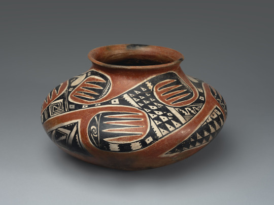
A Tonto Polychrome olla. Southeastern Arizona, 1350-1450.
Pueblo: A collective term for Native people of the Southwest US (particularly in the Rio Grande river watershed, but also Hopi and Zuni) who share cultural traits and history—most immediately notably, a tradition of living in square adobe houses in large villages, which are also each called pueblos. Ancestral Pueblo is the term for the archaeologically-defined cultural group that share these similar traits and are, generally, from the northern half of New Mexico and Arizona, and a southern strip of Colorado and Utah. The Ancestral Puebloans were formerly called “Anasazi” but that has fallen out of favor due to pushback from modern Pueblos. Also, each modern Pueblo prefers to be called a Pueblo rather than a tribe in most cases—so you say the Pueblo of Acoma, the Pueblo of Ohkay Owingeh, Picuris Pueblo, Taos Pueblo, the Pueblo of Zuni, etc.
Temper: Non-clay bits that are added to natural clays to make them easier to work with. When you buy clay from a store now, it’s already mixed and processed and ready to use. When you find clay out in nature, it’s almost never so easy. Typically, you have to mine/harvest clay from riverbanks or cliffsides, and it’s hard and dried; then you have to grind the hard clay up into fine particles, and mix them with water. But natural clays are often puddly and don’t always hold together well, so you add temper, something hard and grainy to make your wet clay stick together more easily and make it good to work with! Temper can be sand, ground-up rock, ground-up shell, or even ground-up bits of other broken pottery. What different people used as temper is one defining feature of a pottery ware and pottery tradition.
Sherd: A broken bit of pottery. NOT shard. When it’s pottery, it’s “sherd.”
Slip: Very runny wet clay. It’s used to help attach clay pieces together, but more pertinently here, plain-colored pots are covered with an even layer of bolder-colored clay slip to get the desired color pot.
Smudging: A decorative style that potters made during the firing stage. They would have open pit-fires for firing their pottery, and cover the desired part of the pot with a layer of charcoal or ash. This creates a carbonized, reducing environment—that is, a lot of carbon, and little oxygen. This creates a smooth, inky black finish on the completed pot.
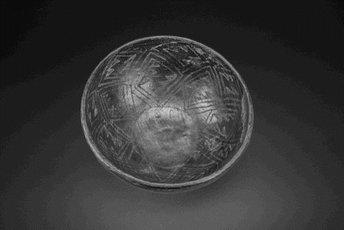
A Starkweather Smudged bowl. Mogollon, western New Mexico, AD 900-1200.
Vessel: Another word for pot, basically. Means a ceramic container of some sort. Bowls, jars, ladles, pitchers, mugs, etc are all vessels; effigies and statuettes are not.
42 notes
·
View notes
Text
In an unthinking act of destruction by a hopeful treasure hunter/looter, a 1,000-year-old archaeological site in Utah's Fort Pearce Wash Area has suffered irreversible damage. The perpetrator, a 51-year-old man, dug a massive 15-foot-deep trench in search of treasure, disturbing a site rich in history and significance.
The area, renowned for its collection of over 100 petroglyphs dating back 500 years or more, is now tainted by this reckless act. The vandalism has disrupted crucial archaeological evidence, potentially erasing invaluable insights into the region's ancestral Puebloan culture.
35 notes
·
View notes
Photo
Homolovi
Homolovi or Homolovi State Park (formerly: Homolovi Ruins State Park) is a cluster of archaeological sites that contains the ruins of eight pre-Columbian Ancestral Puebloan (Anasazi) and Hopi pueblos in addition to some 300 other remains and petroglyphs. Homolovi lies within sight of the Little Colorado River in a floodplain, 2 km (4 miles) northeast of Winslow, Arizona in the United States. Archaeologists believe that Ancestral Puebloan peoples and the ancestors of the Hopi tribe once occupied these settlements, which spread out along a 32 km (19 miles) corridor on the Little Colorado River, at different intervals of time from c. 1250-1425 CE. Two pueblos - Homolovi I and Homolovi II - each contained more than 1,000 rooms in ancient times, and 40 ceremonial kivas are scattered throughout the park. The Homolovi ruins are unique in the ancient Southwest as they have helped archaeologists better understand the cultural transitions and social changes that occurred in the region during the 13th through 14th centuries CE. Four of the sites at Homolovi are listed on the U.S. National Register of Historic Places, and the park is currently managed by the Arizona State Park system.
Learn more about Homolovi
57 notes
·
View notes
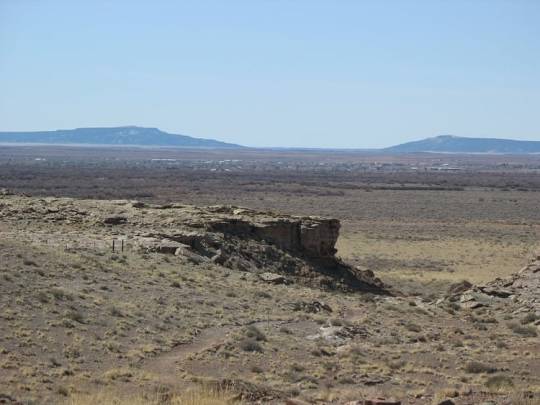
Text
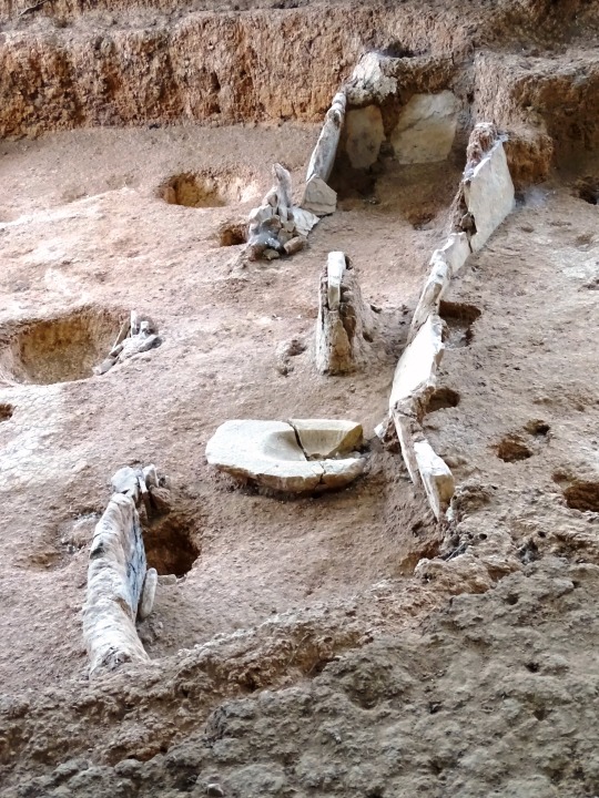
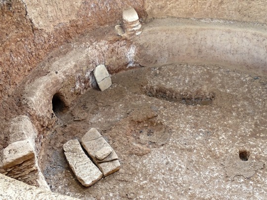
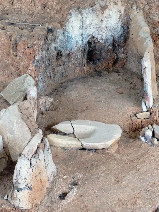
also in the beautiful red cliffs national conservation area, an Ancestral Puebloan archaeological site with the remains of pit houses and storage pits used on and off from 500-1200 ce


4 notes
·
View notes
Link
New Video!
6 notes
·
View notes
Text

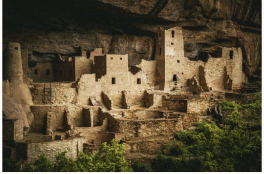
Cliff Palace, Mesa Verde NM
The Ancestral Puebloans, also known as the Anasazi, were an ancient Native American culture that spanned the present-day Four Corners region of the United States, comprising southeastern Utah, northeastern Arizona, northwestern New Mexico, and southwestern Colorado.[1] They are believed to have developed, at least in part, from the Oshara tradition, which developed from the Picosa culture. The people and their archaeological culture are often referred to as Anasazi, meaning "ancient enemies", as they were called by Navajo. Contemporary Puebloans object to the use of this term, with some viewing it as derogatory.[2][3]
The Ancestral Puebloans lived in a range of structures that included small family pit houses, larger structures to house clans, grand pueblos, and cliff-sited dwellings for defense. They had a complex network linking hundreds of communities and population centers across the Colorado Plateau. They held a distinct knowledge of celestial sciences that found form in their architecture. The kiva, a congregational space that was used mostly for ceremonies, was an integral part of the community structure.
Archaeologists continue to debate when this distinct culture emerged. The current agreement, based on terminology defined by the Pecos Classification, suggests their emergence around the 12th century BC, during the archaeologically designated Early Basketmaker II Era. Beginning with the earliest explorations and excavations, researchers identified Ancestral Puebloans as the forerunners of contemporary Pueblo peoples.[1][3] Three UNESCO World Heritage Sites located in the United States are credited to the Pueblos: Mesa Verde National Park, Chaco Culture National Historical Park and Taos Pueblo.
2 notes
·
View notes
Text
Alkali Ridge
Alkali Ridge
Alkali Ridge contains the archaeological remains of a village scattered over a 240 x 500-foot area. The extensive ceramic collection gathered at the site suggests intermittent occupation of the ridge over several centuries. The remains include pit dwellings, which are regarded as the earliest forms of Ancestral Puebloan architecture, as well as multi-story rectangular rooms and…
View On WordPress
0 notes
Video
Planned to Visit in 2020, But Delayed Because of a Pandemic to 2023! (Mesa Verde National Park) by Mark Stevens
Via Flickr:
While walking the Petroglyph Point Trail and a view looking to the southeast to the Spruce Tree House and cliff dwelling. This is located in Mesa Verde National Park. My thought on composing this image was to pull back on the focal length and include the surrounding landscape to add flavor to this Ancestral Puebloan site and national park in Colorado. I liked the layered look with the nearby rock wall and trees that made it seem like a look beyond to those cliff dwelling on the other side of the mesa. I did some initial post-processing work making adjustments to contrast, brightness and saturation while playing around as I learned how to work with DxO PhotoLab 7. I then exported a TIFF image to Nik Color Efex Pro 4 where I added a Polarization, Foliage, and Pro Contrast filter for that last effect on the image captured. The caption for the image was a reference to the fact that I had planned to make this visit and trip in April 2020, but the world kind of shut down with the beginning of the Covid pandemic. I was able to plan out for this national park visit back in September 2023 and savored this moment as a "finally!"
#Alcoves#Ancestral Puebloan#Ancestral Puebloan Archaeological Sites#Archaeological Preserve#Archaeological Sites#Azimuth 118#Cliff Dwellings#Cloudy#Color Efex Pro#Colorado Plateau#Day 5#DxO PhotoLab 7 Edited#Evergreen Trees#Evergreens#Forest#Forest Landscape#Hillside of Trees#Intermountain West#Landscape#Landscape - Scenery#Looking SE#Massive Cliff Dwellings#Mesa Verde National Park#Mostly Cloudy#Nature#New Mexico and Mesa Verde National Park#Nikon D850#No People#Outside#Overcast
2 notes
·
View notes
Text
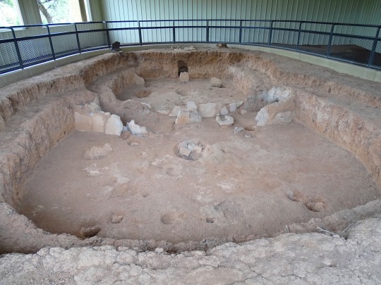
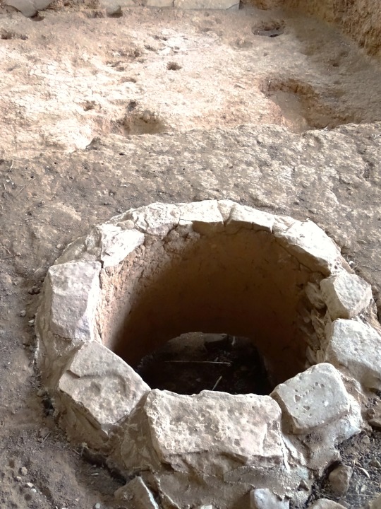


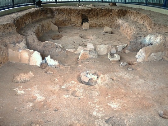


Mesa Verde National Park (No. 10)
With the introduction of corn to the Mesa Verde region c. 1000 BC and the trend away from nomadism toward permanent pithouse settlements, the Archaic Pueblonians transitioned into what archaeologists call the Basketmaker culture. Basketmaker II people are characterized by their combination of foraging and farming skills, use of the atlatl, and creation of finely woven baskets in the absence of earthen pottery. By 300, corn had become the preeminent staple of the Basketmaker II people's diet, which relied less and less on wild food sources and more on domesticated crops.
In addition to the fine basketry for which they were named, Basketmaker II people fashioned a variety of household items from plant and animal materials, including sandals, robes, pouches, mats, and blankets. They also made clay pipes and gaming pieces. Basketmaker men were relatively short and muscular, averaging less than 5.5 feet (1.7 m) tall. Their skeletal remains reveal signs of hard labor and extensive travel, including degenerative joint disease, healed fractures, and moderate anemia associated with iron deficiency. They buried their dead near or amongst their settlements, and often included luxury items as gifts, which might indicate differences in relative social status. Basketmaker II people are also known for their distinctive rock art, which can be found throughout Mesa Verde. They depicted animals and people, in both abstract and realistic forms, in single works and more elaborate panels. A common subject was the hunchbacked flute player that the Hopi call Kokopelli.
Source: Wikipedia
#Badger House Community#Wetherill Mesa#antechamber#pithouse#semi-subterranean home#Mesa Verde National Park#UNESCO World Heritage Site#Paleo-Americans#Mountain West Region#ancestral puebloan archaeological site#Montezuma County#Native American history#archaeology#ruins#tourist attraction#landmark#travel#vacation#summer 2022#Colorado#USA#original photography#flora#landscape#countryside
107 notes
·
View notes
Text
0 notes
Photo

Utah’s Dark Canyon Complex Deep, meandering canyons cut through the Colorado Plateau in southeastern Utah in this photograph, taken by an astronaut on the International Space Station on April 6, 2023. These canyons, known as the Dark Canyon complex, have distinctive geology, ecology, and archeology. They are some of the only intact protected canyons in the United States. This rugged and remote landscape has been shaped by erosion. Over thousands of years, the Colorado River and smaller tributaries have eroded winding, steep-walled canyons into the sedimentary rock. Dark Canyon—one of seven canyons within the complex—cuts diagonally across the photo. Within this canyon, sandstone walls tower up to 3,000 feet (900 meters), shading visitors from morning and afternoon sun—hence its name. The canyon’s steep walls expose roughly 250 million years of geologic history and contain deposits from the Permian period. Cockleshell and crinoid stem fossils have been found in the area. The Colorado River flows in from Canyonlands National Park, located just 6 miles (10 kilometers) northeast of this view. The confluence of the Green and Colorado rivers in Canyonlands creates powerful rapids down river. This segment of the river—part of Glen Canyon National Recreation Area—is known as Cataract Canyon and is notorious for its hazardous whitewater rafting conditions. Springs, hanging gardens, riparian areas, and mesas provide habitat for a wide range of wildlife around the Dark Canyon complex. Golden eagles, peregrine falcons, and the Mexican spotted owl have been observed in the complex. Dark Canyon itself extends east beyond the photo into a designated wilderness area in the Manti-La Sal National Forest. The Dark Canyon complex is part of Bears Ears National Monument, which contains many cultural and archaeological sites. According to a presidential proclamation issued October 2021, Bears Ears is sacred land to several Tribal Nations and Pueblos. Although Ancestral Puebloan occupation seems to have been somewhat sparser in Dark Canyon compared to canyons farther south, cliff dwellings, petroglyphs, and lithic scatters do exist within this area. Astronaut photograph ISS069-E-001017 was acquired on April 6, 2023, with a Nikon D5 digital camera using an 400 millimeter lens and is provided by the ISS Crew Earth Observations Facility and the Earth Science and Remote Sensing Unit, Johnson Space Center. The image was taken by a member of the Expedition 69 crew. The image has been cropped and enhanced to improve contrast, and lens artifacts have been removed. The International Space Station Program supports the laboratory as part of the ISS National Lab to help astronauts take pictures of Earth that will be of the greatest value to scientists and the public, and to make those images freely available on the Internet. Additional images taken by astronauts and cosmonauts can be viewed at the NASA/JSC Gateway to Astronaut Photography of Earth. Story by Emily Cassidy.
0 notes
Note
It is generally accepted that the first inhabitants of North America migrated from Siberia by way of the Bering land bridge and arrived at least 12,000 years ago; however, some evidence suggests an even earlier date of arrival.[33][34][35] The Clovis culture, which appeared around 11,000 BC, is believed to represent the first wave of human settlement of the Americas.[36][37] This was likely the first of three major waves of migration into North America; later waves brought the ancestors of present-day Athabaskans, Aleuts, and Eskimos.[38]
Over time, indigenous cultures in North America grew increasingly sophisticated, and some, such as the pre-Columbian Mississippian culture in the southeast, developed advanced agriculture, architecture, and complex societies.[39] The city-state of Cahokia is the largest, most complex pre-Columbian archaeological site in the modern-day United States.[40] In the Four Corners region, Ancestral Puebloan culture developed from centuries of agricultural experimentation.[41] The Algonquian are one of the most populous and widespread North American indigenous peoples. This grouping consists of the peoples who speak Algonquian languages.[42] Historically, these peoples were prominent along the Atlantic Coast and into the interior along the Saint Lawrence River and around the Great Lakes. Before Europeans came into contact, most Algonquian settlements lived by hunting and fishing, although many supplemented their diet by cultivating corn, beans and squash (the "Three Sisters"). The Ojibwe cultivated wild rice.[43] The Haudenosaunee confederation of the Iroquois, located in the southern Great Lakes region, was established at some point between the twelfth and fifteenth centuries.[44]
(FUCK MERICA)
1 note
·
View note
Text


TCAS [email protected] via gmail.mcsv.net
4:40 PM (24 minutes ago)
This Tuesday, Mar 7th at 7:00pm in Mountainair, Steven Rospopo will speak about Middle San Juan Archeology at the Point Great House Site and the Tommy Site in his presentation 'Economies of Destruction at Point Pueblo'.
This Torrance County Archaeological Society event is open to all and will be presented at the Manzano Mountainair Art Council Center at 101 E. Broadway in Mountainair at 7:00pm.
Link to Steven Rospopo's full presentation announcement and MMAC Center directions:
https://outlook.us17.list-manage.com/track/click?u=43e3fcde320096b06cddccde6&id=a02a4f8b55&e=e193ba84b9
Steven Rospopo has 11 years of experience in Southwestern archeology and is currently a master’s candidate in Southwest Studies at New Mexico Highlands University. Steven has a B.S. in Biology, B.A. in Chemistry and B.S. in Mechanical Engineering from the University of New Mexico. His research has focused primarily on the Ancestral Puebloan Chaco Outliers in the Middle San Juan Basin, especially during the late Chaco Phenomenon period. His thesis research regards the Ritual of Destruction Caching Behaviors in the Chaco Phenomenon Sphere of Influence.
Don't miss the 'Economies of Destruction at Point Pueblo'! Refreshments and snacks will be served.
1 note
·
View note
Last Seen Blogs
gnashingwailing
good g/t has me feeling like.

not-stressed
Trying My Best

honeyhomesca
Honey Homes

donvilaro
Don Vilaro's Lair