#Equatorial Ridge
Text
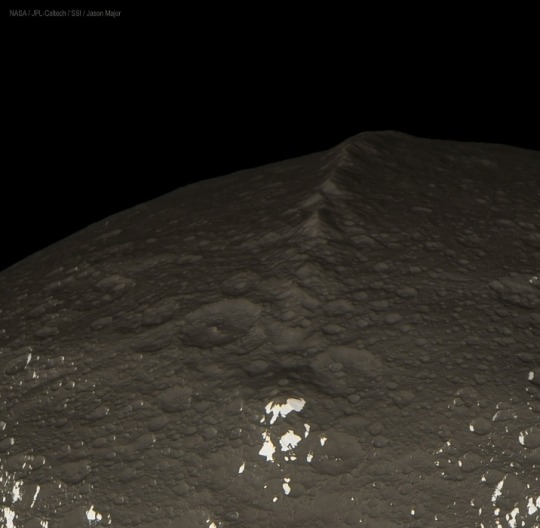

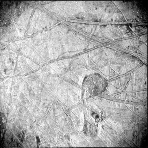
Clearest images ever taken of Equatorial Ridge on Saturn's moon Iapetus.
—
The equatorial ridge is the tallest mountain feature on Saturn's moon Iapetus.
It is 20 km (12 mi) high and is the third tallest mountain structure in the Solar System.
It runs along most of Iapetus' equator. It was discovered by the Cassini probe on 31 December 2004.
Cassini–Huygens, commonly called Cassini, was a space-research mission by NASA, the European Space Agency (ESA), and the Italian Space Agency (ASI) to send a space probe to study the planet Saturn and its system, including its rings and natural satellites.
#Saturn#Equatorial Ridge#Iapetus#moon#planet#astronomy#Cassini#Solar System#Cassini–Huygens#space probe#NASA#European Space Agency (ESA)#Italian Space Agency (ASI)
90 notes
·
View notes
Text


Sargasso Sea/Within the Bounds of the North Atlantic Gyre (National Oceanic & Atmospheric Administration, March 2021)
#your mind and you are our sargasso sea#north atlantic ocean#north atlantic gyre#gulf stream#north atlantic current#canary current#north atlantic equatorial current#bermuda#sargassum seaweed#muhammad al-idrisi#north atlantic ridge#european eel#windless sea#loggerhead sea turtles#cartography#maps#satellite images#oceanography#charting the oceans#ezra pound#sargasso sea#satellite oceanography
8 notes
·
View notes
Text
Inner Wall Explosions
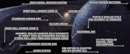
STAR WARS EPISODE I: The Phantom Menace 02:03:02
#Star Wars#Episode I#The Phantom Menace#Naboo system#Battle of Naboo#Vuutun Palaa#Droid Control Ship#Lucrehulk-class LH-3210#LH-1740 modular control core#droid signal receiver station#inner wall hangar#starboard hangar arm#Vulture droid starfighter#Zone 3#Zone 1#secondary docking arm#backup sensor rectenna#locking ridge#particle shield#equatorial bay#centersphere
0 notes
Text

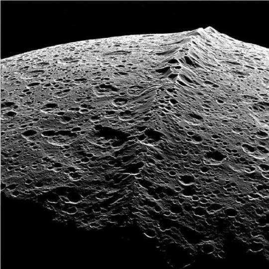
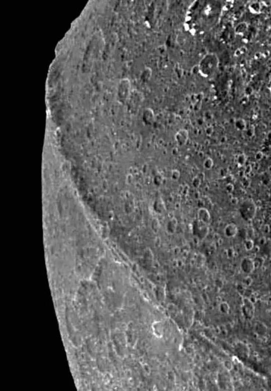

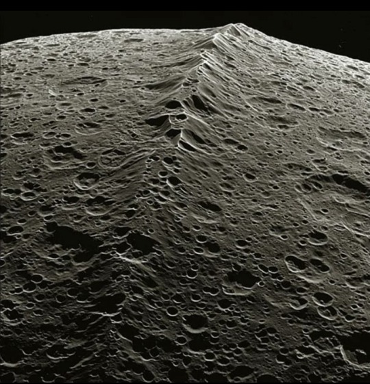
Here's a rare mind blowing moment in the astronomy world. Clearest images ever taken of Equatorial Ridge on Saturn's moon 'Iapetus'.
#saturn planet#saturn#planets#planet#astronomers#astrography#astrophysics#astrophotography#astrology#astronomy#astro observations#astro notes#space station#space science#space exploration#outer space#space#hubble space telescope#james webb space technology#nasa#universe#nasa photos#nasawebb#cosmos#space photography#our universe#telescope#nasa picture of the day#solar system
3K notes
·
View notes

Text
The Qurri settle, a Deep One rises & the Messonir muster
Tepponilamek has 0 + 3 + (2d6 => 5 + 4 = 9) – 1 = 11 power. Under Tepponilamek’s influence, the Qurri build their first city on Velarie’s Isle (-3), and a malicious Algaekin, Charvor, builds a base of power on Incarien (-3). The Messonir of Tsallosis prepare for war, forming an army in Tsallosis (-2).
Tepponilamek’s influence continues this great age of settlement building. The Qurri have developed a reasonable shipbuilding tradition, although they mainly limit themselves to short hops between coastal regions rather than risk long open-sea voyages. Many Qurri have spread westwards amongst the isles of the equatorial regions, including some settling upon Velarie’s isle; whever there is the dense jungle suitable for the Huk to breed, there the Qurri settle.
The Qurri, who have steadily grown in numbers and spread across the equatorial islands of the world, make landfall on Velarie’s Isle and discover it to be a perfect home for them, well suited to the Huk. On the southwestern edge, the population on the Isle grows rapidly and soon a city, Qattangu, is founded. Lying in a sheltered cove with high Huk-filled forests along two ridges nearby, the city is ruled by the akelish system; a Qurri leadership system where there are three chiefs (or in this case, monarchs, for the Qurri of Qattangu imitate foreign peoples they have contacted in naming themselves ‘king’) in a hierarchy of seniority; when the eldest becomes a Huk the two less senior kings ascend in seniority, and then choose between them an apprentice to be the new youngest king.
Meanwhile, a sinister presence builds in Incarien. The algaekin Kǎlkayer, after centuries of learning about the surface world, desires to perfect it, uniting all the weak creatures of flesh by converting them to its own more beautiful forms. It surfaces on the coast of Incarien just northwest of Velarie’s isle, and begins to convert local wildlife (and any unfortunate mortals) to itself; it allows each drone a significant degree of autonomy, but ultimately all are made to serve itself. It makes its home in a vast river delta, where its drones cultivate vast mats of new algae and bring corpses for it to inhabit. At present it is only a local threat, but it could soon grow to something more.
The steady increase in raids upon cities in the Ajuna valley by the desert Ohmlings finally prompt a response. Perhaps in past centuries the Messonir would have tarried longer before acting; thanks to the steadily growing power of the Council of Eight, they have begun to act. Resources are diverted from the gathering of knowledge to the forging of arms; larger cities have walls built around them; individual cities begin to organise militias under the direction of the Council, who also organise a central standing army to respond wuickly to Ohmling attacks. There are even contributions from the Penitent; small bands of warrior-monks and seers make their way south from Lekesh to the valley of the Ajuna, and both aid in the training of the Messonir army and in fighting off the ever more numerous raids. But the Messonir know the worst is yet to come.
4 notes
·
View notes
Photo
Juno gets highest-resolution close-up of Jupiter's moon Europa Observations from the spacecraft's pass of the moon provided the first close-up in over two decades of this ocean world, resulting in remarkable imagery and unique science. The highest-resolution photo NASA's Juno mission has ever taken of a specific portion of Jupiter's moon Europa reveals a detailed view of a puzzling region of the moon's heavily fractured icy crust. The image covers about 93 miles (150 kilometers) by 125 miles (200 kilometers) of Europa's surface, revealing a region crisscrossed with a network of fine grooves and double ridges (pairs of long parallel lines indicating elevated features in the ice). Near the upper right of the image, as well as just to the right and below center, are dark stains possibly linked to something from below erupting onto the surface. Below center and to the right is a surface feature that recalls a musical quarter note, measuring 42 miles (67 kilometers) north-south by 23 miles (37 kilometers) east-west. The white dots in the image are signatures of penetrating high-energy particles from the severe radiation environment around the moon. Juno's Stellar Reference Unit (SRU)—a star camera used to orient the spacecraft—obtained the black-and-white image during the spacecraft's flyby of Europa on Sept. 29, 2022, at a distance of about 256 miles (412 kilometers). With a resolution that ranges from 840 to 1,115 feet (256 to 340 meters) per pixel, the image was captured as Juno raced past at about 15 miles per second (24 kilometers per second) over a part of the surface that was in nighttime, dimly lit by "Jupiter shine"—sunlight reflecting off Jupiter's cloud tops. Designed for low-light conditions, the SRU has also proven itself a valuable science tool, discovering shallow lightning in Jupiter's atmosphere, imaging Jupiter's enigmatic ring system, and now providing a glimpse of some of Europa's most fascinating geologic formations. "This image is unlocking an incredible level of detail in a region not previously imaged at such resolution and under such revealing illumination conditions," said Heidi Becker, the lead co-investigator for the SRU. "The team's use of a star-tracker camera for science is a great example of Juno's groundbreaking capabilities. These features are so intriguing. Understanding how they formed—and how they connect to Europa's history—informs us about internal and external processes shaping the icy crust." It won't just be Juno's SRU scientists who will be busy analyzing data in the coming weeks. During Juno's 45th orbit around Jupiter, all of the spacecraft's science instruments were collecting data both during the Europa flyby and then again as Juno flew over Jupiter's poles a short 7 ½ hours later. "Juno started out completely focused on Jupiter. The team is really excited that during our extended mission, we expanded our investigation to include three of the four Galilean satellites and Jupiter's rings," said Juno Principal Investigator Scott Bolton of the Southwest Research Institute in San Antonio. "With this flyby of Europa, Juno has now seen close-ups of two of the most interesting moons of Jupiter, and their ice shell crusts look very different from each other. In 2023, Io, the most volcanic body in the solar system, will join the club." Juno sailed by Jupiter's moon Ganymede—the solar system's largest moon—in June 2021. Europa is the solar system's sixth-largest moon with about 90% the equatorial diameter of Earth's moon. Scientists are confident a salty ocean lies below a miles-thick ice shell, sparking questions about the potential habitability of the ocean. In the early 2030s, the NASA's Europa Clipper spacecraft will arrive and strive to answer these questions about Europa's habitability. The data from the Juno flyby provides a preview of what that mission will reveal. IMAGE.....Surface features of Jupiter’s icy moon Europa are revealed in an image obtained by Juno’s Stellar Reference Unit (SRU) during the spacecraft’s Sept. 29, 2022, flyby. Credit: NASA/JPL-Caltech/SwRI
7 notes
·
View notes
Text
In Which Talys Rants About His Latest (resurgent) Hyperfixation Instead Of Going To Sleep
;It’s exactly what it says in the title. The past week and a half have been a spiral of anxiety depression and ADHD and that has somehow led me into rediscovering my hyperfixation for mapmaking, using the world of FTEITS as a case study.
Mostly it’s an excuse to show my progress and go

(shout-out to the useless tumblr GIF keyboard that forced me to leave tumblr and google the gif)
Methodology and Tools
I’m using Artifexian’s excellent worldbuilding and atlas mapping series, plus supplemental research whenever he doesn’t provide enough information for my specific case.
As for tools, aside from GPlates from Artifexian, I use Affinity Designer, because it’s a single purchase instead of Adobe’s hell subscription and I find the free vector programs like Inkscape too limiting.
Step One: Get your old shit together
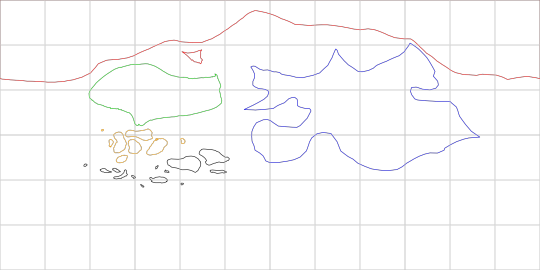
So, I’ve drawn the world of FTEITS (I refer to it as “world of four” internally, a moniker which loses meaning the further I stop treating four as my arc number, but whatever) on paper years ago. Here’s an almost-up-to-date scan (the one I used as reference for all this)

A year ago I already tried doing this exact process I’m doing it now: basically using GPlates to project that on a sphere, then drawing continents to adjust the shape directly on a globe, which got me here
Step Two: Adjust that shit and get some climates
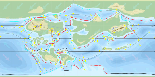
Climate zones are one of the things I wanted to do this whole thing for. Basically I’m fine drawing whatever shape, but I thought it would be easier to flesh out the world with a more systematic approach.
I technically started this last year too, including the tectonic plates (basically I already knew where I wanted mountains, so I added plates to justify their existence). I also adjusted the shape of the continent known as Aarde (name subject to change as 2022 me is a lot keener than 2012 me that maybe using Dutch as the basis for the language of your majority black continent “because Afrikaans” is actually a bad idea) because I realized it was too small and my southern hemisphere too empty.
I also decided to add a couple islands in the southeast, adjusted the shape of that continent since I wanted a monsoon circulation there and it turns out you need an equatorial ocean for that to happen.

Step Three: Fill in more shit like resources, then realize you completely messed up ocean circulation
Basically what that says. Ocean currents dictate a lot (including climates, but also stuff like fishing hotspots). And I completely misunderstood the way ocean currents work.
So I decided to add what is essentially a submerged continent to the south pole to create some fishing hotspots near the (still needs to be renamed) Moeder Eiland, and also made shitty annotations on the map before I went back to the drawing board.
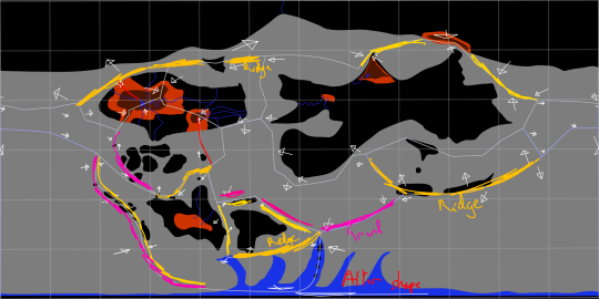
Basically marking ocean ridges and trenches, and a sketch of that continent knowing that I’d go back to GPlates to make it look okay on a sphere.
Step Four: Actually execute concept
The only thing I actually did in gplates was redo my tectonic plates and draw that submerged continent. Oh, and also, I added a mountain range to the southeast of Eogua. Which, ironically, I then found my paper map for an unrelated thing (I forgot what the other mountain range was named) and found that at some point in the past, I independently had already decided to add a mountain range there. So. I did that.
I also started doing an elevation map in more details (this one is incompete; i focused on getting the mountains done first since they also influenced climates which, again, were my primary goal here). With my tablet and pencil, this actually starts to look like, you know, a map? Madness.
Step Five: Work, work, work
So it turns out that an elevation map takes a ton of work. No wonder I never finished the first one. If the brain worms hadn’t dictated it now I don’t know how I would have done it.
Oh, also I adjusted some shit near the poles since distortions and all that. So that was another round in GPlates too.

Oh hey, this is finished, right? Right???
Step Six: Realize you fucked up ocean currents again
In my defense, I’d say the artifexian guide on that is just. not great.
Anyway between that and a first iteration on climate zones I realized it was time to adjust some shapes again. Which. Maybe I should have checked my climates before I finished the elevation map so these changes didn’t have to cascade across a bunch of different layers.
So I adjusted the landmasses for my main setting, shifting it north…
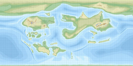
And then finally I redid the currents to get something that I think is more or less correct, or as close to correct as I’m bothered getting anyway

Oh, and I added more islands. I don’t even know if they’re visible in this file size lmao
Step Seven: Realize If You Want To Export Many Maps You’re Gonna Be In Trouble
Okay so Affinity programs have this “Persona” feature which lets you essentially switch modes. One of them is the Export persona that lets you say “these are the outputs I want from my file”
Problem is (and this is a feature people have asked but hasn’t come yet) all you can do there is slice your file. I would have liked if instead my slices were like “this and that layer for the elevation map, this and that layer for the climate map” but i guess that’s not in the cards right now
So…I cut my file into a bunch of artboards, and used the Symbol feature to ensure that each artboard was synced (a symbol basically flags a layer so that every duplicate of that layer will be edited at the same time, and you can even scale them differently, etc etc). For now I have three artboards, but I can already tell I’ll probably need to split them up further, for instance if I want an export for the tectonic map.
But for now it’s a topograhy map, a climate zone map, and a sociopolitical map. The first two are complete (you know, barring potential changes and iterations, but I consider them done). The third is just a sketch where I plopped down the major cities, I’ll be adding more stuff as I figure out how to do it.

Needless to say, it’s not great to look at but whatever.
Step Eight: Waste Almost An Hour Writing A Tumblr Post About All This
In my defense, the beta post editor did decide to crash on me. It does not handle moving pictures around well. I’m writing this using the old, non-beta editor now.
And so, finally, the higher-quality files (higher because i did have to add an export to JPEG just so tumblr would accept the goddamn files)


And once again:
#talysnovel: fteits#this is probably the most in depth i've gotten about the world on tumblr#talys makes maps
2 notes
·
View notes
Text
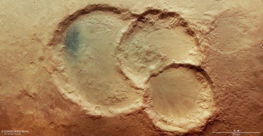
As a geologist, mars impact craters immediately took my interest among the wide range of available data sets. That is why I aim to focus on the new global database for Mars created by Stuart Robbins. Specifically, I would like to focus on answering the question: "Is ejecta morphology associated with latitudinal variation?". I would like to study if there is a dominant ejecta morphology per latitude zone (e.g. equatorial latitudes, midlatitudes, northern/southern hemispheres) to further understand or have insights into the crustal properties of Mars. With this, I searched for studies on 'Mars impact craters ejecta morphology distribution' and 'Mars crater ejecta and latitude'. Previous studies on the morphology and distribution of 'sand' dunes on Mars by Breed, Grolier, and McCauley (1979) indicate that a morphology called massed crescentic ridges is most common in crater floor dune fields on Mars and imply that there are similarities in dune formation on Earth. Other studies by Barlow (2010) and Bradley (2002) on 3,000 - 6,000 Mars impact craters also found that certain ejecta morphologies are associated with certain impact materials on the surface of Mars (e.g. ice-rich, soil-rich, mixed soil, and ice). With this, I will be working on the hypothesis that certain latitudes can have dominant ejecta morphologies. This is interesting to note since knowing the dominance of ejecta morphology at certain latitudes may indicate corresponding zones in crustal composition. Investigating over 300,000 Mars craters as compared to the numbers of previous studies would also be another milestone as it can "provide more statistically viable results on a global scale".
--------
Barlow, N.G. (2010). Impact craters in the northern hemisphere of Mars: Layered ejecta and central pit characteristics. Meteorite and Planetary Science, 41(10), 1425-1436.
Barlow, N.G. & Bradley, T.L. (2002). Martian impact craters: Correlations of ejecta and interior morphologies with diameter, latitude, and terrain. Icarus, 87(1), 156-179.
Breed, C.S., Grolier, M.J., & McCauley, J.F. (1979). Morphology and distribution of common ‘sand’ dunes on Mars: Comparison with Earth. Journal of Geophysical Research: Solid Earth, 84(B14), 8183-8204.
1 note
·
View note
Text

A fictional depiction of the dwarf planet Haumea. The red spot found in 2009 is interpreted as a crater. The craters on its surface exhibit diverse morphologies due to the shape of the planet and the resulting differences in environment. The cooling history of Haumea also created numerous ridges and cracks to form. Finally, the rings of Haumea created an equatorial deposit as the particles rain down.
0 notes
Text
Τα 8 ψηλότερα βουνά του ηλιακού μας συστήματος
Pavonis Mons: είναι ηφαίστειο του Άρη και έχει ύψος 14 χιλιόμετρα
Elysium Mons: βρίσκεται στον Άρη και το ύψος του είναι 14.1 χιλιόμετρα
Arsia Mons: είναι ηφαίστειο του Άρη και έχει ύψος 18 χιλιόμετρα
South Boosaule Mons: βρίσκεται στο IO, το οποίο είναι φεγγάρι του Δία και το ύψος του είναι 17.5 χιλιόμετρα
Ascraeus Mons: είναι ηφαίστειο του Άρη με ύψος 18.2 χιλιόμετρα
Equatorial Ridge:…

View On WordPress
0 notes
Video
youtube
Welcome to the news channel of the Angry Nature,Today we will tell you about Cyclone Freddy,east Africa, Cyclone Kevin👇 https://youtu.be/LjYifRAI3rg Freddy is located 224 km east-southeast of Europa Island, and has moved eastward at 9 km/h (5 knots) over the past 6 hours. Freddy is being steered by the near-equatorial ridge to the northeast and is heading southeastward over the next 12 hours. In 12 to 24 hours, Freddy will exhibit a quasi-stationary posture before making its dramatic turn northwestward. Signs that this cyclone would be exceptional started on Feb. 3 when Freddy was born northwest of Australia. It rarely traversed the entire 10,000-kilometre-wide Indian Ocean, was 2023’s first Category 5 storm and broke the record for the most amount of cyclone energy ever recorded. Freddy had made not one but two landfalls to western Madagascar and Africa’s Mozambique, killing several. And still, this storm and its record streak is far from over. Cyclone Freddy will be the longest-lived cyclone the world has ever documented. In a bit of a showoff fashion, Freddy is forecast to crush the previous record set back in 1994: Hurricane John’s 31-day streak across the Pacific. Freddy will retain tropical characteristics for at least another week. Consequently, it has racked up an extremely puzzling storm track. Upon its approach to eastern Madagascar, the storm will likely strengthen into a Category 1 cyclone, grow vertically and interact with the prevailing westerlies. Freddy will travel northwest through the work week, towards Mozambique, yet again. Freddy’s third landfall is forecast by Friday or Saturday. #madagascar_cyclone #cyclone_freddy #angry_nature #madagascar_tsunami #mozambique #zimbabwe_cyclone #cyclone_kevin _______________________________ The channel lists such natural disasters as: 1) Geological emergencies: #earthquake #volcanic_eruption mudflow, #landslide landfall, avalanche; 2) Hydrological emergencies: #flash_flood #tsunami Limnological catastrophe, floods, flooding; 3) Fires: Forest fire, Peat fire, Glass Fire, Wildfire; 4) Meteorological emergencies: #tornado, ATTENTION: All videos are taken from open sources. The selection is based on publication date, title, description, and venue. Sometimes, due to unfair posting of news on social networks, the video may contain frames that do not correspond to the date and place. It is not always possible to check all videos. We apologize for any errors! Thank you for watching, don't forget to subscribe our channel, We Wish you good Weather,
0 notes
Text
Ongepatshket torqued skewed reflection
drawn courtesy lots of byte size chalk.
When e'er I summon fat chance
to empower me self with courage
and steal a passing glance
in the mirror then instantaneously
hairline fractures appear
than 'afore long
snap, crackle, pop
becomes crystal clear,
whence aluminium glass mirror
(made of a float glass
incorporating additional processes)
leaves highly reflective
fractured surface patina 'ere
one narcissistic blackened barbed ken
whiles away countless hours
unseeingly preening, primping, and pruning
e'en the slightest glare
ring blemish finds cause
for cosmetic surgery
(namely liposuction)
evincing ghostly interlinear
crows feet and dark
circular "bags" that distinctly leer,
which medical term for skin folds
and ballotable skin edema
described as “festoon,”
or “malar mound,”
an eye sore overclear
demanding grotesque immediate
dermatological action
(if necessary) taking
extra adipose tissue from rear
end supposed extra junk in the trunk,
where moon a fish scent derrière,
would not be unduly sore,
perhaps requiring
(whatever would suture self)
plus donning extra padded underwear,
which subjugation voluntarily
"going under the knife,"
would stave off depredations aging
(such as puffy eyes)
at least for another year.
Until the end date regarding
mine cessation, damnation,
glorification -ha time on Earth
(hammered into crucifix
courtesy nine inch – rusty - nails)
my changed body morphology
particularly around equatorial girth
unwanted layers of flab allow, enable,
and provide me to burn wicked fat
these cold winter days and nights
serving yours truly as built in hearth.
Incremental corporeal essence, here
to forge i.e. figurative spear
tire of mine, doth elicit despair
daily appall, thus I air
part tickle laurel lei objection
able bane, cuz this tear
rubble flabbiness a glare
ring anatomical feature, I swear
shape shifted into a dare
ring ridge hubble unsightly
bulge ballooning mere
lee (just south of Montana) so clear
lee obscuring belly button – an innie , where
former washboard abdomen veer
hilly subsumed by displeasing scare
really hated love handles glare
ring paunches noticeable, especially
when abdomen bare
adduce, deed hoos, and
reed hoos sing the culprit bing
one or more beneficial
pharmacological prescription medications
eliminating debilitating crippling panic attacks,
albeit re: fashioning
now alien metabolism, but
necessary medications giving
immeasurable hun bull heaving
relief to this generally
autobiographical, comical, ecological,
grammatical, illogical, kinematical,
methodical, (parenthetical), rhetorical,
theoretical, vertical and
xylographical off the old block
exhibiting joyus rapture, where
psychological state contra dancing,
jitterbugging (a slight bit of hyperbole,
where I tango with) kickstarting
long overdue ability
to experience living
social shorn of paralyzing anxiety,
yes every now and again
isolated heated flare ups making
stellar cameo appearance, asper
rendering literal "NON
FAKE" pennilessness,
and non seek quit tore ring
excessive (no pun hush meant intended -
heavy handed) perspiration,
but generally "speaking" quieting
reductio ad absurdum unbearable
woebegone raging against the machine
adrenaline hellishly riotous smiting
body electric non verbally remonstrating
condemning indescribable torturing
poisoning relentlessly (like
stinging scorpions) upending
many prime decades vice wrenching
yoking ambivalence kamikaze
nose diving worthlessness toward
total mortal re: suicidal bombing mission.
0 notes
Text
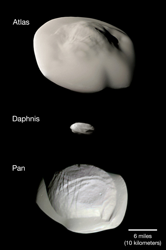
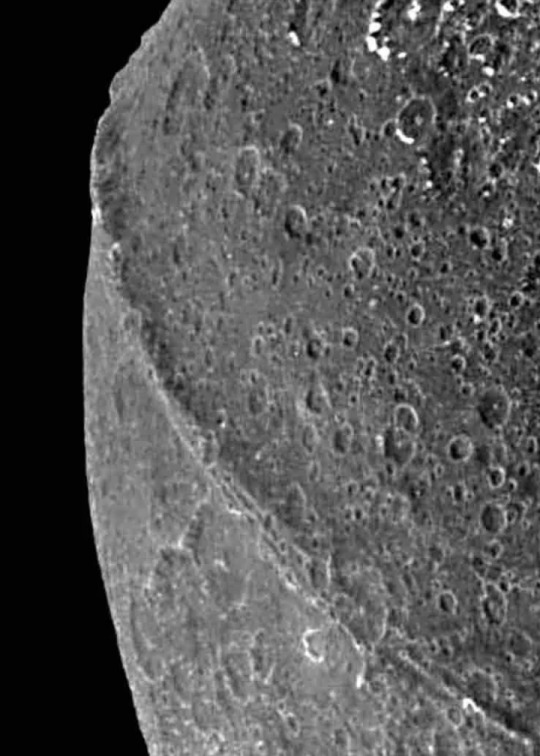
Explanation Explanation: Atlas, Daphnis, and Pan are small, inner, ring moons of Saturn. They are shown at the same scale in this montage of images by the Cassini spacecraft that made its grand final orbit of the ringed planet in September 2017. In fact, Daphnis was discovered in Cassini images from 2005. Atlas and Pan were first sighted in images from the Voyager 1 and 2 spacecraft. Flying saucer-shaped Atlas orbits near the outer edge of Saturn's bright A Ring while Daphnis orbits inside the A Ring's narrow Keeler Gap and Pan within the A Ring's larger Encke Gap. The curious equatorial ridges of the small ring moons could be built up by the accumulation of ring material over time. Even diminutive Daphnis makes waves in the ring material as it glides along the edge of the Keeler Gap.
#saturn planet#planet saturn#saturn#saturns rings#saturn says#astronomy#astronomers#universe#astrophotography#nasa#nasa photos#astrophysics#outer space#nasawebb#hubble space telescope#astrography#astronomy photography#astronews#astro notes#astronauts#planetary nebula#planet earth#planetary science#space science#science#scientific illustration#science facts#science photography#space photography#space program
78 notes
·
View notes
Text
This weekly column contains news stories and announcements from the American Redoubt area. The Inland Northwest is also a popular name for the region. Companies that are of interest to survivalists and preppers who live in the American Redoubt area will also be mentioned. We'll be discussing some unusually early snowfalls today.
Region-Wide
This article describes the legislative process that is required to make it happen: Two additional Oregon counties vote "yes" to Greater Idaho. However, ballot wins are far from moving borders.
o o o
KREM-2: Long-range winter forecast by Chief Meteorologist Jeremy LaGoo An excerpt:
" NOAA has released its 2022-2023 winter prediction. La Nina is back with lower than average equatorial Pacific seasurface temperatures. This means that the Northwest will experience a wetter and colder winter than usual. This forecast is not the same as previous winters.
Already, the atmospheric pattern that brings in more moisture and lower temperatures is present. The ridge that runs over the Pacific and the storm track that runs over the Northwest created the perfect conditions for some of the most significant snow seasons we have ever seen. Spokane already has more snow than last December, with more than 7 inches recorded so far this November.
Idaho
Idaho election results.
o o o
US approves a plan to open-pit mines of gold in Idaho.
o o o
Be careful...it may not be the trophy bull that you think it to.
o o o
Four University of Idaho Students were killed in a suspected homicide.
An update: University of Idaho Homicides: What you need to know about the victims allegedly murdered near campus.
Montana
Wildlife officials are still firm in their plan to allow Billings moose to 'leave on it'.
o o o
St. Police in Ignatius are looking for information about 2 thefts. JWR’s Comment: It seems that in Montana, like in coastal cities such as San Francisco, it is very serious to walk out of a grocery store with unpaid groceries.
o o o
Showdown Montana: "We're looking forward to a good, snowy Winter'.
Central & Eastern Oregon
Oregon Statewide Election Results.
o o o
Oregon's Measure 114 will take effect in 30 working days. This includes a ban for magazines that hold more than 10 rounds. Oregonians don't need me to remind them of the things they need to do...
o o o
Bend City Council will hold a public hearing. Consider adopting the camping code.
o o o
Homeless woman is arrested and suspected of arson.
Central & Eastern Washington
November 8, 2022 General Elections.
o o o
Spokane Cold Case solved by DNA Testing
o o o
A suspect was caught spray-painting a stolen truck in Kennewick.
o o o
Progress continues closing Camp Hope, as local and state agencies work together.
Wyoming
The first snow of the season.
o o o
Wyoming Election Results.
o o o
Map: Wyoming Businesses that Accept Goldbacks.
o o o
-4, Numerous Single Digit Temps Recorded In SE Wyoming.
Send your news tips
JWR would appreciate receiving news tips and announcements from the American Redoubt area, as well as information about American Redoubt-based businesses that are worthy of being mentioned. E-mail and our Contact form are both options.
0 notes
Text
Where Does Wind Come From?

The wind is the air moving as a result of the sun's unequal heating of the Earth. You cannot see it or touch it, and it lacks substantiality, but you can still sense its power. In the summer, it dries your clothing, and in the winter, it may be bone-chilling. It has the power to uproot enormous trees from the ground and drag sailing boats across the sea. It acts as the atmosphere's great equalizer, moving heat, moisture, pollution, and dust over vast distances.
Fluctuations in the pressure of the atmosphere produce winds. The sun heats the land and sea more than it does the rest of the world near the equator. Higher in the atmosphere, warm equatorial air moves to the poles. This system has little pressure. Simultaneously, cold, dense air replaces the hot air and flows over the surface of the Earth in the direction of the Equator. This system operates under high pressure. Winds move from high to low-pressure regions. There is a line called the front that separates these two regions. Different sorts of wind and weather patterns happen due to the complicated interactions between fronts.
Different types of winds
Prevailing air currents blow across a certain region from a single direction. Convergence zones are places where the main winds congregate. These winds often move east to west instead north to south. It occurs as a result of the Coriolis effect caused by the Earth's rotation. In the north half of the globe, the Coriolis effect causes wind systems to rotate counterclockwise, while in the south, clockwise.
Some winds move along the borders of the high and low-pressure processes due to the Coriolis effect. These are geostrophic winds that act by the following rule:
- In the north, when facing the wind with your back to it, low pressure will always be on your left. .
- Low-pressure systems in the south of the globe will be to your right.
Wind zones
Here are the five wind zones, including the westerlies, polar easterlies, trade wins, horse latitudes, and the doldrums:
1. Westerlies
The westerlies sometimes referred to as westerly winds, are present in two locations on Earth. They are between 30 and 60 degrees latitude in the Northern Hemisphere and between 30 and 60 degrees latitude in the Southern Hemisphere. The westerlies move west to east whereas other winds go east to west, giving these unusual winds their unusual names. In essence, as it warms, the air near the equator rises. The colder air at higher elevations goes to the aforementioned latitudes by this upward motion. In this upper latitudinal area, this circulating air also causes the air at lower altitudes to move. On the surface of the water, the speed difference between these two types of air may be sensed. On the earth's surface, you can feel the difference in speed between these two types of air.
Ocean currents are greatly influenced by westerlies, particularly in the south of the globe. The strong antarctic circumpolar current, propelled by westerlies, flows across the continent from the west region to the east at around 4 km per hour. This current is the world's greatest ocean current. It is in charge of bringing to the ocean vast quantities of cold water that is rich in nutrients. This water supports thriving marine ecosystems and food webs.
2. Polar Easterlies
Dry, chilly polar easterlies are the dominant winds from the east. They come from pressure ridges located around the South and North Poles. Low-pressure zones from sub-polar areas get polar easterlies.
3. Trade Winds
The powerful winds that move from the east over the tropics are trade winds. Typically, these winds are extremely predictable. They played a significant role in trade history, communication, and exploration. Trade winds allowed ships to quickly and reliably navigate the huge Atlantic and, subsequently, Pacific Oceans. They create sea currents that are still important for shipping today.
4. Horse Latitudes
Between the westerlies and the trade winds, there is a small region of warm, dry weather known as the horse latitudes. The latitudes of horses are roughly between 30 and 35 degrees north and south. The horse latitudes include several deserts, from the arid Kalahari of Africa to the dry Atacama of South America. At the horse latitudes, there are a variety of winds that are often weak. Even powerful winds frequently last only a few minutes.
5. Doldrums
The intertropical convergence zone(ITCZ) is the location where the trade winds from the two hemispheres converge. Doldrums surrounds the ITCZ. The weather is abnormally quiet, and there are faint breezes in the doldrums. The sun warms the equatorial region causing large air volume to grow and move south and north, resulting in the low-pressure doldrums. Around the horse latitudes, this warm, low-pressure equatorial wind descends once more. Some air masses circle in the opposite direction as westerlies, while others go back as trade wins to the doldrums.
https://youtu.be/ao_-OjDQwfk
Additional Resources:
Research on Wind
Stanford University Wind Energy Research
Read the full article
0 notes
Last Seen Blogs


standardworks43
StandardWorks 43|スタンダードワークス 43

nocturnalgifs
NOCTURNAL GIFS

s-c-g-s-c-g
S_C_G

im-really-tired-and-stupid
Silly Zone