#fra mauro
Text

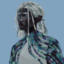
The EMU is entirely hollow and pieces can be removed, though this seems to agitate the entity. X-rays and spectrograph imaging have shown [REDACTED]-shaped outlines existing within the suit.
#control remedy#control game#control 2019#fra mauro#my art#fanart#artists on tumblr#control game fanart
485 notes
·
View notes
Text


59 notes
·
View notes
Text
I feel that Langston would eventually manage to decode Fra's sentences, if he was allowed to. Which Jesse would probably allow since she's more on the "figure out what the fuck all this is" side of things, in contrast to Darling's and Trench's "figure out how to control/eliminate all this"
Fra does make sense, you can understand what they're saying but their speech is... Sideways, in a sense. The meaning is almost there but the language is not completely understood by them so they use words that, when analyzed, relate to the meaning of the sentence as a whole, but sound like nonsense when you look at them face on. It's like trying to communicate via fragments of a dictionary, the words, when examined, form a coherent idea, but they're not being used correctly since Fra is learning human speech (and english, specifically) as they speak, and since the impatient jackasses of the Investigations Sector just locked them up, their learning most likely ground to a halt.
#control 2019#found this in my drafts#the Christmas Tree is also absolutely fascinating to me fro similar reasons#fra mauro#also this ties into my idea that all FBC personnel are Parautilitarians and/or Altered in some way which#whic is why they can even NOTICE and deal with all this shit in the first place
39 notes
·
View notes
Text
I am Minnesota. Pants are required.
13 notes
·
View notes
Text
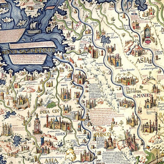
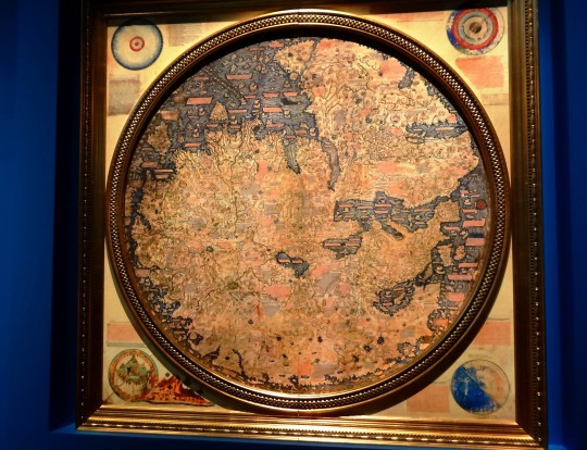
Mappa Mundi: The Greatest Medieval Map In The World
— By Anna Bressanin | Wednesday February 14, 2024
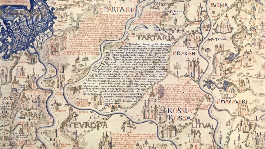
Credit: CalimaX/Alamy
From a small island in the Venetian lagoon, a 15th-Century monk somehow designed an astonishingly accurate planisphere of the world.
On the second floor of the Library of Saint Mark in Venice, a map of the world occupies an entire room – and rightfully so, considering its historical significance and imposing size (2.4m x 2.4m, bigger than a king size bed). Completed in 1459, the Mappa Mundi is the compendium of all the geographical knowledge of the time and is arguably the greatest medieval map of the world.
Almost twice as large as the famous English Hereford Mappa Mundi (ca 1300), this exquisitely decorated planisphere showcasing Europe, Africa and Asia was the masterpiece of Fra Mauro, a monk of the Camaldolese order who lived on the small Venetian island of San Michele.
Although the monk never set foot outside Venice, his Mappa Mundi is amazingly accurate in its depiction of cities, provinces, continents, rivers and mountains. America isn't on the map, since Christopher Columbus would take his trip across the ocean 33 years later; and nor is Australia. But Japan (or in Fra Mauro's words, "Cipango") is there, making its first appearance on a Western chart. Even more surprisingly, Africa is correctly drawn as circumnavigable, long before the Portuguese rounded the Cape of Good Hope in 1488.
"It's the oldest surviving medieval map," said Meredith Francesca Small, author of the book Here Begins the Dark Sea, also describing it as the most complete medieval map to survive into modernity. "It's the first map to be based on science more than religion. The Hereford map is all propaganda, religious propaganda."
While the Hereford map depicted Heaven and Hell and was designed to serve as a compendium of the world's knowledge from a spiritual perspective, Fra Mauro took a scientific approach to his cartography. He declared in his inscriptions that he would "verify the text by practical experience, investigating for many years and frequenting personas worthy of faith who have seen with their own eyes what I faithfully report here".
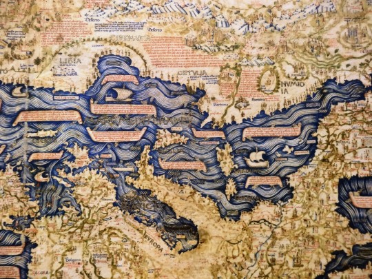
There's more than scientific and historical relevance to it, though. The most striking aspect of the map, which immediately catches your eye after ascending the white marble stairs of the Library of Saint Mark, where some of the world's most precious and ancient manuscripts are kept, is its sheer splendour.
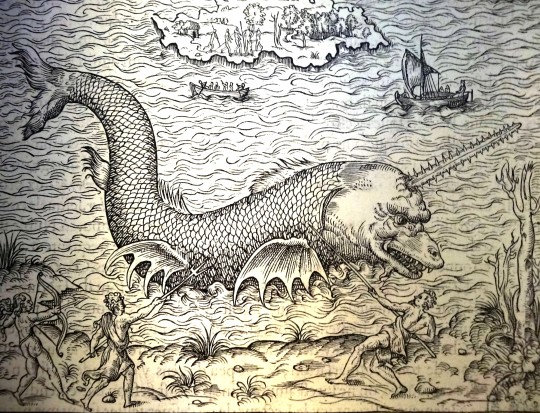
"It's huge, beautiful, fantastically crafted," said historian Pieralvise Zorzi. Beyond the outlines of countries and continents, Fra Mauro's Mappa Mundi is a magnificent golden and blue painting composed of minute drawings of gorgeous palaces, bridges, sailing ships, rolling blue waves and outsized sea creatures, plus a total of 3,000 cartigli – red and blue annotations written in ancient Venetian that tell stories, anecdotes and legends.
In Norway, for instance, a cartiglio indicates the location where the Venetian merchant Pietro Querini came ashore after a shipwreck. As the tale goes, he not only survived the accident, but he brought stockfish back home, thus starting the Venetian passion for baccalà (the creamy fish spread you can find in every osteria).

The Exquisitely Decorated Mappa Mundi measures an impressive 2.4m x 2.4m. Credit: Bildagentur-online/Getty Images
Another cartiglioindicates Tharse, the "kingdom where the Magi came from", then thought to be located somewhere between China and Mongolia.
All these annotations are legible on the map, and are relatively easy to decipher for Venetian speakers since the current dialect is not dramatically different from the idiom of the 15th Century. However, the inscriptions are also translated into English on an interactive map created by the Galileo Institute and Museum in Florence. Displayed on a flat screen in the same exhibition space as the Mappa Mundi, it provides the somewhat peculiar experience of entering the mind of a savant monk and reading the world through his medieval eyes.
It was not a small world. Although Fra Mauro lived his entire life in his island monastery in the lagoon backwaters, he tapped into the knowledge of travellers and merchants who crossed paths in the flourishing trading city of Venice that was "the capital of cartography at the time", explained Saint Marks librarian Margherita Venturelli.
“Maps Were Fundamental For Trade Because If You Have A Good Map, You Can Go Everywhere”
"Maps were fundamental for trade because if you have a good map, you can go everywhere," added Zorzi. "Every innovation in terms of cartography was welcome in Venice, and well-paid."

The Library of Saint Mark is home to one of the world's most significant collections of classical texts. Credit: Mo Peerbacus/Alamy
Fra Mauro's main source for Asia was merchant and fellow Venetian Marco Polo, who had published his travel accounts more than 150 years earlier. On the map, 150 locations are directly traceable to Marco Polo's Travels; for instance, the Mount of Adam was placed in the island of Ceylon (today's Sri Lanka), where, according to legends recounted by Polo, the first man's body was believed to be buried, together with his teeth and even his bowl, which was supposed to have the magical property of multiplying food.
Besides Polo, Fra Mauro had numerous sources around the globe. The fact that the chart looks upside down to contemporary Western eyes, with the south on top, might indicate that he was inspired by Arab cartography, like a 12th-Century map by North African geographer Muhammad al-Idrisi. The numbers that Fra Mauro lists as "the Distance of Heavens" are from mathematician and astronomer Campanus de Novara. "From the centre of the world to the surface of the Earth there are 3,245 miles. From the centre of the world to the lower surface of the heavens of the Moon there are 107,936 miles," and so on, he writes in the top left corner of the Mappa Mundi.
Fra Mauro also displayed a healthy scepticism and wasn't shy of criticising – as well as sometimes using –the revered Ptolemy's Geography, a treaty written in Alexandria, Egypt, by Claudius Ptolemy in 150 CE and lost for centuries to the Western world until it was rediscovered and translated in Latin again in the 1400s.
Fra Mauro's main source for Asia was merchant and fellow Venetian Marco Polo. Credit: The History Collection/Alamy
This Renaissance rationalist attitude also showed in the way he placed Adam and Eve in the Garden of Eden outside of the planisphere, making it clear that Heaven is not a place on Earth; a statement that separated religion and geography and was forward thinking for any medieval man, let alone a monk.
These novelties, and the fact that the map was completed few decades before Christopher Columbus sailed to America, contribute to Fra Mauro's Mappa Mundi being considered the geographical link between the Middle Ages and the Renaissance. To contemporary visitors, his map is a reminder of the fact that maps were once not only practical tools, but also a matter of beauty – and a way to tell the most extraordinary stories.
#Feature#History#Medieval Map#Mappa Mundi#BBC News 🗞️#Anna Bressanin#Venetian Marco Polo#Saint Mark#Library#Fra Mauro
2 notes
·
View notes
Photo


Je reviens ENCORE une fois à mon projet de présenter la plupart de mes 55800 photos (environ). On est en 2017 et comme ce blog est né en 2017, j’arriverai donc au bout de cette présentation.
Marseille en juillet. Au MuCEM, il y a l’expo “Aventuriers des Mers” :
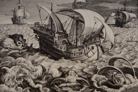
- André Thevet : “'Le Vlétif" - France,1575
- Adriaen Collaert : “Monstres Marins" - Anvers, 1595
- Rashid Al-Din : “Jonas et la Baleine" - Tabriz,1314
- Fra Mauro - mappemonde - Venise, 1459 (oui, elle est “à l’envers”)
- id
- Théodore de Bry : “Crabes Géants" - Francfort,1598
- mappemonde - Catalogne,1450
#souvenirs#marseille#expo#MuCEM#aventuriers des mers#monstre#monstre marin#vlétif#renaissance#andré thevet#adriaen collaert#flandres#anvers#rashid al-din#jonas#baleine#tabriz#perse#fra mauro#venise#mappemonde#théodore de bry#crabe#francfort#allemagne#catalogne
3 notes
·
View notes
Text
With the Oldest House shut off from the outside and most of the employees dead from the Hiss, they’re going to have to start promoting people into new positions. Imagine the Oldest House finally opening after the lockdown and their field agents come back to the Fra Mauro entity as head of communications
#look they don’t have a big pool of potential hires in what remains of the Hiss incident..#saying all of this just because I want that fra mauro astronaut to return#control 2019#control remedy#spider time!
62 notes
·
View notes
Text
anyway, to start the essay, I do not think we have ever interacted with the "real" Thomas Zane, and *the giant parade float deer crashes down on Alan's skull, killing us instantly*
#alan wake#i'm actually good at this game it just takes a moment to remember how to time the dodges fhghsh#but anyway. something something never seeing his face and fra mauro + diver suit and james mccaffrey's voice for zane and casey. etc#remedy posting#*posts
34 notes
·
View notes
Text
"kill them with kindness" WRONG. seemingly affect their memory to make your presence feel unremarkable🌑🚀🌑🚀🌑🚀🌑🚀🌑🚀🌑🚀🌑🚀🌑🚀🌑🚀🌑🚀🌑🚀🌑🚀🌑🚀🌑🚀🌑🚀🌑🚀🌑🚀🌑🚀🌑🚀🌑🚀🌑🚀🌑🚀🌑🚀🌑🚀🌑🚀🌑🚀🌑🚀
2 notes
·
View notes
Text
The original Moon landing sites
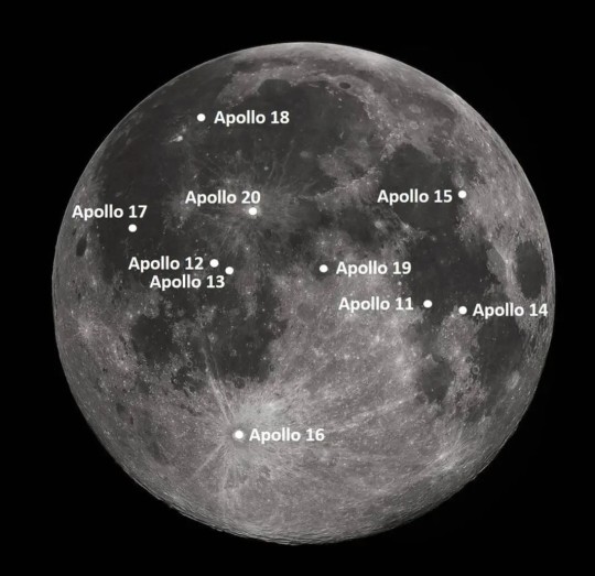
"NASA contracted to have 15 flight-worthy Saturn V rockets produced. Apollo 11 achieved the first landing with the sixth Saturn V, leaving nine for follow-on landings. The following landing sites were chosen for these missions, planned to occur at intervals of approximately four months through July 1972."
Note: I've updated this list with the original tentative planned launch dates.
G-type Mission
Apollo 11: (G) Mare Tranquillitatis, July 1969
H-type missions
Apollo 12: (H1) Ocean of Storms (Surveyor 3 site), November 1969
Apollo 13: (H2) Fra Mauro Highlands, March 1970
Apollo 14: (H3) Littrow Crater, July 1970
Apollo 15: (H4) Censorinus Crater, November 1970
J-type missions, the extended stay missions
Apollo 16: (J1) Descartes Highlands or Tycho Crater (Surveyor 7 site), April 1971
Apollo 17: (J2) Marius Hills or Marius Hills volcanic domes, September 1971
Apollo 18: (J3) Copernicus crater or Schröter's Valley or Gassendi crater, February 1972, later July 1973
Apollo 19: (J4) Hadley Rille, July 1972, later December 1973
Apollo 20: (J5) Tycho Crater or Copernicus Crater or Marius Hills, December 1972, later July 1974
As we all know, plans were changed and missions were cancelled. But it's nice to see what was initially planned.
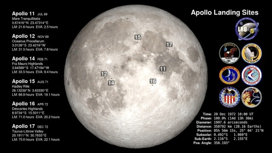
To compare with the actual landing sites and dates:
Apollo 12: (H1) Ocean of Storms (Surveyor 3 site), November 1969
Apollo 13: (H2) never landed, April 1970
Apollo 14: (H3) Fra Mauro, January-February 1971
Apollo 15: (J1) Hadley–Apennine, July-August 1971
Apollo 16: (J2) Descartes Highlands, April 1972
Apollo 17: (J3) Taurus–Littrow, December 1972
NASA ID: link, link
Information from Astronautix: link
Information from Wikipedia: link
#Apollo 11#Apollo 12#Apollo 13#Apollo 14#Apollo 15#Apollo 16#Apollo 17#Apollo 18#Apollo 19#Apollo 20#NASA#Apollo Program#Moon#Moon landing#Lunar Module#cancelled#G-type Mission#H-type mission#J-type mission#Cancelled Mission#my post
436 notes
·
View notes
Photo

2.4 x 2.4 meters, Fra Mauro's mappa mundi: the world's largest extant map from early modern Europe, 1450.
201 notes
·
View notes
Photo
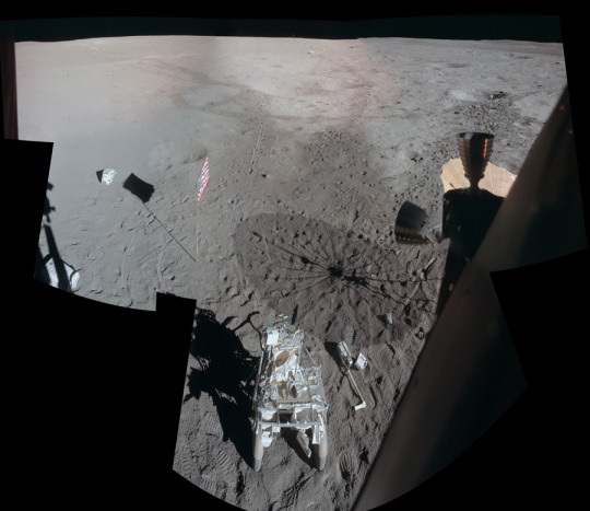
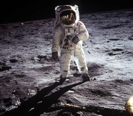
2024 February 3
Apollo 14: A View from Antares
Image Credit: Edgar Mitchell, Apollo 14, NASA; Mosaic - Eric M. Jones
Explanation: Apollo 14's Lunar Module Antares landed on the Moon on February 5, 1971. Toward the end of the stay astronaut Ed Mitchell snapped a series of photos of the lunar surface while looking out a window, assembled into this detailed mosaic by Apollo Lunar Surface Journal editor Eric Jones. The view looks across the Fra Mauro highlands to the northwest of the landing site after the Apollo 14 astronauts had completed their second and final walk on the Moon. Prominent in the foreground is their Modular Equipment Transporter, a two-wheeled, rickshaw-like device used to carry tools and samples. Near the horizon at top center is a 1.5 meter wide boulder dubbed Turtle rock. In the shallow crater below Turtle rock is the long white handle of a sampling instrument, thrown there javelin-style by Mitchell. Mitchell's fellow moonwalker and first American in space, Alan Shepard, also used a makeshift six iron to hit two golf balls. One of Shepard's golf balls is just visible as a white spot below Mitchell's javelin.
∞ Source: apod.nasa.gov/apod/ap240203.html
82 notes
·
View notes
Text
song 23 in my 30 song series of songs named after prominent named craters on the near side of the moon songs
258 notes
·
View notes
Text
DO SHADOWS APPEAR ON THE MOON'S SURFACE??
Blog#325
Wednesday, August 23rd, 2023
Welcome back,
The moon is utterly familiar. We see it all the time, in the blue sky during the day, among the stars and planets at night. Every child knows the outlines of the moon’s lava seas: they trace the Man in the Moon or, sometimes, a Rabbit.
This familiarity goes beyond appearances. The moon is actually made of Earth. According to modern theories, the moon was born some 4.5 billion years ago when an oversized asteroid struck our planet. Material from Earth itself spun out into space and coalesced into our giant satellite.
Yet when Apollo astronauts stepped out onto this familiar piece of home, they discovered that it only seems familiar. From the electrically-charged dust at their feet to the inky-black skies above, the moon they explored was utterly alien.
On the next sunny day, step outdoors and look inside your shadow. It’s not very dark, is it? Grass, sidewalk, toes–whatever’s in there, you can see quite well.
Your shadow’s inner light comes from the sky. Molecules in Earth’s atmosphere scatter sunlight (blue more than red) in all directions, and some of that light lands in your shadow. Look at your shadowed footprints on fresh sunlit snow: they are blue!
Without the blue sky, your shadow would be eerily dark, like a piece of night following you around. Weird. Yet that’s exactly how it is on the Moon.
To visualize the experience of Apollo astronauts, imagine the sky turning completely and utterly black while the sun continues to glare.
Your silhouette darkens, telling you “you’re not on Earth anymore.”
Shadows were one of the first things Apollo 11 astronaut Neil Armstrong mentioned when he stepped onto the surface of the moon. “It’s quite dark here in the shadow [of the lunar module] and a little hard for me to see that I have good footing,” he radioed to Earth.
The Eagle had touched down on the Sea of Tranquility with its external equipment locker, a stowage compartment called “MESA,” in the shadow of the spacecraft.
Although the sun was blazing down around them, Armstrong and Buzz Aldrin had to work in the dark to deploy their TV camera and various geology tools.
“It is very easy to see in the shadows after you adapt for a while,” noted Armstrong. But, added Aldrin, “continually moving back and forth from sunlight to shadow should be avoided because it’s going to cost you some time in perception ability.”
Truly, moon shadows aren’t absolutely black. Sunlight reflected from the moon’s gently rounded terrain provides some feeble illumination, as does the Earth itself, which is a secondary source of light in lunar skies. Given plenty of time to adapt, an astronaut could see almost anywhere.
Almost. Consider the experience of Apollo 14 astronauts Al Shepard and Ed Mitchell:
They had just landed at Fra Mauro and were busily unloading the lunar module. Out came the ALSEP, a group of experiments bolted to a pallet. Items on the pallet were held down by “Boyd bolts,” each bolt recessed in a sleeve used to guide the Universal Handling Tool, a sort of astronaut’s wrench. Shepard would insert the tool and give it a twist to release the bolt–simple, except that the sleeves quickly filled with moondust. The tool wouldn’t go all the way in.
The sleeve made its own little shadow, so “Al was looking at it, trying to see inside. And he couldn’t get the tool in and couldn’t get it released–and he couldn’t see it,” recalls Mitchell.
“Remember,” adds Mitchell, “on the lunar surface there’s no air to refract light–so unless you’ve got direct sunlight, there’s no way in hell you can see anything. It was just pitch black. That’s an amazing phenomenon on an airleuss planet.”
(Eventually they solved the problem by turning the entire pallet upside down and shaking loose the moondust. Some of the Boyd bolts, loosened better than they thought, rained down as well.)
Originally published on universetoday.com
COMING UP!!
(Saturday, August 26th, 2023)
"WHAT IS THE GREAT SILENCE??"
#astronomy#outer space#alternate universe#astrophysics#universe#spacecraft#white universe#parallel universe#space#astrophotography
73 notes
·
View notes
Text
Some days, I sit here in my containment chamber, and I wonder what the point of it all is. Granted, this place is Heaven compared to the perpetual boredom of the moon, and the Bureau has been treating me far better since Jessie took over. But at the end of the day, I’m still trapped in this cramped, sterile environment, hidden away from the world so that I don’t “upset the world’s standard of normalcy”. The world beyond is so full of beauty and wonder, forever out of reach in my cell, in a mostly forgotten sector of an office building.
It wouldn’t be so frustrating if it weren’t for the language barrier. I try so desperately to communicate with those around me just to have my simplest needs met, only to be met with confusion and annoyance. Most people just see me as “that goofy spacesuit who doesn’t word right, lol”. If it weren’t for the kindness and empathy of people like Jessie, Langston, and Emily, I would have succumbed to despair years ago.
Don’t get me wrong. My life is better here than it was on the moon. But am I truly living, or am I merely surviving?
Spider time...
17 notes
·
View notes
Photo

Part of sheet 2 of the Apollo Mission 17 Lunar Photography Index map. This map provides a spatial index of the strips of large format black and white images that were taken by the 610 mm focal length ITEK panoramic camera used on the mission. The high-resolution panoramic photographs were recorded in stereoscopic and monoscopic modes. The orbital altitude for the panoramic images was 111 kilometers above the moon's surface.
One of the lasting legacies of the Apollo missions is the huge archive of high quality photographic images - over 30,000 in total. Apollo missions 15,16 and 17 deployed a high quality Panoramic camera, that could obtain pictures of narrow strips of the Moons surface as the service module orbited the Moon. At the scale of the Moon's surface, these images were 20 kilometers wide and nearly 320 kilometers long, with high resolution that could be used to identify features down to about 2 meters in size. During Apollo 17, the panoramic camera was used on nine orbits and obtained nearly 1600 usable images.
The Panoramic camera automatically recorded images, but the Apollo 17 crewmen could intervene to control the camera power and operational modes. The film cartridges were retrieved from the external location.
The image shown here is part of an index map, on which the locations of the image strips were plotted. This index map shows the Moon's surface close to the crater Copernicus (which can be seen on a clear night from the Earth using binoculars). The crater is located slightly left of and above 20° W, 10° N, which is at the centre of the side of the Moon that faces the Earth. Further south is the Mare Cognitum (literally the Sea that has become known). Several spacecraft have landed on, or near to, Mare Cognitum, including; Luna 5, Ranger 7, Surveyor 3, and Apollo 12. The landing site of Apollo 14, the Fra Mauro formation, is also close to Mare Cognitum.
Many of the features on the surface of the moon are named after pioneering astronomers or optical scientists. These names are not well known outside of astronomy, but when the names of these pioneers are collected together they form surprisingly lyrical stanzas;
Kepler, Flamsteed, Wolf.Marius, Milichius.Lalander, Loewy. Gassendi, Euclides.Gambart, Lippershey, Kies.
In the the early 1990's the American landscape photographer Michael Light obtained permission from NASA to work with the archive of original photographic negatives from all of their Moon missions. The result of this collaboration included the publication of a book by Light called Full Moon in 1999. This was his imagined photographic narrative of a single Moon mission created by composite. Light also created very large digital prints from the images and made a travelling exhibition of them. A selection of these prints are on permanent exhibit at the America Museum of Natural History in New York.
via datedeluge
157 notes
·
View notes
Last Seen Blogs

cakebankss
Untitled

urdanic
Lactuca sativa

lxdymormont
then, child, make another

smokenpoke
Untitled
lainalit
Alina