#South Aegean
Text


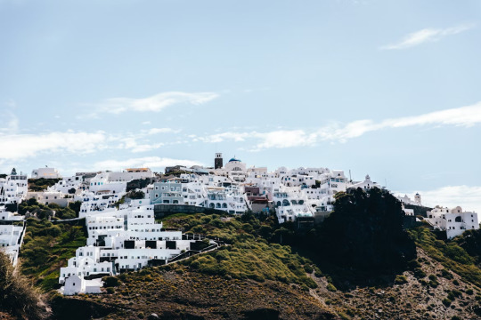
S a n t o r i n i
#santorini#cyclades#aegean#islands#islas#south aegean#aegean islands#aegean sea#mar egeo#greece#grecia#europe#europa
188 notes
·
View notes
Text
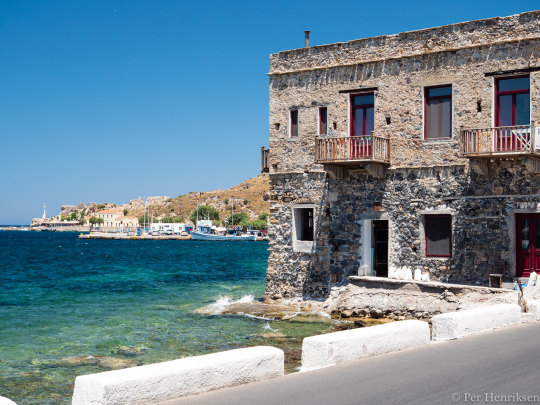


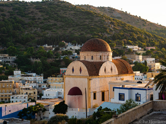
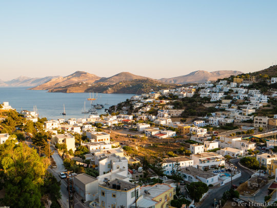
Leros 2019 (2) (3) (4) (5) by Per Henriksen
Via Flickr:
Picture taken in 2019 on the island of Leros, Greece with a Panasonic G9 (mostly).
#ocean#waterfront#buildings#stairs#beach#rocky shore#incidental person#windmill#bay#wide sky#greece#south aegean#kalymnos
10 notes
·
View notes
Text


Santorini, South Aegean Region, Greece
Andre Benz
3 notes
·
View notes
Text
Island Hopping - Santorini Part 2
Island Hopping – Santorini Part 2
The done thing on Santorini is to put the caldera in your eyeholes from every available angle. It’s a volcanic island, there’s volcanic craters on an island in the middle of the vast bay, and the shape of the bay itself was caused by a whopping great eruption, and that’s the flooded caldera you’ve come here to see.
If you can so much as glimpse this fucker in your peripheral, expect your beer to…

View On WordPress
#Backpacking#Cyclades#Europe#Greece#Greece 2022#Island Hopping#Santorini#Santorini Caldera Tour#South Aegean#Travel#Volcano Tour#Wanderlust
0 notes
Text
#www.triptocrete.com#The largest island in Greece#Crete is renowned for its pin-up beaches#wild natural beauty#exquisite cuisine and thousands of years of culture and history#As Crete’s most celebrated author#Nikos Kazantzakis (of Zorba the Greek fame)#once wrote: “The mystery of Crete runs deep. Whoever sets foot on this island senses a mysterious force coursing warmly and beneficently th#sensing their soul beginning to grow.”#Unsurprisingly#this mystical#pure and generous island to the south of the Aegean Sea captures the spirit of Greece and enchants everyone who visits.#Heraklion#Rethymno#Chania#Agios Nikolaos#Elounda#Ierapetra#Malia#Hersonissos#Sitia#Sfakia… wherever you visit#it’s an island of thousands of vibrant images#filled with an open-hearted and vivacious spirit#rich history#world-famous cuisine and hospitable people.#crete#greece#travel#chania
2 notes
·
View notes
Photo

Astyplaia, South Aegean - Greece
743 notes
·
View notes
Photo
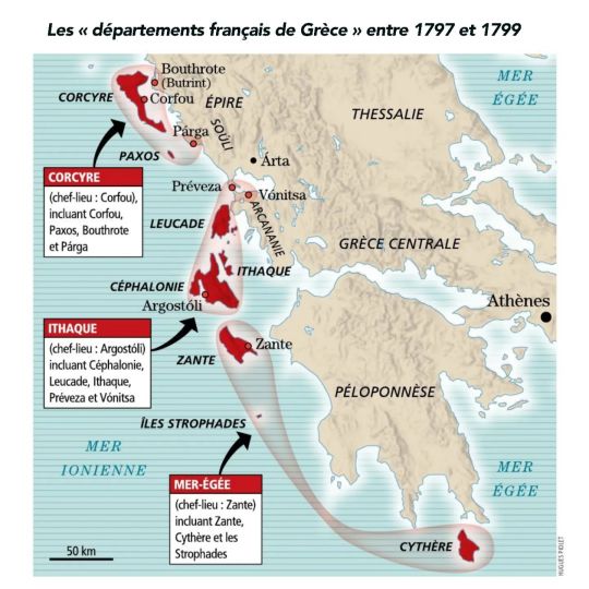
The Ionian Islands or “French departments of Greece” between June 1797 and March 1799
Revue « Historia » n°925, janvier 2024
by cartesdhistoire
By the Treaty of Campoformio (October 17, 1797), France acquired the formerly Venetian islands of the Lonian Sea, strategic bases which will help France to participate in the sharing, which is believed to be imminent, of the spoils of the Ottoman Empire: north to south, Corfu, Paxos, Lefkada, Ithaca, Kefalonia, Zante, plus Cythera to the south of the Peloponnese, and the numerous islets that separate them. Added to this are the Venetian establishments on the coast of Epirus: Párga, Arta, Préveza and Bouthrote.
It was Bonaparte himself who, by a letter to the Directory of 25 Brumaire Year VI (November 15, 1797), provided for the organization of these new French departments of Greece, three in number: Corcyra (with the capital of city of Corfu), Ithaca (with Argostóli as its capital) and Aegean Sea (with Zante, its capital, Cythera – the medieval Cerigo – and the quasi-desert archipelago of Strophades).
The French established a foothold in Kefalonia on June 28 and in Corfu on the 29th. The jurist Pierre–Jacques Bonhomme de Comeyras was responsible for administering the three departments from Corfu, as commissioner of the Directory. Provisional municipalities, with local notables known to be Francophiles, were set up as well as a departmental direction called the “Central”, not to mention, in parallel, a military administration, trying above all to control the French troops so that they did not does not behave like an army of occupation.
But, as part of the War of the Second Coalition, an offensive by the Russian fleet, acting on behalf of the Ottomans, took place from October 12, 1798 (battle of Nicopolis and capture of Préveza). Then followed, in order, the captures of Cythera, Zante, Ithaca, Kefalonia and Lefkada until November 27. Besieged Corfu resisted from November 18, 1798 to March 3, 1799.
In March 1800, the archipelago became the Republic of the Seven Islands, under the nominal authority of the Porte but under that, in reality, of Russian forces.
50 notes
·
View notes
Text
Мнемиопсис - древнейший, люминесцентный организм.
Mnemiopsis is an ancient, luminescent organism.


Гребневики не являются медузой, даже не имеют с ними родственных связей, хотя называть их по другому не в��ходит. Внешне мнемиопсисы легкие, прозрачные, с юбочками-лопастями и гребными пластинами. У них нет мозга, сердца, скелета, зато есть нервная система, орган равновесия и способность к люминесценции. Мнемиопсис – хищник, это плотоядное животное питающийся зоопланктоном, икринками, личинками рыб и моллюсков. На свету переливается яркими цветами, ночью придает морским волнам желтоватое люминисцентное свечение.
По самым последним данным ученых гребневик является одним из первых живых созданий на планете Земля. Ранее считалось, что этот титул принадлежит морским губкам — гораздо более примитивным существам.
Совсем недавно Гребневик Мнемиопсис (Mnemiopsis leidyi) – обитал лишь по ту сторону океана: вдоль восточного побережья Северной и Южной Америки, от Канады до Аргентины. Но, благодаря интенсивному судоходству, вместе с балластными водами он перебрался и в Европу. Как оказалось, гребневик может приспосабливаться к большому диапазону солёности. Теперь его ареал обитания включает Чёрное море, Азовское, Эгейское и Мраморное моря, западное побережье Швеции, даже почти пресное Балтийское море .
Ctenophores are not jellyfish, and they are not even related to them, although it is impossible to call them anything else. Externally, Mnemiopsis are light, transparent, with blade-like skirts and paddle plates. They do not have a brain, heart, or skeleton, but they do have a nervous system, an organ of balance, and the ability to luminesce. Mnemiopsis is a predator, a carnivore that feeds on zooplankton, eggs, and larvae of fish and mollusks. In the light it shimmers with bright colors, at night it gives the sea waves a yellowish luminescent glow.
According to the latest data from scientists, the ctenophore is one of the first living creatures on planet Earth. Previously it was believed that this title belongs to sea sponges - much more primitive creatures. More recently, the Ctenophore Mnemiopsis (Mnemiopsis leidyi) lived only on the other side of the ocean: along the eastern coast of North and South America, from Canada to Argentina. But, thanks to intensive shipping, it moved to Europe along with ballast waters. As it turns out, the ctenophore can adapt to a wide range of salinity. Now its habitat includes the Black Sea, the Azov, Aegean and Marmara Seas, the western coast of Sweden, even the almost fresh Baltic Sea.
Источник: telegram Океан,
nplus1.ru/news/2020/05/08/mnemiopsis,
/www.nkj.ru/archive/articles/23340/, /pikabu.ru/story/mnemiopsis__chuma_xxi_veka_4346622,/turizm.pibig.info/19015-grebnevik-v-chernom-more-mnemiopsis.html,
/ezoteriker.ru/grebnevik-beroe-v-chernom-more-mnemiopsis-chuma-hhi-veka-9-foto-mnemiopsis/,
//spadilo.ru/grebneviki-meduzy-ili-polipy/,
/dzen.ru/a/YbGQswZ7Y0VAg-7O,
/myanapa.ru/fauna/invertebrates/grebnevik/,
//seaforum.aqualogo.ru/topic/54177-гребневик-мнемиопсис-mnemiopsis-leidyi/.
#fauna#video#animal video#marine life#marine biology#nature#aquatic animals#sea creatures#Ctenophores#Mnemiopsis#luminesce#sea view#sea#beautiful#animal photography#nature aesthetic#animal gif#видео#фауна#природнаякрасота#природа#море#Гребневик#Мнемиопсис#люминесценция#планктон#гиф
65 notes
·
View notes
Photo
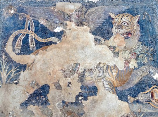
A Hellenistic Greek mosaic depicting the god Dionysos as a winged daimon riding on a tiger, from the House of Dionysos at Delos (which was once controlled by Athens) in the South Aegean region of Greece, late 2nd century BCE, Archaeological Museum of Delos. [Robert Scott Horton]
* * * *
“Cultivating loyalty is no small thing. George Orwell, for example, considered preferential loyalty to be the “essence of being human.” Critiquing Gandhi’s recommendation — that we must have no close friendships or exclusive loves because these will introduce loyalty and favoritism, preventing us from loving everyone equally — Orwell retorted that “the essence of being human is that one does not seek perfection, that one is sometimes willing to commit sins for the sake of loyalty … and that one is prepared in the end to be defeated and broken up by life, which is the inevitable price of fastening one’s love upon other human individuals.”
— The Myth of Universal Love - NYTimes.com
[Quidnunc: Friendship]
#Hellenistic Greek mosaic#Dionysos#a winged daimon riding a tiger#2nd century BCE#Robert Scott Horton#loyalty#friendship#The Myth of Universal Love#quidnunc
76 notes
·
View notes
Text

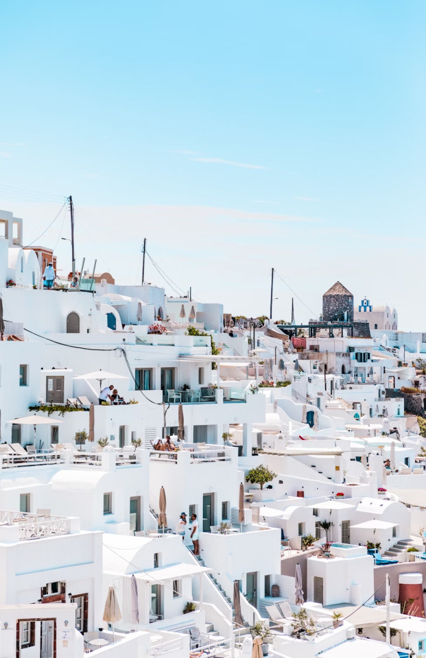
S A N T O R I N I
#santorini#cyclades#south aegean#aegean islands#aegean sea#mar egeo#islas#greece#grecia#europe#europa
179 notes
·
View notes
Text
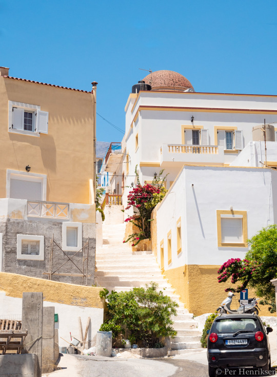
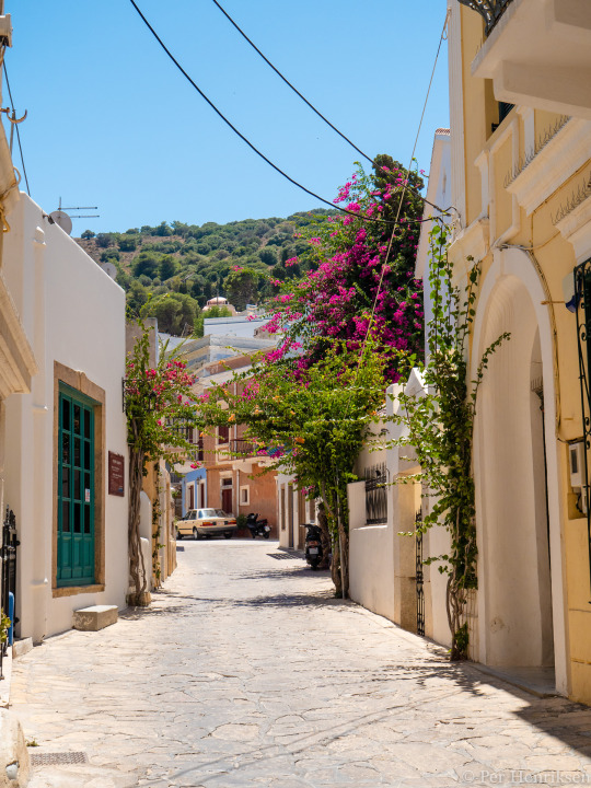

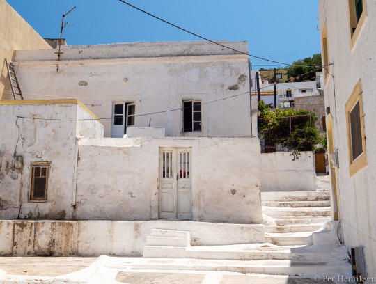
Leros 2019 (2) (3) (4) (5) by Per Henriksen
Via Flickr:
Picture taken in 2019 on the island of Leros, Greece with a Panasonic G9 (mostly).
#around the neighborhood#roaming the streets#flowers#stairs#mountains#city overview#golden light#greece#south aegean#kalymnos
7 notes
·
View notes
Text

Village square
Melnik, Bulgaria
Melnik is a small town in southwest Bulgaria in the Pirin Mountains where the soft sandstone reveals eroded faces. The town dates from the 12th century CE and grew to over 25,000 inhabitants before the Balkan Wars when the majority of structures were destroyed. There is a Byzantine ruin within the town but the present surviving historic dwellings date from the 18th to the early 20th century when the area was under Ottoman control. The town formed along the Rožen streambed and Melnik River that flows south into the Struma river and eventually into the Strymonian Gulf of the Aegean Sea. (photo 1994)
21 notes
·
View notes
Text
Island Hopping - Santorini Part 1
Island Hopping – Santorini Part 1
It’s like you can’t have a really good experience on an island without it then being counteracted by the next. Santor-fucking-rini, honestly, what the actual fuck? We’d intended to stay at the campsite in Fira but the reviews were crap and we still had that shithole on Paros on our minds. So we went wayyyyy overbudget to book ourselves a room on Booking.com which, in hindsight, was a whole…

View On WordPress
#Adventure#Backpacking#Europe#Greece#Greece 2022#Island Hopping#Santorini#South Aegean#Travel#Wanderlust
0 notes
Text
someone posted a picture of a map and captioned it: The oldest Ptolemy map of Palestine is dated 150 AD. The large red letters in the center say in Greek: Παλαιστινης or Palaistinis.
Map in question:
What's accurate: all of it. This is a Byzantine Greek copy of Ptolemy's 4th Asia map from the Codex Vaticanus Urbinas Graecus 82, Constantinople c. 1300. It was probably assembled by Maximus Planudes.
it seems like this post is some kind of 'gotcha' to prove that Palestine as a name/entity has existed for thousands of years, which it has. This is beyond dispute. The name Palestine is (probably) derived from Peleset, who you might know as the Sea People, who were from the Aegean. after they had fun times (not fun times) with Ramesses III, they relocated to the southern coast of Canaan, intermarried with the Canaanites, and became known as the Philistines. The Assyrians called that regions 'Palas(h)tu' since 800 BC; the term Palestine as "Palestine" first appeared in Herodotus' Histories in the 5th century BC, and this usage continued with other Greek and Roman writers (Aristotle, Ovid, Pliny the Elder, etc.). the term Syria Palaestina (literally Palestinian Syria) was used to refer to the Roman province which was created in the 2nd century AD. this is the name we see in the map above. cool.
What's missing: the Roman province Syria Palaestina was created by incorporating the province of Judaea and surrounding areas after they were defeated by the Romans in the Bar Kokhba revolt in 135 AD (the end of the third Roman-Jewish Wars). to put a button on the issue, removing the name Judaea is commonly believed to have been a 'fuck you, we won' - as in, the name change from Judaea to Syria Palestina was done to "sever the connection of the Jews to their historical homeland".
furthermore: Judaea had been a Roman province since 6 AD and the name Judaea was a Latinized version of Judah, a kingdom founded in approximately 930 BC, that bordered the Philistine City States, as in Philistia, mentioned above. They were BOTH there. They were there concurrently with the Kingdom of Israel (Samaria). Look at this map! They are RIGHT next to each other at the SAME period in time, directly south of the kingdom of, guess who, Israel (also founded approximately 930 BC).
like damn. this is the most contentious topic on earth right now. try to provide some context to whatever historical stuff you post on this hellsite before a bunch of people (smart people! people I know and respect!) see it and share it without having a clue about the context because they aren't inclined to do any further digging and it fits with the narrative they most agree with.
#there is really nothing I hate more than historical misinformation to prove a point. even/ESPECIALLY if it's a point I agree with#stop making the worst point ever to “win” an argument. all you are doing is losing the argument and the respect of me and those around you.#also. you do not (and I mean this) you DO NOT need to use the ROMAN EMPIRE as proof that your claim to existence is legitimate oh my god#if historical irredentism is gonna be based on Roman provincial names Greece Egypt Tunisia and Italy are about to EXPLODE
7 notes
·
View notes
Note
I know this is obnoxious and very nitpicky but athens is neither the hottest nor the driest place in greece lmao, parts of the Cyclades islands are the driest by far and as for the hottest, if you consider highest temperatures in the summer or the summer average highest temperature a good pick would be sparta/southern peloponese in general or if you consider the yearly average temperature then it would be a southern Dodecanese island maybe kastelorizo, or southern crete and gavdos due to the very mild winters
Sincerely a person who spents way too much time on wikipedia
See, while a lot of this should make sense, it is not exactly correct. South doesn't always equate hotter and drier. Besides, I was not talking about annual averages, as I was saying Athens is not good for summer in specific.
Regarding Athens versus Sparta - Athens has higher average highs for summer (though Sparta is pretty hot too) and Sparta has more precipitation than Athens throughout the year and also a little more in the summer as well. The differences are small but the conclusion is the same: Athens is hotter and drier than Sparta in the far-south. Here are the full climate reports for Athens and Sparta from the same website to avoid scewed data. In case you are wondering why, it's probably because Sparta is built on the foot of Mt Taygetus, which brings it a little more rainfall and coolness. Athens has Parnitha but it is a smaller mountain. Athens also dried up and built over all its rivers, turning its once semi-humid microclimate to a very dry one. All these things affect the real and even more so the felt weather. If you add to that the extreme urbanisation of Athens, the gasses produced by the traffic and its alarming lack in vegetation, it makes summer there an extremely difficult business.
As for the islands, the south of Athens' region (and a bit of Corinth next to it) are the only mainland regions which belong to the same hot semi-arid zone as the Cycladic islands you mentioned. I can't tell you which of all these places is the absolute hottest and driest without looking it up, but some of Attica belongs to that zone and the part that doesn't has all the aforementioned conditions that make the felt climate very similar. Furthermore, I was also talking about main destinations - if there is somewhere a village of 10 people that is hotter and drier than Athens, well, I might have not taken it into account in my travel guide post lol
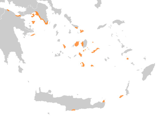
The map is from the Wikipedia page “Climate of Greece”. In orange is the hot semi-arid zone.
Then I searched Kastelorizo island in the Dodecanese and Elounda in South Crete; both of those are colder in the summer than Athens, with an average high 2-3 degrees below Athens, although they are drier (like, 2 days of rain in Elounda versus 4 days of rain in Athens). Search them up in the same website. (Kastelorizo is with the name "Megisti".)
It is not a mystery that those islands have lower average highs than Athens, because they have something Athens lacks. They are surrounded by the sea, which always makes the climate milder and they have much stronger winds, the Aegean sea breezes. For example, when travelling to the Cyclades, you will need to have a jacket with you for the evenings. If you put a jacket in Athens in July, it's probably a suicide attempt.
See, there's a lot of stuff that makes environmental conditions what they are. I can confidently repeat that the summer heatwave in Athens - both in terms of numbers and experience - will be more unpleasant than in Gavdos or any other arid southern island.
Fun fact: Wanna know another place that gets extreme highs, more than Sparta and most of these islands we mentioned, and is the true heat archenemy of Athens?
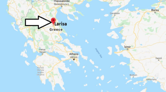
And Lamia too, which is between Larisa and Athens. But those are clearly more humid and rainy than Athens so.. 🤷🏻♀️ (I didn’t edit the map with the arrow btw, it was like that on its own and for some reason I find this very funny.)
8 notes
·
View notes
Photo
Astyplaia, South Aegean - Greece
110 notes
·
View notes
Last Seen Blogs