
Last Seen Blogs

heartvisor
Ψ(メ▼∇▼)Ψ

fullleatherartillery-blog1
fullleatherartillery

blogfurniture
nội thất nhà đẹp


hungryyindiann-blog
hungryy.indiann
Text
SkyDrive and KEPCO Partner to Develop Electric Charging Infrastructure for eVTOLs

SkyDrive Inc. (“SkyDrive”), a prominent Japanese manufacturer of eVTOL aircraft, has joined forces with the Kansai Electric Power Company (“KEPCO”) to develop electric charging infrastructure for eVTOLs. These facilities will be deployed in Osaka, Kansai, in preparation for the World EXPO 2025.
SkyDrive, with its vision of leading the mobility revolution of our time, is focused on creating an affordable eVTOL aircraft designed for everyday mass transportation. The company has been chosen to participate in the “Smart Mobility Expo” Project under the Advanced Air Mobility category at Expo 2025 Osaka, Kansai, where it will showcase its “SKYDRIVE” eVTOL aircraft. KEPCO, on the other hand, specializes in developing charging facilities for eVTOLs and exploring the installation of electric power infrastructure at eVTOL vertiports with a potential entry into the charging infrastructure sector.
In 2022, SkyDrive initiated a capital and business alliance with KEPCO, which led to collaborative efforts in researching and developing advanced charging facilities essential for the practical integration of eVTOLs into daily life. These facilities allow for rapid charging with high current and voltage, ensuring minimal turnaround times and cost-effective operations. Moreover, their design supports scalability, facilitating broader global applications.
The initial charging facilities are set to be installed at the Flight Test Facility by the end of this year to support ongoing flight tests. Subsequently, another facility will be established at the eVTOL vertiport on Yumeshima Island for the EXPO 2025 Osaka, Kansai.
SkyDrive and KEPCO maintain their commitment to close collaboration, aiming to successfully introduce eVTOL technology in Japan and around the world.
About SkyDrive Inc.
Founded in July 2018, SkyDrive emerged after years of testing flying car concepts and prototypes. Their mission is to lead the mobility revolution of our era, making eVTOLs accessible for daily transportation in Japan and beyond. In 2019, SkyDrive achieved the first crewed eVTOL flight test in Japan, and their eVTOL model, “SKYDRIVE,” is in the process of acquiring Japan Civil Aviation Bureau (JCAB) certification. SkyDrive is also part of the Advanced Air Mobility (AAM) project at Expo 2025 Osaka, Kansai, and production of “SKYDRIVE” is scheduled to commence in the spring of 2024, in collaboration with Suzuki Motor Company, their official production partner. SkyDrive’s headquarters are situated in Toyota, Aichi Prefecture, and the company is led by CEO Tomohiro Fukuzawa.
Read more:
Miriam McNabb is the Editor-in-Chief of DRONELIFE and CEO of JobForDrones, a professional drone services marketplace, and a fascinated observer of the emerging drone industry and the regulatory environment for drones. Miriam has penned over 3,000 articles focused on the commercial drone space and is an international speaker and recognized figure in the industry. Miriam has a degree from the University of Chicago and over 20 years of experience in high tech sales and marketing for new technologies.
For drone industry consulting or writing, Email Miriam.
TWITTER:@spaldingbarker
Subscribe to DroneLife here.
Read the full article
0 notes
Text
DJI Mavic 3 vs. Mavic 3 Cine (Which One is Best?)

As an experienced drone expert with countless hours of flight time, I’ve had the privilege of testing and comparing various drones.
Today, we embark on an exciting head-to-head comparison between two exceptional drones: the DJI Mavic 3 and the DJI Mavic 3 Cine.
Having had the opportunity to fly the two drones, and test and scrutinize their performances, I am here to help you with your decision-making process.
In this article, we’ll provide a clear and concise overview of these drones, assisting you in determining which one best aligns with your needs.
We will break down the differences, benefits, and ideal user profiles for each, empowering you to make an informed choice.
So, fasten your seatbelts, and let’s dive into this DJI Mavic 3 vs Mavic 3 cine comparison.
Brief Overview
DJI Mavic 3
With a weight of 900 grams, Mavic 3 offers a spectrum of professional features at a price tag that caters to passionate drone flyers.
It comes equipped with:
- 1 inch CMOS sensor 12 MP camera mounted on a 3-axis gimbal.
- 5.1K 50 fps video resolution.
- 8 GB internal memory.
- 46 minutes flying time.
- 15-kilometre Video Transmission.
- Omnidirectional Obstacle Sensing.
- Advanced Auto Return.
- DJI RC-N1 Remote Controller.
- Max speed of 21m/s.
Droneblog's Choice
DJI Mavic 3 (Fly More Combo)
Drone with 4/3 CMOS Hasselblad Camera, 5.1K Video, Omnidirectional Obstacle Sensing, 46 Mins Flight, Advanced Auto Return, with DJI RC-N1, Two Extra Batteries, Gray.
Buy from Amazon
We earn a commission if you make a purchase, at no additional cost to you.
11/08/2023 06:52 am GMT
DJI Mavic 3 Cine
Living up to DJI’s reputation for innovation, the DJI Mavic 3 Cine series was created explicitly with filmmakers in mind. These users require high-quality cinematic footage.
From a general perspective, this drone is more or less the same as its predecessor, the Mavic 3, with a few improvements on the camera, memory, and Apple ProRes capabilities.
Some of its features include:
- 4/3-inch CMOS sensor.
- 20 MP camera mounted on a 3-axis gimbal.
- 5.1K 50fps video resolution.
- 1TB Internal Memory.
- 46 minutes flying time.
- Apple ProRes support.
- Omnidirectional Obstacle Sensing.
- Advanced Auto Return.
- DJI RC Pro remote controller.
- 15-kilometre video transmission range.
- Maximum speed of 21m/s.
DJI Mavic 3 Cine
$4,999.00
$4,399.00
Premium Combo - Camera Drone with 4/3 CMOS Hasselblad Camera, 5.1K Video, Omnidirectional Obstacle Sensing, 46-Min Flight, Apple ProRes 422 HQ, Max 15km Video Transmission
Buy from Amazon
We earn a commission if you make a purchase, at no additional cost to you.
11/07/2023 10:27 pm GMT
Quick Verdict
Although the two drones are more or less the same, after having had the chance to test and push the two drones to their extremes with the aim of finding their differences, the results are clear.
- The DJI Mavic 3 is the ultimate aerial performer. For drone enthusiasts, hobbyist, or professionals in need of a versatile drone for various applications, the Mavic 3 is your recommended choice.
- With features such as an extended flight time that far outweighs its competitors, 5.1K video resolution, and a 20 MP camera, it offers exceptional features at a relatively affordable price.
- The DJI Mavic 3 Cine is the Cinematic Master. If you are a professional filmmaker, content creator, or someone demanding the highest quality in videography with a budget that can’t meet the DJI Inspire 3, the Mavic 3 cine is the ultimate choice.
In all my tests, the Mavic 3 excelled in terms of versatility and overall value for money.
However, the Mavic 3 Cine is far superior, considering its exceptional camera quality and cinematic capabilities. As such, your selection ends up being a matter of your intended use.
» MORE: DJI Mavic 3 vs. Mavic 3 Classic: Which Drone Should You Buy?
What are the differences?
Fasten your belts as we dive further into the specifics that set the two drones apart, explaining why one drone is $2,000 more expensive than the other.
Camera Sensor Size
Even though both drones come with two cameras, a main Pro camera and a telephoto camera, and Hasselblad Natural Color Solution, the Mavic 3 Cine reigns supreme.
Equipped with a Hasselblad L2D-20C camera with a 4/3-inch sensor that can capture photos at 20MP, it is superior to its counterpart the Mavic 3’s Hasselblad.
The Mavic 3 Cine’s sensor makes it a perfect fit for filming in low-light conditions, while its bigger pixel size allows for an increased dynamic range.
Additionally, the Mavic 3 Cine comes with its own lens filter used in adjusting exposure settings to achieve certain camera looks. This feature is not available in the Mavic 3.
» MORE: Camera Technology in Drones (Explained)
Memory
At times, when filming or taking photos, that extra memory can be a key determinant as to whether you will cut the shot and transfer the clip to free up space or continue with the shot, maintaining the momentum.
Luckily, the Mavic 3 Cine has you covered. Its 1TB internal storage carries the day when compared to Mavic 3’s 8GB.
With the Mavic 3 Cine, you can focus on other aspects of your flight, worrying less about storage depletion.
Video Quality
Both drones offer 5.1K video resolution at 50 FPS; however, the Mavic 3 Cine offers Apple ProRes HQ – an advanced video codec used by professionals for editing.
This feature gives professionals more freedom during post-processing, resulting in better color grading.
By comparison, the Mavic 3 does not support Apple ProRes, and footage captured by it may require more editing to achieve the desired look.
» MORE: Best Camera Drones Under $2,000
Remote Controller
When it comes to controller ergonomics, Mavic 3 Cine reigns supreme.
Its DJI RC Pro remote controller features a 5.0-inch display that gives convenient access to the drone’s camera feed.
This makes it much easier to use.
In contrast, the Mavic 3 comes equipped with a DJI RC-N1 remote controller that requires an external device like a smartphone or tablet to display the camera feed.
One fact to note, however, is that you have an option of enjoying the capabilities of the new remote controller by upgrading the Mavic 3’s controller to a DJI RC Pro as an optional accessory.
» MORE: DJI RC vs DJI RC-N1 (All You Need to Know)
Zoom
Due to its larger sensor, the Mavic 3 Cine’s 24-48mm optical lens can achieve 8X zoom (6X optical and 2X digital).
This offers a wider zoom range in comparison to the Mavic 3’s 6X (4X optical and 2X digital) when both are shooting at 4K resolution.
Therefore, the Mavic 3 Cine allows for more creative shot composition, making it the preferred choice.
Flight Time
Both drones offer an impressive maximum flight time of 46 minutes and a range of 30 km, which is way superior compared to their competitors, ensuring you have ample time for your mission.
Obstacle Avoidance
Both drones use the APAS obstacle avoidance system providing 360° obstacle sensing.
The Mavic 3 Cine has an updated version, APAS 5.0, while its predecessor uses APAS 4.0. This system allows the drone to detect objects at further distances and make adjustments accordingly.
In as much as this the system enhances safe flying, it’s too sensitive, oftentimes ruining gentle cinematic shots when it kicks in.
» MORE: Obstacle Avoidance in DJI Drones (Explained for Beginners)
Weight and Size
With a gram separating them, the DJI Mavic 3 and Mavic 3 Cine share the same weight, 900g, and 899g, respectively.
Their light weight makes them portable and convenient to carry around.
They also share a similar design and size as well, except that the Mavic 3 Cine features a larger camera.
DJI Mavic 3
At its launch, the Mavic 3 was a testament to DJI’s commitment to innovation and excellence.
Designed to meet photographers and videographers’ thirst for perfection and quality, it opens up a world of possibilities, encouraging its target market to dream big.
Bundled with a Hasselblad camera, optical zoom, and an extended flight time, this drone lets you tell your story by capturing breathtaking aerial landscapes.
This drone boasts of the following standout features.
» MORE: Mavic 3 Review: Is This the Best Camera Drone? (Find Out Here)
Exceptional camera quality
- 1 inch Hasselblad Sensor. Hasselblad cameras are one of the best, if not the very best, cameras on the market. The Mavic 3 comes with a Hasselblad L2D-20c camera at its center, featuring a 4/3-inch CMOS sensor, which allows it to capture 20 MP still Images and video resolutions of up to 5.1K at 50 frames per second.
- Zoom. Supporting two cameras, a main camera and a telephoto, the Mavic 3 lets you zoom 6X while shooting at 4K resolution, which by itself is a bargain.
- Adjustable Aperture. Besides the high-quality Hasselblad camera, the Mavic 3 is equipped with an adjustable aperture between f2.8-f11. This lets you adjust the camera settings depending on the lighting conditions to achieve a desired image.
Memory
The Mavic 3 comes with 8 GB of internal memory, which is quite small considering the size of photographs and videos taken by the drone.
Flight Time
With a flight time of up to 46 minutes flying and 40 minutes hovering, in ideal environments, the Mavic 3 takes away your worry of constantly having to recharge while shooting.
Armed with 3 batteries, you won’t have to carry around the charging unit since you’ll have around 2 hours of flight, which in most cases is more than enough to finish your mission.
» MORE: Top 5 Drones with the Longest Flight Time
360° Obstacle Avoidance
The Mavic 3 is equipped with wide-angle obstacle sensors facing all directions.
It senses obstacles all around it and gives the necessary warning or adjusts accordingly, letting you pull complex shots in areas with obstacles without fear of crashing.
Remote controller
The Mavic 3 comes equipped with a DJI RC -N1 remote controller if bought as a base version, which requires an external device like a smartphone or tablet to display the camera feed.
This, however, is as fully compatible and user-friendly as the Mavic 3 Cine with the DJI RC Pro remote controller.
» MORE: Best Drone Controllers
Noise level
Mavic 3 features efficient speed control and large, quiet rotors that make it relatively quiet during flight. This feature comes in handy when undertaking photography and filming in serene environments.
DJI Mavic 3 Cine
Designed to cater to videographers’ needs the DJI Mavic 3 Cine builds on the successes of the Mavic 3 standard while pushing technological advancement to its edge.
The “Cine “in this drone stands for cinematography.
Camera Quality
The Mavic 3 Cine has two cameras: the main camera and the telephoto camera. Both cameras are Hasselblad cameras.
The drone’s L2D-20c main camera has a 4/3-inch CMOS sensor that captures 20MP still images in 12-bit RAW format.
It can shoot video in 5.1K at 50 frames per second (fps) and 4K at 120 fps.
The second camera (telephoto) has a 1/2-inch CMOS sensor that captures 12 MP still images allowing you to capture distant subjects.
» MORE: Best Professional Drones for Commercial Use (Consider These Things)
Video Recording
With its camera quality, the Cine lets you choose which resolution best fits your purpose.
At its highest is 5.1K resolution video at up to 50 frames per second at a bitrate of 200mbps, followed by 4K at 120 fps and lastly 1080 HD at 200fps.
In addition, it supports Apple ProRes HQ that uses Hasselblad Natural Color System with a 10-bit D-log profile to produce accurate color straight from the camera.
This offers great flexibility in the video editing phase.
Adjustable aperture
The Cine’s main camera has a 24mm prime lens with an 84° field of view. This lens has an adjustable aperture from f/2.8 to f/11 that lets you cope with different light conditions.
Its second camera has a fixed aperture of f/4.4 which uses sensors on the drone to capture distant information.
» MORE: What is a Cinelifter? (Explained by a Professional FPV Pilot)
Zoom
The Mavic 3 Cine’s 24-48 mm optical lens lets you zoom 8X while shooting at 4K resolution on the main camera. The telephoto has a 28x Hybrid zoom.
This feature, however, comes with a limitation on manual adjustments of the camera when engaged.
Read the full article
0 notes
Text
Alaska Expands Reach of UAS in Remote Locations and Extreme Conditions

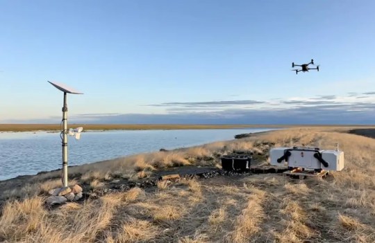
The use of unmanned aerial systems (UAS) has exploded in recent years as State and local agencies continue to find new and innovative applications for this versatile technology. The Alaska Department of Transportation and Public Facilities (DOT&PF) recently expanded its UAS capabilities for critical infrastructure inspection with UAS docks and has approved UAS for a unique use-case—avalanche monitoring and mitigation.
Docks Provide Real-Time Link
Alaska’s remote geography and frigid temperatures present several challenges for the DOT&PF. First, while UAS can help practitioners gain a bird ’ s-eye view of bridges and other critical infrastructure, the pilots must typically still be onsite, requiring them to sometimes travel long distances and face potentially dangerous conditions to deploy UAS where needed.To overcome this challenge, the DOT&PF spent nearly a year documenting and testing UAS docks. These docks are systems that allow full support for beyond visual line of sight (BVLOS) missions for UAS. BVLOS missions, where a pilot does not need to physically see the UAS during flight, represent the next big opportunity for agencies to expand UAS operations and their benefits.The UAS docks provide a secure remote landing place allowing for rapid and continuous UAS deployments, significantly reducing personnel time on site. Once these systems are set up and a flight path is programmed on site by a pilot, docks can keep the UAS and its battery warm to prevent icing, provide a platform from which to take off and land, recharge the unit, and upload its data to the web through a satellite internet connection.“Using docks replaces some of the human support needs on the ground and gives us better situational awareness through data collection,” said Ryan Marlow, UAS/Drone Program Coordinator for the Alaska DOT&PF Division of Statewide Aviation.The docks allow the DOT&PF to program flights for repeated data collection on a time schedule or on-demand, depending on the needs of the mission. While evaluating docks for emergency response along Alaska’s Dalton Highway, the agency deployed UAS morning and evening, capturing data for managers to conduct analysis from over 600 miles away. The DOT&PF could also share the collected data in real-time with other organizations and groups, which led to more effective communication and collaboration.“Everything is controlled through a web interface,” Marlow added. “Users can access from home, work, or through a mobile device. These docks can provide a real-time link to the UAS, even during a mission, to anyone who needs access to the data. This greatly reduces the personnel needs of having to have experienced pilots onsite. Now, pilots can support these missions remotely, even from other States.”Even with the benefits that UAS docks offer, the agency still needs a way to deploy them quickly to sites that are sometimes very far away. The DOT&PF is testing lightweight dock units that can be shipped on the small aircraft used to travel between locations in the State. The agency is currently preparing for a full winter trial of these docks with icing and snowfall to test durability.
Avalanche Monitoring and Mitigation
Avalanches present a dangerous and sometimes deadly challenge for the people of Alaska. In all areas of the State, even near its biggest cities, losing road access can result in critical challenges to residents, infrastructure, first responders, and the supply chain due to single entry and exit points. Deploying docks to support UAS monitoring of avalanches offers a potentially safer, reliable alternative to traditional methods.Preprogrammed UAS missions can collect snow distribution data automatically without the need for human interaction, providing the data to avalanche specialists who are sometimes hundreds of miles away. This important information can potentially be used to make data-driven decisions on hazards and where avalanche mitigation may be necessary.“Using a remotely deployed dock and UAS, organizations can now accomplish in a day what would have taken an entire team several days of travel and acquisition to do using manned aircraft,” said Marlow.When it comes to actual avalanche mitigation, when conditions are appropriate, specially trained maintenance crews use military artillery and other methods to artificially trigger avalanches at certain sites. The DOT&PF gained Federal Aviation Administration approval to develop a dropping mechanism that will attach to the UAS and allow remotely controlled pinpoint explosive drops to trigger and redirect avalanches. This will offer an alternative mitigation option that requires less manpower compared to using military artillery, with the added safety benefit of reducing exposure times to personnel.The combination of dock-based BVLOS operations and remote dropping capabilities is an advancement over all traditional methods of avalanche mitigation efforts. With these new capabilities, Alaska can monitor remote and difficult to access locations with high levels of precision to make highly informed decisions about where avalanches present the greatest risk. With the increased availability of avalanche risk data, the capability to precisely and remotely place explosives to trigger avalanches under controlled conditions represents an extreme improvement in safety for the public. This monitoring and mitigation approach with these new UAS-based technologies can serve to maintain high-risk avalanche corridors throughout the United States.“The sky is truly the limit when it comes to UAS and their possibilities,” said James Gray, Every Day Counts round five UAS team lead. “We, at FHWA, are excited to see States continue to embrace this technology and integrate it into their ongoing operations processes.”Contact James Gray, UAS program manager, FHWA Office of Infrastructure, for UAS information and technical assistance.Contact Ryan Marlow, UAS program coordinator, Alaska DOT&PF, for details on Alaska’s program.
Read the full article
0 notes
Text
Trimble and Skydio Integrate Technologies to Deliver Insights to Construction, Utilities and State Transportation Agencies
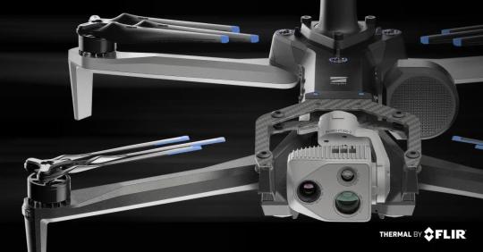

Automated Workflow in Drone Surveying, Mapping, and Inspection Turns Data to Insights San Mateo, CA Nov 2023 —Skydio, the leading U.S. drone manufacturer and world leader in autonomous flight technology, today announced a strategic collaboration with Trimble creating an integrated workflow of accurate data capture, data visualization, and data analytics addressing the needs of critical infrastructure industries in their surveying, mapping, and inspections. This collaboration, currently in the developmental stage, will enable customers to benefit from centimetre-level accuracy in survey and mapping projects through the precise data capture, visualization, and analytics enabled by Skydio autonomous drones integrated with Trimble GNSS receivers and software.Announced at Trimble’s annual user conference, Dimensions, the combination of the recently announced Skydio X10 autonomous drone with Trimble Construction Cloud will enable construction, and utility companies, as well as state transportation agencies to streamline workflows for greater precision and project efficiency. Autonomous drones, quadcopters with powerful visual and thermal camera sensors such as the X10, are relied on by industry leaders for their ability to capture real-time condition reports of critical infrastructure conditions. By capturing images and geospatial data early and often throughout construction projects, organizations can more easily ensure on-site work matches the design and reduce costly rework, which for the average project can easily be 4-6% of the overall construction cost. When bridge or utility site inspections need to scale, using the Skydio and Trimble integration delivers comprehensive data and workflow needed to identify issues early and take action to prevent failures.“This collaboration brings together two leading companies and their innovative technologies to further revolutionize how we digitize and map our physical world,” said Gagan Kanwar, Skydio’s Head of Technology Partnerships. “By deepening product integration, organizations using Trimble and Skydio will benefit from survey-grade accuracy in mapping missions and go from data-to-insights that much faster.”“Incorporating Skydio into our ecosystem augments our platform’s capabilities, offering our customers a fully integrated, end-to-end workflow from data acquisition to analytics,” said Aviad Almagor, Vice President of Technology Innovation at Trimble. “Our customers are seeking such automated workflows to handle the vast amount of data and maximize its value through improved production and quality control processes.”Key benefits of the Skydio and Trimble collaboration include:- Automated Data Integration: An automated, API-based integration enables seamless transfer of drone-captured imagery and metadata from Skydio Cloud to Trimble Industry Cloud. This integration accelerates the conversion of reality-capture data into actionable insights that enable more efficient and shorter decision-making processes. Further refinement and analysis of the output data can be carried out in professional surveying and mapping environments such as Trimble Business Center (TBC).
- Survey-Grade Accuracy with Skydio X10: Skydio’s flagship X10 drone with the RTK GPS attachment will be fully compatible with Trimble’s GNSS receivers, enabling mutual customers to achieve survey-grade accuracy in mapping missions when employing Skydio alongside Trimble’s base stations and GNSS receivers. Beyond RTK, customers will also be able to conduct PPK based corrections post-flight.To learn more about this integration between Skydio Cloud and Trimble Connect, we invite you to join us at Trimble Dimensions and attend the Skydio session on “Autonomous Data Capture” on Wednesday November 8th, 2023 at 1 PM PT.About SkydioSkydio is the leading U.S. drone manufacturer and world leader in autonomous flight. Skydio leverages breakthrough AI to create the world’s most intelligent flying machines for use by enterprise and government customers. Founded in 2014, Skydio is made up of leading experts in AI, robotics, cameras, and electric vehicles from top companies, research labs, and universities from around the world. Skydio designs, assembles, and supports its products in the U.S. from its headquarters in San Mateo, CA, to offer the highest standards of supply chain, manufacturing and data security. Skydio is trusted by leading enterprises across a wide range of industry sectors and is backed by top investors and strategic partners including Andreessen Horowitz, Levitate Capital, Next47, IVP, Playground, and NVIDIA. For more information visit Skydio.com.
Read the full article
0 notes
Text
Archer Aviation And BETA Technologies Collaborate To Accelerate The Adoption Of An Interoperable Charging System Across The Electric Aviation Industry

- Archer Aviation has purchased several units of BETA’s interoperable and multimodal fast-charging system, which employs the Combined Charging Standard (CCS) utilized by top original equipment manufacturers (OEMs) in the electric aviation industry
- In September, the General Aviation Manufacturers Association (GAMA) published a report titled “Interoperability of Electric Charging Infrastructure” that highlights the fact that shared charging infrastructure offers numerous benefits over multiple proprietary protocols developed by OEMs
- The goal of BETA and Archer’s industry-first collaboration is to spur the widespread roll-out of an interoperable electric charging network that follows the standards outlined by GAMA and supports the broad electrification of vehicles
- BETA’s charging systems are already in use at 14 locations across the eastern U.S and development work is underway to install them at another 55 locations along with East and Gulf Coasts, as well as at Archer’s flight test facilities in CaliforniaSANTA CLARA, CA. & SOUTH BURLINGTON, VT., November, 2023 – Archer Aviation Inc. (NYSE: ACHR), a leader in electric vertical takeoff and landing (eVTOL) aircraft and BETA Technologies, an electric aerospace company developing electric aircraft and charging systems, have announced an industry-first agreement to accelerate the roll out of an interoperable fast-charging system across the electric aircraft industry. Archer is utilizing two of BETA’s Charge Cube systems at Archer’s flight test facilities, as well as a number of BETA’s Mini Cube mobile charging systems, which Archer plans to rapidly deploy as needed. BETA’s charging system utilizes the Combined Charging Standard (CCS) – a multimodal, interoperable standard employed by the top OEM’s. This GAMA endorsed standard comes with peer reviewed and global certification standards and is harmonized with EUROCAE ED-308. BETA’s charging systems are already in use at 14 locations across the eastern U.S., and development work is underway to install them at another 55 locations along the East and Gulf Coasts, as well as at Archer’s facilities in California. Gaining access to BETA’s leading electric aviation charging system and network through this collaboration is another critical component of Archer’s plan to create the most efficient, and scalable, path to market for Archer’s eVTOL aircraft. Archer’s chargers bring BETA’s network to the west coast. This milestone collaboration for the industry follows the expansion of BETA’s network down the east coast – including the first electric aircraft charger on a DoD installation located at Duke Field, Eglin Air Force Base. “Fast charging is critical to ensure rapid turnaround times between flights,” commented Adam Goldstein, Archer’s founder and CEO. “A widespread, fast charging system is critical to ensuring electric air taxis reach scale in the coming years and this collaboration between two industry leaders is an exciting step towards achieving that.”“Over the past decade, transportation has shifted toward electric and now we’re seeing resonance and viability for aviation to do the same,” said Kyle Clark, BETA’s Founder and CEO. “A backbone of reliable, fast and accessible infrastructure will be critical to enabling this technology, which is why we’ve been focused on building out a charging network alongside our aircraft for some time now. When we designed our chargers, we saw an opportunity to support the entire sector by using an already peer reviewed standard, and we’re thrilled to collaborate with Archer now to validate that aim.”“The adoption of a unified charging standard will help promote electric aviation’s development at scale,” said Pete Bunce, President and CEO of GAMA. “Enabling electric aircraft and electric ground vehicles from different manufacturers to share charging infrastructure will help reduce the costs of electrifying existing infrastructure. A common standard will boost confidence in the emerging Advanced Air Mobility sector of our industry and encourage adoption of, and access to, publicly accessible charging networks.” Dr. Michael Schwekutsch, SVP Powertrain at Archer, added: “During my time as the VP of Powertrain Engineering at Tesla it was well understood that having a widely accessible, fast-charger network was key to driving the adoption of EVs and the same is true for eVTOLs and that’s why we are so excited to collaborate with BETA to build out the charging network for our electric air taxis.”About ArcherArcher is designing and developing electric vertical takeoff and landing aircraft for use in urban air mobility networks. Archer’s mission is to unlock the skies, freeing everyone to reimagine how they move and spend time. Archer’s team is based in Santa Clara, CA. To learn more, visit www.archer.com.
Read the full article
0 notes
Text
DroneTag Beacon BS Review
Boy, oh boy! What the BS is this. Here we are. After a short, unexpected delay and just some waiting, like many of you out there, I have finally gotten my hands on the Dronetag Beacon BS.
If you’re one of those waiting, the manufacturer has assured me that they are getting that backlog out as soon as possible. Demand skyrocketed and due to that supply fell short.
That’s a good problem to have. Right?
If you’re the Manufacturer it is, but as the drone pilot waiting, eh, not so much. Luckily for all of us, the FAA has placed a sort of moratorium on RID enforcement until March 16th, 2024.
As you may or may not be aware, we here at Droneblog have been reviewing, over the last summer, everyone’s favorite topic, Remote ID, and with that, Remote ID modules.
You’re welcome to go back and read those articles; it may just help you decide which one of these modules suits your needs and wallet best.
As a matter of fact, here are some links to them, just to make it easier.
For the most part, we’ve only really covered the self-contained modules. Today though, we’ll be looking at a different type of RID module.
The Dronetag Beacon BS, I know, right? I think the folks over at Dronetag were having a bit of fun when they named this one.
Despite what most of us think when we hear the term BS, you know Prairie Cakes, the Dronetag Beacon BS actually refers to Basic Solution.
As opposed to the self-contained modules that we looked at pretty thoroughly, this is one of the first that we have received that is meant to be installed into the aircraft and is not a self-contained system.
This type of module is intended for those within the RC flyer community and the homebuilders and FPV flyers.
There are a few ways this device can be configured and installed. Don’t worry we’ll cover that and more below!
As with any product, drone or otherwise, there are some drawbacks and some positives that always come along with them.
Here we have some of those pros and cons for the Dronetag Beacon BS.
✅ Pros
- The Dronetag BS is a compact and user-friendly device that can be installed on any drone as a standalone Remote ID device.
- The device is Bluetooth-powered and has a broadcast range of 3 km, fully satisfying the FAA’s Remote ID requirements.
- The Dronetag Beacon BS is one of the most affordable solutions currently for drone hobbyists, aero-modelers, and FPV pilots alike to meet the FAA’s new Remote ID standards.
- The Dronetag Beacon BS is compatible with the easy-to-use Dronetag App for managing your drones and RID devices, as well as checking flight zones, and scanning for other active drones in your area.
❌ Cons
- Dronetag Beacon BS is not suitable for people looking for a plug & play solution. It does require at least some basic electronic expertise to get it installed and up and running.
- The device is not compatible with DJI or any other branded off-the-shelf drones with sealed-off hardware. For such drones, the better option would be the much more costly self-contained module, the Dronetag Beacon, currently priced at $199.
- Although the device is not privacy-invasive, it does require some personal information to be shared with the company. Although, in our current world, this isn’t really a con per se, just kind of par for the course. But there are some who would see this as a con, which is why I have included it as such.
» MORE: What is Remote ID (RID) and Why is it Needed? (Explained)
Quick verdict
To sum it up, Dronetag is a very good company to work with. I have yet to have any issues with them or any of their products.
Even when I did have some questions, the team over at Dronetag was quick to respond and provided all the assistance they could.
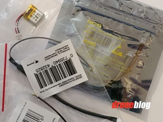
As to the Beacon BS, it was fairly straightforward to install. No! I didn’t install it myself. My soldering skills are a bit, let’s say, unrefined.
Oh, heck, that’s putting it nicely. If you just want a big blob of solder, I’m your guy.
No, we had our tech guy Chris, or, better known as SkyFoxFPVulpine help us in that regard. He does all my repairs, and yes, he’s really good at it.
He immediately knew just what everything was out of the package and, in about 20 minutes was able to complete the task, and we were good to go.
Upon the first use, it did take a moment or two to connect, and it’s important that you make sure the firmware is up to date.
After that, though, we were able to find ourselves on the app and track the module.
For the $89 and the fact that it is now mandatory, Dronetag has presented us with a fine product that is easy to install and use.
So, although there may be a few, a couple, er, one other module that is less expensive, you can buy with confidence that Dronetag is doing it right. Even if it may take a little bit to arrive.
» MORE: Best Remote ID Modules (So You Can Be in Compliance)
Who is it for?
That is a very good question, who is it for! Well, the homebuilders, the RC flyers, those fixed-winged fellas and gals out there.
In other words, anyone who is not able to affix one of the self-contained modules, such as the ones we’ve already reviewed, either due to the size or weight of those self-contained modules.
You can also look at it this way. Flyers that fall into this group, hey, you’re saving a bit, as most of the self-contained modules are running a bit higher than this one. T
he pricing of those starts at $130 and goes up from there.
» MORE: How to Get Remote ID for Drones
Product Overview
The Dronetag Beacon BS is a 1-gram device which, once installed into your aircraft of choice, will bring your craft into Remote ID compliance, with the required Bluetooth Direct / Broadcast RID.
It has two external antennas, one for Bluetooth and one for GNSS positioning.
It has an option for a separate power source or can be wired directly into the aircraft itself and its onboard power system.
The Dronetag Beacon BS is so flexible that you can use it on any drone you use.
Built into the Dronetag Beacon BS is a small amount of flash memory, which allows it to store a few hours of flight log data, which, if need be, can be exported for later use.
It also has a built-in supercapacitor to maintain its GPS fix for up to 7 mins.
This is actually a nice feature that is built-in as most FPV aircraft have short battery runs, and you won’t lose that GPS lock while swapping batteries and then having to wait for it to lock again.
With a Mobile App available, you can quickly access the settings or update the firmware.
It also works with Betaflight, with plans in the near future to work as a telemetry module for systems using Futaba, Spektrum radio controllers, through the JST connector.
» MORE: Remote ID – The Dark Side (And History of FAA Regulations)
Specifications
- Remote ID types: Direct (EU) / Broadcast (US)
- Short-range radio: Bluetooth 2.4GHz
- Average current consumption: 15 mA
- Maximum current consumption: 50 mA
- Mounting: Adhesive or velcro
- Operating temperature: -40°C to +85°C (-40°F to 185°F)
- Dimensions: 17 x 14 x 5 mm (0.66 x 0.55 x 0.19 in)
- Weight: 1 gram (0.035 oz) excl. antennas and battery
- Supported baud rates: Standard ones, configurable in the Dronetag app
- Input voltage: 3.3 – 17V
- Input voltage regulator: Low-noise buck converter
- Remote ID Standards: ASD-STAN EN 4709-002 & ASTM F3411-22
- Certifications: Uses FCC/CE-approved radio module.
- Remote ID technology: Bluetooth 4.0 Legacy + 5.0 Long Range
» MORE: List of DJI Drones with Remote ID (2023)
Personal Opinion
In my personal opinion, this is a fantastic solution for the FAA-required Remote ID. It is cost-effective and functional.
One of the best aspects of it is if ever questioned about whether you are compliant or not, you can say with confidence that you do indeed have your BS attached.
After all, what’s life without a little bit of humor?
The fact is, Dronetag has worked very hard and has dedicated itself to being the leader of the Remote ID module manufacturers, and it has set a prime example of how it should be done.
As a result of this, it has created a product line of some of the best modules we’ve seen come to market and has diligently worked to assist pilots even after the purchase is made by developing an app that provides an ease-of-use factor.
We’re just not seeing that with all of the rest of the modules coming out.
The Dronetag Beacon BS is, like all of their products, made of quality materials and not only meets the FAA requirement for Remote ID but also exceeds that requirement.
» MORE: Does DJI Avata Have a Remote ID? (Explained for Beginners)
Features Breakdown
Let’s look into the features of the Beacon BS a little bit.
As I mentioned above, one of the very best features found on the Dronetag Beacon BS is probably the built-in supercapacitor, as this allows for the pilot to conduct a battery swap without having to then wait for the module to reacquire the GPS connection.
Brilliant, since, typically with the limited flight time of an FPV quad, you wouldn’t want to wait for that reacquisition.
Another of the features that stand out with the Beacon BS is the optional power supply.
You can opt to either use the onboard VIN or an external single-cell LiPo battery, as shown in one of the photos above.
Although in most cases, wiring into the onboard power supply is the optimal setup, having that option is nice and allows you, the pilot, to disable the module if flying in an environment where Remote ID is not required, such as indoors.
Now, if you’ve ever flown FPV, you are aware of what Betaflight is. Our friends over at Dronetag thought about that too!
With the addition of an M10 module from U-Blox, this little add-on allows for GNSS integration to a Betaflight controller, with the planned addition of adding telemetry for Futaba and Spektrum.
There is just a whole lot going on on that tiny little circuit board.
» MORE: Registering Your Remote ID Module With the FAA
Conclusion
Ultimately, what we are left with is it a good buy for you. Well, yes! Hey, I know there are a lot of pilots out there who find the whole Remote ID thing to be BS.
Well, here’s your BS, your Beacon BS, that is.
It does not matter what side of the aisle you are on with Remote ID. It’s here, and as a drone pilot, it’s entirely up to you to be in compliance with the regulations; that doesn’t translate to you having to like said regulations.
If you’re a conscientious pilot, you want to be doing everything you can to be within the regulations as they have been put forth.
The Dronetag Beacon BS offers us that option and at a price point that won’t necessarily break the bank.
For the price of the Dronetag Beacon BS, you’re certainly getting your money’s worth from the purchase price, from a company that has very good standing within our industry.
They have provided quality products from the beginning with excellent customer service added in.
Read the full article
0 notes
Text
DJI Transmission System (Everything You Need to Know)

An essential feature behind a DJI drone that is often overlooked is the drone transmission system.
I have personally flown multiple DJI drones from different generations, and I can say – good heavens, what a difference!
DJI drones usually have the OcuSync transmission system, which is unique and proprietary to DJI. The transmission module is installed on all DJI drones and cannot be upgraded or changed, but it comes in different versions. And the flight range, penetration, controller compatibility, and a few more factors depend on it.
Here, I’ll share with you everything you need to know about the DJI transmission system, why it matters, the difference between them, and how we can identify one.
Behind DJI OcuSync: Factors & Analysis
A transmission system in a drone is one of the most critical parts without which a drone cannot fly at all. It simply cannot make a connection between a drone remote controller and the drone itself.
In consumer DJI drones, we have the OcuSync transmission system, which has two roles:
- It captures live video and sends it back to the pilot. The pilot receives a live feed, which can be seen on the phone screen connected to the remote controller or the DJI RC with a screen incorporated. The OSD is also transmitted by the same module with all the information you need to see during a flight (battery left, signal strength, direction, etc.)
- The OcuSync on the drone also receives radio input. The pilot information is sent from the remote controller and received by the same drone module.
In FPV, we have two different modules: the video module (VTX) and a separate radio RX module that receives input on a different protocol. But not with DJI.
Therefore, without a transmission system, you cannot control the drone or see a live feed.
» MORE: Long Range Drones: Ultimate Guide
What is the difference between various DJI transmission systems?
As drone technology evolves at an incredible rate, so does the DJI OcuSync.
There are quite a few differences between the different versions, so let me help you understand what can be affected when you’re about to choose a drone based on this feature.
- Flight Range: The flight range is the first to be affected. Newer OcuSync versions always come with a significant improvement in flight range and signal strength between the radio and the drone. DJI has always done an excellent job in creating long-range drones, primarily because of their transmission systems.
- Flight Penetration: Flight penetration is yet another vital factor that we’ll often observe to improve with newer OcuSync systems. From flying a drone behind obstacles and trees to areas with significant interference, the signal penetration of a drone is directly impacted by the OcuSync transmission version.
- Live feed resolution and framerate: What we see on our phone or RC screen, the details we observe, come with a specific resolution and framerate. That’s yet another factor impacted by the OcuSync version. With the newer versions, the drone can transmit more data in real-time, hence taking advantage of better resolution and framerate.
- Latency: In drone terms, latency is the response time between the drone remote controller and the drone itself when we relate to radio transmission or between the drone video system and the image displayed related to the video transmission. Older OcuSync versions and cheaper radios will have slower response times.
- Compatibility: All these DJI drones with an OcuSync transmission system have to be compatible with a radio that supports the same protocol. That’s why never buy an RC unless you’re confident it’s compatible with your DJI drone.
» MORE: When Should You Upgrade Your Drone? (Read This First)
OcuSync versions
Let’s not jump ahead and start with the ancient technology found in the early version of drones that are not used anymore today.
You may not be interested in that.
What you need to know is that currently, there are DJI drones in production as of today that use OcuSync versions 2.0, 3.0, 3+, and the latest, 4.0. We’ve flown drones with nearly all of them and have tested them thoroughly at Droneblog, so this is the voice of experience.
What’s the difference between these versions? How do they handle all these features?
I remember when I had my first Mavic Air, it struggled to go beyond 500 meters (0.3 miles) in the distance before breaking up the signal badly.
It was indeed that bad. As far as I know, it used some kind of dual-band Wi-Fi transmission technology.
But it was an amazing first drone. I get goosebumps when I remember it. Let me share with you one image I was able to capture at a maximum distance before I completely lost connection in line of sight (so I remember)
Then, I upgraded to a Mavic 2 – my first “long-range” drone. What a difference between these two drones – what a DIFFERENCE!
Imagine this being only a few years back. Now, if we think about it, the transmission system in these drones was of the first and second generation, and as compared to today’s O4, we literally compare futuristic with ancient technology.
» MORE: Smart Features in Drones (Explained for Beginners)
OcuSync 2.0

From the first time it was released, the DJI OcuSync 2.0 with Mavic 2 in 2018, DJI drones started to be capable of flying long-range.
Five years later, the OcuSync 2.0 is still in production with the new DJI Mini 2 SE and Mini 3 and can be found on multiple drones, including the DJI Mini 2, Mavic Air 2, Mavic 2 Pro & Zoom, Phantom 4 Pro V2 and DJI Matrice 300 RTK.
It was the first significant improvement to be able to see, on some drones, a live feed resolution of 1080p, enjoying the skies and observing nature on a large tablet with… again, goosebumps…
With the OcuSync 2.0, we were also able to fly our drones on dual-band 2.4 and 5.8ghz, and, depending on the drone, we could fly up to 3.7 miles in Europe and 6.2 miles in the USA.
The intermittent switching between these two bands was an important feature to observe with OcuSync 2.0 and changed the perspective on how a DJI drone flies in different environments.
OcuSync 3.0
As drone technology has evolved, we are now seeing the most used transmission system in all DJI drones: the DJI O3, or OcuSync 3.0
Surely, you’ve heard about the DJI Mini 3 Pro or maybe about the DJI Air 2S. Excellent drones, capable of flying long-range without issues.
That’s only because of the new and improved OcuSync 3.0 system over the older 2.0.
While the 2.0 version was very cost-effective, and we can often see it in budget entry-level drones, with the greater O3 power, there comes a higher price for these drones.
In terms of performance, the OcuSync 3.0 significantly improved over the 2.0.
Depending on the drone, we can see drones such as DJI Mini 3 Pro capable of flying up to 5 miles in Europe or 7.5 miles in the USA (in geo-restricted environments) or see a boost of flight distance up to 15.5 miles or 25km with DJI Mini 3 Pro and Intelligent Battery Plus.
What a difference!
The OcuSync 3.0 also proved very capable of flying farther in heavy-interference areas, such as urban or downtown WiFi-choked environments.
Moreover, we are now seeing the DJI RC-N1 and DJI RC (with screen), the two most used DJI controllers ever to boast full compatibility with all OcuSync 3.0 drones.
But in terms of compatibility, the DJI RC-N1 can also work with a few older O2 DJI drones, whereas both RC-N1 and DJI RC are compatible with a few OcuSync 3+ drones (from the Mavic 3 series).
» MORE: DJI Mini 3 Pro: One-Year Review (Video)
OcuSync 3+
Moving on, the OcuSync 3+ is a minor improvement of the original O3 System that is found on most DJI drones nowadays.
Currently, we can see the OcuSync 3+ transmission system only on the most advanced consumer drones released by DJI, the Mavic 3 series.
And that’s it.
Paying thousands of dollars for such drones, we had to see some advantage in terms of range and penetration, so we took this addition.
Moreover, these Mavic 3 drones are compatible with the professional-level radio controller, the DJI RC Pro, which takes full advantage of this new transmission system.
The same DJI RC Pro is also cross-compatible with the DJI Air 2S, which comes with the standard O3 version.
Moreover, the O3+ Mavic 3 drones are well-compatible with DJI RC and RC-N1 controllers that boast the O3 basic version.
See DJI? Cross-compatibility is possible! Why don’t we see it more often with newer drones?
Now, moving into the technical data of the DJI O3+, with the Mavic 3 series, we can realistically see a transmission range of 5 miles in Europe or 9.3 miles in the USA.
If we’re talking about unrestricted environments, the Mavic 3 drones can fly up to 18.6 miles or 30 kilometers.
What an improvement!
But the great advantage of the O3+ is that being hosted in a professional-level, commercial drone, we needed a more robust transmission to penetrate interference, to be able to take real-estate photographs, inspect a building, or do some mapping without having to deal with spotty connections.
The O3+ transmission system, the same as O3 and O2, operates on dual-band 2.4 and 5.8 GHz but at much greater power.
We can also see the live view image on 1080p at 60fps with the more expensive DJI RC Pro.
» MORE: DJI Mavic 3 Pro Review (I have NEVER flown a drone that I enjoyed so much)
OcuSync 4.0
With 2023, we have a new era of high-end drone technology that surpasses anything ever manufactured, at a fraction of the price.
If you’re just about to get into the drone hobby, I strongly recommend, without any doubt, going either with the DJI Air 3 or DJI Mini 4 Pro.
Both these drones come with the latest transmission technology, the OcuSync 4.0 (and much more).
After several years of enjoying drones at the top of the line in terms of transmission power with the OcuSync 3.0, now those drones look like toys in comparison with O4.
No joke here.
The OcuSync 4.0 is currently the most powerful transmission module found in basically any consumer drone.
We’re still limited in Europe with a realistic range of 6.2 miles or 10km, but in the United States… well… I’m wondering how, but both the Air 3 and DJI Mini 4 Pro are restricted to 12.4 miles or 20km in transmission range.
That is way beyond the visual line of sight if we’re following the drone laws.
But in reality, with no restrictions, the O4 transmission system is capable of flying a competent drone for up to 20 miles or 32 km.
See where we got? How can I compare such drones with the 0.3-mile transmission on my old Mavic Air? It’s good that I’ve sold it, though.
And that’s how drone technology has evolved in the past few years. What should we expect in the next 5 or 10 years?
On the technical side, the DJI O4 uses the same 2.4 and 5.8 GHz dual-band transmission, has a low latency of up to 120ms, and this new OcuSync system is compatible ONLY with two new remote controllers:
The DJI RC-N2 and DJI RC 2.
We’re glad to see it this way only to obtain the best transmission system.
Read the full article
0 notes
Text
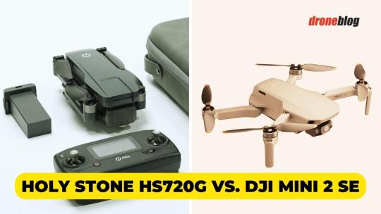
Holy Stone HS720G vs. DJI Mini 2 SE (Here’s My Favorite)
If you’re here, it’s because you’re contemplating purchasing the Holy Stone HS720G or DJI Mini 2 SE, perhaps as a first drone, a second model, or even a gift for a child or family member.
I’ve had the pleasure of flying both these drones, and with this experience under my belt, I can say with confidence which one is the better drone.
This guide will delve into the common ground shared between the Holy Stone HS720G and the DJI Mini 2 SE and how they differ. I’ll also share my experience with these drones to explain why the Mini 2 SE is far and away the preferable drone of the two.
Are you ready to learn more? Join me in this comparison of these two great drones so you don’t waste a cent on a drone you don’t need.
Overview
Holy Stone HS720G
Declared Holy Stone’s flagship drone, the HS720G was released in 2022. As a flagship, it has the professional appeal you’d see in an Autel or Yuneec drone, maybe even a lesser DJI model.
Its price is flagship to match.
In other words, this isn’t your grandma’s Holy Stone drone.
It’s built more rugged and loaded with more features to make it a contender against the DJI Mini 2 SE, yet it doesn’t venture too far outside the realm of what makes Holy Stone a favorite.
It’s still beginner-friendly and portable but with surprisingly cool features like:
- Brushless motors for exceptional durability and great speed. You can zip around like a daredevil and take awesome drone footage (within legal parameters, of course).
- A two-axis stabilizing gimbal, so you don’t have to stress about your social media footage coming out blurry like you’re trying to capture the Loch Ness Monster.
- A 4K camera, which may not be that much to write home about from other drone brands, but is quite the high-quality inclusion for a Holy Stone.
- A transmission distance of over 3,000 feet, so you never have to skip a beat when taking drone videos. You can live-stream them or upload them to your social media feed pronto.
» MORE: Holy Stone App – All You Need to Know
DJI Mini 2 SE
Drones in DJI’s Mini line come atcha fast. The Mini SE was released in July 2021, followed quickly by the Mini 3 and Mini 3 Pro in 2022 and the Mini 4 Pro in 2023.
The Mini 2 SE is somewhere in between, coming out in 2023.
So why consider the Mini 2 SE over the other DJI Mini drone options? For so many reasons!
- This drone is beginner-friendly as all get out. Young kids can easily navigate this lightweight and portable drone, while teens and adults should find it easy to master as their first drone.
- It’s compatible with 360-degree Propeller Guards for a safe flying experience. As a beginner, you’re a lot likelier to ding your drone into everything until you learn the ropes. The prop guards prevent drone destruction after your first accident and spare your fingers from painful lacerations!
- You can make incredible-looking footage using the Creator Templates in the DJI Fly app. Social media trendsetters, influencers, and content creators can up their game with a drone like the Mini 2 SE.
- It shoots videos in 2.7K HD quality and 12 MP image quality with its three-axis motorized gimbal. This isn’t the best quality on the block, but for beginners, it will seem immaculately high-quality.
» MORE: DJI Mini 2 SE App (Read This Before Downloading)
Quick Verdict
In our effort to present the best drones to you on Droneblog, all recommendations are made after extensive flight performances and testing.
You can count on this verdict as you make a purchasing decision.
In the battle of the Holy Stone HS720G and the DJI Mini 2 SE, the Mini 2 SE comes out on top. It weighs less, offers more intuitive and smart flight features, has a slightly longer flight time, and enables beginners to capture cinematic footage with ease, even if the quality isn’t as good.
And yes, I know that camera quality is the end-all, be-all for some drone pilots.
While I can understand that, the slightly lower video quality of the Mini 2 SE, combined with its top-of-the-line three-axis gimbal, provides more reliable footage than the Holy Stone HS720G’s two-axis gimbal and 4K camera.
This is DJI we’re talking about here. They’re a leader in the drone world for a reason: high-quality, enduring parts.
That said, the HS720G is a surprisingly worthy contender. Most battles against Holy Stone and DJI are a no-brainer, with DJI the winner every time.
This one gave me pause in a lot of areas, which proves how far Holy Stone has progressed with its drones.
It could only be a matter of time before they’re a drone leader of the caliber of Autel or DJI!
» MORE: DJI Mini 2 SE Wind Resistance (Explained)
What are the main differences?
Holding these two drones up side by side, they couldn’t be more different. That’s not a bad thing by any stretch of the imagination, though. After all, variety is the spice of life.
Instead, it simply means that your choice will vary depending on what you’re looking for in a drone.
Comparisons will help you feel good about your decision.
Even purchasing a low-cost drone under $500, such as both of these, warrants taking the time to weigh your options, which is exactly what I’ll help you do.
Let’s start with the Holy Stone HS720G, pointing out some factors that separate it from its steep competition.
- The 4K camera is undoubtedly one of the features that sets the HS720G apart, not only from the Mini 2 SE but other Holy Stone drones. Most Holy Stone models have a 2K camera at best, so the HS720G’s camera is twice as good, promising clarity and detail when videoing footage. You might not want to rely on it for many commercial projects (perhaps if you’re just starting your drone career), but it’s more than capable for everyday activities where you want to create lasting video memories.
- The two-axis gimbal is another feature you don’t always see in Holy Stone drones or other entry-level drones like it. Eliminating the gimbal keeps production costs manageable, so you can buy a drone for under $200. Although the HS702G is more expensive than your average Holy Stone, it has more stabilization. Holy Stone even went the extra mile and added Electronic Image Stabilization or EIS.
- Its GPS-enabled modes, although not as many as a DJI drone, are considered a standout in a Holy Stone drone. GPS is another expensive feature to implement, but it allows the HS720G to offer follow-me, Point of Interest, and Tap Fly modes. Beginners can feel like drone experts with fun automated modes, witnessing the potential of their drone as they learn it. You can also start uploading high-quality footage to your YouTube channel immediately, even if you bought the drone yesterday.
I told you, the HS720G is quite the contender! Okay, so that’s the HS720G.
Now, it’s time to switch gears and look at the DJI Mini 2 SE.
- The size and weight of the Mini 2 SE are remarkable. This drone weighs as little as a smartphone, making it travel-ready. You can bring it in a checked luggage or carry-on when flying. For everyday traveling, it fits into a day bag, a duffel bag, a purse, a briefcase, you name it! It folds, so it won’t take up valuable space you might not have.
- You can forget about two-axis gimbals and EIS when the Mini 2 SE boasts a three-axis gimbal. Now, granted, these gimbals are standard in drones, but this feature still outpaces what the HS270G brings to the table.
- It’s ready for cinematics despite the fact that it might not have the most high-end camera in the Mini series. You can use the DJI Fly app to create the kind of breathtaking footage that goes viral, and it only takes you a couple of clicks to do it. You’ll rack up the likes and comments faster than you can say DJI Fly!
» MORE: DJI Fly App (Everything You Need to Know)
Holy Stone HS720G
The HS702G is part of Holy Stone’s advanced GPS drone collection with other top sellers like the HS702R and HS720E.
It’s surprisingly rugged, with a price that reflects its careful design considerations and feature implementation.
Does that mean it’s more expensive than your average Holy Stone drone? You betcha! It costs about twice as much.
However, I think it’s worth every penny, as the HS720G is Holy Stone’s answer to the increasingly more competitive consumer drone market and leading models produced by DJI and Autel.
Besides, the additional expense gets you a lot of fantastic features you usually can’t find in a Holy Stone drone, or at least not as comprehensively as they’re packaged in the HS720G.
It has anti-shake features, primarily in the form of a gimbal, and its 4K camera is another feature that will make you do a double-take to confirm that, yes, this is really a Holy Stone drone you’re flying.
If you care about cool points, which I know I do, this drone looks epic flying in the sky. You won’t shy away if you visit a park or drone airfield and share the skies with other pilots. You’ll fly this baby with pride, and rightfully so!
Are you into smart features? The HS720G could have more, admittedly, and if you put it to the test against the Mini 2 SE, it’s an easy no-contest. That said, you must consider who this drone is catered toward: beginners.
Yes, that’s right, the HS720G is a beginner drone through and through. It doesn’t look like it, which I personally appreciate a lot, but it is indeed designed for first-timers.
Perhaps you’re in those shoes. A new pilot doesn’t need a suite of smart features. It’s too overwhelming. A couple suffice until you get bored of the drone or outgrow it and move on to a more complete model.
» MORE: Do Holy Stone Drones Have Geofencing (And How to Unlock)?
You can create your own waypoints and track people with the drone, and that’s enough to explore what drones can do, especially for your first.
Influencers and social media superstars looking to get into drone videography will especially appreciate how easy it is to use the HS720G’s features, especially the GPS ones.
It’s simple and intuitive to get this bad boy into the sky and do what it’s best at: take videos. That also makes this drone an excellent choice for a child’s first!
Holy Stone HS720G (2 Axis Gimbal)
$427.99
$299.99
GPS Drone with 4K EIS Camera for Adults Beginner, HS720G Foldable FPV RC Quadcopter with Brushless Motor, 5G WiFi Transmission, Optical Flow, Follow Me, Smart Return Home.
Buy from Amazon
We earn a commission if you make a purchase, at no additional cost to you.
11/07/2023 06:06 pm GMT
DJI Mini 2 SE
The Mini 2 SE continues the long legacy of the Mini drones, one of DJI’s best sellers.
This drone’s ultra-lightweight profile and dainty size make it effortless to carry around. You can stash it in your back pocket (if your pocket is large enough) and forget you even have it with you. (Don’t sit on it!)
It’s so easy to pick up and fly that it’s one of the most inclusive drones in the DJI collection. Kids to adults can experiment with this drone’s easy-to-use control scheme and begin shooting the kind of cinematic footage that grabs attention.
If you were hoping to expand your YouTube repertoire or discover if you have what it takes to work commercially in drones, this is a good pick to have by your side.
It has a three-axis gimbal, outshining the Holy Stone HS720G, and a basic 2.7K camera that shoots in 12 MP image quality. I won’t pretend that’s the best on the market, but once again, imagine the intended consumer.
Beginners aren’t huge sticklers for image and video quality. But no one wants blurry footage, as then it’s a waste to have taken it in the first place when you can’t do anything with it.
No amount of editing can save it.
» MORE: Is the DJI Mini 2 SE Worth It?
Speaking of editing, I love how intuitive DJI made it with the Mini 2 SE.
Read the full article
0 notes
Text
Airobotics Will Add More Optimus Drone Systems to Dubai for Public Safety Response
The Optimus Drone and Airbase in Urban Environment (Credit: Airobotics)
Israeli-based drone manufacturer Airobotics, (a subsidiary of Ondas Holdings) recently announced a $2.6 million order for additional Optimus drone systems from a local government entity in Dubai, UAE for public safety and emergency response operations.
by DRONELIFE Staff Writer Ian J. McNabb
The Optimus system, which is based on a network of drones centrally operated from an urban command center and is designed to replace the role of a helicopter for law enforcement and first responders, has been active in the UAE for some time, including as a joint venture with UAE-based SkyGo in Abu Dhabi, but this larger acquisition deal highlights the potential of fleet-based first responder UAV solutions in urban areas. The system has already completed thousands of successful missions without human intervention in the challenging environmental conditions of the Middle East.
The Optimus drone recently achieved an Airworthiness Type Certification from the Federal Aviation Administration (FAA) and is the first small UAS (sUAS) developed for aerial security and data capture to receive a Type Certificate. While the technology is first being applied to the Public Safety and Security industry, future applications of the command-center based decentralized approach, which is built on individual, fully autonomous launch stations capable of routine preflight operations (like battery or sensor swaps) distributed around an urban area could include parcel delivery or other “smart city” operations.
“We are proud to receive an additional order for Optimus Systems from our customer in Dubai,” said Meir Kliner, Airobotics’ CEO and President of the Ondas Autonomous Systems business unit. “We are working to grow our Optimus deployments in Dubai and fulfill the vision of a fully automated urban drone infrastructure for Public Safety and Emergency Response. Together with Ondas’ American Robotics, we are bringing these capabilities to the United States where we can leverage the Optimus drone FAA Type Certificate required to enable similar operations.”
More information on Airobotics and Ondas is available here.
Ian McNabb is a staff writer based in Boston, MA. His interests include geopolitics, emerging technologies, environmental sustainability, and Boston College sports.
Miriam McNabb is the Editor-in-Chief of DRONELIFE and CEO of JobForDrones, a professional drone services marketplace, and a fascinated observer of the emerging drone industry and the regulatory environment for drones. Miriam has penned over 3,000 articles focused on the commercial drone space and is an international speaker and recognized figure in the industry. Miriam has a degree from the University of Chicago and over 20 years of experience in high tech sales and marketing for new technologies.
For drone industry consulting or writing, Email Miriam.
TWITTER:@spaldingbarker
Subscribe to DroneLife here.
Read the full article
0 notes
Text
Precision mapping with the DJI Mini 3 Pro and Litchi
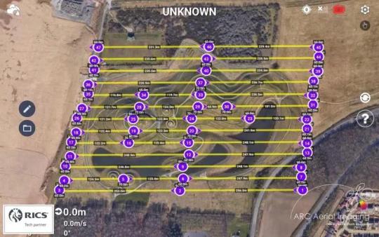
Acquiring ultra-high-resolution aerial imaging by using the capable DJI Mini 3 Pro and the publicly-released beta ‘Litchi Pilot’ app by proving again that this sub-250g UAV’s outputs can be applied towards topographic mapping, surveying, and photogrammetry. Several ‘survey accurate’ geospatial outputs were produced at an RMSE of 18.6mm which is better than the ‘20mm to 50mm’ realistic range of drone/photogrammetry-derived accuracies as detailed in the ‘RICS Professional Guidance Note – Measured Surveys of Land, Buildings and Utilities’.With a terrain-following collection flight at 60m high over the huge ‘Northumberlandia’ (the “Lady of the North”) land art sculpture, it enabled the DJI Mini 3 Pro at its ’48MP’ JPEG resolution setting applied to collate over 450 high-overlapped nadirs at a consistent spatial resolution of 1cm/px GSD. After a successful collection, onward imagery rectification with several GCPs from a survey GNSS that were recorded at an X,Y,Z accuracy of 10mm and processing in Pix4DMapper photogrammetry software, it resulted in the generation of several highly accurate geospatial datasets.What to know more and how it can be done?Professionally delivered by an instructor who has over 30 years of accredited subject matter expertise (a 22 years-served Royal Air Force Imagery Analyst, a CSI Analyst Contractor, and, for the past 9 years, a highly-experienced commercial practitioner in such), attendees on ARC Aerial Imaging’s ‘Drone Aerial Imaging Masterclass Course for Mapping, Surveying and Photogrammetry’ will learn how to accurately plan and collate high-quality UAV-borne aerial imaging whilst understanding the important fundamentals and principles in such along with collating other project-supporting geodata including precise point positioning information to produce and provide accurate and survey-compliant geospatial datasets.Furthermore and as it is a RICS Tech Partner Programme member, course attendees can be assured that this specialist training is provided in accordance to RICS high standards.Visit https://www.arcaerialimaging.com/training to know much more, its comprehensive syllabus, what drone types are currently compatible with the course, and published training dates at both its North Yorkshire and Cambridgeshire-held training venues.ARC Aerial Imaging Limited
UK CAA UAS Operational Authorisation No 685
Read the full article
0 notes
Text
DroneShield Teams with ADF Drone Racing Association
- DroneShield teams with Australian Defence Force (ADF) Drone Racing Association and becomes its sponsor
- Enables for deeper collaboration between ADF drone pilots and DroneShield for C-UAS system design, operational learning and field tactics
- Systematically testing DroneShield equipment against the drones deployed by the Association, enabling two-way development of both DroneShield’s C-UAS systems, and the Association’s drone arsenal, influencing further development
- Collaboration around system design, operational learning and field tactics, including drone-swarming attack patterns
- Deepening of relationships between Australian foremost minds in drones in military applications, and the leading sovereign C-UAS capability developmentWing Commander Keirin Joyce, ADF Drone Racing Association president, commented “We are excited to enter into teaming with DroneShield, including testing our drone strategies at DroneShield’s test site in Blue Mountains and exchange knowledge, and being a part of sovereign C-UAS capability development.”
Oleg Vornik, DroneShield’s CEO, added “The ADF Drone Racing Association contains some of the best drone pilots in the country in the military context, flying small, ultra-fast drones at over 150km/hr, in unique and challenging settings. There is a large amount of operational learnings between our teams, and we look forward to the collaboration. This is a significant red-teaming opportunity for DroneShield to continue to stay at the edge of C-UAS capabilities globally.”
Read the full article
0 notes
Text
RDO Equipment Co. Joins GeoCue Alliance Partner Program, Expanding Precision Solutions Portfolio

Huntsville, AL – GeoCue, a leading provider of advanced drone surveying equipment and software
solutions, is pleased to announce the addition of RDO Equipment Co. as a GeoCue Alliance Partner. RDO
Equipment Co., with 55 years of industry experience, is a renowned provider of precision construction
solutions serving a broad range of industries across the Western United States.As part of this new collaboration, RDO Equipment Co. brings GeoCue’s TrueView 3D Imaging Systems
and LP360 software into its extensive catalog of equipment, surveying supplies, and software solutions.This strategic partnership aims to empower RDO Equipment Co.’s customers with efficient and accurate
surveying tools that seamlessly integrate into their workflow, enhancing their overall productivity.
Bill Edmonson, UAV Product Manager at RDO Equipment Co., shared insights into their decision to join
the GeoCue Alliance Partner Program.He stated, “RDO Equipment Company offers a variety of precision construction-related solutions for a broad spectrum of industries, and we guide our customers toward more efficient and accurate methods of doing their business through the integration of sophisticated technologies. GEOCUE’s TrueView LiDAR payloads and LP360 software are a complete solution end-to-end because they have removed the roadblocks between scan, process, and analysis of UAV LiDAR surveys. I looked at several other options, and none of them have the complete process from scan to actionable data as refined and straightforward as GEOCUE’s. This is important to RDO as we aim to bring the most complete solutions to our customers.”The addition of GeoCue solutions to RDO Equipment Co.’s portfolio is expected to offer significant
efficiencies for their customers. Aaron Beach, the Western US Sales Representative for GeoCue further
emphasized, “We’re so thrilled to announce our partnership with RDO, who is a national leader in
advanced construction technologies. We’ve already begun pioneering innovative new ways to deploy
Geocue’s UAS LiDAR solutions to the heavy construction industry, that not only enhance jobsite safety,
but also revolutionizes jobsite efficiency.”LP360, an all-in-one LiDAR data software solution from GeoCue, holds great promise for RDO Equipment
Co.’s clients. It eliminates the need to hop between various processing and analysis tools, providing a
streamlined and comprehensive solution for managing LiDAR data. Bill Edmonson sees tremendous
opportunities for his clients, stating, “I think LP360 will allow our customers to leverage the TrueView
payload for a variety of scan projects.”Expressing his enthusiasm about the partnership, Bill Edmonson said, “We have a high level of
confidence that we are going to market with the best overall solution in this market for quality, price,
flexibility, and support.”About RDO Equipment Co.Founded in 1968, RDO Equipment Co. sells and supports agriculture, construction, environmental,
positioning, surveying, and irrigation equipment from manufacturers including John Deere, Vermeer,
and Topcon. With more than 75 locations across the United States, including partnerships in Russia,
Ukraine, and Australia, RDO Equipment Co. is a total solutions provider.To learn more about RDO Equipment Co. visit https://www.rdoequipment.comAbout GeoCue and MicrodronesGeoCue and Microdrones have joined together to bring geospatial experts the very best in drone surveying equipment, geospatial software, workflow, training, and support for high-accuracy LiDAR and drone mapping to help civil engineering and surveying professionals achieve successful data collection, processing, and management.With TrueView drone LiDAR/Imaging sensors, LP360 point cloud data processing software, and fully integrated systems from Microdrones, we are the leader in LiDAR mapping processing in North America able to meet customers where they are in terms of technology adoption, budget, and resources.
To learn more about GeoCue, visit www.geocue.com
To learn more about Microdrones, visit www.microdrones.com
Read the full article
0 notes
Text
Altitude Angel Launches Airspace Security Division: Prism Detect

Altitude Angel, a global UTM (Unified Traffic Management) technology provider, has announced that it has launched a new division, Prism Detect, which will focus on making its ARROW technology available to customers who require advanced unified situational awareness capabilities for the detection of crewed and uncrewed aircraft.
Altitude Angel’s ARROW technology is a critical component in enabling the world’s longest drone superhighway and is an innovative array of ground-based, networked sensors ‘scanning’ the low altitude sky. The system connects to Altitude Angel’s global UTM platform, GuardianUTM, which processes the real-time data and then ‘fuses’ it to create a single-source-point-of-truth – an ultra-high-resolution, real-time, moving map of the low-altitude sky, which includes both drones and crewed aviation.
In its totality, Prism Detect provides managers of sensitive real-estate or critical infrastructure with a comprehensive and real-time view of all airspace users within a significant radius of the towers, which can be temporary, mobile, or fixed installations.
Unlike other surveillance/detection solutions, which usually take a ‘one size fits all’ approach, the Prism Detect offering can be adapted depending on the terrain on which it is deployed with the sensor array scaled or reduced to suit the operator’s needs.
Furthermore, because Prism Detect is connected to Altitude Angel’s GuardianUTM platform, operators will be able to differentiate between expected (authorised) and unexpected (unauthorised or ‘surprise’) aerial visitors, allowing those deploying the platform to be able to make informed decisions with the accurate intelligence before them. It makes the offering incredibly versatile, particularly for sporting events or mass gatherings, or where it’s important to be able to establish visibility over wide geographic areas. It also has the advantage of being able to distinguish between friend or potential foe in the vicinity, but also to be able to ‘tag’ certain drones as ‘known’ – for example, those supporting the event itself.
Richard Parker, Altitude Angel, CEO and founder, said:
“Altitude Angel has, and always will be, focussed on enabling drone operations and providing services for new airspace users.
“Prism Detect will give those with responsibility for critical infrastructure, sensitive real-estate, or outdoor sport and entertainment venues, unparalleled visibility into the sky above. By providing clear intelligence as to who, or what, is operating in the airspace means appropriate and proportionate decisions can be made swiftly and with confidence.
“Today, facilities worldwide can avail of a variety of often independent sensors, each telling only a single chapter of the story and offer little to no actual intelligence to distinguish between authorised and unauthorised traffic. If the world is to welcome drones, then the world needs Prism Detect to help it make sense of the data.”
Source: Press Release
Read the full article
0 notes
Text
Piranha AVD 360 – Ukraine’s New EW C-UAS System

Ukraine has created a unique electronic warfare (EW) system, Piranha AVD 360, to protect armoured vehicles and military personnel against enemy drones.
The relevant statement was made by Ukrainian Deputy Prime Minister for Innovation, Education, Science and Technology Development – Digital Transformation Minister Mykhailo Fedorov on Telegram, an Ukrinform correspondent reports.
“The Piranha AVD 360 is a unique electronic warfare system to strengthen the Defense Forces. This technology helps to protect armored vehicles and military personnel against enemy drones more effectively,”
Fedorov wrote.
In his words, the Piranha AVD 360 EW system creates a protective dome of up to 600 meters around itself. The system prevents drones from receiving commands and transmitting data. As a result, unmanned aerial vehicles hang in the air, make an emergency landing, or fall uncontrollably.
According to Fedorov, the Piranha AVD 360 EW system also jams satellite navigation systems, such as Russia’s GLONASS.
“Currently, the system has successfully passed field tests and is ready for serial production. Technologies and innovations are the key to our victory. They help to destroy the enemy more effectively and save the lives of the military,”
Fedorov noted.
Source: Ukrinform
Read the full article
0 notes
Text
Embry‑Riddle Student Research on Drone Swarm Mapping Selected to Compete at NASA Challenge
A team of Embry‑Riddle Aeronautical University students is conducting research using swarm microdrones that could change the way 3D mapping is done, especially in complex, hard-to-reach locations.
“The main application is to map out GPS-denied locations and make a 3D map in a more efficient way,”
said Daniel Golan, the project’s co-principal investigator and a junior pursuing a bachelor’s degree in Mechanical Engineering.
The project — titled SUAVE (Swarm Unmanned Aerial Vehicles using Emergence) — was recently chosen for the NASA Aeronautics Research Institute’s 2023 University Student Research Challenge (USRC). Selection to the challenge comes with a NASA grant of up to $80,000.
GPS-denied areas, where a satellite signal may be blocked or unreliable, can range from inside of buildings to underground mines and sewer systems, outdoor areas with canyons or heavy tree cover, or storage ports/facilities. These locations could benefit from a better way to provide precise mapping and inspections.
“The swarm would spread out and get everything significantly quicker with a lot more data,” said Golan, a Galveston, Texas, native. “You are able to get a more accurate map in significantly less time.”
The NASA challenge provides students with opportunities to propose new ideas relevant to NASA Aeronautics’ flight research goals.
“We’re thrilled to be receiving and awarding more proposals than ever,” said Steven Holz, assistant manager of NASA’s University Innovation project, which manages USRC. “The students continue to come up with novel and impactful research proposals that we believe will lead them to leaving their mark on the aeronautics industry and beyond.”
The NASA USRC also has an entrepreneurship component, which involves students raising additional funds for the project through crowdfunding, which develops students’ entrepreneurship and communication skills. Embry‑Riddle’s Office of Undergraduate Research also awarded the project an Ignite grant and Spark grant, said Golan.
Daniel Golan works on a microdrone research project in Embry‑Riddle’s Engineering Physics Propulsion Lab. Golan is the co-principal investigator on the project, chosen to compete in NASA’s 2023 University Student Research Challenge (USRC). (Photo: Embry‑Riddle/David Massey)
The students will design and test a prototype for their project in Embry‑Riddle’s Engineering Physics Propulsion Lab (EPPL) and then submit their results to NASA in July 2024.
“I advise them on control system design and AI algorithms, but it’s their choice how to implement it,” said Dr. Sergey V. Drakunov, EPPL’s director and a professor of Engineering Physics, who also serves as the team’s faculty mentor. “It’s important to give the students that intellectual freedom, it stimulates their creativity and, as a result, they have great ideas.”
Bryan Gonzalez, a senior Mechanical Engineering student and co-principal investigator on the project, is working on the software and control systems of the swarm. He interned this summer at Florida Institute for Human & Machine Cognition (IHMC), a not-for-profit research institute of the Florida University System located in Pensacola, Florida.
“I have had an interest in controls since I came to the Engineering Physics Propulsion Lab and have worked on controls for exoskeletons and robotic arms here,” said Gonzalez, who is from Hollywood, Florida. “The swarm is a step outside of my comfort zone, but one that I see great potential in creating a unique nonlinear control system for.”
The team also includes students Stanlie Cerda-Cruz, Kyle Fox, Ethan Thomas, Adam Duke, Ryan Ebrahimi, Ryan Taylor and Nicholas Sontra.
For Golan, who is in Air Force ROTC and completed his U.S. Space Force training this summer, the USRC project has developed important skills in and out of the lab.
“Leadership is huge because I’m going to the military,” he said. “It’s also been a really good way to take some of the components I’ve learned in class and apply them.”
Golan also spent the summer interning on campus through for The Boeing Company’s Engineering Development Program with the university.
“I did work supporting Boeing’s MQ 25 aerial refueling drone,” he said. “That was a lot of fun, and I learned a lot.”
With interests in robotics and space, Golan can envision his research even making an impact beyond Earth someday.
“The swarm algorithm also has the potential for probe mapping of asteroids in space,” he said.
Photo: Embry‑Riddle students Ethan Thomas, Bryan Gonzalez and Daniel Golan (from left to right) are working on a research project using swarm microdrones for 3D mapping in hard-to-reach locations. – Embry‑Riddle/David Massey
Source: Press Release
Read the full article
0 notes
Text
Altitude Angel announces the appointment of Paul deHaan as Managing Director of its Dutch subsidiary


London, UK: Altitude Angel, a global leader in unmanned traffic management (UTM) and drone safety technologies, is pleased to announce the appointment of Paul deHaan as the new Managing Director of its Dutch subsidiary. With a proven track record of dynamic leadership and extensive experience in the technology and aviation sectors, Paul deHaan brings a wealth of expertise to Altitude Angel’s expanding operations in the Netherlands and across mainland Europe. His strategic vision and deep understanding of the industry’s evolving landscape are expected to drive the subsidiary’s growth and further strengthen Altitude Angel’s presence in the European market. On Paul’s appointment, Richard Parker, Altitude Angel, CEO, said, “We are thrilled to welcome Paul deHaan to Altitude Angel. His exceptional leadership skills and in-depth knowledge of the drone and aviation markets make him a great addition to our team. Paul will play a key role in delivering our innovative airspace management solutions and exceptional service to our customers in the Netherlands and across mainland Europe.” Paul deHaan added, “I am honoured to join Altitude Angel and lead the subsidiary in the Netherlands, building on its already enviable reputation within the global emerging industry. I look forward to leveraging Altitude Angel’s cutting-edge technologies to drive advancements in drone safety and unmanned traffic management, contributing to the growth and development of not just the Dutch, but the wider European drone industry.” As Altitude Angel continues to expand its global footprint and pioneer the development of UTM technologies, the appointment of Paul de Haan reflects the company’s commitment to delivering unparalleled solutions and services to the international aviation community.
Read the full article
0 notes
Text
Matternet Receives First FAA Type Certification Amendment for its M2 Drone Delivery System

First-Ever UAS Type Certification Amendment is awarded to a new variant of the Matternet M2 Aircraft that will unlock Scale and Operational Efficiency for Matternet’s CustomersAmendment Further Highlights Matternet’s Regulatory Expertise, a Critical Competitive Advantage in the Highly Regulated Drone Delivery FieldMatternet’s M2 Drone was the First Non-Military Unmanned Aircraft to Achieve Type Certification in the United StatesMatternet, the developer of the world’s leading urban and suburban drone delivery system, today announced that the Matternet M2 drone has achieved approval for an amendment to its first-ever UAS Type Certification by the Federal Aviation Administration (FAA). This groundbreaking development highlights the continued improvements Matternet has made to the M2 aircraft’s hardware and software, which will enable Matternet and its customers to scale operations faster and more cost-effectively.“We are thrilled with the FAA’s decision to grant this amendment, the first-ever to a UAS Type Certification,” said Andreas Raptopoulos, Founder and CEO of Matternet. “As we develop more advanced technology, it’s very important that we are able to move quickly through the FAA Type Certification process, the gold standard in airworthiness certification.”Matternet has now received its second Type Certificate approval before any other delivery drones have achieved that mark across the industry. In 2022, Matternet’s M2 drone became the first non-military unmanned aircraft to achieve Type Certification (September 2022) and Production Certification (November 2022) in the United States. The aircraft underwent a rigorous evaluation process by the FAA, which resulted in the M2 drone proving to be airworthy and eligible for scaled commercial delivery operations.The company is committed to evaluating the ever-evolving market and taking advantage of exciting opportunities that will encourage mass adoption and drive the industry forward. Matternet has established a global footprint through noteworthy partnerships and operations and today’s announcement will allow the company to continue expanding its customer base.The updated version of the M2 aircraft is currently in production and will be made immediately available as Matternet continues to work on exceeding regulatory hurdles so that drone delivery can become widely available to everyone. The company continues to explore and scale operations throughout the United States, Europe, and the Middle East.About MatternetMatternet is the leading developer of commercial drone delivery systems for urban and suburban environments. The company ships the Matternet M2 drone and Matternet Software Platform and operates its technology directly for customers or in partnership with logistics organizations, such as UPS. Matternet has achieved many industry firsts, including being the first company to be authorized for commercial Beyond Visual Line of Sight (BVLOS) drone delivery operations over cities in Switzerland, the first to launch routine revenue-generating operations in the U.S., and the first to achieve standard Type Certification and Production Certification by the U.S. Federal Aviation Administration. Matternet is partnered with UPS and Ameriflight, who have received approval from the Federal Aviation Administration to operate the Matternet M2 under Part 135. To date, Matternet technology has enabled tens of thousands of commercial flights over dense urban and suburban environments in the U.S. and Europe.For more information about Matternet, please visit: https://mttr.net.
Read the full article
0 notes