#bike maps
Text
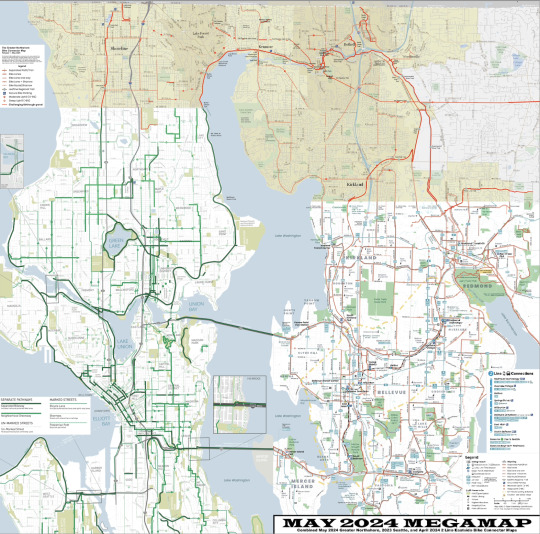
So not only did I finish the Greater Northshore Bike Connector Map to connect the Seattle and Eastside maps, I decided I would ALSO make a MEGAMAP of all three maps since King County stopped maintaining a map over 10 years ago which makes this the biggest maintained King County bike map since then.
Greater Northshore Bike Connector Map (May 2024)
May 2024 MEGAMAP (Northshore May 2024, Seattle EOY 2023, 2 Line Eastside April 2024)
let's gooooooooo!
#biking#maps#bike maps#seattle#northshore#shoreline#lake forest park#kenmore#bothell#woodinville#juanita#kirkland#bellevue#redmond#bike map
23 notes
·
View notes
Photo
The Importance Of Mapping Bicycling Data
1 note
·
View note
Text

Do I Really Want This Medal
#there's a challenge map leave me alone!!!#this is ass!! this is terrible!!! jesus on his infamous bike!!!!#arknights
66 notes
·
View notes
Photo

All the bike lanes in the Netherlands.
418 notes
·
View notes
Text
Rolling With Difficulty as texts I have saved on my computer for some reason
(i drew every day for like a month straight and burnt out so have this nonsense instead)
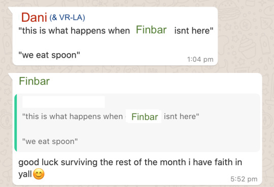

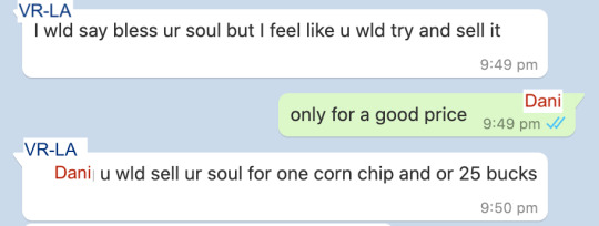

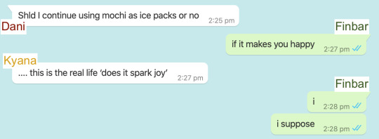

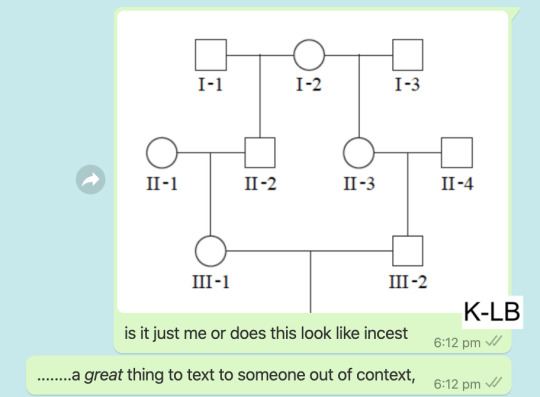
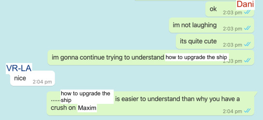
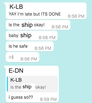
#rolling with difficulty#dani rwd#finbar rwd#kyana rwd#vrla rwd#vr la rwd#which of those is the correct tag. like genuine question#k lb rwd#maxim rwd#i had one that was k-lb and c-ra but it got eaten by tumblr somehow#anyway sorry for the wildly varying formatting these are amassed across like 4 years and god knows how many messaging apps#if you want context to 'we eat spoon' me and my friend bought a bean curd and for some reason we thought the spoon was made of like#that biodegradable/technically edible plastic material#i mean idk what it was actually made of but it sure as shit wasnt edible because i was the one who tried#same friend is the one who almost died on a highway with me because we misread google maps and tried to push our bikes#along a highway shoulder for 30 minutes at like... 12 in the morning#selling your soul for 25 bucks is a joke from when i was playing fallen london and actually sold my soul in game for about that much#im realising now that i may very well be the dani of my friend group and i have no idea how to feel about that#the original of the crush on maxim one was me @ my arospec ace friend who loved making fun of me for my dumb crushes#so it was like. my one rare chance to take revenge because while they were Suffering with that *i* was studying for a competition! lmao#i should do these more often like i do these for all my fandoms and its always a blast every time
57 notes
·
View notes
Text

TRACTOR BIKE
(and Ryss' karakul herd and @verysmallcyborg's Fornax)
#TRACTOR BIKE#sorry i am excited about the tractor bike#ffxiv#gpose#ryssrael#fornax#FUN FACT#if you move a 2 seater mount while someone is in gpose... it interrupts the gpose#rip renee i thought it'd be really funny if i drove to the other side of the map and you came out of gpose in a totally different place#☀️🌟
26 notes
·
View notes
Text
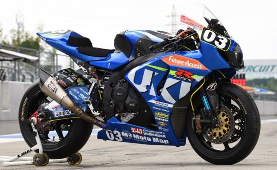
Suzuki GSX-R1000 | Moto Map Team | 2017
#motorcycle#suzuki#gsxr1000#moto map team#sport bike#racing#motorsports#ride hard or go home#built for speed#experience speed#2017#moto love#lifestyle
15 notes
·
View notes
Text
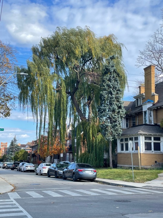
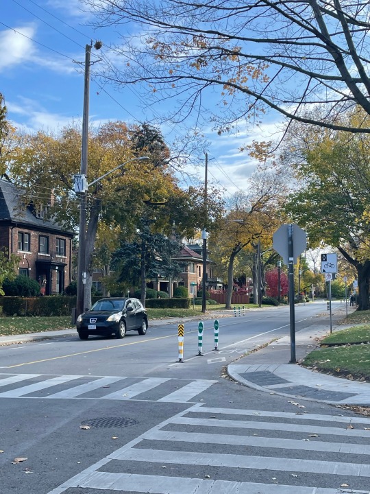
Since there were no notes, RC1 of the Greater Northshore Bike Connector Map is the release! This map connects the City of Seattle maintained bike map (latest EOY 2023) and the new 2 Line Connector Map on the eastside, covering northwest King County.
The biggest addition to this version is an entire new category of routes showing where people bike when there isn't bike infrastructure in place. It's particularly useful in rural King County, but is also helpful a few other places, like Lake Forest Park, and it also shows how infrastructure "islands" connect together in real life.
#seattle#bike map#bike maps#king county#shoreline#lake forest park#kenmore#bothell#biking#bike#woodinville#juanita#redmond
4 notes
·
View notes
Text
my post about the baby eating a tomato at the farmer's market has elicited mostly very positive reactions but there have been a couple of comments (since the containment breach) along the lines of "and then everyone clapped." and obviously I have no plans to question the authors of those comments but I am genuinely curious about what part of that story seems implausible to them. the tomato guy giving a baby a tomato for free? a baby happily eating a tomato? bystanders finding a tomato-eating baby adorable?
like it's a cute story sure but it doesn't seem all that credulity-straining to me. it's like if I said "so cozy in bed right now in my jammies" and some random stranger was like "suuuuure you are 🙄"
(I am. btw)
#psir#also someone was like 'i would not have stopped and said aww. i would have kept walking. to me babies eating messily is gross'#i was like... ok well i'm glad you told me. otherwise i might have come to your house with the baby and knocked on the door#and made you watch him eat a tomato#it's like on google maps when people are like 'does this location have a bike rack' and someone goes 'i don't know'#...then i wasn't talking to you???#anyways i shouldn't cavil. almost nobody has gotten really weird and hostile on the nephew posts
65 notes
·
View notes
Text
i’ve been biking to work since the buses have started striking and it’s kind of beautiful.. i forgot how nice it is to rely on my body to get me from point a to point b and i took it slow and stopped at my favourite park for a bit.. it was so nice
#google maps said it’s a 30 minute bike ride but it took me more like an hour#but that’s ok it was so wonderful..#life
7 notes
·
View notes
Text

#wherever I go for a bike ride google maps will tell me to go thru alleys even though there’s perfectly good quiet streets available#it’s become a running joke with my sister#but today I found this painting in a dingy alley and for the first time it was worth it
21 notes
·
View notes
Photo
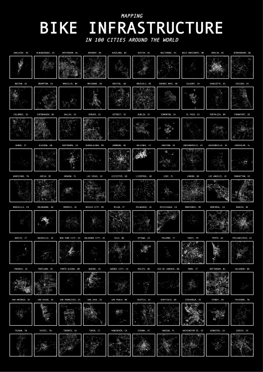
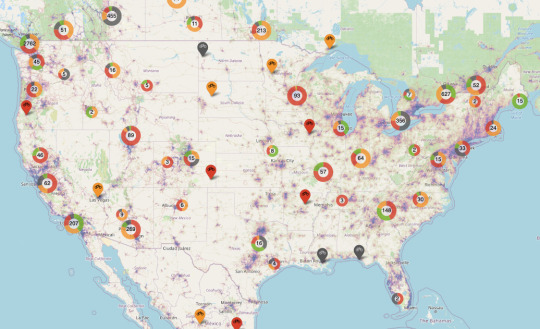
Mapping Bike Infrastructure in 100 Cities Around the World
by u/UnrequitedReason
With the surge in bicycle use over the course of the COVID-19 pandemic, municipalities around the world are experiencing a unique opportunity to transform urban spaces to be more cyclist-friendly. This includes building protected bike lanes that make it easier for cyclists to share busy city streets with cars.
Bike network density is the most important factor in encouraging people to ride bikes, with each standard deviation (about 1 kilometer of bike infrastructure per square kilometer) associated with an additional 150 bike commuters per 10,000 commuters. Bike network connectivitity is the second most imoirtant factor, with one standard deviation correlated to an additional 37 bike commuters per 10,000 commuters.
By using a combination of webscraping and computer vision techniques, we mapped bike infrastructure in 100 cities around the world, making it possible to view differences in network connectivity and density,
Source: Google Maps Tools: Python, HTML
Note: Data was limited to cities with bike lane data on Google Maps.
All data, code, and images for this analysis can be found here.
203 notes
·
View notes
Photo
First Bike Ride
It was 15 degrees and sunny today after work. My regular route is 9km. I was slow. Let’s blame the wind.
18 notes
·
View notes
Text
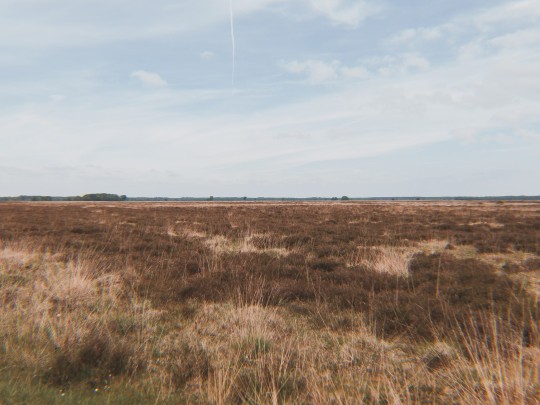
bike ride today in my favourite part of my local area :-) (dwingelderveld, drenthe)
6 notes
·
View notes
Text
I feel so terrible for having used delivery services for ordering groceries on so many separate days while being too sick to go to the grocery store, instead of planning ahead and ordering a larger amount at one time, but excuse meeeeeee I've been too poorly to think clearly and haven't really felt like eating much of anything, also I'm terrible at planning grocery shopping even when I'm healthy, so doing that while feeling like a moldy garbage bin is like, ten times as hard 😭
#my closest grocery store used to be 100 m away but they've literally JUST shut it down so i can't go there anymore 😭#the next closest is a 5 minute bike ride away but i'm in no shape to be riding a bike#especially when there's a deathly uphill on the way back#and going there by bus seems a little...silly (because it's so close)#and anyway i don't want to go wandering around a huge supermarket feeling and looking and sounding like this 😭#so please forgive me for being so horribly unfriendly to the environment and making the wolt person drive back and forth 😔#(at least according to the map where i can follow where the delivery person currently is they're using a car instead of bike)
8 notes
·
View notes
Photo
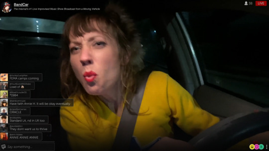
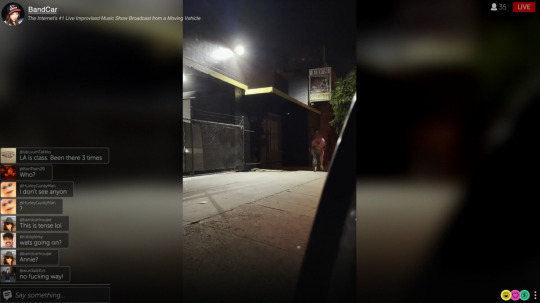
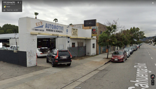
Dashcam
Rob Savage. 2021
Naked Man on Bike
5534 Cahuenga Blvd, North Hollywood, CA 91601, USA
See in map
See in imdb
#rob savage#dashcam#annie hardy#naked man on a bike#toluca terrace#north hollywood#found footage#movie#cinema#film#location#google maps#street view#los angeles#california#united states#2021
12 notes
·
View notes
Last Seen Blogs

dblbcescka
Princess Ericka

thepromchemist
The Highly Caffienated Elephant

tsa3cctl566
Untitled

blogcuahung
Untitled

nhapmondautu
Sans titre