#Alabang Hills
Text
NLCOM helps alleviate the loss and despair of fire victims in Barangay Pilar Village, Las Piñas City
Recently in the City of Las Piñas, New Life Community Care Foundation International, Inc. (NLCOM) – the compassion arm of New Life Philippines located inside Alabang Hills Village in Muntinlupa City – sent a team to help fire victims in Barangay Pilar Village recover by providing them more assistance and this includes the conducting of Psychological First Aid.
To put things in perspective,…

View On WordPress
#Alabang Hills#Alabang Hills Village#AMPC#Amplified Bible Classic Edition (AMPC)#Asia#assistance#Barangay Pilar#Barangay Pilar Village#Be the fearless and aggressive church of Lord Jesus#Blog#blogger#blogging#Book of 2 Corinthians#Book of Proverbs#Book of Psalm#Book of Psalms#Carlo Carrasco#Church of Lord Jesus#City of Las Piñas#City of Muntinlupa#compassion#donation#donations#Faith#fire#geek#God#Heavenly Father#Holy Bible#Holy Spirit
0 notes
Text

Preselling Condos, Houses, Lots, Offices for sale | Spire Group PH
#Pre selling Condo in McKinley Hill#Pre selling Condo in Ortigas Center#Pre selling Condo in Quezon City#Pre selling Condo in Alabang#Pre selling Condo in Pasig City#Pre selling Condo in Pasay#Pre selling Condo in Mandaluyong#Pre selling Condo in Eastwood#Pre selling Condo in Muntinlupa#Pre selling Condo in Rockwell#Pre selling Condo in ARCA SOUTH
0 notes
Text
The Triple Treat: Satisfying Your Cravings with the Food Trinity

📍 133 Beverly Hills Dr, Subd, Taytay, 1920 Rizal
April 7, 2024
With a mouth-watering dishes, cozy Filipino ambiance and a relaxing hymn of peaceful silence. A bee inspired café have been arise at Casa Mellifera, a cozy café based in Taytay Rizal that serves different dishes and snacks that will surely satisfies your taste buds. One of its unique products is the bibingka waffle, top with fragrant butter and side with hot chocolate dipping sauce, the tasty butter at the top of the soft waffle truly compliment with the dark sweet blend of its chocolate sauce. With the photo facing upward, the aesthetic bind of its table cloth truly blend with the delicious looking waffle that making it more delicious as it looks.

📍 SM Mall of Asia, Pasay, Metro Manila
April 9, 2024
Next is what would be the purpose of the appetizer without having the main course. As the next photo shown, the photo is presented on a very clean white quarts table this compliments the spaces and the colors of the food, that eventually makes it more appetizing. With its magnificent dishes, Tuan Tuan Kitchen is also famous for its dishes like Ramen, Katsu Curry, Gyudon, and Snow Buns. They are also known as a go-to place for the person who loves to jump their taste buds for having a Japanese cuisine.

📍 Daang Hari Road, Alabang West Parade, Las Piñas, 1750 Kalakhang Maynila
April 10, 2024
Finally, is when we talk about classics, classic dishes are very popular especially for those western countries with a very big influence on food the heart of the southies represents “Brotzeit”. Brotzeit serves an Authentic German Food & Beverages since 2006. In the photo, we have a Holzfaller Fruhstuck a breakfast of champions, Fladen Bayrischer Art a Bavarian style fladen, and Fladen Bayrischer Art a bavarian style fladen with a very generous portions of servings at Brotzeit, it is also an instagrammable and worth to feature at your social media accounts, but don’t forget to add their unique food menus at your sudden food travel list. At the very least, great food is a great life so get yourself ease and satisfy your cravings with these heavenly delicious goods. It is indeed that fondest memories are made gathered around the table.
Theme: Food and Drink
8 notes
·
View notes
Text
“The Only Underground Cemetery in the Philippines”
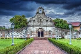
The Nagcarlan Underground Cemetery is probably Laguna's most well-known attraction. In the Philippines, it is the only underground cemetery. The National Historical Commission is in charge of maintaining the location, which is open every day except Monday.
From the entrance, a pathway leads to the chapel, where funeral masses used to take place. The grave is more modest than I anticipated. The floor tiles are supposed to be the first tiles that were utilized when it was worked in 1845.
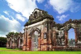
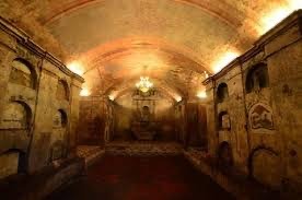
Father Vicente Velloc, a Franciscan friar, had a chapel constructed in Nagcarlan in 1845 on the sloping hills close to Mount San Cristobal's base. Above ground, the church is encircled by a Baroque cemetery that is made up of circular niches that are four floors high. The niches doubled as the cemetery's walls and functioned as common public burial plots. For Spanish friars and other notable individuals, an underground crypt beneath the chapel was set aside as a more restricted burial location. A staircase on your right as you enter the chapel leads to three-level high tombs.


The Nagcarlan Underground Cemetery functioned as a gathering spot for the local anti-Spanish rebels during the Philippine Revolution between 1896 and 1898.

HOW TO GET THERE:
Take a bus headed for San Pablo, Laguna, if you're a self-directed traveler, to get to Nagcarlan Underground Cemetery. You can also board a bus that travels through San Pablo on its way to Batangas or Lucena. These buses can be found in Pasay City at the intersections of Gil Puyat Avenue-Taft Avenue, Buendia Avenue, or EDSA-Taft Avenue. They also travel through Alabang and Muntinlupa. Depending on traffic, the distance can be traveled in 2 to 3 hours.

And if you have arrived in San Pablo City Laguna,Go to the jeepney terminal for those headed to Nagcarlan or Liliw.Request that you be dropped off at Nagcarlan Underground Cemetery from the driver. A 35-minute journey takes place.


NO ENTRANCE FEE
to enter the Nagcarlan Underground Cemetery. However, contributions for its upkeep are strongly encouraged.
OPEN HOURS:
8:00 a.m. to 4:00 p.m., Tuesday through Sunday.
1 note
·
View note
Text
10 + 1 Grand Fondo Bike Rides in Seven Months
Hello people, my name is James. I am neither a pro cyclist nor a barista, so don’t take my opinions on either subject too seriously. I just love brewing/drinking coffee and riding my bike; I think the two are a match made in heaven. Not surprisingly, a lot of people think so too.
To start things off, allow me to chronologically share 100-km bike routes I’ve taken within the past seven months of cycling.
1. Lower Antipolo, Caloocan, North Caloocan. 101 km.

This was my first metric century ride, a month into cycling. I had planned a coffee delivery route and a schedule and was fully expecting to make it to each stop in good time. On paper, it didn’t seem that hard. How naïve I was. What the map doesn’t tell you is how horrible the roads are, how hot the weather is, or how crowded with trucks some streets are. Add to that the fact that Komoot is not a good on-the-fly navigation tool, and I was on the fast lane to disaster. Getting lost in a totally janky area on the bumpiest roads was not fun at all.
I was dying, but I kept at it. I was a noob who refused to admit defeat. After getting out of the sticks known as North Caloocan, I hit the mythical wall and bonked. As I thought that things couldn’t get any worse, it rained. Thankfully I was close to a Jollibee so I refueled and let the rain pass. Later that day, I did laps close to home just to complete 100 km since I was just a couple of km short.
4/10. It was totally my fault for being unprepared, but this ride sucked. I’d give it a 3/10 but there’s a bonus point since it was my first long ride.
2. Tagaytay via Daang Hari and Paliparan. 140 km.
Tagaytay seems to be a test of courage or rite of passage that every budding cyclist has to undertake. And it is quite an undertaking. However which way you slice the cake, you’ll have to climb. If gradients aren’t your thing, you’d quickly question why you’re doing this in the first place.
Like every long ride (I know this now), it requires adequate preparation, i.e. time, weather conditions, road and traffic conditions, hydration and snacks, and physical fitness. I was more prepared than I was the first century ride, but we started late and therefore finished late.
I had good company during this ride and being with them made the exhaustion bearable. It was hot on the way up and the traffic was dreadful on the way back, but we survived thanks to Pocari Sweat and Choco Mucho.
7/10. This was a good “beta test” for me. Could’ve easily been an 8/10 but the Mang Inasal at the roundabout ran out of inasal. I got the last piece, but Jilson and Dan had to settle for something else.
3. Pililia Windmills via Binangonan. 114 km.
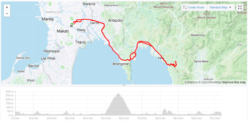
This was my first time riding with a large group. There were seven of us. As this was in the same week as my ride to Tagaytay, I came into this fairly confident and with high morale (aside from the fact that I was the seventh wheel). It slowly got lower as mishap after mishap occurred; a flat tire, a broken chain, another flat tire...
On this ride, I learned that it’s essential to have an idea of each person’s capabilities so you can set the right pace and adjust where and when necessary. We all had different types of bikes, different fitness levels, and different experiences biking on the road. It couldn’t be helped that some were dropped and others had to wait. In this regard, it was a tough and long day and toward the end of it, I was itching to be home.
6/10. At the time, climbing Pililia felt like treading through mud, but making it to the top was very rewarding. Good food and good conversation made up for aching legs.
4. San Jose Del Monte (Fake Eiffel Tower) via McArthur Highway. 111 km.
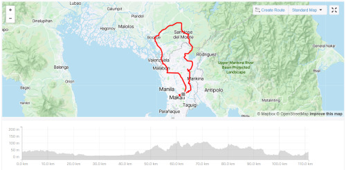
This started out as an easy ride on flats. We were all prepared and even the traffic and heat didn’t hamper our confidence. Once we were out of the highway and passing through barangays, the views became nicer. There was less pollution too. We saw the fake Eiffel Tower and met a couple of lolos who were still going strong. It was a good day that was only made better by a tasty, cheap, meal.
By this time, my fitness level and technique were steadily improving, and I was starting to enjoy climbing more. The way back was hilly, but it was no trouble for me. The cause of stress was, as usual, the traffic on the way back. If you can help it, don’t ever pass through Caloocan! It’s the worst. Commonwealth is also a horrible place to ride a bike.
7/10. Good times with good friends! The stop-and-go, clip-and-unclip traffic was a bummer. AG cramped up, but proud of him for powering through it and clocking in his first 100-km ride.
5. Tagaytay via Nuvali and Cardiac Hill. 136 km.
Second time riding to Tagaytay. This time, we rode out early. Iver and I met up in Makati and rode straight to Nuvali where we were to meet the rest of the guys. All was going well and we were maintaining a steady pace, till we made a mistake and met an accident.
Instead of making a right to Greenfield, we went straight to CALAX. We were none the wiser, so it felt strange when workers started screaming at us. While Iver was looking at them, one of the security personnel near the toll gate stepped in front of me. I had to stop and since Iver was still looking at the guys yelling at us, his front wheel hit my rear and he went over the bars. When I felt the impact, I looked back and I kid you not, I saw him go over in slow motion! He landed on his shoulder and he burst an eyebrow; thank God for helmets!
As he sat with his blood dripping on the pavement, I was torn between taking a photo and making sure he was okay. I went with the latter, but later on, he told me that I should’ve snapped the photo. What a guy!
Cardiac Hill was a bit of a challenge. In fact, it was the hardest part of the way to Leslie’s. I stopped at the base of the hill for a moment just to steel myself and went up the hill without stopping. Slowly, but surely.
8/10. As usual, the traffic was the worst. Sorelle was in so much pain that going all the way back to Manila on two wheels was out of the question. It was getting late too, so we decided to stop in Bacoor and take a Transportify back to manila. The first and only time (so far) I did the forbidden technique, but it was the smart thing to do.
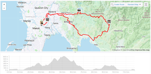
6. Pisong Kape via Sumulong and Teresa. 103 km.

One of those rides where we didn’t have a fixed destination. We just wanted to go up Antipolo and down Teresa and back, and maybe climb to the windmills if we felt like it.
A fairly easy ride up Sumulong Highway and a fun time descending to Teresa. It wasn’t all good vibes though, since one of the guys punctured a tire on a descent, which we think caused his crash. He was okay, but his brand new cycling jersey wasn’t.
We made it all the way to Tanay and had breakfast silog there, and decided to head to Pisong Kape at the base of Pililia. When it showed signs of rain, we decided to turn back. More mishaps. Someone got a flat, and another one dropped a chain and had FD issues on the way to the climb to Antipolo from Teresa. We got split up at some point too.
5/10. This is what’s referred to as a bad juju ride. Hot, traffic, and a ton of things we’d rather not experience on the road. I stopped and waited for a good half hour at Decathlon Masinag, but left and rushed home since I needed to poop, lol.
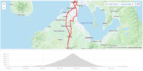
7. Nuvali via a straight and narrow road through barangays and National Highway. 102 km.

It was the day before heading to Baguio for the holidays and I made brunch plans in Alabang with Elle. I was really excited to bike to her but more so to see her. If I left the house late, it would be hot and traffic would be terrible, so I decided to leave at dawn and make a long ride out of it and go all the way to Nuvali.
I didn’t want to take the service road like last time, so I followed the map through I don’t even know what road this is. All I know is that it was straight and narrow and clogged with tricycles. It spanned several barangays in Pasig, Taguig, Pateros, Sucat, Alabang, etc., and eventually led me to the National Highway.
It was all flat and this was my first ride on carbon wheels. I was riding solo, so I could go as fast or as slow as I wanted. I made it to Nuvali in 2:20. After resting for half an hour, I took the same route to Alabang and was there in 1:30. On the way back, I took the service road.
ELLEven/10. The route sucked both ways but it was a good day with Elle. What else can I say?
8. Macabebe Beach via Obando. 175 km.
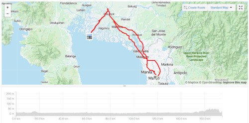
The flattest route I’ve taken, both literally and figuratively. Levi and I rode out from the Mandaluyong circle at 3:30 AM and cut through Manila to get to Monumento. From there, we opted to avoid McArthur Highway and instead took the more scenic, Obando way. I say scenic, but in reality, all we saw was black. We only stopped to buy pandesal and to navigate. As the sun rose, we found ourselves getting closer to the longest 24 km of my life.
It was a hard left turn from the highway about a km from the arc of Pampanga. The streets were narrow, and we passed through about four barangays. There were a lot of cars on the road, which was quite irritating because we had to stop when they did. The straights never seemed to end; in fact, I went “Look Ma, no hands!” for about what seemed like a couple of km. As we neared the beach though, we were rewarded by breathtaking views on both sides. The beach itself was mediocre and we stayed only for half an hour to eat our pandesal.
The way back was more difficult. You guessed it, it was due to the heat and the traffic and the horrendous roads in Bulakan. We stopped for coffee and to shield ourselves from the burning sun a few times, but overall we kept a steady, okay let’s be honest, frantic pace. We got to Makati a little over 1:00 PM. Levi and I made it in less than 10 hours. With stops. I was spent.
9/10. This was quite an experience. I always wanted to try a purely flat ride, so I did. It was boring. I’m not saying it was easy -- far from it. Being on flats takes a certain type of mindset and discipline, not to mention you have to be strong. The effort it takes to get from point A to B in a specific time is the same back and forth. Unlike climbing, there’s no descending that comes after. You can’t freewheel down the mountain and recover. I learned a lot on this ride, one of the things being that I like gradients more than watts.
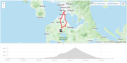
9. Tagaytay via RevPal, Sungay, and Sampaloc. 110 km.
Tagaytay take three, route three. This time, we drove to Alabang and started there. What we should have done is start in Nuvali. But Luz insisted on starting in Alabang. This was not a good idea, lol. I want to preface this with the statement that as it was, the planned route was a killer. It didn’t help that I had little sleep and had a hard workout the day before. Another bad idea.
Let me give you a TL;DR: We climbed up RevPal from Nuvali, went down to Taal via Sungay, and climbed back up to Tagaytay proper via Sampaloc. From there, we went back down to Nuvali via Cardiac Hill.
Easy on paper, not so much in action. RevPal is steep, but not impossibly difficult. Part of the difficulty is avoiding all the other cyclists occupying the road, weaving their way up (known as nag tatahi) while staying out of the way of cars. At some point, my right knee started acting up, adding to the difficulty level of the ascent.
What was unexpected though was how scary the descent on Sungay was. I won’t get into detail, but suffice it to say that we should have taken it as a sign when we saw that other riders were dismounting so they could walk down... That said, what an adrenaline rush!
The climb up Sampaloc was tough with an aching knee (which by the way has no ACL), but thankfully there were a lot of trees and cover. Not my best performance, but I still made it up without stopping. The descent from Tagaytay proper was meh. From Nuvali, we rode with our friends who had the brilliant idea to park there. I slept on the way home.
9/10. I officially dubbed our group Mountain Goats after this ride. We have a lot of rides that are less than 100 km, but we often reach over 1000 meters of elevation gain. On this outing, we hit 1,640. I wonder how I’ll fair if I do this again in good condition.
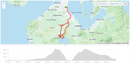
10. Sierra Madre Loop via Teresa. 118 km.
I think this is the most fun Grand Fondo I’ve done. It’s the highest I’ve climbed in the fastest time. 1740 m in 5:43:28. Arguably the most fun I’ve had on a bike. The climbs could kill you if you don’t pace yourself, but the descents were so rewarding.
The only sucky part about this ride was motorcyclists who go up on their underbone bikes and bank the corners like they own the place. They don’t signal when they turn. They take sudden U-turns. They overtake you, swerve, and suddenly stop in front of you. They are a danger to themselves and others. In fact, Levi mentioned that when she was there, a guy on a Mio overshot a corner and he and his bike went under the guard rail onto the cliff. Thank God he was alive.
10/10. The chicsilog was made even more delicious by the view from the top of the mountain.
10 + 1. Laguna Loop. 192 km.
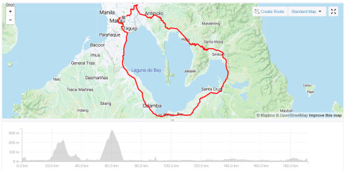
Laguna Loop is fun they said. You should try it, they said.
Well, I did. And I hated it. THEY LIED. This is by far the worst Fondo I’ve done. It was fun climbing Antipolo via Cabrera Road. It was fun going down Teresa. It was fun going up Pililia (which was so much easier than the first time). It was fun going down Mabitac. And that’s where the fun ended.
From that point, it was flat. It was hot. It was traffic. And the drivers were so bad. By bad, I mean jempoy bad. By jempoy bad, I mean trying to ride you off the road and driving at your side with their window down to argue with you. It was not fun. Have I said that it wasn’t fun?
2/10. Not gonna lie, I don’t even consider this ride as a Grand Fondo (which is why it’s a +1 and not a solid 11); the only part of the ride that counts is the first part with the ascents and descents. The rest was just really getting it over with. One point for that first part and another for the good company. WILL NEVER DO THIS AGAIN.
Okay, that’s it. It’s quite a long post but it should be okay since it’s the first one? I hope you enjoyed my unedited reviews of my 100-km rides. Again I’m not a pro so don’t take these scores seriously. Ride the routes yourself if you can and let me know what you think!
1 note
·
View note
Photo


Mayon Skyline
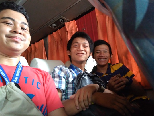
Legazpi-Tabaco tour gone wrong talaga to e. Hahaha. Kawawa si Prince, lahat ng gusto niyang mapuntahan nung araw na yan, di niya napuntahan dahil samin ni Riza. Hahaha.
August 16 ng gabi kami umalis sa Cubao, 9pm. Sumabay kami sa Lazyboy pa-Naga kasi ewan ko rin bakin. Haha. Dalawang bus na Lazyboy lang kasi ang available samin na pang 9pm last trip na kasi yun. E ayaw namin mag hiwa hiwalay. Haha kaya sumabay kami sa pa-Naga, tapos balak namin from Naga stop over magpapaiwan na kami dun para makasakay sa pa Legazpi syempre may mga bumama din dun na Naga lang. E very wrong agad, kasi na-late kami! Haha.
So from Naga control (kung saan doon na gumagarahe yung mga end point ng Naga, bumalik kami sa CBD yung main terminal ng Naga. Lokal ng bus company namen syempre ulit sinakyan namin, from CBD, sumakay nanaman kami ng lokal samin tapos bumaba kami ng Ligao.
Ayun na! Kawa-kawa hill sana pupuntahan namin, e anong oras na 9am na ata yun, ang init init na. Bigat pa ng mga bag namin tapos etong si Riza, mula Alabang palang gusto na umuwi haha e usapan namin nun overnight gusto niya mag balikan lang. Ano pa mapuountahan namin? Hahaha. Edi ayun na, tinotopak na rin ako kasi pagod na ko tapos gutom pa. Tapos si Riza uwing uwi na dahil sa boyfriend niyang kaaway niya that time. Lol
Kumain muna kami sa Jollibee sa Ligao. After kumain, sumakay na kami ng jeep pa Legazpi dapat e kaso di namin alam kung saan yung sakayan haha. Tabaco lang yung madaling access, e via Sabluyon pala yun, nag Mayon Skyline kami.
Wala rin kasing matinong itinerary to si Prince isa ring magulo e. Hahaha. Kamot ulo na nga siya samin ni Riza. Sobrang topak ko rin kasi init na init ako tapos lakas pa ng loob ko mag long sleeve, feeling nasa Tagaytay lang. Hahaha. Tapos lalo akong tinotopak kasi kaya ako sumama para magkaron na ko ng chance na magkita na kami ni Joemar. Nagpapasama ako sakanila niyan.
Siguro mga 12noon na, bago kami makalabas ulit ng Sabluyon, hindi na rin makapag isip si Prince ng next na pupuntahan namin kasi tinotopak parin kami ni Riza. Sabi ako ng sabi, “dapat kasi nag Legazpi muna tayo” “Dapat kasi inuna muna natin dito. “Dapat kasi ganito, ganyan” haha dami kong sinasabi hanggang sa inabot na kami ng hapon pupuntahan pa sana namin yung Sumlang lake kaso di rin namin alam kung saan ba sasakay at bababa, tapos kulang na kami sa oras. Hanggang nasa Camalig na kami, binalak nila maghanap ng Pancit Bato. Kaso Kinalas yung nahanap nila haha. Hindi ako kumain kasi nga topak na talaga ako, ayoko kasi pauwiin si Riza, saka dipa kami nagkikita ni Joemar. Hahaha.
Siguro mga alas-4 na ng hapon yun humiwalay na si Riza samin, nagpa Naga na siya kasi dun siya sasakay pauwi ng Cubao. Tapos kami ni Prince nagpa-Legazpi na. Dun sana balak ni Prince matulog sa quarters namin sa Legazpi, ang problema bawal daw ang lalaki. Kamalas malasan nga naman talaga ni Prince sa amin hahahaha. Tapos dun na kami nag kita, finally ng boyfriend ko si Joemar. nag meet din sila ni Prince.
Since bawal pala si Prince sa Legazpi bumalik siya ng Naga Control, may quarters din ang mga employee dun, dun na sana niya balak mag overnight para kinabukasan makapag gala kami, dun kasi ako kila Joemar e. E malas nga, walang susi sa control haha. Balik nanaman siya ng CBD, kasi dun naka duty si Ate Jing yung kwork din namin na teller. ayun, malas niya talaga haha, natulog sa boyfriend sin si Ate Jing hahaha. Ending, umuwi nalang din siya. Haha. Disaster talaga hahaha.
But atleast ako,
finally after 6 months of waiting, nagkita narin kami ni Joemar, nayakap at nahalikan ko rin siya after all the screen hugs and kisses :)
In the end,
Legazpi-Tabaco tour ended well for me. And worth it. ♥
9 notes
·
View notes
Text
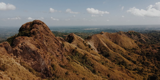
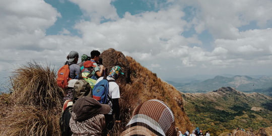
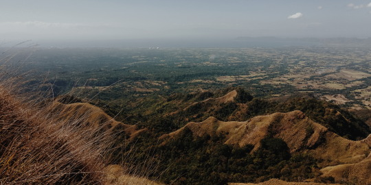
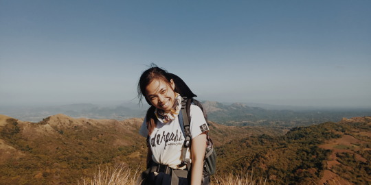
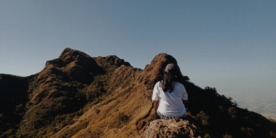
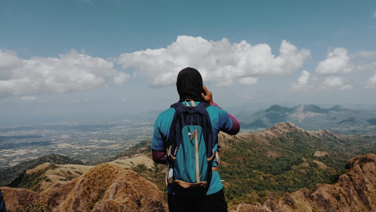
Womanlalaboy's Travel Guide to Batulao
SUMMARY
Elevation: 811+ MASL
Jump- off: Evercrest Golf Course, Nasugbu
Days / hours to summit: 1 day / 2-4 hours
Climb: Minor
Difficulty: 4/9
Trail class: 3 with 60-70 degrees assault
Features: Open trails, rolling slopes, scenic views of Batangas
Type of Travel: DIY
Date of Travel: most recent is Feb. 2019
Duration: 1D
Budget: P 600 - P 700
Batangas sure is rich in natural treasures- from beaches to waterfalls to history and culture, and to mountains that are clamored about by most climbing enthusiasts. A day or two wouldn’t be enough to sample everything Batangas has to offer, but climbing Batulao can somehow give you a glimpse of what paradise is.
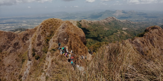
Batulao is my first official climb, but we were welcomed by a typhoon during our first time hiking, so we vowed to come back on a sunny day and witness the majestic views of Batangas landscape. Our most recent climb was Feb. this year during the long weekends. There were over a thousand climbers that time and we’ve watched how the paths crumble with every step. It was concerning to see that much people in a hike that’s supposed to give you a moment to breathe and contemplate life. I’ll publish a separate write up for the environmental impact of over- commercializing places like Batulao. For now, we’ll focus on how you can get around hiking this beautiful mountain, but please to avoid doing your hike on weekends and during holidays.
ITINERARY
5:30 AM - Meet up at Pala-pala terminal
7:45 AM - ETA Evercrest
8:00 AM - ETA trail head
8:30 AM - Start Trek
11:00 AM - Summit
12:00 PM - Start Descent
2:00 PM - ETA trail head. Lunch
5:00 PM - ETA Pala-pala terminal
6:00 PM - Imus
From Manila, it will only take about 3-4 hours to reach Batangas and you wouldn’t need to transfer from one bus to another so basically, it’s not that hard to get to Batulao and you wouldn’t need to worry so much about the travel time unless it’s around holidays and long weekends. If you will do a DIY hike, you’ll have to endure the Manila traffic. Since buses will have to take E. Aguinaldo Highway, you’ll have to pass through traffic prone areas like Bacoor, Dasmariñas and Tagaytay. It’s still best to allow an allowance of another hour for this case.
HOW TO GET THERE
Commute from Manila: Board any bus bus liners bound for Nasugbu, Batangas from EDSA, Quezon City, Taft Avenue, Pasay and in Cubao. Drop off at Evercrest Golf Course and ride a tricycle or walk to get to the trail head. DLTB bus bound for Nasugbu in Buendia Station costs around P 111.
Commute from Bacoor or Imus, Cavite: Ride any bus bound for Nasugbu, Batangas. The bus liners are usually found along Emilio Aguinaldo High way from Waltermart Dasmariñas as well as from Silang. You can also ride a van from Pala-pala Terminal.
You can simply tell the bus driver or conductor to drop you off at Evercrest or just inform them that you’re off to Batulao. From Evercrest, you can either walk your way to the trail head or hail a tricycle for P 100 per way (good for 4 pax).
Private car via Emilio Aguinaldo High way: You will have to pass through Imus, Dasmariñas, and Silang. Simply continue til you reach Batangas-Cavite boundary. Take the road marked by an arc, leading to Nasugbu, Batangas
Private car via SLEX: take Sta. Rosa Exit and continue driving along Sta. Rosa-Tagaytay Road. When you hit a fork, you’ve reached the Batangas-Cavite boundary. Take the right road marked by an arc, leading to Nasugbu, Batangas.
Private car via CAVITEX: Drive along Antero Soriano Highway. You will pass through Kawit, Tanza, Naic, and Ternate then drive through Mt. Palay Palay National Park and Kaibiang Tunnel to reach Barangay Papaya and then Barangay Calayo and Nasugbu town proper.
Private car from Alabang: Take Daang Hari, turn left to Paliparan, right to the junction leading to Carmona, left to Aguinaldo Highway up to Tagaytay junction leading to Nasugbu. Another option is to Take Daang Hari, continue on Daang Hari extension past the dikes, turn left at the end and go towards the San Miguel and Purefoods plants along Governors Drive. Turn right when you reach Governors Drive and continue until you reach Naic, then turn left and on to Puerto Azul, Caylabne.
OTHER POINTS OF INTEREST
Some experienced climbers do more than just hiking Batulao. Batangas is rich in mountains to climb, so some hike one or two other mountains apart from Batulao. 3 of the nearest mountains that can be a part of a probable twin hike or trilogy hike are Mt. Talamitam, Mt. Apayang and Mt. Pico De Loro.
Mt. Talamitam
Jump-off point: Sitio Bayabasan, Brgy. Aga, Nasugbu (KM. 83)
LLA: 14.1158° N; 120.7577° N; 630 MASL
Days required/ Hours to summit: 1 day / 1.5-2.2 hours
Specs: Minor climb, Difficulty 3/9, Trail class 1-3 with steep assault (100m)
Layon Bilog / Layong Bato
This area can be found at the foot of Mt. Talamitam (considered as Mt. Batulao’s “little sister”). You can wash up by the river or do rappelling, but whichever you prefer to do, you’ll surely enjoy this sight.
Mt. Apayang
Mataas na Pulo, Nasugbu, Batangas
700+ MASL (Approximate)
Specs: Minor Climb
Mt. Pico De Loro
Maragondon, Cavite and Nasugbu, Batangas
Major jump-off: DENR Station, Magnetic Hill, Ternate, Cavite
Minor jump-off: Sitio Fronda, Brgy. Papaya, Ternate-Nasugbu Highway, Nasugbu, Batangas
LLA: 14° 12.855 N; 120° 38.785 E; 664 MASL
Days required / Hours to summit: 1-2 days / 2-5 hours
Specs: Minor climb, Difficulty 3/9, Trail class 1-3
Features: Distinctive spire at the summit, forests, scenic views of Cavite
Last updated: September 16, 2016
SAMPLE BUDGET
138 - Bus transportation from Pala-pala to Nasugbu and vice versa
50 - Tricycle fare back and forth (P 100 for 4 pax)
160 - Registration
100 - Guide fee per head for 5 pax (500 / guide)
50 - Batangas Lomi
___________________________________
498/head of 5 pax
Batulao is one of the most accessible mountains to hike. Due to its proximity to the metro, it’s considered a favorite among city folks who want to escape the gritty streets of Manila, but despite its fame, Batulao still is far from being perfect. For one, the water is scarce in the place and during peak season, they usually run out of water. We’ve encountered that during our last hike so instead of taking a bath, we settled to washing with wet towels before changing clothes. The bath fee at the trail head would cost P 25 per pail (timba/balde). If you need to take a piss or answer nature’s call, you’d have to pay P 10.
Another thing to take into consideration is the registration fee. Unlike most climbs, the registration for Batulao would have to take at several occasions. P 30/head (1st Registration); P 30/head (2nd Registration); P 20/head (3rd Registration); P 20/head (4th Registration); P 20/head (5th Registration); P 20/head (6th Registration); P 20/head (7th Registration).
There are refreshments and meals available at the stops and camps, but I advise that we do not patronize these. With the increasing demand for convenient food and drinks, we also raise the environmental impact of consuming these goods. The same goes for souvenirs such as bag tags. In the next few years, it wouldn’t be as fun and as magical to climb Batulao if instead of being accompanied by luscious green trees and plants, we’ll be trekking a mountain of trash.
WHAT TO BRING
Packed lunch (advised)
Med Kit/ Personal medicines
Raincoat when necessary
Extra clothes
At least 2 liters of water
Whistle
Trash Bag
Toiletries (esp. alcohol)
Trail food (energy bars, peanuts, chocolates, banana, salt)
Sunblock
Cap
Headlamp when necessary
Gloves (not required)
Trekking pole (advised when it’s raining)
Handkerchief / scarf (advised)
NOTES
No reservation is required to climb Mt. Batulao.
A large number of tourists swarm the place during weekends especially during long weekends or holidays. Avoid doing the hike during those days.
Sun exposure is notoriously acute when dry. Apply plentiful of sunblock whenever needed.
You’ll have to pass through tall grass lands so it’s better to be well-covered to avoid cuts and skin irritation.
While hiking, wear quick dry clothes and stay away from cotton fabrics and denim pants since you will be sweating profusely during the climb.
Wear a pair of hiking shoes when you climb Batulao during rainy days. The mountain can be very muddy, and hiking sandals can be hard to deal with at times like this.
Guides are required to hike Batulao with a ratio of 1 guide to 7 hikers.
There are 2 trails to choose from (old and new). However, you can talk to your guide to see if you can hike half with each trail.
If you want to stay overnight, you can pitch your tent at the designated camping sites. The guide fee, though would be P 1000 for an overnight stay. Tent rentals are also available at the registration area, but if you want to help lessen our environmental impact, opt to do a day hike instead.
Shower rooms are available at certain camps as well as at the trail head.
Water is scarce in the area so they require a fee whenever you use their toilet. At the registration area, you can take a bath for P 25/pail (timba/balde), and you can use their toilet for P 10.
Refreshments are available at stops and camps, but to avoid our environmental impact, it’s best to avoid those.
LEAVE NO TRACE (LNT): Kill nothing but time, take nothing but pictures, leave nothing but footprints.
MORE...
Also see: Batulao Revenge Hike photo sets
Also read: Panhik #2: Braving Batulao
Also read: Womanlalaboy’s Travel Guide to Gulugod Baboy
#womanlalaboy#panhik#travelguides#batulao#mountain climbing#hiking#trekking#climb#hike#mountain#batangas#braving batulao#batulao revenge hike#nature#philippine#mountains of the philippines#pilipinas#pilipino
3 notes
·
View notes
Photo

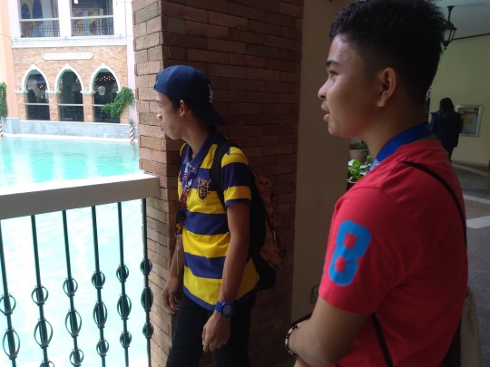
The Venice Grand Canal
Experience a romantic canal cruise a la Venice in the metro! Yes, the picturesque Venice Piazza Grand Canal Mall, complete with the iconic gondolas, has been opened to the public since last year in Mckinley Hill, Taguig City.
August 08 2018 we decide to trave at venice Grand Canal with Chester Abrasado and John Vincent Joaquin we must arrive around 9:20 am - 10:30 am while we are at the bus i feel nervous why because there is something in my mind what if we must get lost i dont what to do?
when we are in Alabang I'm still looking at my GPS were following the direction of gps and my friend saw a terminal and We ask one of a driver how we can get to fortbonifacio and the driver told the we need to ride from alabang to tenement and from tenement go to fortbonifacio while we are arriving I'm still looking at the gps and When we are in tenement we walk Start from T.U.P school we walk around 10 min and Chester Ask where are we you still following the right direction i answer "I don't No" im tired and we dont have any reference about that venice grand canal and we decide to find someone to ask and we found a security guard and that guard help us he told that you must arrive frome here to Mckinley hill... I feel thankful when i saw the Mckinley Hills sign i learn that trusting to technology is not enough you have a mouth to ask don't be shy. and i saw that I'm not the only one who excited to go their also my friend is excited.
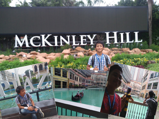
When we are in Mckinley we walk about 9 min go to Venice Grand Canal and now I realize that venice grand canal is a mall a open mo there is no entrance fee when i saw this place i feel im in real grand canal the atmosphere, the songs its symbolize the Venice From Italy I almost forgot that I'm Tired and Hungry. This is The True Paradise i Realize that Philippines is the best.. I choose the because it symbolize the purity and peace it symbolize the Philippines is not a low rank country . and this place have many tourist form other country.

This place is perfect for couple or with friends. you must found this place at Mckinley Taguig City. Joaquin told me going to this place is a great idea.
Lesson I Learn:
Trusting to Technology is Not enough you also need to ask for some trusted people.
Don't be afraid to get lost their are many people that ready to help you
8 notes
·
View notes
Photo

Merry Christmas! 🎄 As a Christmas treat we would like to give you a free cupcake when you visit us here at Alabang Hills Baratillo sa Pasko. Will be here till December 2. All you have to do is: 1. purchase a box of 3 cupcakes 2. Like this photo 3. Follow us and tag a friend! That’s it! 😊 Hope to see you all here! We are sharing a booth with the lovely @karlygabriel. Check out her amazing essential oil blends! ❤️ #theabakescupcakes #cupcakes #christmas. #iphoneonly #alabanghills #baratillosapasko #redvelvet #matcha #chocolate #vanilla (at Alabang Hills Clubhouse) https://www.instagram.com/p/BqzIw46l7cx/?utm_source=ig_tumblr_share&igshid=1tevp6ye0bm92
#theabakescupcakes#cupcakes#christmas#iphoneonly#alabanghills#baratillosapasko#redvelvet#matcha#chocolate#vanilla
1 note
·
View note
Text
New Life Community Care Foundation International, Inc. (NLCOM) feeds families affected by fire incident in Brgy. San Isidro, Parañaque
Recently in the City of Parañaque, a fire razed several homes in Barangay San Isidro which affected three hundred families.
In response, New Life Community Care Foundation International, Inc. (NLCOM) – the compassion arm of New Life Philippines located inside Alabang Hills Village in Muntinlupa City – sent a team to the location and prepared hot meals for the affected families.
To put things in…
View On WordPress
#Alabang#Alabang Hills#Alabang Hills Village#AMPC#Amplified Bible Classic Edition (AMPC)#Asia#assistance#Barangay San Isidro#Blog#blogger#blogging#Book of 2 Corinthians#Book of Proverbs#Carlo Carrasco#charity#City of Muntinlupa#City of Parañaque#CommunityReady#donation#donation drive#donations#emergency#Facebook#Faith#financial assistance#fire#geek#Heavenly Father#Holy Bible#Holy Scripture
0 notes
Photo
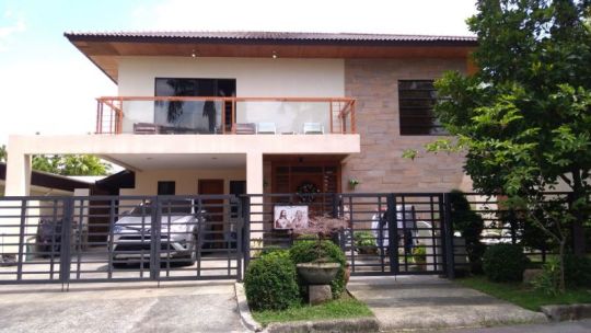

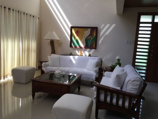


DIRECT CLIENTS OR BROKER WITH DIRECT CLIENTS ___________________ ₱ 50,000,000 ___________________ 5 Bedrooms 518 m² Floor area 568 m² Land Size ___________________ Modern House in #Alabang Hills Village, Muntinlupa City alabang hills village Cupang, Muntinlupa ___________________ Modern 2 Storey Lot area: 568 sq. meters Floor area: 518 sq. meters 5 Bedrooms 5 Toilet and Bath Powder room Maid's Room 3 to 4 Car Garage Balcony ___________________
#Alabang#alabanghills#alabanghillsvillage#alabangmuntinlupa#lotforsale#houseandlot#beautifulhouse#houseandlotforsale#houseforinvestment#oldhouseforsale#newlyrenovatedhouse#brandnewhouse#luxuryhouse#newhouseandlot#housewithpool#primehouseandlot#renovatedhouse#brandnewhouseforsale#houseandlotbrandnew#residentialhouse#beautifulhousewithview#newhousedevelopment#houseforsale#vacationhouse#beachhouse#highendsubdivision#realestatebroker#forsaleph#propertyforsale
0 notes
Photo

The best advice I can give you all is: Be with someone who is proud to be with you. Someone who will make time for you inspite of being "busy". No one is truly busy, it's just an excuse. Because if they truly value you, you will be a part of their everyday life and be one of their priorities. . . . . . #advice #loveadvice #niceysthoughts #selfie #vain #me #girl #pinay #filipina #asian #asianbeauty #beautifulfilipina #pretty #prettypinay (at Alabang Hills Village - Muntinlupa City)
#beautifulfilipina#pretty#filipina#selfie#loveadvice#me#pinay#asian#advice#girl#vain#asianbeauty#niceysthoughts#prettypinay
1 note
·
View note
Last Seen Blogs

lori-oh
Life {In-Production}

japansocietyfilm-blog
Japan Society Film Blog

canirando
CaniRando

brutallygod
TROUBLEMAKER!

ashroudedmystery
a-shrouded-mystery, he/him, LGBTQ+ ally