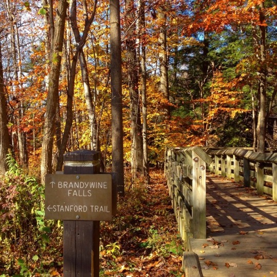
#Brandywine Gorge Trail
Photo
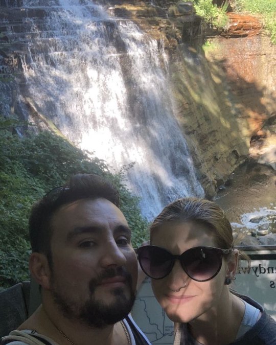
at Brandywine Falls gorge trail in CVNP https://www.instagram.com/p/ChLVw34uvGV_n_43TbhYshF5y6VDSk2yWcPX8Y0/?igshid=NGJjMDIxMWI=
0 notes
Video

flickr
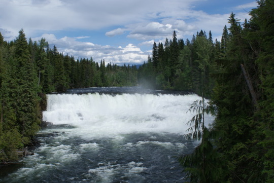
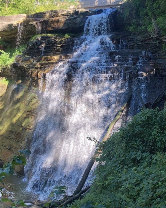
Waters Flowing Over Brandywine Falls (Cuyahoga Valley National Park) by Mark Stevens
Via Flickr:
A sideward view looking across the creek and then falls. Because of the rains the day prior, I didn't need to close have a longer shutter speed even with a variable ND filter I was using. Composing the image was a matter of lining of the creek and waterfalls while using some of the nearby trees and plantlife to complete this setting in Cuyahoga Valley National Park. I worked with control points and color control points in Capture NX2 to bring out the contrast, saturation and brightness I wanted. I then added a Foliage and Darken/Lighten Center CEP filter to give that little bit extra for the final image.
#65'#Azimuth 357#Bedford Shale#Berea Sandstone#Brandywine Creek#Brandywine Falls#Brandywine Gorge Trail#Brandywine Gorge Trail Loop#CamRanger#Capture NX2 Edited#Cleveland Shale#Cloudy#Color Efex Pro#Creek#Cuyahoga Valley National Park#Day 6#Image Capture with CamRanger#Landscape#Long Exposure#Looking North#Looking through Trees#Lower Peninsula-Heartland#Midwest-Great Lakes Area#Mostly Cloudy#Nature#Nikon D800E#North America Plains#Ohio-Wabash-Erie Area#Outside#Overcast
1 note
·
View note
Text
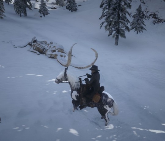
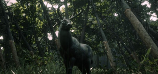
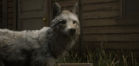
Some RDR2 Online stuff
Dunno, just wanted to share some stuff from online mode, since everything I found was 1+ years old (understandable considering how R* treats the RDRO base atm :/)
Anyway, here we go (with terrible pic quality)
Warning: graphic depiction of blood/violence between animals in the last very last picture.
Place 1: Meteor crate near Roanoke Valley. If you want to find it, just ride the west trail towards Brandywine Drop, and betwwen the trail and train rails it lies (look out for damaged trees without bark)

Place 2: Carving of a winged humanoid. Can be found near Bacchus Station when you follow a ledge (sometimes collector items spawn near too)

Place 3: Mammoth skeleton, up in Ambarino. Lies between Spider Gorge and Deadboot Creek.
And after finally reaching rang 5 with the naturalist, here are 3 of my favorite legendary animal intros so far (free translate, since I missed Harriets audio and play with german subs
1: Midnight buck (found near the meteor crate)
2: Milk coyote (found in Blackwater)
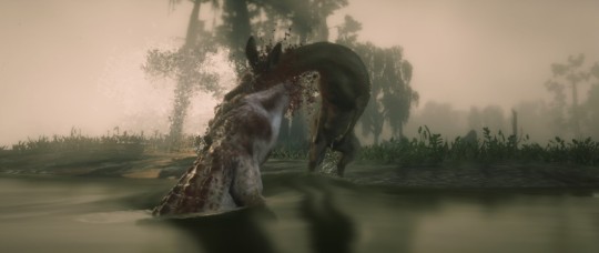
3: Striped alligator with an unfortunate doe (found in Bayou Nwa)
Probably making another one, or doing a character post next. We’ll see
#rdr2#rdr2 online#online mode#locations#gaming#nature#animals#legendary animals#naturalist#gaming content#oc
3 notes
·
View notes
Text
Exploring British Columbia
Our second week(ish) in Canada felt like a long one - having left Calgary, we did a lot of miles and saw a lot of different places in just a few days. The first day on the road involved a pretty epic drive, through the length of both Banff and Jasper National Parks. We took the more scenic Bow Valley Parkway through Banff NP, and were rewarded within a few minutes by a couple of raggedy-looking bighorn sheep crossing the road. Then, turning to our left, we saw something else quietly grazing by the side of the road - a large grizzly bear! It was amazing to see, but equally we were very glad that we were in the car and not walking.
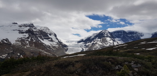
We then drove along the Icefields Parkway from Lake Louise to Jasper. The road climbs high into the mountains, with the jagged icy peaks all around making for incredible scenery. We stopped to walk the Wilcox Pass Trail which my trusty Footprint book assured us was not too long but with quick rewards. It was right - the path climbs steeply through forest that felt hushed and ancient, with the silvery skeletons of fallen trees all around us on the forest floor. As we got higher and the trees fewer, a few colourful wildflowers were beginning to peek through, although as we climbed higher still, patches of melting snow were still on the ground. The views for the whole trail were incredible, we could see the vast mountains in every direction and had clear views of the stunning Athabasca Glacier. We finished the walk where the vegetation stopped and the landscape became desolate, mountain rock.

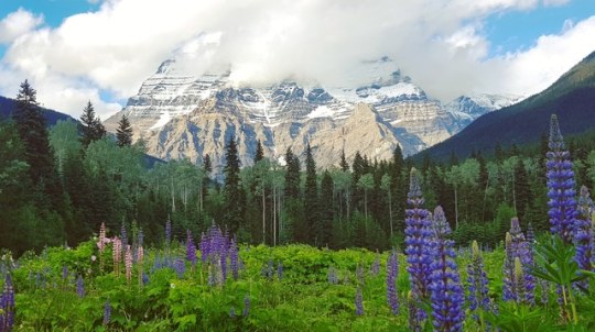
As we continued our journey (where we saw a couple more black bears), we stopped at Mount Robson - the highest peak in the Rockies. Clouds obscured its peak, but the blue skies around it and a lovely lupin meadow framed it beautifully. Our journey ended in Valemount, where we stayed in a lovely mountain cabin with great views and a hundred mosquitoes.
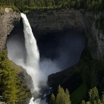
The next day we were on a waterfall mission (with bear spray in hand, obvs). We headed into Wells Gray Provincial Park towards Helmcken Falls, the 4th highest waterfall in Canada. This park was hilly rather than mountainous, with a wild and rugged feel, and the weather was much warmer. Amongst the verdant surroundings, the sides of the road were blue, purple and pink with lupins and dog roses. The falls themselves are stunning - the water plunging off a ledge has carved out an incredibly deep, wide hollow, thundering and swirling at the bottom and continuing its route through a gorge. The gorge is formed of red striped volcanic rock topped with lush green forest which reaches right to the teetering rim, which is undercut where the falls drop.

Also within the park we saw the powerful torrent at Dawson Falls and the pretty Moul Falls.
That evening, we stayed in a gorgeous Airbnb in Clearwater and went to a delicious barbeque restaurant, wishing that we were staying more than one night.
Our next destination was Revelstoke - located to the west of Banff, as we got closer the landscape became more mountainous again, although still very green. At the hotel, the receptionist looked at our address when we checked in and said, “Trowbridge, UK... I used to live there.” Small world indeed!! Revelstoke was relaxed with plenty of cafés and encircled by lovely scenery - again, another night here may have been nice.
After a night in Kamloops - which was just a stopping point - we continued west on the Sea to Sky Highway. The main highlight today was hiking the Joffre Lakes Trail. Unfortunately as we were here on a Saturday it was quite busy, with Instagram posers out in full force and jostling for the main viewpoints, but it was still a stunningly beautiful trail. The first of 3 lakes is reached within about 5 minutes, and the snowy mountain backdrop is reflected in its glassy waters.
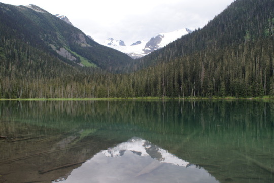
The path gained elevation very quickly through old growth forest - it was really steep with roots and often fallen trees across the path (I think Dom was cursing my choice of trail with each step). The layers of deep green forest as we climbed higher and looked back were breathtaking. We reached Middle Joffre Lake, which was much smaller but much more turquoise than the first one, and had amazing views of the mountains behind it.
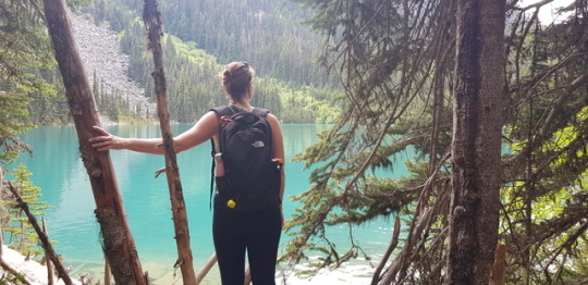
Silvery dead trees lay amongst the living forest, which was draped with moss - the forest here is very natural, with trees falling all the time and mostly being left where they lay to allow the surrounding trees to adapt. Finally, we reached Upper Joffre Lake, with amazing close up views of the mountains above the treeline, and a glacier perched high on the peak emitting that weird, glacial-blue glow even in cloudy weather.

After clambering back down, we spent the night in a cute town called Pemberton, which was packed with excellent food and beer thanks to its proximity to upmarket Whistler.
Before arriving in Vancouver and returning our hire car, we made one more waterfall stop at the gorgeous Brandywine Falls, a picture-perfect cascade with a rainbow glimmering in its mist.

This week’s count: Mosquitoes 10, Kirsty 0
2 notes
·
View notes
Text
Dogging' Philadelphia: 10 Cool Things to See When You Walk Your Dog
"If your dog is fat," the old saying goes, "you aren't getting enough exercise." But walking the dog need not be just about a little exercise. Here are 10 cool things you can see in greater Philadelphia while you hike with your dog.
FOLK ART
In 1855, a hotel entrepreneur built a new inn on Rex Avenue. To draw attention to his hostelry he constructed an Indian from old barn boards and propped it up on top of a rock overlooking the Gorge. In 1902, when the Indian Rock Hotel was long gone but with the silhouette still there, artist Massey Rhind was commissioned to make a representation of a "Delaware Indian, looking west to where his people have gone." The kneeling warrior has gazed up the Wissahickon Gorge ever since. A switchback trail leads to the Indian Statue where you can get close enough to pat his knee. And take in a breathtaking view.
MONUMENTAL M0NUMENTS
The Multi-Use Trail rolls past reconstructed huts and parade grounds that transport you back to the Revolution. The National Memorial Arch, a massive stone tribute dedicated in 1917, stands out along the route. The inscription reads: "Naked and starving as they are, we cannot enough admire the incomparable patience and fidelity of the soldiery. Washington at Valley Forge, February 16, 1778." In the southern part of White Clay, reached by the Twin Valley Trail, is the Arc Corner Monument marking one end of the 12-mile arc which forms the Pennsylvania-Delaware state line, unique in American political boundary-making. The circular divide dates to William Penn's directive of August 28, 1701, when Delaware was still a part of Pennsylvania, known as the Lower Three Counties. A little more than 1/2 mile to the west is another monument marking the tri-state junction of Delaware,Pennsylvania and Maryland.
AMERICAN CASTLES
Breaking out of the woods at several points on the hilltops you are greeted with an unparalleled view of Granogue, one of the more spectacular of the American castles dotting the Brandywine Valley's chateau lands.
MOVIE LOCATIONS
Flying concentric circles outward from Philadelphia, Hollywood location scouts for Oprah Winfrey's movie project, Beloved, spotted the Fair Hill terrain and selected it as the backdrop for the film's rural scenes. A ramshackle 19th-century tenant farm was constructed and much of the movie shot here. The producers decided to leave the movie set intact, to deteriorate naturally. You can wander among the fake buildings and even knock on the styrofoam stones.
COOL FORTS
Where else can a dog climb into an actual battery and scan the Delaware River where gunnery officers once aimed guns capable of accurately firing 1,000-pound projectiles eight miles like he can at Fort Mott State Park? Fort DuPont, named for Civil War fleet commander Admiral Samuel Francis duPont, saw active duty in three wars before becoming a state park. The 1-mile River View Trail, a grassy loop path, begins in the marshland along the Delaware River and finishes in shaded woodlands. The trail takes you past several ruins of the military installation, camoflauged to river traffic, and features sustained views of the Delaware River and Fort Delaware on Pea Patch Island.
REMARKABLE BRIDGES
In the farthest northern section of Tyler State Park is the longest covered bridge in Bucks County. The 117-year old Schofield Ford Covered Bridge burned in 1991 but after five years of fundraising the 166-foot, two-span crossing was entirely rebuilt by volunteers on its original stone abutments using authentic period materials and methods. An elaborate, reinforced wooden railroad trestle bridges a ravine on the Glen Trail. The trail runs by a stream under the trestle and there are sweeping views of Wenonah Woods from the top.
A walk through Brandywine Park provides a quick lesson is the history of bridge architecture. The classical arch form is represented in grand style with the magificent stone viaduct across the river and numerous reinforced concrete spans. There is even a small iron arch bridge over the mill race. A prototypical 19th century pier and girder iron bridge transports trains over the Brandywine. And the pedestrian footbridge across the water, the Swinging Bridge, is a little suspension bridge employing the same engineering principles as the mythical Brooklyn Bridge.
A floodplain is a safety valve for the release of a raging creek's overflow. Along the Paper Mill Trail, just off the Creek Road Trail, is an exhibit on managing these protective wetlands that create a unique wildlife habitat. The stone double-arch bridge next to the floodplain exhibit was built in 1847. The fall line on the Pennypack Creek was the natural choice for fording the creek back to Indian days. William Penn was not so patient in waiting for the tide to take the water away each day and in 1683 he asked that "an order be given for building a bridge over the Pennypack." Each male resident was taxed in either money or labor to build the bridge, which, when completed in 1697, became the first Three Arch Stone bridge in America. Designated a National Civil Engineering Landmark, the bridge over Frankford Avenue in Pennypack Park is the oldest stone bridge still carrying heavy traffic in America. Germantown Pike was the first road to be started in Montgomery County, dating to 1687 when funds were allocated for a "cart road" from Philadelphia to the Plymouth Meeting settlement. Later extended to present-day Collegeville, an eight arch stone bridge was built to span Skippack Creek in 1792. An equestrian trail crosses the bridge, which is the oldest bridge in continuous, heavy use in America. Ashland Covered Bridge, built in the days before the Civil War; the adjoining Succession and Flood Plain Trails visit meadow, marsh, pond and forest landscapes.
Theodore Burr built a bridge spanning the Hudson River at Waterford, New York in 1804. He added an arch segment to the multiple truss bridge popular at the time, attaining a longer span. Patented in 1817, the Burr Arch Truss became one of the most common in the construction of covered bridges. The Larkin's Bridge, a 65-foot long, 45-ton "Burr Arch" covered bridge erected in 1854 and rebuilt in 1881, was relocated to the northeast section of the park in 1972. Larkin's Covered Bridge is the only remaining legacy of Milford Mills.
In 1850 Albert Fink, a German railroad engineer,
designed and patented a bridge that used a latticework of rods instead of cables to reinforce stiffness. This construction was cheap and sturdy, making the Fink Truss one of the most commonly used railroad bridges in the 1860s, especially favored by the powerful Baltimore & Ohio Railroad, Only one Fink Truss bridge remains in the United States - an abandoned 108-foot span in Zoarsville, Ohio. A wooden reproduction of a Fink Truss is in a field at Warwick County Park for you and your dog to climb.
CANAL LOCK
Pennsylvania's first canal system was cobbled together in 1815 using 120 locks to stretch 108 miles from the coal fields of Schuylkill County to Philadelphia. Railroads began chewing away at canal business in the 1860s and the last coal barges floated down the Schuylkill River in the 1920s. Today, the only sections of the canal in existence are at Manayunk and Lock 60, built by area name donor Thomas Oakes, at the Schuylkill Canal Park. In 1985 the Schuylkill Canal Association formed to keep the canal flowing and maintain the lock and towpath. In 1988, the area was added to the National Register of Historic Places.
CHAMPION TREES
The Taylor Memorial Arboretum provides a 12-Tree Self-Guided Tour. The collection is especially strong in Far Eastern specimens and spotlights three Pennsylvania State Champion trees: the Needle Juniper, the Lacebark Elm and the Giant Dogwood. Also on the tour is a Dawn Redwood, an ancient tree known only through fossils until 1941 when a botany student tracked down living specimens in rural China. Some of the first seed to come to America resulted in this tree. Liberated from their sun-stealing neighbors of the crowded woods, the "King" and "Queen" White Oaks have spread out into a massive canopy of leaves. The "Queen" measures seventeen feet around at the thickest part of the trunk and the "King" is closer to twenty. The two trees are part of the "Penn's Woods" collection of 139 trees standing when William Penn arrived to survey his Pennsylvania colony.
The arboreal oldsters reside at the last stop of the nature trail. bacterial infection. Awbury Arboretum in East Germantown was the summer estate of 19th century Quaker shipping merchant Henry Cope. Across the 55 acres are plantings of groves and clusters of trees set amidst large swaths of grss fields in the English landscape garden tradition. You can investigate more than 200 species, mostly native, in your informal explorations of the grounds. Old macadam paths lead to most areas of the odd-shaped property. Also on the grounds are wetlands surrounding an artificial pond.
BARNS
While many of the Hospital Farm's buildings have disappeared, the unique dairy barn remains. Built in 1914, it is shaped like a wheel with four spokes. The fame of the hospital's dairy operation was widespread. In 1961 alone, nine cows produced 1.1 million pounds of milk - more than 300 pounds of milk per cow per day.The Visitor Center is a restoration of a 1923 Sears & Roebuck mail order barn. A century ago Sears sold anything and everything by mail - including kits for building houses and barns. The kit, which could cost as little as a few hundred dollars depending on style, would include rough lumber, framing timbers, plank flooring, shingles, hardware, sash and paint. Usually shipped by train from the west, the barn kit would be loaded onto a freight wagon and hauled to the building site for assembly by local carpenters.
COOL ROCKS
Forty million years ago an igneous explosion occurred underground here and cooled very quickly leaving behind a particularly fine granite rock. Tourists and students of geology alike made the pilgrimage to the Falls of French Creek to study the rock formations. Granite quarries mined the rock and granite from Saint Peters once received an award at the 1893 World's Columbian Exposition in Chicago as "a fine-grained polished cube, a good building and ornamental stone." The quarries closed in the 1960s and many pits can still be seen. Today the giant boulders in French Creek are ideal for your dog to sramble on - or just lie in the sun. Mountain in State Game Land #157. The mountain is essentially a ridge of diabase boulders and the trail to the top calls for almost continuous rock-hopping, a technique called bouldering. The basaltic rock provides incredible traction.
And our vote for the coolest thing of all on Philadelphia trails - the "Ringing Rocks" in Ringing Rocks Park where the rocks ping when struck by a hammer - or thud on "dead " spots.
Get the best boulder dog walkers

0 notes
Photo
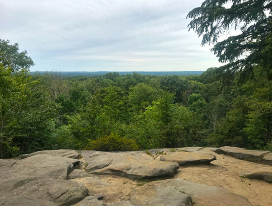
Best Things To Do in Cuyahoga Valley National Park
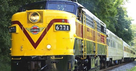
Best Things To Do in Cuyahoga Valley National Park: Though it's only a short distance from the urban areas of Cleveland and Akron, Cuyahoga Valley National Park seems worlds away. The park is a refuge for native plants and wildlife, and provides routes of discovery for visitors. The winding Cuyahoga River gives way to deep forests, rolling hills, and open farmlands. Walk or ride the Towpath Trail to follow the historic route of the Ohio & Erie Canal. You can fish, golf and even enjoy skiing and snowboarding! My name is Rob Decker and I'm a photographer and graphic artist with a single great passion for America's National Parks! I've been to 48 of our 61 National Parks — and Cuyahoga Valley is a great place to visit - regardless of the time of year! Cuyahoga Valley is unusual in that it is adjacent to two large urban areas and includes a dense road network, small towns, and private attractions. I have explored much of the park — so I'm ready to help! If this is your first time to the park, or your returning after many years, here are some of the best things to do in Cuyahoga Valley National Park! Ride the Scenic Train The National Park Scenic Railway is a unique way to experience all the natural wonder Cuyahoga Valley National Park. Sit back and relax as the train weaves through the Cuyahoga Valley and races along with the rushing Cuyahoga River. Look for eagles, deer, beavers and otters in their natural habitat. From January-May, the National Park Scenic excursion is a two-and-a-half hour round trip through Cuyahoga Valley National Park. Board at Rockside Station, Peninsula Depot, or at Akron Northside Station. From June through October, the train runs Wednesdays-Sundays on an extended schedule. You can choose from a variety of seating options including coach, table top, first class, lounge, upper dome, executive class, or suites. Hiking You can hike more than 125 miles of trails in Cuyahoga Valley National Park that range from nearly level to challenging. ,Pass through various habitats including woodlands, wetlands, and old fields. Some trails require you to cross streams with stepping stones or log bridges, while others, including the Ohio & Erie Canal Towpath Trail, are nearly level and are accessible to all visitors. A portion of Ohio's Buckeye Trail also passes through the park. Biking Biking the Towpath Trail This multi-purpose trail was developed by the National Park Service and is the major trail through Cuyahoga Valley National Park. Mountain Biking The East Rim Trail System has stunning views, varied terrain, exciting obstacles, and an element of adventure for anyone who explores it. Bike and Hike Aboard Bike or hike the Towpath Trail in one direction and hop on the train on your way back! The train can be flagged down at boarding stations by waving both arms over your head. You should arrive 10 minutes prior to the train's scheduled arrival...and you can pay your fare when you board. Visit the Beaver Marsh The Beaver Marsh is among the most diverse natural communities in Cuyahoga Valley National Park. The exceptional scenery and wildlife make it one of the park's most popular destinations. Here you can enjoy photography, bird watching, and sharing nature with family and friends. Enjoy Brandywine Falls Brandywine Falls is one of the most popular locations in the park. This 65-foot waterfall is accessed via a partially accessible boardwalk. For a more challenging trip, take the steep stairs to the lower viewpoint or the 1.4-mile Brandywine Gorge Trail. Hike or Picnic at The Ledges The Ritchie Ledges are witnesses to change - from creation out of Sharon Conglomerate millions of years ago, to landscapes wrecked by humans and to preservation today. The Civilian Conservation Corps created the park you see today, building trails and shelters throughout the area. Explore Blue Hen Falls This 15-foot waterfall is a beautiful hike every time of year. There is a small parking lot located across the street from the main trailhead. From there, the falls are a steep half-mile hike. Fishing The Cuyahoga River and numerous ponds are open to fishing. Cuyahoga Valley National Park's philosophy is to maintain the predator-prey relationship rather than to stock fish for recreational fishing. Catch-and-release fishing is encouraged to maintain the fish populations needed for continued sport fishing. The park has over 65 species of fish that live in its waters. Steelhead trout and bullhead can be caught in the Cuyahoga River. Bluegill, bass, and crappie can be caught in lakes and ponds in the park. Kayaking and Canoeing People who want to canoe or kayak the Cuyahoga River in Cuyahoga Valley National Park need to bring their own equipment and have experience to manage the safety risks posed by the river. The National Park Service does not maintain the river for recreational use. Canoeing and kayaking the river can be dangerous. Water quality, low head dams, and debris in the river all pose hazards. Horse Riding Viewing the Cuyahoga Valley landscape from horseback is like no other experience. Horseback riding is permitted only on trails signed and designated as horse trails. Horses need to be brought in as there are no horse rentals adjacent to the bridle trails. Try Your Hand at Canalway Questing Find more than 40 adventures—called quests—along the Ohio & Erie Canal! Put on your sleuthing hat and follow rhyming clues and a curious map to each hidden quest box. Along the way, discover the area's treasures—the natural and cultural gems of the Canalway. Unlike geocaching, no GPS unit is needed and no trinkets are exchanged. When you find a quest box, collect its unique stamp, sign its logbook, and put it back in place for others to discover. Golfing Cuyahoga Valley National Park offers the unique opportunity for golfing within the park, although none of the golf courses are federally owned or operated. You can golf at any of the following courses: Astorhurst Country Club Brandywine Golf Course Shawnee Hills Golf Course Sleepy Hollow Golf Course I've created a poster to celebrate Cuyahoga Valley National Park that features the famous Brandywine Falls. The poster can also be purchased at the Conservancy for Cuyahoga Valley National Park shops in the park! Click here to see the Cuyahoga Valley National Park poster. Rob Decker is a photographer and graphic artist with a single passion for our National Parks! Rob is on a journey to explore and photograph each of our national parks and to create WPA-style posters to celebrate the amazing landscapes, vibrant culture and rich history that embody America's Best Idea! Click here to learn more about Rob & the National Park Poster Project! https://national-park-posters.com/blogs/national-park-posters/best-things-to-do-in-cuyahoga-valley-national-park?utm_source=rss&utm_medium=Sendible&utm_campaign=RSS
0 notes
Photo


Cuyahoga Valley National Park
Only recently did I notice this large national park in Ohio, and I was excited that I would get to stop an explore it on my drive east. Cuyahoga Valley National Park has no shortage of hiking and biking trails throughout a historic landscape shaped by The Ohio and Erie Canal. My first stop was The Ledges Trail and Pine Grove where I explored a few easy miles of cliffs, crevices and caves along quiet forest trails. I then made a stop at the Boston Store, the park’s official visitor center, where I found some more maps and watched a shot park film. At lunchtime I drove over to Brandywine Falls and hiked the 1 mile loop around the gorge. Continuing north along Riverview Road and the canal, I eventually made one more stop in the Bedford Reservation to hike down to Bridal Veil Falls. It’s easy to knock out the main attractions of this park in one day, but there are enough additional trails and recreation areas to keep one busy for a long time. Overall, the park was quiet and easy to explore, but not something to get too excited about; especially having come from the mind-blowing national parks in the western part of the country.
Follow me on Instagram for daily photo updates @halcyontheroad
#Cuyahoga Valley#national parks#ohio#usa#america#forest#woods#nature#wilderness#hike#hiking#outdoors#explore#woodlands#scenic#waterfall#gorge#rock#cliffs#trail#roadtrip#travel#wanderlust#offgrid#nomad#van#vanlife#vandwelling#vandwellers#campervan
30 notes
·
View notes
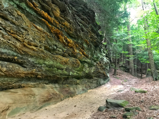
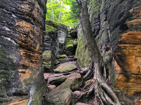
Photo

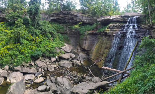
Brandywine Falls Trail // Cuyahoga Valley National Park // Ohio // USA
Brandywine Falls is a gorgeous hidden gem of Ohio, located in the only national park in the state, the Cuyahoga Valley National Park.
The beautiful sandstone and shales have been shaped over time by the water from the Brandywine Creek, creating a 65-foot layered cascading waterfall.
The 1.5 mile Brandywine Gorge Trail which leads to the falls boasts beautiful maples and hemlocks.
I highly recommend Cuyahoga in the fall.
Truly stunning.
#travel#travel photography#photography#cuyahoga valley national park#brandywine falls#travel blog#national parks#national park service
0 notes
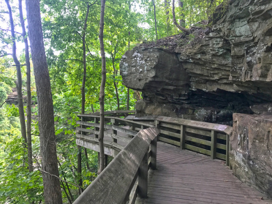
Photo
at Brandywine Falls gorge trail in CVNP https://www.instagram.com/p/ChLVuSqu6dmWLIgOv8hvVS_SnVmiuGQXNqy2kI0/?igshid=NGJjMDIxMWI=
0 notes
Photo

at Brandywine Falls gorge trail in CVNP https://www.instagram.com/p/ChLVdi6uFW87IEOEn8h0jIZ-M9YaPDuwavmqD80/?igshid=NGJjMDIxMWI=
0 notes
Photo

at Brandywine Falls gorge trail in CVNP https://www.instagram.com/p/ChLVdKcO6sL1OSh3KJ084VArjure8dV9_4_xtE0/?igshid=NGJjMDIxMWI=
0 notes
Video

flickr
Rapids and Waters of Brandywine Creek (Cuyahoga Valley National Park) by Mark Stevens
Via Flickr:
Here I used a variable ND filter but didn't bring it down all the way...just enough so that I could capture a slightly longer exposure and add some silkiness to the waters flowing by me. I worked with control points and color control points in Capture NX2 to bring out the contrast, saturation and brightness I wanted. I then added a Foliage and Sunshine CEP filter to give that little bit extra for the final image.
#Azimuth 120#Brandywine Creek#Brandywine Gorge Trail#Brandywine Gorge Trail Loop#CamRanger#Capture NX2 Edited#Cloudy#Color Efex Pro#Creek#Cuyahoga Valley National Park#Day 6#Image Capture with CamRanger#Landscape#Looking SE#Lower Peninsula-Heartland#Midwest-Great Lakes Area#Mostly Cloudy#Nature#Nikon D800E#North America Plains#Ohio-Wabash-Erie Area#Outside#Overcast#Project365#Tall Trees#Tall Trees All Around#Travel#Trees#Trip to Gateway Mammoth Cuyahoga National Parks#Ohio
1 note
·
View note
Video
I Have Lingered on the Shores to Watch the Waters of a River Float By (Cuyahoga Valley National Park) by Mark Stevens
Via Flickr:
A view over Brandywine Creek on the trail loop in Cuyahoga Valley National Park. What drew me into this setting was the water flowing downstream with the forest of greens and yellows all around. Given the overcast skies, it also seemed better to angle my Nikon SLR camera slightly downward to minimize any of those skies and allow for a more sweeping view with the creek.
#Azimuth 279#Brandywine Creek#Brandywine Gorge Trail#Brandywine Gorge Trail Loop#CamRanger#Capture NX2 Edited#Cloudy#Color Efex Pro#Creek#Cuyahoga Valley National Park#Day 6#Image Capture with CamRanger#Landscape#Looking West#Lower Peninsula-Heartland#Midwest-Great Lakes Area#Mostly Cloudy#Nature#Nikon D800E#North America Plains#Ohio-Wabash-Erie Area#Outside#Overcast#Portfolio#Project365#Tall Trees#Tall Trees All Around#Travel#Trees#Trip to Gateway Mammoth Cuyahoga National Parks
2 notes
·
View notes
Video
flickr
Rapids and Waters of Brandywine Creek (Cuyahoga Valley National Park) by Mark Stevens
Via Flickr:
Here I used a variable ND filter but didn't bring it down all the way...just enough so that I could capture a slightly longer exposure and add some silkiness to the waters flowing by me. I worked with control points and color control points in Capture NX2 to bring out the contrast, saturation and brightness I wanted. I then added a Foliage and Sunshine CEP filter to give that little bit extra for the final image.
#Azimuth 120#Brandywine Creek#Brandywine Gorge Trail#Brandywine Gorge Trail Loop#CamRanger#Capture NX2 Edited#Cloudy#Color Efex Pro#Creek#Cuyahoga Valley National Park#Day 6#Image Capture with CamRanger#Landscape#Looking SE#Lower Peninsula-Heartland#Midwest-Great Lakes Area#Mostly Cloudy#Nature#Nikon D800E#North America Plains#Ohio-Wabash-Erie Area#Outside#Overcast#Project365#Tall Trees#Tall Trees All Around#Travel#Trees#Trip to Gateway Mammoth Cuyahoga National Parks#Ohio
2 notes
·
View notes
Video
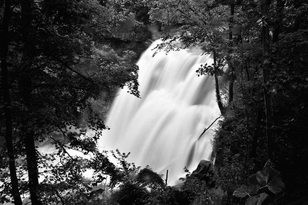
flickr
I Found So Many Pleasures to Give Life in the Forest and Woods (Black & White, Cuyahoga Valley National Park) by Mark Stevens
Via Flickr:
A conversion to black & white using Capture NX2 where I used some color filters to bring out a much richer tonal contrast for the final image. Captured at Brandywine Falls in Cuyahoga Valley National Park.
#65'#Azimuth 85#Bedford Shale#Berea Sandstone#Black & White#Brandywine Creek#Brandywine Falls#Brandywine Gorge Trail#Brandywine Gorge Trail Loop#CamRanger#Capture NX2 Edited#Cleveland Shale#Cloudy#Color Efex Pro#Creek#Cuyahoga Valley National Park#Day 6#Image Capture with CamRanger#Landscape#Long Exposure#Looking ENE#Looking through Trees#Lower Peninsula-Heartland#Midwest-Great Lakes Area#Mostly Cloudy#Nature#Nikon D800E#North America Plains#Ohio-Wabash-Erie Area#Outside
1 note
·
View note
Video

flickr
Across the Waters of Brandywine Falls and the Nearby Landscape (Cuyahoga Valley National Park) by Mark Stevens
#65'#Aurora HDR#Aurora HDR Pro#Azimuth 117#Bedford Shale#Berea Sandstone#Brandywine Creek#Brandywine Falls#Brandywine Gorge Trail#Brandywine Gorge Trail Loop#CamRanger#Capture NX2 Edited#Cleveland Shale#Cloudy#Color Efex Pro#Creek#Cuyahoga Valley National Park#Day 6#Exposed Rock#HDR#Image Capture with CamRanger#Landscape#Layers of Rock#Looking East#Lower Peninsula-Heartland#Midwest-Great Lakes Area#Mostly Cloudy#Nature#Nikon D800E#North America Plains
0 notes
Last Seen Blogs