#Cascade Volcanic Arc
Text


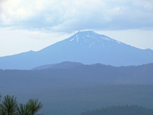
Clouds (No. 1230)
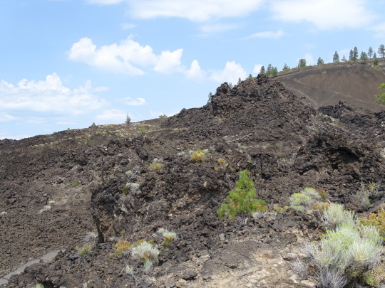
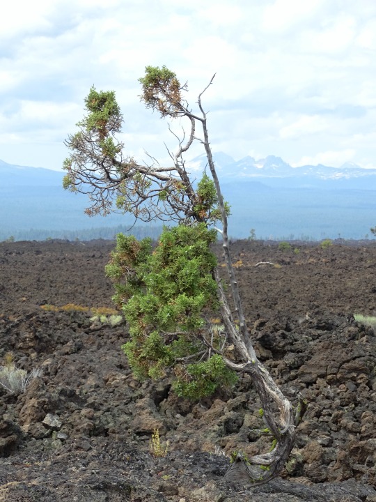
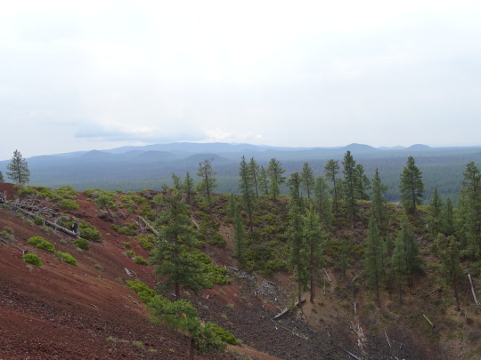
Newberry National Volcanic Monument
#Newberry National Volcanic Monument#Cascade Volcanic Arc#Deschutes County#travel#original photography#vacation#tourist attraction#landmark#USA#summer 2023#Oregon#Pacific Northwest#lava flow#fir#nature#landscape#countryside#Cascade Range#clouds#flora#grass#shrub#tree#Mount Bachelor#geology#Trail of Molten Lands
12 notes
·
View notes
Text

When I went around Glacier Peak, I was lucky to see 50 feet in front of me. I've always felt that was a stretch of the PCT that I should do again to, perhaps, see what I missed. The images from David Xiao's website pull me back . . . WOW! I missed so much.

It truly deserves a second chance.
Despite being 10,541' it is amazing just how much Glacier Peak is overlooked. In the 700-mile Cascade Volcanic Arc that extends from Lassen Peak on the south end to mountains north of the Fraser River in British Columbia, Glacier Peak is the most isolated of the 20 major volcanoes in the Arc.
6 notes
·
View notes
Video
flickr
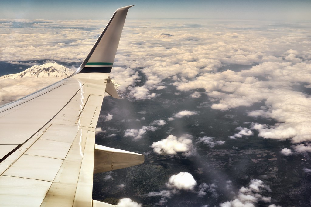
Stratovolcanoes off the Starboard Wing by Mark Stevens
Via Flickr:
A view looking to Mount Adams and then Mount St Helens while on an Alaska Airlines flight out of Seattle to Austin. The view of the mountain peaks were amazing just of themselves, but it was the entire setting with the plane wing, white puffy clouds and the mountain peaks popping up from the ground below that I wanted to capture.
#Airplane#Airplane Window#Airplane Window View#Airplane Wing#Alaska Airlines#Azimuth 247#Blue Skies#Blues Skies with Clouds#Cascade Range#Cascade Volcanic Arc#Day 10#Flight SEA to AUS#Flight to Austin#Flying Above Clouds#Flying Above the Clouds#In Flight#Inflight to Austin#Jet Airplane#Looking Outside Plane Window#Looking SW#Looking out Airplane Window#Looking out the Airplane Window#Miscellaneous#Mount Adams#Mount Adams Area#Mount Saint Helens#Mount Saint Helens Area#Mountain Peak#Mountains#Mountains in Distance
1 note
·
View note
Text

flickr


flickr
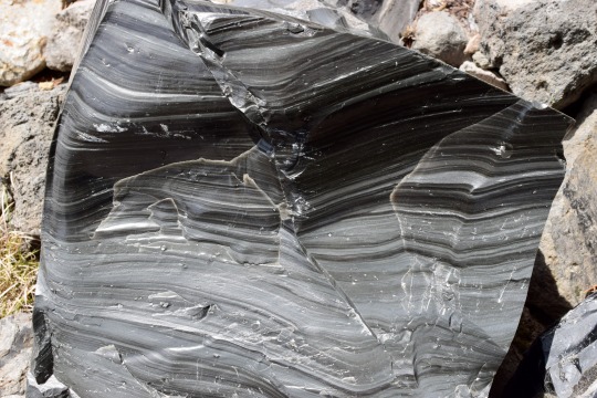
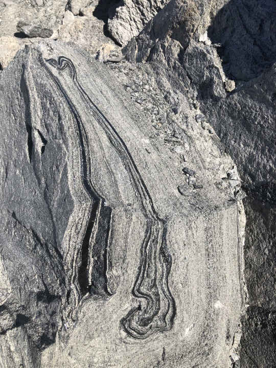
The Big Obsidian Flow is the youngest lava flow in Oregon, at the juvenescent age of ~1,300 years before present. It's a product of the most recent eruption of Newberry Volcano, the largest in the Cascade Range north of the California border (Medicine Lake Volcano is the largest overall). Newberry is a bit enigmatic - it's a huge volcano with a high rate of large eruptions but is not on the main Cascade volcanic arc. There's a number of converging fault zones in this area, which probably create significant crustal weakness allowing magma to percolate through the crust quickly.
Obsidian is common in lava flows of the rhyolitic composition, which is the most evolved kind of magma. Rhyolite magma spends lots of time spent in the crust for crustal rocks to contaminate the magma body and for heavier iron/magnesium-rich minerals to settle out, leaving behind a melt with over 68% silica (quartz). Silica is the same stuff regular glass is made of, so the higher your silica content then the glassier your lava flow is likely to be on the surface. The bands present in big chunks of obsidian are the result of shearing, differential cooling/composition, and flowing during the lava flow. This is very thick, sticky, viscous lava that doesn't like to flow. As it cools, it breaks rather than bends and turns the lava flow into a moonscape of glass shards and boulders.
The large amount of obsidian at this and other flows around Newberry Volcano is interesting because the volcano is mostly made of basalt - a lava with a near-opposite composition from rhyolite. Akin to Mauna Loa or Iceland, most of Newberry's lava flows form a broad shield more than 60 miles N-S and 30 miles E-W (roughly 100x50 km). The central part of the Volcano is about ten miles (16 km) across and contains a caldera formed when the central summit collapsed ~75,000 years ago. The caldera has been filled by subsequent eruptions and by two lakes separated by a big pumice cone. This means that the volcano produces - simultaneously - a wide range of magma compositions, indicating a complicated and long-lived magmatic system. Hazards from Newberry (to the 200,000 people living on its slopes) are not limited to fluid basalt eruptions that slowly blanket the landscape but also major explosive eruptions. The Big Obsidian Flow is a representative of the latter. Ash and debris from that eruption is found as far away as Idaho, and is many meters deep near the eruption's vent.
#oregon geology#geology#lava#magma#obsidian#volcano#volcanology#newberry volcano#central oregon#bendoregon#Cascade Volcanoes#PNW Volcano#rocks#oregon
159 notes
·
View notes
Text

Mount Baker peeks through the clouds - 10,781 ft active glacier-covered volcano in the Cascade Volcanic Arc and the North Cascades. @natgeotravel
#original photography#cannon camera#photographer on tumblr#nature#landscape#pws photos worth seeing#clouds#mountain#trees#mount baker#blue sky#washington state#volcano#north cascades
48 notes
·
View notes
Text

Mount Rainier Shadow
Mount Rainier in Washinton state is 4,392 meters tall, the tallest volcano in the Cascade Volcanic Arc. During a recent sunrise, the volcano cast its shadow on the rather low altitude cloud deck over Puyallup, Washington. Photograper Lisa Bishop captured the moment in this gorgeous image.
Credit: Lisa Bishop
70 notes
·
View notes
Text
The Cascade Range in western North America are a remarkably quiet volcanic chain. Even though potentially active volcanoes stretch from Lassen Peak in the south to Garibaldi in the north, the only volcano to erupt in the past century is Mount St. Helens (twice). That's it. Compare that to places like Japan, Kamchatka, Indonesia and other volcanic arcs where it isn't uncommon for multiple volcanoes to be popping off simultaneously, the Cascades feel downright silent.
This is why the volcanological community get excited when something, anything, happens. The something that has everyone's attention right now is the return of the "bulge" on the west side of South Sister, part of the Three Sisters volcanoes west of Bend in Oregon.
Now, all this doesn't mean the USGS Cascades Volcano Observatory thinks anything will happen soon ... or at all. They have not changed the alert status from "Green", the lowest level. Even if this is magma moving, we have little clue to whether it is enough to cause an eruption ... or if any eruption could happen in the next few years or next few centuries.
3 notes
·
View notes
Text
Ici Mi ! J'vous ai manqué ? Non ? Tant pis, aujourd'hui c'est quand même moi que vous aurez ! Mouahahaha ! ...Ahem. Bref.
Vous nous avez quitté au retour du Volcan, donc, et pour la journée suivante, nous avons décidé de rester (en partie) dans le thème, comme vous le verrez plus tard.
En effet, nous sommes partis en périple dans le Sud Sauvage, avec au programme plusieurs arrêts, que vous pouvez situer ici :

Au départ du Tampon, donc, nous nous sommes tout d'abord rendu au village de Manapany, avec deux buts : d'abord, profiter de la promenade en bord de mer...


Tiens, une Mi qui regarde le lointain !
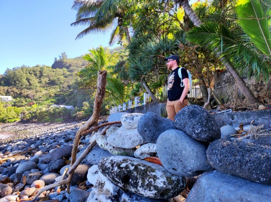
Et un Julien qui fait de même, à l'abri dans son fort ! (Oui, quelqu'un passé ici avant nous avait carrément construit un petit mur de galets en arc de cercle, tourné vers l'océan !)
... Et puis - surtout - trouver des lézards vert de Manapany ! Il s'agit d'une espèce de gecko endémique, non seulement à la Réunion, mais à Manapany spécifiquement - autrement dit, on ne le trouve que dans ce village uniquement ! Et accessoirement, il est absolument adorable... Voyez plutôt :
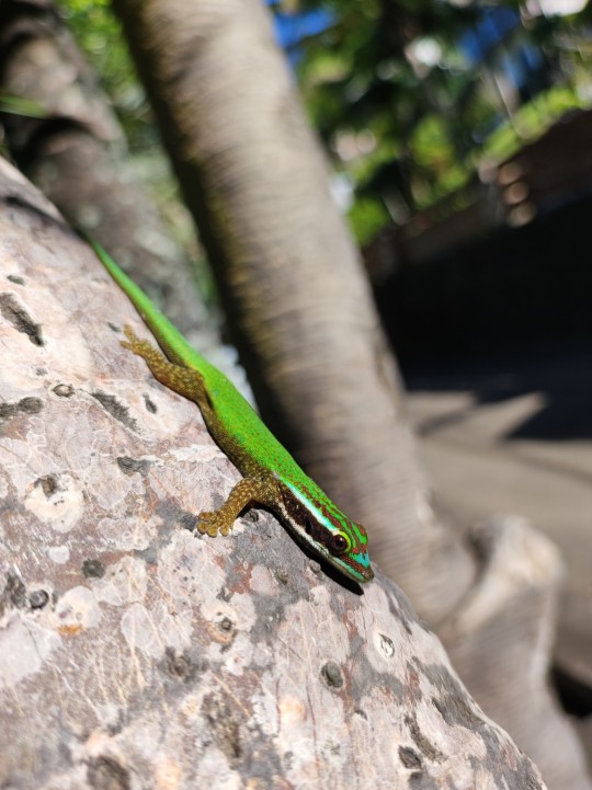
Non mais regardez-moi ce beau gosse. On a eu du mal à résister à l'envie d'en adopter deux ou trois.
On en a vu un bon nombre, répartis sur les arbres du front de mer, en train de prendre le soleil matinal ! 🦎❤️

Ça va, on est beaux gosses, nous aussi ?
Une fois avoir suffisamment couru après les lézards (plutôt timides devant l'appareil photo, il faut bien l'admettre), nous repartons, et commençons à remonter la route qui longe la rivière Langevin... Le paysage est évidement magnifique : d'un côté, la rivière proprement dite avec son eau claire, et de l'autre, la végétation luxuriante, et le versant de la ravine dont l'ombre grandit à mesure que nous approchons de notre point de chute : la superbe cascade Langevin !

Nous profitons de la vue (et de la fraîcheur de la cascade qui nous éclabousse), et Julien en profite pour laisser le stress de la route retomber un peu : pour arriver jusqu'ici (pas mal plus haut que notre première étape, donc), la route serpente au fond de la ravine, avec des virages en épingles sur une pente à 22% ! Autant dire que c'était assez éprouvant pour les nerfs. Mais le spectacle valait le coup !
Après être redescendu par là où nous étions arrivés (un peu moins stressant, mais nous étions quand même contents d'arriver enfin en bas !) nous avons repris la route, direction... La pause repas ! Nous jetons notre dévolu sur un tout petit restaurant nommé Le Macabit, tout près de Saint-Philippe, où nous nous régalons : au menu, carri dorade pour moi, et rougail saucisses pour Julien, accompagné de lentilles... Et du chant des coqs dans la cour attenante !
Et puis, vient enfin l'étape que Julien vous a teasé hier : le Grand Brûlé ! Et vous savez quoi ? Moi aussi je vais vous laisser sur votre faim, et vous donner rendez-vous dans un second post pour cette partie-là ! 😇 (Mais ne vous inquiétez pas, il arrive juste après celui-ci !) En attendant, voici un avant-goût :

Qui sont donc ces mystérieuses silhouettes ? (Plot twist : c'est nous.)
Après cet arrêt (en plusieurs temps, comme vous le verrez plus tard), nous amorçons la route du retour, avec tout de même une dernière étape : l'Anse des Cascade, dans la commune de Piton Sainte-Rose. Il s'agit d'une baie entourée de falaises d'où jaillissent de multiples cascades (comme son nom l'indique, me direz-vous). Le cadre est assez magique, avec ses minuscules cours d'eau qui serpentent au pied des falaises, se croisent, se transforment parfois en petites étendues presque marécageuses, et se rejoignent enfin pour se jeter dans la baie.
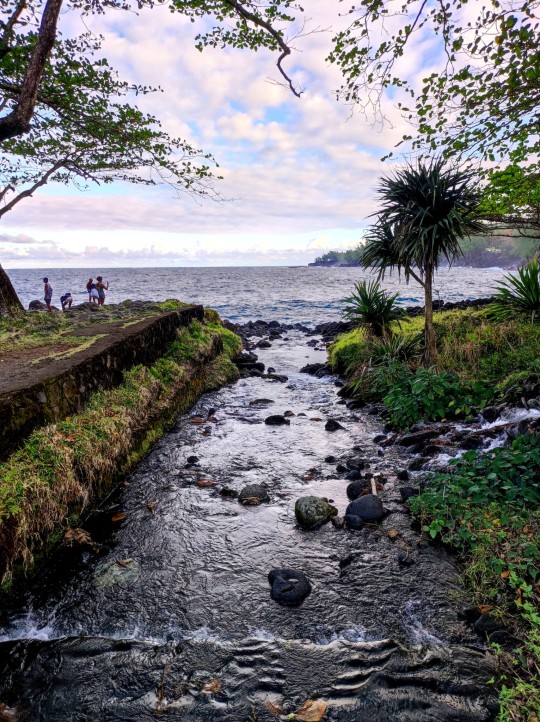
Julien, absorbé par la contemplation des cascades...
Nous avons ensuite pris le chemin du retour, mais c'est une autre histoire !
7 notes
·
View notes
Link
6 notes
·
View notes
Photo
“This short interpretive trail starting at the Lava Lands Visitor Center in the Newberry National Volcanic Monument will give you an informative glimpse into the geology of the Cascades and much of the Pacific Northwest. The trail takes you on a short, one-mile tour of one of the largest currently-exposed lava fields of the Cascade Volcanic Arc… it lays today, stretching 5 miles to the north, 3 miles to the west, and covering an area of over 6,000 acres. The lava flow completely moved the Deschutes River off of its original track.” #deschutesnationalforest #newberryvolcanicnationalmonument #volcano #bendoregon #oregon #pnw #naturephotography #nature #hike (at Trail of the Molten Land) https://www.instagram.com/p/Ckg9pMoO1Nt/?igshid=NGJjMDIxMWI=
#deschutesnationalforest#newberryvolcanicnationalmonument#volcano#bendoregon#oregon#pnw#naturephotography#nature#hike
2 notes
·
View notes
Text


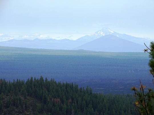


Clouds (No. 1223)
Newberry National Volcanic Monument
#Newberry National Volcanic Monument#Cascade Volcanic Arc#Deschutes County#travel#original photography#vacation#tourist attraction#landmark#USA#summer 2023#Oregon#Pacific Northwest#lava flow#fir#nature#landscape#countryside#Cascade Range#clouds#Mount Bachelor#Broken Top
14 notes
·
View notes
Text
Mount Shasta—Reality or Hoax? has been published on Elaine Webster - http://elainewebster.com/mount-shasta-reality-or-hoax/
New Post has been published on http://elainewebster.com/mount-shasta-reality-or-hoax/
Mount Shasta—Reality or Hoax?
Mount Shasta—Reality or Hoax?
(Shared from ‘Mu the Motherland‘)
Mount Shasta is a dormant volcano rising 14,179 feet in the Cascade Range of Northern California. The mountain is composed of four major volcanic cones built of layers or strata—each one created in its own eruptive period and overlapping with the others. There is a fifth cone, the Red Fir Cone, which outcrops lower on the mountain at 6340 feet and is often referred to as ‘Ancestral Mt. Shasta’ with rocks dated back about 590,000 years. (Most of what can be seen is less than 200,000 years old.) In comparison, the Shastina cone is only about 9700 years old and the last eruption was about 200 years ago from the Hotlum cone.
Image Source: College of the Siskiyous Library
The Cascade Range is part of “The Ring of Fire”, a chain of volcanic arc and trenches that border tectonic plates, so it’s no wonder that those that are sensitive to earth energies feel an intensity in this area. It is also not unusual for Native Americans to gravitate towards these energies. In fact, Shasta is a modernized spelling of “Sastise” the name used by Klamath Indians to describe an enemy tribe on the other side of the mountain; suggesting that they regarded the peak both as protection and a power source. The mountain was first summited in 1854 by Elias Davisson Pierce and party. Author Joaquin Miller spent four years in the area and John Muir survived an overnight snowstorm on the summit in 1875. Did any of these people, see or hear anything unusual? If they did, they didn’t report on it. However, advance to 1987 and Shasta was labeled a power point site for the Harmonic Convergence—the first synchronized peace meditation. Many consider the mountain to be one of the Seven Sacred Mountains of the World and Native Americans consider the area to be a place of balance between earth and the universe.
So, where did all the speculation begin about mystic temples hidden within the mountain and the advanced Lemurian civilization that is believed to live there? Well, it started with a teenager—a resident of Yreka—Frederick Spenser Oliver and his book ‘A Dweller on Two Planets’. Oliver wrote about mystical beings, sacred brotherhoods, temples, mysterious lights, and spaceships, but he insisted that he was not the author, but was channeled by ‘Phylos the Thibetan’. Oliver died at the young age of 33 and the book was published posthumously in 1905 by his mother and a group of friends.
Then, the ball seems to have been picked up again in 1931 when Wishar Spenle Cerve (pseudonym of Harvey Spencer Lewis) wrote and published through the Rosicrucian Order, ‘Lemuria, The Lost Continent of the Pacific: The Mystery People of Mount Shasta’. Cerve wrote that Lemurians were tall, graceful, and agile, with larger heads and much larger foreheads than average humans. If you peruse the local bookshops you will come across many accounts of Lemurians coming into town for supplies, often paying with gold nuggets. It was these stories that spurred the metaphysical tourism that is still prevalent today.
In 1934 author Guy Warren Ballard (pen name Godfre Ray King) wrote a memoir, ‘Unveiled Mysteries’, describing his meeting with “Saint Germain” on Mount Shasta. Yes, this is the same Saint Germain who worked at the Court of France during the French Revolution. His wife, Edna (after her husband’s death in 1940) continued to publish information about these encounters for the “I AM” movement and the group she formed continues to visit Mount Shasta.
There is so much written, filmed, and presented about Mount Shasta—the list of information is endless and easily accessed on-line. However, the one account that struck me as valid and unexplainable is the widely reported incident of a 3-year-old boy. In September 2011, a 3-year-old-boy and his dog wandered off from Fowler’s Campground at McCloud Falls, which is down the hill from Shasta sparking a desperate search of the area. The dog was found, wet and cold, but alive near some rapids. The search continued on the assumption the toddler might have been swept away in the rapids. Local news covered the search and the boy was found. However, his rescue came with an interesting story of being captured by a robot and taken to a creepy place. He described a cave and a woman, a grandmother, who told him he was from outer space and he was placed in his mother’s womb. This same woman took the boy back to the river and told him to wait for the searchers, which he did and was found. Most people dismiss the story as an over-active imagination of a small boy. However, it’s interesting that the dog was found first, alone, and the boy appeared later. Hmmm.
Finally, Pluto’s Cave, north of the mountain was prehistorically occupied by Native Americans and after the gold rush, secret societies conducted initiations and rituals there. Today many believe that it is a portal into Inner Earth and an underground secret city. The cave is managed by Klamath National Forest and is a lava tube that can be hiked into for approximated 1200 feet. The cave itself is larger than those found in the Hawaiian Islands. There are multiple lava flows visible in the cave walls. Most expert on the supernatural nature of Shasta and these tubes is author, Dustin Naef, who says that numerous hikers have reported seeing people literally walk into the rocks walls and disappear, presumably to enter the Hollow Earth and possibly the secret city of “Telos”.
Critics and skeptics argue that the Lemurian legend and the idea of an underground city beneath Mount Shasta are nothing more than imaginative folklore and unsubstantiated claims. They point out the lack of concrete evidence and scientific support for these beliefs. Skeptics argue that the stories surrounding the Lemurians and the Subterranean City of Mount Shasta are primarily based on subjective experiences, personal anecdotes, and channeled information, which are difficult to verify or validate.
Despite the lack of empirical evidence, the allure of the Lemurian legend and the Subterranean City of Mount Shasta persists. For believers, the stories offer a sense of wonder, hope, and spiritual inspiration. They find solace in the idea that there may be a hidden realm of enlightenment and higher consciousness accessible to those who seek it. The myth of the Lemurians and Mount Shasta also serves as a metaphorical representation of humanity’s longing for a more harmonious and spiritually connected existence. One thing that is undeniable is that Mount Shasta exudes power—physical and spiritual power. How each of us use nature’s power is an individual preference, but it will not and cannot be denied.
Additional Reference Source:
College of the Siskiyous Library
Mount Shasta Fact Sheet
0 notes
Text
The Cascade Volcanic Arc at its best:
Mt. Jefferson, Mt. Hood, Mt. Adams, Mt. St. Helens and Mt. Rainier all in one picture taken from a plane.
Credit: Tawnie Justine Vrooman
1 note
·
View note
Text
Overview of Willamette Valley Wine Tours and Mount St. Helens Guided Tours
Mid-Willamette valley vineyards have developed a reputation for producing some of the best Pinot Noir grapes in the world and excellent Pinot Gris. The Willamette Valley American Viticultural Area is the largest AVA in the state, encompassing 5,200 square miles, and is home to most of the state s wineries. The Willamette Valley AVA is divided into six sub-regions, each of which has its particular soils, climates and elevation. The area is also noted for its vast diversity of wines, each having its own defined character despite their vineyards being only a short distance apart. One can find a number of amazing things during the Willamette valley wine tours.
The Chehalem Mountains AVA was founded in 2006 and covered 70,000 acres stretching from Wilsonville to Forest Grove, of which more than 1,600 acres are given over to vineyards. There are more than 100 vineyards in the Chehalem Mountains AVA and 31 wineries. The AVA also has the three central hillside soil types ideal for grape cultivation: ocean sedimentary, basaltic and blown lake bed sediment.
The Eola-Amity Hills AVA covers an area some 15 miles long by 6 miles wide and stretches from Amity in the north to the capital Salem in the south. Grape production in the region benefits from the Pacific Ocean's steady winds that reach the Valley through the Van Duzer Corridor. Some 1,300 acres of the almost 40,000-acre AVA are given over to vineyards. The soils are mainly composed of volcanic basalt produced by ancient lava flows as well as marine sedimentary rocks and alluvial deposits.
Mount St. Helens guided tours
Mount Saint Helens is probably one of the most famous volcanoes in the United States, along with Hawaii's Mauna Loa, which is itself the most massive volcano on the earth. Mount St. Helens is still active, after its last fierce eruption in 1980. It is a stratovolcano located in Skamania County, Washington. It is located in the Cascade Mountain Range, and is known as a part of the Cascade Volcanic Arc. This is a small segment of the pacific Ring of Fire that includes over 160 active volcanoes. Mount St. Helens guided tours will let you explore the amazing features and the magical natural phenomena.
1 note
·
View note
Text

Mount Hood, Oregon
Mount Hood is a potentially active stratovolcano in the Cascade Volcanic Arc. It was formed by a subduction zone on the Pacific coast and rests in the Pacific Northwest region of the United States. It is located about 50 mi (80 km) east-southeast of Portland, on the border between Clackamas and Hood River counties. In addition to being Oregon's highest mountain, it is one of the loftiest mountains in the nation based on its prominence, and it offers the only year-round lift-served skiing in North America.
📷 @ Jesse.Brackenbury
80 notes
·
View notes
Video
flickr
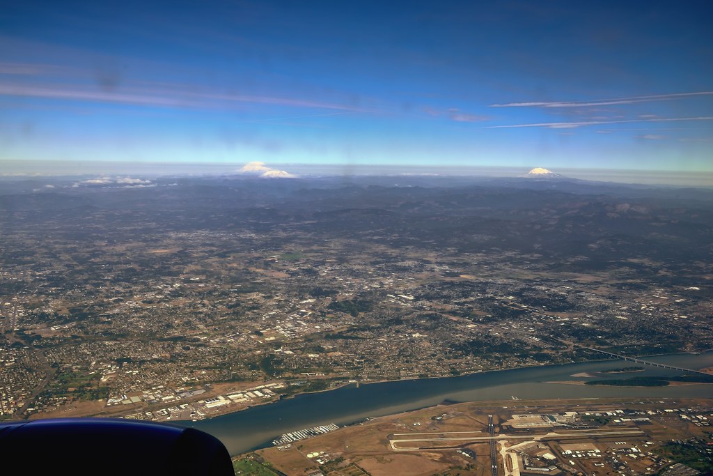
The Columbia River, an Airport and a Few Stratovolcanoes by Mark Stevens
Via Flickr:
A wide angle view after making a turn during a flight out of Portland. With the runway in the immediate foreground, I wanted to capture a sweeping view as one looked up to see Mount Rainier, St. Helens and Adams along with the Washington countryside.
#Cascade Range#Cascade Volcanic Arc#Color Efex Pro#Columbia River#Curve of Earth#Day 6#Flight PDX to DIA#Inflight#Looking out Window#Mount Adams#Mount Rainier#Mount St. Helens#Mountains#Nature#Nikon D800#PDX Airport#Portland OR#Project365#Runways#Snowcapped#Stratovolcano#Vancouver#Washington#United States
7 notes
·
View notes
Last Seen Blogs


mxnsxngie
8 Is Fate

sumiire-creates
sumiire ♡

the-dream-pawners-canvas
The Dream Pawner

rakundoodles
Rakun