#Navajo Volcanic Field
Video
flickr
Shiprock and a Look Across the New Mexico High Desert by Mark Stevens
Via Flickr:
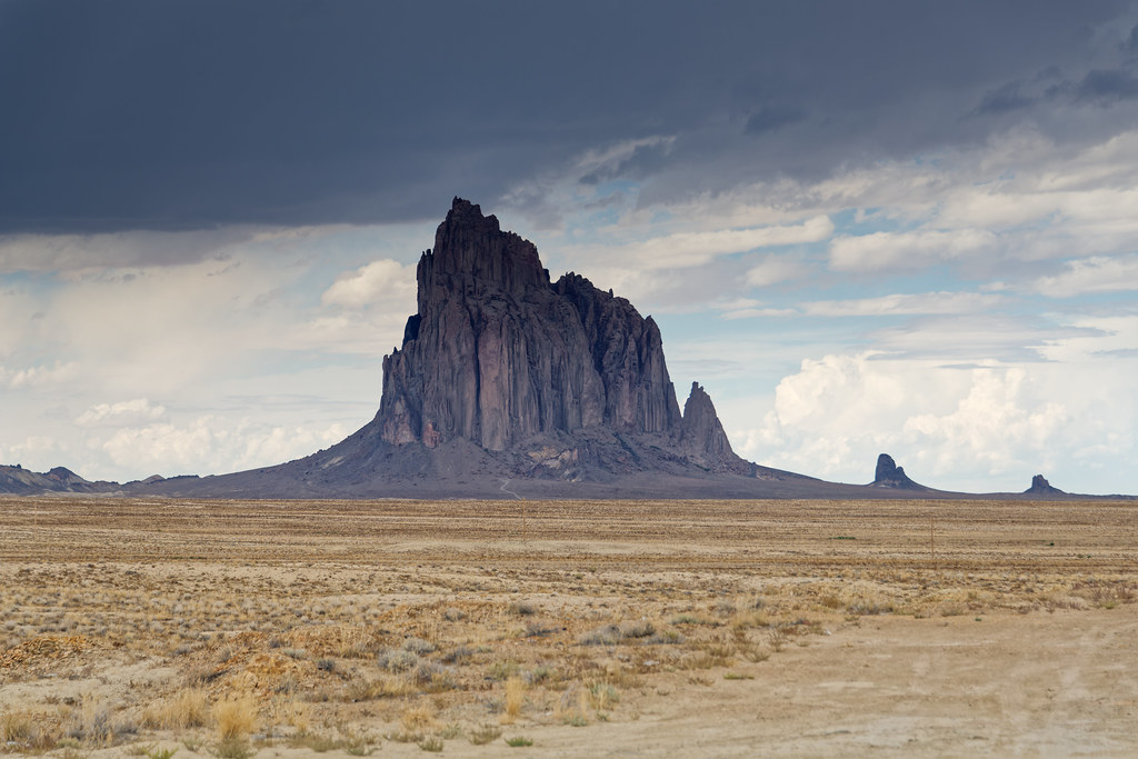
A setting looking to the northwest while taking in views across the northern New Mexico high desert with a distant view to the Shiprock formation. This is at a roadside pullout along Indian Service Rte 13. With this image, I pulled back on the focal length to include more of the surrounding landscape to add to the setting in the image captured.
#Azimuth 320#Blue Skies#Blue Skies with Clouds#Chuska Mountains#Colorado Plateau#Day 3#Desert Landscape#Desert Mountain Landscape#Desert Plant Lifes#Diatreme#DxO PhotoLab 7 Edited#Erosional Landscape#High Desert#Igneous Rock#Indian Service Rte 13#Intermountain West#Landscape#Landscape - Scenery#Looking NW#Monadnock#Mostly Cloudy#Nature#Navajo Area#Navajo Volcanic Field#New Mexico and Mesa Verde National Park#Nikon D850#No People#Outside#Partly Cloudy#Partly Sunny
4 notes
·
View notes
Text


Kayenta, AZ (No. 3)
Agathla Peak or Agathlan (Navajo: Aghaałą́, Spanish: El Capitan) is a peak south of Monument Valley, Arizona, which rises over 1,500 feet (460 meters) above the surrounding terrain. It is 7 miles (11 km) north of Kayenta and is visible from U.S. Route 163. The English designation Agathla is derived from the Navajo name aghaałą́ meaning 'much wool', apparently for the fur of antelope and deer accumulating on the rock. The mountain is considered sacred by the Navajo.
Agathla Peak is an eroded volcanic plug consisting of volcanic breccia cut by dikes of an unusual igneous rock called minette. It is one of many such volcanic diatremes that are found in Navajo country of northeast Arizona and northwest New Mexico. Agathla Peak and Shiprock in New Mexico are the most prominent. These rocks are part of the Navajo Volcanic Field, in the southern Colorado Plateau. Ages of these minettes and associated more unusual igneous rocks cluster near 25 million years.
Source: Wikipedia
#Agathla Peak#Kayenta#Navajo County#Navajo Nation#evening light#travel#original photography#vacation#tourist attraction#landmark#architecture#cityscape#landscape#countryside#sky#clouds#USA#desert#Southwestern USA#small town#Arizona#summer 2022#evening sky#geology#nature#flora
1 note
·
View note
Video
Agathla Peak by James Marvin Phelps
Via Flickr:
Agathla Peak Navajo County Arizona October 2021
#Arizona#Agathla Peak#Navajo Nation#Navajo County#Monument Valley#Kayenta#Volcanic Plug#Minette#Colorado Plateau#Landscape#Navajo Volcanic Field#James Marvin Phelps Photography
4 notes
·
View notes
Photo

Orion rising over a volcanic plug in the Navajo Volcanic Field as seen with an 85mm lens and very sensitive camera [OC][2047x3072] IG:@dheeranet
📷: dheera
15 notes
·
View notes
Text


1999: Pre-digital images of Shiprock and other necks in the Navajo Volcanic Field. Who knows when I can get back there, with a drone and nice camera gear?
44 notes
·
View notes
Text

Orion rising over a volcanic plug in the Navajo Volcanic Field as seen with an 85mm lens and very sensitive camera
- IG:@dheeranet
- Author: dheera on reddit
9 notes
·
View notes
Photo

Orion rising over a volcanic plug in the Navajo Volcanic Field as seen with an 85mm lens and very sensitive camera [OC][2047x3072] IG:@dheeranet source:https://ift.tt/fw3uM7T
3 notes
·
View notes
Photo

Orion rising over a volcanic plug in the Navajo Volcanic Field as seen with an 85mm lens and very sensitive camera [OC][2047x3072] IG:@dheeranet
3 notes
·
View notes
Photo

Agathla Peak, Navajo Nation, AZ. Towering 1500 feet above the surrounding landscape, this volcanic plug is part of the far-reaching Navajo Volcanic Field which stretches all the way to Shiprock, NM. The rough minette rock that composes this formation was often used to scrape hides, giving this place its name, derived from the Navajo word “aghaałą́”, meaning “much wool”. I remember seeing this sacred place for the first time over 20 years ago and being captivated by it, not knowing anything about it. I just saw a big, beautiful rock and I fell in love. . . . . . . #arizona #agathla #navajo #nativeamerican #navajonation #arizonacollective #arizonahiking #arizonahighways #arizonaisgorgeous #VisitArizona #instagramaz #see_arizona #conquerarizona #naturalarizona #weroamarizona #ig_arizona #modernoutdoors #natgeolandscape #natgeoadventure #natgeoyourshot #natgeotravelpic #Yourshotphotographer #negativemag #OurPlanetDaily #lonelyplanet #mylpguide #usinterior (at AMIGO CAFE) https://www.instagram.com/p/CHk9tSRF0kT/?igshid=lwewa1jjq0j9
#arizona#agathla#navajo#nativeamerican#navajonation#arizonacollective#arizonahiking#arizonahighways#arizonaisgorgeous#visitarizona#instagramaz#see_arizona#conquerarizona#naturalarizona#weroamarizona#ig_arizona#modernoutdoors#natgeolandscape#natgeoadventure#natgeoyourshot#natgeotravelpic#yourshotphotographer#negativemag#ourplanetdaily#lonelyplanet#mylpguide#usinterior
45 notes
·
View notes
Photo

Shiprock, aka Tsé Bitʼaʼí in Navajo, "rock with wings" or "winged rock." The Navajo name for the peak, Tsé Bitʼaʼí, "rock with wings" or "winged rock" is a reference to the legend of the great bird that brought the Navajo from the north to their present lands. Geologically, Shiprock is the erosional remnant of a volcano, composed of fractured volcanic breccia and black dikes of igneous rock called minette that form a wall extending from the volcanic core. It formed 2,500–3,000 feet beneath the Earth's surface. The walls were fissures that filled with lava and hardened (like a jello mold). The hard, volcanic rock was exposed after millions of years of wind and water eroded the sorter sedimentary and metamorphic rock. The wall-like sheets, known as dikes, radiate away from the central formation. Radiometric age established an approximate age of 27 million years. Shiprock is in the northeastern part of the Navajo Volcanic Field—a field that includes intrusions and flows of minette and other unusual igneous rocks that formed about 30 million years ago. Agathla (El Capitan) in Monument Valley is another prominent volcanic neck in this volcanic field. (at Shiprock) https://www.instagram.com/p/B9Pgf3pnqTc/?igshid=1r3qh0qa6c75z
22 notes
·
View notes
Video

flickr
Wide Appeal by Mark Stevens
Via Flickr:
At a roadside pullout along U.S. Route 64 with a view looking to the southeast to the monadnock and volcanic neck formation of Shiprock. In composing the image, I wanted to center Shiprock in the image and have a balanced, leveled-on view with the horizon. While doing some post-processing work with DxO PhotoLab 7, I decided to create a panoramic feel with a wide angle view after doing some adjustments to bring out the contrast, saturation and brightness I wanted for the final image.
#Along Roadside#Azimuth 166#Blue Skies#Blue Skies with Clouds#Blues Skies with Clouds#Chuska Mountains#Colorado Plateau#Day 4#Desert Landscape#Desert Mountain Landscape#Desert Plant Life#Desert Plant Life#Diatreme#DxO PhotoLab 7 Edited#Erosional Landscape#High Desert#Igneous Rock#Intermountain West#Landscape#Landscape - Scenery#Looking SE#Monadnock#Nature#Navajo Area#Navajo Indian Reservation#Navajo Volcanic Field#New Mexico and Mesa Verde National Park#Nikon D850#No People#Outside
0 notes
Photo


Sailing across the desert...
Glancing through our database I realised with a shock that we had never covered one of New Mexico's most iconic geological monuments, the volcanic remnant known as Ship Rock. I shared an aerial photo to reveal the surrounding geology, and a side one showing its graceful lines. Seeming to float above the heat haze, it records the explosive eruption some 27 million years back of an unusual kind of water rich volcanic rock that rose from the mantle called a lamprophyre (kimberlite and lamproite, magmas that carry diamonds up from the mantle are a part of this complex family).
The main hill, known in the Navajo tongue as Tse Bitai (winged rock) is 482 metres high, and 500 in diameter, providing a powerful contrast to the surrounding flat landscape, evidencing the fact that the volcanic rock is more resistant to erosion than the surrounding sedimentary sandstone and shale. Known as a volcanic neck, it is the remnant of a carrot shaped pipe that spat lava out of the mantle at speed, fracturing itself on the way up to form a breccia (a broken up rock with angular fragments or clasts, in this case autogenerated as the pressure released on the way up).
The lamprophyre clan is very complex, with many hazy and different lines drawn between its members, it may be that each eruption is unique, recording the heterogeneous mantle conditions in which the small degree of partial melting that produced the magma occurred. Ship Rock is made of a potassium rich member, known as minette. Erosion has removed the surface expression of the eruption, and the part of the pipe visible now is thought to have been around a kilometre down when the volcanic plumbing system froze.
Surrounding the ship are a half a dozen dark dykes, sheets of magma that were part of the eruption, possible the feeder system or the lava penetrating through surrounding weak points fractured by the explosive force. These dykes are the more usual expression of lamprophyres, and while no one knows where the connection lies, their presence as swarms are often associated with regional gold mineralisation. The rock is part of a volcanic field extending through the area that include El Capitan in Monument Valley.
The monument is sacred to the Navajo Nation and sits on their lands near the four corners region of the southwest, in the centre of the region occupied by the Pueblo People. The Navajo name comes from the legend of the great bird that bought their people southwards, and it is supposedly the first place in which they dwelt in their new home region. Legend states that many of the people were cut off on top when lightning destroyed the path, died there, and haunt it to this day (a not impossible proposition, recent research shows that lightning can help shape entire mountain ranges, seehttp://on.fb.me/1AQ1Chv). For this reason climbing it is forbidden. The English one comes from its obvious resemblance to a sailing vessel.
I studied one of these weird rocks as one of the samples for my thesis, and in the scope they appear amazing, with all sorts of chewed up crystals partly transformed into something else. As they rise and the pressure releases, the water comes out and starts to transform the mantle minerals such as olivine into surface ones such as micas (giving them their glinty surface appearance). In short, the rock sort of reverse autometamorphoses on the way up, as the usual metamorphic influence of growing deep crustal heat and pressure is inverted at speed. When these changes happen more slowly, the transformation is minimal, as many mantle minerals are metastable in surface conditions, ie they last for awhile before they chemically weather into something else.
Loz
Image credit: aerial photo Weather Underground, side snap Bowie Snodgrass http://lapahie.com/shiprock_peak.cfm https://geoinfo.nmt.edu/tour/landmarks/shiprock/home.html http://pubs.usgs.gov/gip/volc/structures.html
226 notes
·
View notes
Video
Agathla Peak II by James Marvin Phelps
Via Flickr:
Agathla Peak II Navajo County Arizona October 2021
#Arizona#Agathla Peak#Navajo Nation#Navajo County#Monument Valley#Kayenta#Volcanic Plug#Minette#Colorado Plateau#Landscape#Navajo Volcanic Field#James Marvin Phelps Photography
1 note
·
View note
Photo

Aerial Postcards from the Plateau: Shiprock (Tsé Bitʼaʼí) on the Diné Nation is surrounded by beauty. Shiprock is in the northeastern part of the Navajo Volcanic Field—a field that includes intrusions and flows of Minette and other unusual igneous rocks that formed about 25 million years ago. Photograph by Chris Burkard.
Taken from This is the Colorado Plateau: Science, Research and News
(https://www.facebook.com/thisisthecoloradoplateau/)
52 notes
·
View notes
Photo


Admitting my ignorance, I had never heard of Shiprock before. Besides the Wow! moment you get when seeing pictures of Shiprock, it is also very interesting to read about it both from a geological and anthropological perspective. A sacred mountain in Navajo mythology and religion, it has an elevation of 7,177 feet (2,188 meters) and prominence of 1,583 feet (482 meters). Don't get your hopes up about climbing it, it's illegal to do so. In fact, you can't even get within three miles of it. To read more about it: https://www.thoughtco.com/facts-about-shiprock-756148
Image and caption are from Instagram.
#shiprock#new mexico#najavo mythology#volcano#American climbing#volcanic fields#magma#lava#Navajo folklore
4 notes
·
View notes
Photo

Taking a break from my summer excursions, will be back on the road in a few days! Gif is of Shiprock - a volcanic plug from what had once been a strato volcano. It is one of many in the Navajo volcano field.
48 notes
·
View notes
Last Seen Blogs

mayakrishnaposts-blog
Untitled

baby4rabella
trying to be beautiful even if it kills me

siwym-archive
skatinginfinitelywithyourmom - archive
siwym-archive
skatinginfinitelywithyourmom - archive

gayspite
discourse side blog