#TravelBC
Text
Cascade+Lakes, Yoho National Park, BC, Canada
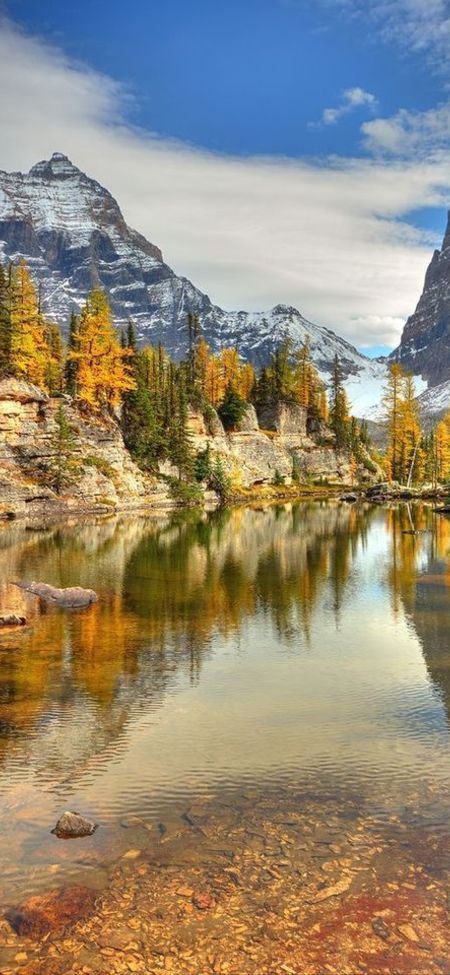
Discover the natural beauty of Cascade Lakes in Yoho National Park, where breathtaking landscapes will leave you enchanted.
0 notes
Text

🌟 Discover the hidden gems of British Columbia! 🇨🇦
Explore our handpicked list of the Top 15 Cities to Visit in BC. From vibrant Vancouver to charming Victoria, there's something for every traveler. 🌆🏞️
Check out the full article now here!
#TravelBC#ExploreCanada#BeautifulBC#CityScapes#Wanderlust#CanadaTravel#AdventureAwaits#BCExploration#TravelInspiration#MustVisitCities#travel bc#explore canada#tourism#travel#british columbia#beautiful bc#canada travel#canada#travel inspiration
1 note
·
View note
Photo
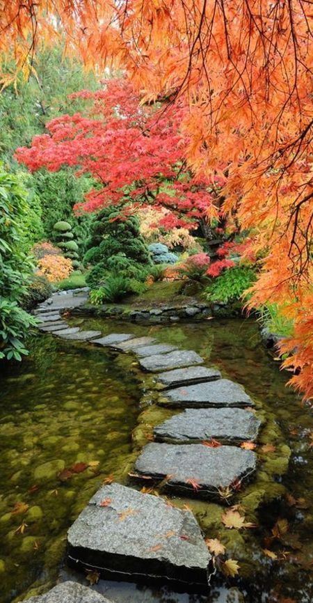
Butchart Gardens - Brentwood Bay, British Columbia, Canada
Expand your horticultural knowledge at Butchart Gardens, a captivating English garden located in Brentwood Bay, British Columbia, Canada. Wander through meticulously curated landscapes and gain inspiration for your own garden paradise.
0 notes
Text
wanna see the full 2 1/2 hrs of trees, mountains, wind, nature, mountain top, greenery.... go to my channel and relax:
youtube.com/brendonknoxvids
1 note
·
View note
Photo

I honestly love this photo so much. #numafalls #numafallsbc #travelbc #bc #travel #travelphotography #photography #waterfall #milkywaterfall #water #nature #canada #love #stunning #art #landscapephotography #landscape #mountains (at Numa Falls) https://www.instagram.com/p/CiwGiWwLRFP/?igshid=NGJjMDIxMWI=
#numafalls#numafallsbc#travelbc#bc#travel#travelphotography#photography#waterfall#milkywaterfall#water#nature#canada#love#stunning#art#landscapephotography#landscape#mountains
0 notes
Text
Check out our awesome youtube Chanel🥰
#travelfun#travelfamily#travelBC#travel2022#travelwell#travelingwithkids#travelshots#travelmood#travelgramitalia#traveltagged#travelessentials#travelingphotographer#travelart#traveladventure#travelturkey#travellersnotebook#travelphotooftheday#travelingyogi#TravelTheWorldWithScarlettRose#traveldestinations#travelwithus#Travelerslife#traveligram#travellingalone#travelmagazine#travellingindonesia#travelphotograph#travelfreak#travelaccessories#travellingaroundtheworld
0 notes
Text

2nd Annual Pender Harbour Winter Festival ❄️ 3-7pm, Saturday December 16, 2023 on Sunshine Coast BC Canada 🇨🇦 An outdoor event featuring a Christmas Market with Local Vendors, Santa’s Workshop with fun kids crafts, Live Music, Mulled Wine from the Net Shed Bar, Local Food Trucks, Photos with Santa, Bonfire & Christmas Carol Ships Boat Parade.
This Year we are offering GOLDEN TICKETS! A perfect gift for employees & families looking for #corememories. (Includes Admission for Two, Drinks for Two, Dinner for Two, & a Professional Photo with Santa). Please contact us at [email protected] to inquire about Golden Tickets. This is a Holiday Coast Event not to be missed!
Facebook page https://www.facebook.com/phwinterfestival
Instagram page https://www.instagram.com/phwinterfestival/
Sunshine Coast BC Canada Facebook page https://facebook.com/bc.sunshine.coast/events
hashtags #penderharbour #winterfestival #thingstodo #event #sunshinecoast #madeirapark #fall2023 #winter2023 #winterfest #madeirapark #christmas #events #sunshinecoastbc #britishcolumbia #canada #hellobc #destinationbc #travelbc #travelcanada
0 notes
Video
youtube
Aurora and Joshuah Bolton Amber Alert Western Canada
Aurora and Joshuah Bolton Amber Alert Western Canada. Over a week has passed and RCMP are still searching. Please take the time to watch the entire video and contact 9-1-1 if you see any persons in the video. THANK YOU #amberalert #amberalerts #centreformissingandexploitedchildren #missing #missingperson #missingchildren #canada #canadalife #missingkids #abducted #abductedchildren #missingpersons #rcmp #lawenforcement #police #policing #policenews #television #news #breakingnews #bolo #children #kids #family #bcstorm #BChighways #drivebc #explorebc #travelbc #travelalberta #explorealberta #kelowna #Kamloops #SurreyBC #FraserValley #MerrittBC #BCWilderness #bolton #AuroraBolton #JoshBolton #JoshuahBolton #RobertBolton #VerityBolton #AbraxasGlazov
0 notes
Text
Looking for a reliable and stylish car to rent in the Vancouver area?
Book Now at https://rentalcarbuzz.com/rav4
Welcome to our YouTube channel! Are you tired of being stuck at home and ready for some adventure? Look no further than our reliable and stylish Toyota RAV 4 XLE rental in the Vancouver area 🚗💨 Our free pick-up and drop-off services make it easy for you to hit the road and explore all that British Columbia has to offer. Choose from our two convenient locations and experience the power and durability of this user-friendly car, equipped with all-season tires for any driving condition. Plus, its compact size and fuel efficiency will help you save money while still having a blast on your trip 😎🌲 At our TURO rental service, we prioritize your safety and comfort. Our vehicles undergo professional cleaning and sanitation before every trip, giving you peace of mind during these unprecedented times. Our check-in process is seamless and our team is always available to answer any questions you may have. So why wait? Book now and satisfy your subconscious desire for freedom 🙌🏼✨
Book Now at https://rentalcarbuzz.com/rav4
#VancouverRentals #ToyotaRAV4XLE #TravelBC #AdventureAwaits
0 notes
Text
12 Day Travel Guide to British Columbia
I haven't posted in a long time but here's my 12 Day Travel Guide to British Columbia! #travel #travelbc #explorebc

View On WordPress
0 notes
Link
#Michaeldadson #Drmichaeldadson #Mikedadson #Drmikedadson #Drdadson
0 notes
Photo

Winter on the west coast.
Long Beach, Tofino, Vancouver Island, Canada
#beach#snowman#beachlife#rare#beautifulbc#beautifulbritishcolumbia#beautifulVancouverisland#vancouver island#travelbc#travelvancouverisland#daily view#dailyviewbc#dailyviewvancouverisland#tourism canada#tourismbc#photographers on tumblr#photooftheday#picoftheweek#picoftheday#original photography on tumblr#originalphotography
48 notes
·
View notes
Text
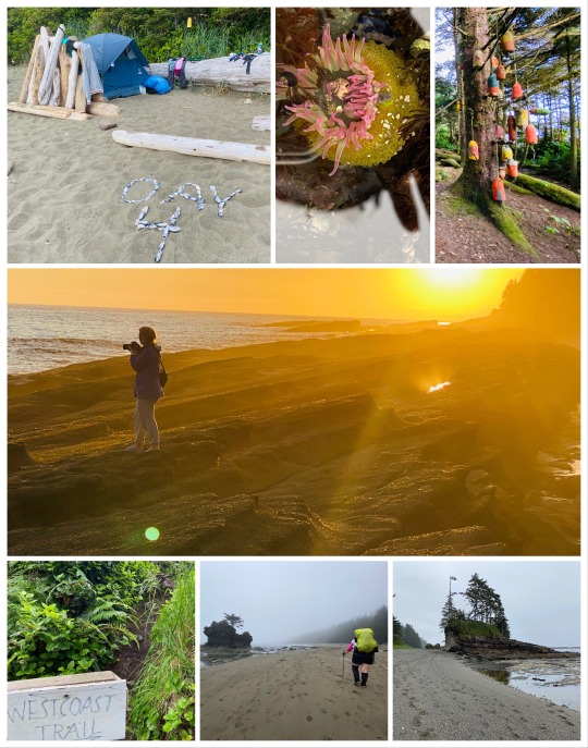
The West Coast Trail; A Vancouver Island Adventure Of A Lifetime
Packing: Food/Clothes/Essentials | Booking: Reservations/Transport | Research | Facts | My Story | Start | Days 1 2 3 4 5 6 7 | Chez Moniques | Nitinaht Crab Shack
The West Coast Trail is one of the most, if not the most, iconic Canadian west coast adventure a hiker could ask for. It is a 75km test of both physical and mental endurance in one of the most stunning environmental settings you have ever seen. Not everyone that sets out for this great journey completes it, but those that do have a tale to tell for a lifetime and a forever bond with those they meet along the way.
Having completed this epic trail twice now, my approach is to blend a little bit of old and new into a (hopefully) wondrous tail that offers context, wisdom and insight to the journey, while describing the magical things you will experience and the challenges you will face. I’ve also prepared additional posts for your reading pleasure on Packing: Food/Clothes/Essentials and Booking: Reservations/Transport. So please, grab a hot cup of tea, throw on those comfy pjs and sit back and enjoy the read.
Handy References and Information Material
Every great hike starts with research, especially this one! If you haven't heard of it yet, look up the famed book Blisters and Bliss: A Trekker's Guide to the West Coast Trail by David Foster and Wayne Aitken. This awesomely 80′s comic styled guide adds a little light-hearted humour to a highly detailed account of the WCT which is revised roughly every couple years. It offers both trekking options (north to south AND south to north!) and gives you all the step by step nitty gritty deets in between including history, objects of interest, geological features and safety tips! I suggest taking it with you and read about the section ahead each night. Also, opt to keep it in a safe pack pocket, don’t put it in a plastic bag (I did this my first time and sadly lost my copy to the inescapable moisture and mold).
Check out the West Coast Trail Facebook Page! This page is not manned by Parks Canada. However, it is a great place to meet other hikers, find someone looking to ride share, ask questions and for advice, learn about recent developments and important information (washed out bridges, danger sections, wildlife sightings or concerns... even hear about annoyed hikers picking up others garbage...not kidding lol).
Oh! And there is also a Women’s West Coast Trail Page!
Parks Canada Website. Duh, right?! But you may not realize that Parks Canada has some handy info regarding what to pack (and what not to!), emergency items, wildlife warnings, necessary fees, maps, tide tables, tips and more to make your hike a happy one. Check out the Planning For WCT page here.
You'll also find online a plethora of websites, blogs and articles dedicated to WCT info, tips, advice, and more. I encourage you to read a few personal accounts to get a real life feel of what others experience. Here are some of my favourites (don’t let the names scare you!), plus a very cool and scholarly article from UofBC on the effects of colonial-style tourism in the area and on the local indigenous tribes written in 2020. Fascinating read.
Hike The WCT (website)
Walking the wild coast : territory, belonging, and tourism on the West Coast Trail (UofBC Open Collection)
Lost On The West Coast Trail
How Not To Die On The West Coast Trail
The Facts
The West Coast Trail is 75 km long. That's on the map and, best as I can figure, relatively "as the crow flies". It does not account for the extra steps, the ladders, the climbing, the crawling, the descending, etc, you get the picture. Both times I've gone my fitbit has read almost double or more the distance in 'real ground covered'. For example, when they say its 5km from the Gordon River Trail Head to Thrasher Cove, my fitbit in both cases recorded over 12 km when all was said and done. When they tell you it takes on average 5-6 hours to do that stretch, and you're only covering 1km or less an hour, this is why. You will chuckle in the orientation, as many have, and think, "ya, if you're a SNAIL!", but you will soon realize it’s about the terrain and that you're essentially doing double or more the physical effort to cross it. The same is true for nearly all the trail, even the "easy parts".
Safety First - the majority of accidents and injuries occur in the first 13 kms on the south side of the trail, from Gordon River at km 75, to Camper Bay at km 62. The trail accommodates just over 7500 people a year. Of that, Parks Canada evacuates roughly 80-100 injured persons annually and Nitinaht villagers have claimed to ferry out 100-200 additional hikers off the trail as well, due to injury, misery, etc. It won’t be a bear or cougar that takes you out, it’ll be the wilderness itself. A fall from a wet log or slimy stone is the most common culprit, and it may not even be the fall itself, but what you land on. Sharp rocks, jabbing sticks, etc all cause serious injury. And it always happens when you're TIRED. Don't push yourself. Take a break, have a snack, don't go farther in a day than your body can handle. Better to be a day late than waiting 24 hrs in the bush with no morphine and a broken leg for a boat ride that surely will be agonizing. Just sayin' here...
The WCT historically was maintained for shipwrecked mariners. Many have lost their lives along this trail. I don’t understand how it doesn’t have its own ghost story yet! It has an amazing history with lots of ship wreckage to see along the way if you time the tides right.
Lastly, the temperate rainforest that engulfs the WCT is not only stunning but globally very rare, encompassing less than 1% of ecosystems across the earth. Here you will see plants, trees and animals that may not exist anywhere else on our planet. The Sitka Spruce for example is among not only the tallest trees in the world, but also the oldest, some 700-1000 years old. This means they have seen North America as it was before European Settlers touched it. They are revered by many and highly sought after by loggers, which often leads to conflicts. Many extremely unique animals also reside in the WCT, like the islands' black bears which are actually larger than mainland black bears with massive skulls and only one unique colour phase. The island is also home to cougars, Victoria's famous mini-deer and sea-wolves, the only wolves in the world that have adapted to life on a coastline, they call the Pacific Coast home. With a completely unique diet of seafood they are genetically different from mainland wolves and have also been known to swim in the ocean for many kilometers.
My West Coast Trail Story
Now, before we begin, I'll preface this by saying, don't mistake me for a pro; I am simply someone who has made it off the WCT twice [relatively] safely and lived to share my tale. If you are looking for expert advice I'd say check out the Parks Canada website or the Blisters and Bliss book. But if you are looking for a heartwarming and informative, real life account of the experience, you've come to a great place.
I am now amongst a lucky few that have had the enormous privilege to have hiked the West Coast Trail not only once, but twice in my lifetime thus far. I say thus far because this trail has such a special place in my heart I expect at some point I will likely attempt it again. It changed my life and has had an everlasting impact on the lives of those around me. I learned a lot about myself and even more about those closest to me. What I am capable of, the importance of preparation and planning, the bonds you create with people you meet along the way and the love of those that support you going and take care of things while you're gone. I simply couldn’t have done this without the support of my amazing husband, friends, parents and sister and my wonderful sister in law whom we stayed with this time. But most importantly I missed the encouragement and support of my mother-in-law who lived on the island and sadly has passed since my first trip. She and her friends played such an instrumental role in my first journey with my sister, buying us foods, housing us, driving us, and just overall being so excited to see us off, I truly missed her this time but I know she was there with me in spirit.
In this way the West Coast Trail is a life-shaping experience like no other. You will learn much about yourself, be in awe and hopefully inspired by the incredible natural world around you and you will meet fellow Canadians and global trotters and, in turn, become a part of their WCT story. Let me be amongst the first to congratulate you on this epic endeavor and wish you the happiest, and safest, of journeys and hopefully I can send you off a bit more well prepared for the adventure.
First Timers VS Second Timers
My experience as a first time WCT hiker was extremely different from my second expedition in every way possible.
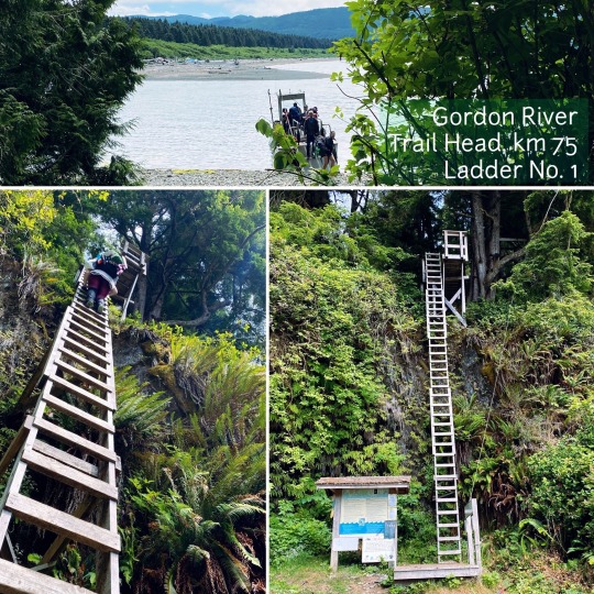
The first time I hiked the WCT I went with my youngest sister Jenna. We had both hiked and camped before but this was a new experience and everything was raw, a bit scary, amazing and beautiful all at once. I think it just hit us both like a ton of bricks when we landed at the base of that first ladder across the Gordon River. Although Sharon had talked to me for months, mentally preparing me for the hike, when Jenna and I both looked up at the rest of our start group scaling that first beast, looming up from the small beach landing, I know we both had the exact same thought, like, "oh shit, this is for real...".
Why the WCT? Sharon, my good friend and co-worker, had previously attempted it before turning me onto it. Due to an unfortunate incident with her hiking companion, they had to turn in the towel. She has since rocked it twice more and was an absolute wealth of information, support and the wisdom that only an experienced female hiker, mom and athlete can be. Much of what I am sharing with you today began with her. She continues to inspire me every day with her ferocity and determination and boundless want for adventure.
At the time of my first hike in 2016, my mother-in-law lived on Vancouver Island and she and her best friend Jill had kindly arranged for us to stay at another friend's cottage just outside Port Alberni. The friend and her husband fed us well and the beauty of the setting was unimaginable. But the anticipation of what lay ahead weighed heavily on both Jenna and I and neither of us barely slept a wink. The next morning we had our last hot shower and flush toilet experience for the next 7 days and the 4 of us set out for the Gordon River Trail Head.
We piled into Jill’s car the following morning. The ride was long, on gravel switch back logging roads, but the supportive company made the nervous anticipation bearable. I feel like I did not appreciate the ride as much as I should have at the time, but a few 5 am bus rides (and much experience) later, I certainly cherish the thought my mother-in-law and Jill had put into making the beginning special for us both.
Since then, I've booked my island hike transports with the West Coast Trail Express bus. The folks there are super helpful and the experience has always been a good one. In 2018, a WCT facebook group was created which has made connecting with others looking for ride shares and doing the trail much easier AND more informative! You can read about this page and other research options at the top of this post if you missed them ;)
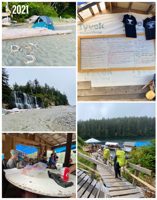
When 2016 saw Jenna and I land at Gordon River's Information Station, I was greeted with an amazing surprise... Sharon and Jackie (another friend) had pre-purchased for me a WCT t-shirt. I cried, there were no words. When 2021 saw Krista and I land at Gordon River's Information Station, I was greeted with a sense of the familiarity of the adventure and vicariously enjoyed the wonder of someone else now experiencing the trail for the first time... READY?!.. and INHALE... can you smell it..? the Adventure?! It's like greeting an old friend again, for the first time.
It's Like Those Choose Your Own Adventure Books, Where You Pick Your Ending...
Remember those..? Maybe..?
When Starting the WCT, you can plan to start at either entry point, Gordon River to the south or Pacheena Bay to the north, or now even halfway at Nitinaht. There are advantages to all, so it just depends what is most appealing to you. Most people do the trail within a 6-8 day time frame. This gives a good balance of time vs pack weight. I always try to plan for an extra emergency day, just in case. Things happen here... Long stays requires more provisions and a heavier pack. Shorter stays (in my personal opinion) are extremely challenging, unless you have done the trail before, are very skilled in lightweight packing and are an expert hiker. I still wouldn't recommend it. Plus, if you're going that fast, you're rushing by so much, what's the point? If you've paid and taken the time to be here, enjoy it! That being said, when Jenna and I did the trail we were treated to watching marathoner and athlete Jen Segger run it in one day. ONE DAY. She currently holds the women's record for WCT completion at 13 hrs 44mins (as posted here on her page under 2016). Of course she had no pack and support runners with her and a camera crew. But as she ran by us I think both our jaws dropped. It was like watching Super Woman run by you and you were just lucky if her sweat spayed you as she passed by.
When you start out, keep in mind your pack is at it's heaviest. Starting at Pacheena Bay entry point means you'll be hiking the easiest parts of the trail first. You'll make excellent time here and cover the most distance over the shortest number of days. Although all areas of the trail offer exquisite and unique beauty, in my opinion the north end is the most magical. Maybe because by the time I reach it Im half delirious and most certainly exhausted so the easier hike is a much welcome break. Both times I've hiked the WCT I have opted to start at the southern trail head point known as Gordon River.
Starting at Gordon River means that you get through the most difficult terrain right at the beginning, when you're freshest, well rested and eager to set out. You also have the added benefit of anticipating the terrain getting easier (rather than harder). To me, this is the most logical approach and why I prefer this route and honestly, there is just something that seems slightly disillusioning about expecting something to get harder along the way. When Jenna and I first made it up that initial ladder we came across several groups finishing their hike. One in particular stuck out, a group of three female friends. We passed the first two who were happy and chatting and weirdly gave us a (mild) warning to disregard their companion, who was somewhere behind them. Ok... sure, we thought. Then along came the third girl... muttering, swearing under her breath, we contemplated what she might do to her companions if she caught up to them and we joked about how that likely was the end of that friendship. 2016 was a much busier year, pre-covid and all, and we met so many more people, Canadians, Germans, Chinese and Auzzies!
2021 though is the year of the Canadians! If you happen to head out on the WCT this year, although you will still experience a wide range of people (Canada is an extraordinarily diverse nation!), rest assured most currently reside within Canada. Hello Homies! It was, however, a much more muted WCT experience than my past one. Although the Parks staff assured me they have had lots of people come through (I asked!), and the online bookings are sold out, it seemed so much quieter day to day. At the time Krista and I arrived, Parks staff were still only doing outdoor basic debriefing, prior to which we were expected to watch an online information video covering the basics. This was in stark contrast to the very in depth orientation Jenna and I had to attend back in 2016.
Fellow Canadians, Tsk Tsk...
The biggest difference I noticed that could be as a result of the minimized debrief is the amount of garbage. There is NO garbage removal on the trail. Parks staff DO NOT haul garbage out (its a remote wilderness, do you really expect garbage men??). The WCT is accessible by foot (as in, you hike in... for 75 km) OR by boat, the latter being weather and safety dependant in extreme occasions (ie emergency evacuation). At each campsite we stayed, hikers THIS year (the trail was closed 2020) have left copious amounts of garbage. It’s in the bear bins, on the trail, the beach, in the outhouses... it’s EVERYWHERE. The worst by far was Camper Bay with stinking tuna cans and bags in every bear bin and Cribbs Creek, where the garbage pile extended to a massive bottle collection BEHIND the bear bin.
Why do sites have bear bins in the first place? Because human food and waste smells amazing to BEARS! So we lock it away to keep it, and us, safe. This does not mean a bear can’t smell it, it just means they can’t access it. Now, what happens when food rots and gets stinkier...? Of course it's more enticing. This draws bears, and other animals, to the campsite, which puts your safety, and the safety of each camper, at risk. I have to give Krista major kuudos here because that girl dug in deep, cleaned someone else's mess at each site we stopped at and even hauled out other people's stinky gross trash. Please give her a round of applause for thinking about you because she deserves it. And as Canadians, seriously, we can do better right??

Da' Debrief
Apologies, now that’s out, let's get on. During our debrief we learned some important key points.
2021 has seen unprecedented amounts of animal sightings and encounters. Primarily bear and cougar. There has also been more daytime sightings of wolves, which is considered extremely rare. With the trail closed in 2020, lack of human presence has caused a larger wildlife presence. Be aware, practice safety, travel in groups. Groups are also being asked to accommodate single hikers to reduce risk.
There is a lot of maintenance to be done that wasn't able to be accomplished in 2020 due to the pandemic. Be prepared for washed out boardwalks, bridges and rotten boards. There is also fewer Parks staff to help with this upkeep. Luckily, local members of indigenous tribes, called the Trail Guardians, historically help in a huge way with this and you may even run into them on the trail! We saw their team arrive in their new boat leaving Walbran and at Pacheena we spoke to a Parks staff who's uncle is on the team. It's a small world here.
Following the debrief, the Parks staff escort you to the Gordon River ferry. The fellow here takes you across and plops you down on the small sandy beach, gathers up any hikers waiting for a ride back and heads off on his way. And there you are, left to stare at a huge ladder, really, the first of many.
up, Up, UP You Go!
In 2016 Jenna and I patiently waited at the end of the line to be the last two up the ladder and I tackled the climb with my 50lb pack in tow (phew!). In 2021 Krista and I were the only two standing on the beach, me revelling in my 'barely there' 38lb pack. The trail was our oyster!
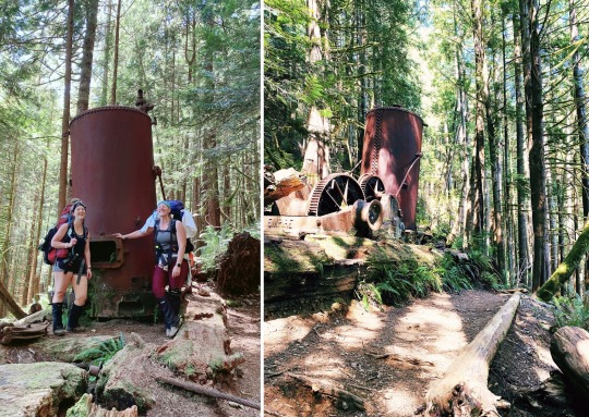
The trek from Gordon River to Thrasher Cove is the most challenging and physically demanding on the trail. We left on the 11:30 ferry and finally walked into Thrashers Cove at 5pm - Yes, it DOES take that long. You actually don't see many ladders, a few here and there, but best believe you are still climbing! You scramble up rock faces, you squeeze past trees, you choose your footing extremely carefully and all the while up, up, UP you GO! Even over rocks and hard ground the trail is fairly well worn and easy to follow... most of the time. A short while in you come to the first bridge over the first creek. I have stopped here both times to fill up water bottles, but beware, the scramble back up is more difficult than it looks this year due to the fallen trees. Mountain Goat level scuttling expertise is advised! Much further along, not far from Thrashers, you'll eventually comes across the famed Donkey Engine! This year you will find it to be directly in your path, where as in 2016 I’m quite sure we looked down on it somehow from a higher elevation. Either way, it’s epic and makes for an amazing photo op! To think that thing was hauled by beast and hand up that hill still blows my mind.
Along the way we met a very nice gentleman named Wilson who had intended to hike the WCT with his son. Unfortunately, due to a graduation re-scheduling mishap his son was unable to come, but Wilson decided to soldier on. He was incredibly happy, thoughtful and polite and asked if we minded if he tagged along as we hiked. He regaled us with tails of his trails, immigration to Canada, his wife and family and much more; he was a fascinating fellow! With the wildlife warnings this year, Parks staff request that no one hike alone, if you can, allow a solo hiker to tag along so everyone can stay safe. We graciously obliged and enjoyed his company and great conversation for a couple more days until we parted ways at Nitinaht comfort camping.
Thrasher's Cove is an amazing, but small, campsite. I recall vividly in 2016 the trail down to the beach being extremely treacherous, with steep and slippery embankments and so many ladders! By comparison our 2021 descent seemed like a cake-walk. Here I was, boasting to Krista the challenge that lay before her, but when we got there it was literally a quick hop and skip down. She found anything I said after that to be hard to believe and was convinced I was totally embellishing. It really made me realize how MUCH the trail changes and what dynamic metamorphosis must have occurred in 6 years! I also realized how hard Trail Guardians and Parks staff must work to maintain all this constantly worn out infrastructure. It must a BEAST. Be warned, if you arrive to Thrashers too late in the day it will be tough finding a spot. If this happens to you, check out the south side of the beach, sometimes there's a bit more space there. Ironically, I have set up my tent in the exact same spot both times, right in front of the tiny triangle cave around the rock wall on the south side of the beach. I have claimed this spot now.
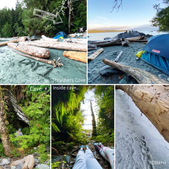
Knock, Knock, It's The Ocean!
This is also where knowing how to read your tide tables is extremely important. While camping on the beach you must pitch your tent above the high tide line. The high tide line is where you can see the sand was last wet on the beach. It's not where the water is when you arrive. Look for the wet point on the sand and keep your tent a few good feet above that. When Jenna and I first arrived at Thrashers, I was confident in my tide table reading skills; being from Alberta, I took the time to learn how to read them in advance. But, during the orientation the Park staff had warned our group that our first night was due to be the highest high tide of the year - intimidating to a couple prairie girls! And, which is also a thing if you read up on the moon cycle! (Actually there is a lot of news this year on the effects of the moon's impending orbital wobble on tides, its a fascinating read if you're interested!). So, naturally a bit cautious and overly leery of the horror stories of campers waking up to soaked tents in the middle of the night, my poor sister was worried sick. Exhausted but too afraid to sleep, I promised her I'd stay up till high tide to make sure we were safe. She soon passed out and I settled in reading my book. But the surf was loud and near, a thundering, crashing rukus with each wave and about 2 hours in my sister jolted straight up in her sleeping bag, scaring the ba-geezus outta me crying out 'IS IT HERE?! IS THE OCEAN HERE YET?! ", big-eyed I just stared, then broke out laughing; I settled her back down, reassured her we were safe, now passed the time of concern, and wiggled down into my own sack to drift off. It's still an inside joke to this day and once in a while we chuckle to each other about the time the ocean came knocking.
2021 brought me its own surprise when at 4am I awoke to an unusual scratching noise against our tent next to my head. We had wrapped our rain covers around our [empty] backpacks and snugged them up against the tent to stay dry and save space. Apparently the local otter family found them fascinating and decided to check them out on their morning stroll. An alarm clock certainly fit for the WCT.
It's A Beach Walk, Not A Cake Walk
Leaving Thrasher's Cove you have two options! You can take the beach route if you time the tides carefully OR you can take the inland route. In 2016 Jenna and I sojourned the inland route. Although the inland hike was pretty, if I'd found the trek down to Thrashers tough, the trek back up would've been classed insane. Sharon’s favourite saying is, what goes down must go up.
In 2021 Krista and I timed the tide, leaving at 7:30am, to take the beach route. Although we'd planned to avoid what turned out to not be a bad climb, I'd really wanted to see the famous sea caves! The sea caves themselves were nothing short of AMAZING. There is just no other word. I was so in awe that in my mind they seem to take up almost 3 days of our trip, not just half an hour on the second day.
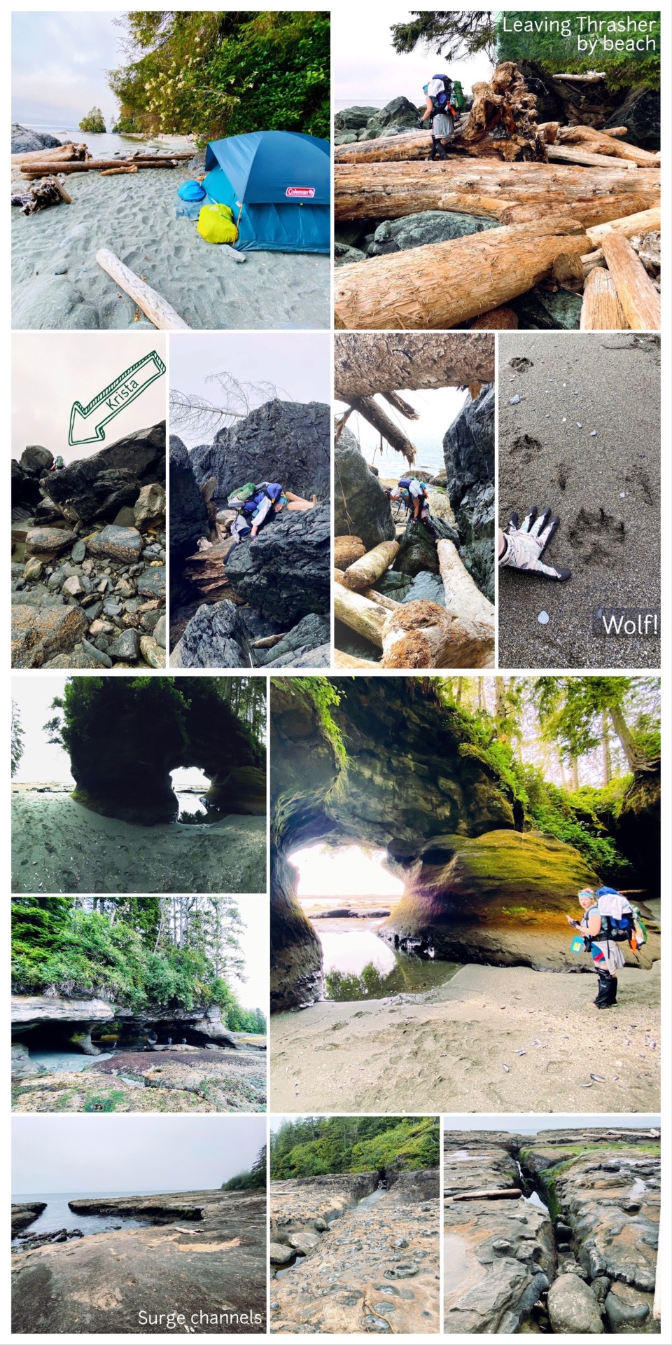
Although we'd planned to aim for Cullite Creek Campground day 2, we hit a major snag. As we traipsed along, well after the sea caves, we came to a rocky sea shelf that rose high out of the water. As you look up, you might catch a glimpse of some buoys, which commonly mark the beach access to the trail and campgrounds. Thinking this was our access back onto the trail, as you must go inland from here to Campers, we headed up along the higher shelf. We passed an unusual 'Danger' sign. We looked around, but could not identify anything that seemed out of the ordinary for where we were. We kept on. We came to a similar sign on the rock, but again, failed to see what was obviously dangerous. Wasps? Bear den? Surge Channel? There was no fallen bridge, no down ladder. Everything seemed ok. We reached the buoys, and Krista lifted her leg to step over a small trickle of a water... That's when it happened.
Danger on the Trail...
Before she could even complete her step, both feet flew out from beneath her and her whole body, pack and all, smashed onto the rock shelf. She began rocketing like a she was on a pro waterslide down the embankment towards a 9 foot drop into the water pool below. I had the wherewithal to shout out 'grab a rock!', and in the 3 seconds that seemed like 3 hours, I had the presence of mind to ponder how I might explain this to her mother back at home and 4 year old son if things went sideways... but with a 38lb pack on myself and being a few feet behind, there was no way I could move fast enough to do anything but yell.
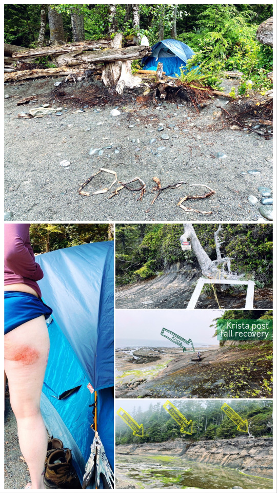
Luckily, mid-slide, she managed to grab a handhold just long enough to stop and get some footing. Crisis averted, but the damage was done. Wearing shorts, she was sporting some nasty road rash on her cheek and arm, but most of the damage was buffered by the hoodie she'd had tied around her waist. She was bruised, but she was lucky.
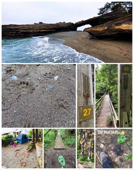
Feeling pretty roughed up, we opted to stay at Camper Bay instead and rolled in about 1pm where we washed and treated her ailing buttocks and gave her some much needed pain meds. Along came a few more groups and we felt a bit less sheepish learning 2 of them had also had the exact same experience. Pride slightly less wounded, we made some new friends for the chatter and laid back and chilled for the afternoon. On your parks provided trail map, you will see a small note in red pointing to BA 'B' (beach access B) that warns about a dangerous slope just past the surge channels after Owen Point. It's not kidding.
If you stay at Camper Bay, it's a lovely and large campsite with lots of room for everyone. However, it has a habit of getting very windy, like all the time, and the only time it's not is when the sun goes down. If you're early enough, grab one of the sheltered tent spots in the woods/taller grass along the creek side. It also has a rep for early morning rain and fog. Something about the geography here seems to create its own micro-environment. If you walk out along the beach at low tide and cross the creek to the north, you'll see some neat tidal pools and caves in the rock wall. In the one with the small pool of water you might see a single lonely fish with the pool all to himself. I hope one day the tide washes him in friend.
Reminiscing...
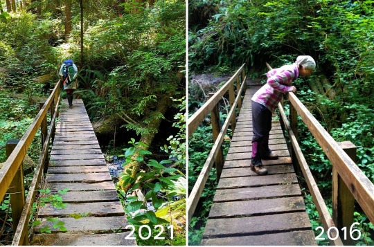
Ironically, day 2 in 2016 was also the day I had a mishap of my own. Tired and worn down, toddling after Jenna across a log bridge the width of my car, I misstepped. My feet were somehow gone and in a second I found myself sitting on my ass, straddling the log instead of walking on it. I peered down into the 6 foot drop below. Completely in disbelief I suddenly realized Jenna was yelling at me "Are you OK?!" ... Yes! I was! I was ok. Nothing was broken, hurt or otherwise. But it was a wake up call. If you are tired, take a break, don't push on or try to keep up with someone faster. Only hike as fast as your slowest hiker and be patient. Take a breath and remember, the goal is no one dies out here... hopefully.
Gone Are The Days Of Legendary Mud And Tilting Ladders That Make You Poop ... Just A Little
The few days that followed are a bit of a blur. There's so much to see and so little blog space to include it all! We left Campers Bay on a foggy, rain mist morning at about 10am. Since we had to take the inland trail there was no worry about racing the tide on this stretch. We chatted with the couple we met the night before (Mat and Lauren from Calgary!). Everyone was a bit tired that morning.
Although we saw some mud, with a historic heat wave just prior to our trip in 2021, the legendary mud pits that the WCT has typically been known for were non-existent. In 2016 Jenna and I spent most of our inland trail time figuring out how to cross mud-holes, watching where each other stepped and trying not to fall in up to our armpits (I kid you not). This time, there was no mud and if you disagree with me, go again after it rains. I dare you.
This is also the section where we saw the most ladders, most notably through Cullite Creek, which was sadly such a trickle there was no need for the cable car, we just rock hopped across (with ease). We saw some really cool art done along the trail by the Guardians in the new bridge and log cuttings, some even signed their names! Have you tried making a curve with a chainsaw? I was impressed.
This section also has a neat and unique stretch of boardwalk that goes through a fragile wetland. Sections of the boardwalk were out, it looks easy, don't let it fool you!
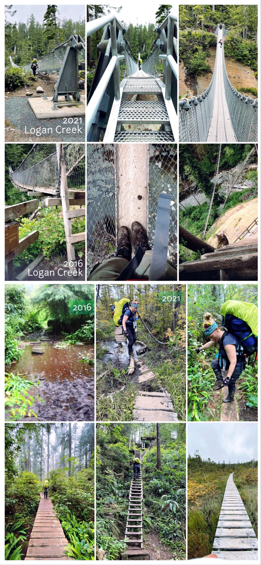
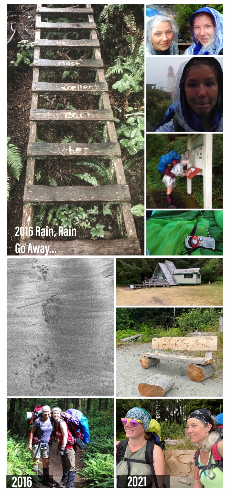
A brand-spank'in new suspension bridge calls Logan Creek home! In 2016 Jenna and I had to climb a harrowing series of crazy, half-tilted ladders to get to the bridge. I recall my favourite as being the third ladder in a tower, that was so amazingly on a 10 degree angle sideways, and scaling it with my 50lb backpack. It was all I could do not to roll off and meet a perilous end at the bottom of the gully. Today the beautiful new bridge almost disappointed with the ease it took to cross it. NO more ladder climbing, you just walk up the stairs and off you go!
We arrived in Walbran Campsite at 5:30, the creek is perfect for swimming if it’s warm enough. Several groups had a run-in here with a couple breaking the fire ban policy. People on the WCT take this seriously, keep in mind if you start a forest fire here, there’s no where to go and it puts the homes of indigenous peoples at severe risk too. We all simmered, had a tasty meal, chatted with our travel companions, explored the beach a bit and turned in for the night, thoroughly exhausted.
We spent the next two days going from Walbran Campsite to Cribbs and then to Tsuisiat Falls. Due to a problematic and confrontational cougar in 2021 there is no camping permitted along the trail between kilometer 34 to 38. So, naturally, your last stop prior to Nitinaht Narrows is Cribbs Creek.
The Stretch from Walbran to Cribbs is basically all beach walk. The beach is lovely, but don’t let 'beach walk' fool you. It’s just as challenging to walk in sand as it is through forest... and you thought it was going to be easier, didn’t you?! It's like walking through snow without snowshoes and being 30lbs heavier...what a Canadian thought. But! Fear Not! along this stretch is also the famed Chez Moniques burger stop and the Carmanah Lighthouse! The lighthouses are closed to the public this year due to covid, but it’s still a sight to behold as it beams brightly through the fog.
The Legend That Is Chez Moniques
In 2016 Jenna and I made a critical, but common, food planning error. We packed meals based on what we felt was healthy and would give us energy, without accounting for taste. In other words, we packed a lot of dry lentil-based meals that tasted awful and took forever to cook and I couldn't have forced down my throat if you had paid me. I love beans, but dried lentils on the trail... yech! You can read more about our cautionary tale in my food section, and if you're uncertain about foods to pack, it’s worth the read!
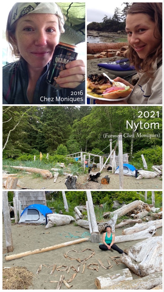
So, sufficed to say, that year we had the absolute pleasure of experiencing Chez Moniques in it's prime. It was incredible. Here we were, in the middle of nowhere, exhausted, starving (I was anyway lol), and run off our feet. And out of nowhere arose this mirage of a tent with burgers, fancy meals, peach ciders and more! My god it was intense. We kicked off our boots, stuffed our faces, chatted with Monique, the legend herself, and I protectively cradled the best Okanagan Cider that had ever touched my lips while we waited for the tide to recede. It was magical.
Sadly, between 2017-2018 both Monique and her husband tragically passed away. It was a blow felt around the world by all those who had passed through their doors and experienced their generosity. There is a lovely documentary attributed to their memory here. Today, in 2021, following a devastating 2020 with no business, Monique & Peter's grand-daughter, Katrina Knighton is trying to carry on the dream though the restaurant will be renamed as Nytom. We heard lots of chatter and some hikers did actually see her in person, but unfortunately there are some struggles, including keeping up supply levels, which they are walking in for 1.5 hours (!). We missed them this year, as did many hikers, and I was so sad Krista would not experience it. But! They are rumoured to have services most often morning and around 5pm. Katrina is also very active on the WCT Facebook page, so feel free to drop her a line there for more info!
We arrived in Cribbs Creek at about 2:30pm. It was the end of our Day 4 and what a campsite it was. Lovely soft sand under your toes and beautiful beach. There is nothing here for swimming but we had the most amazing sunset view on the rock shelf that night. Although it didn't rain while we were on the trail, this was the first time we'd seen the sun since we left Victoria.
youtube
The Magical Beauty Of Nitinaht And
The Crab Shack Of Your Dreams
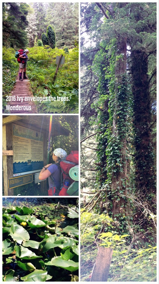
We left Cribbs Creek about 9am and stuck to mostly inland trail. Other hikers going the opposite way had warned it was very overgrown but we honestly had no problems with it; it was a little underused, but keep in mind they hadn't seen the south side yet. We made excellent time and arrived in Nitinaht Narrows at 1:09pm. The journey is absolutely stunning. There is a new bridge over the creek at Dare Beach and the forest walk is lovely. The bridge over the Cheewhat River offers great views also. You cannot take water from the river itself but after the bridge there is a freshwater stream marked by a wooden sign if you need it and soon you will come across an old Cabin. When you arrive here, turn around and see the new and amazing Ditidaht home across the river. It has changed a bit, likely with the drought, but in 2016 Jenna and I referred to this stretch as "the place that Disney films are based on". Ivy clung all the way up the trees and just as you wrapped your head around that, the trail winds it's way through a silent coniferous forest where you could almost hear a pin drop, followed by a magical wetland lake with flowering lilly pads the size of your head. But none of this compares to Nitinaht Narrows.
As you walk along the trail, just a few short minutes past the lake, the path will turn from boardwalk to dirt and as you round the bend you will suddenly walk, with no warning, right into Nitinaht! It has caught me by surprise each time. We strolled down the walkways to the dock, left our packs safely on the bench and made our way to the Crab Shack. The blue-green waters of Nitinaht Narrows is something to behold. When you peer over the side of the wharf you see schools of small fish so thick you could almost surely touch them. When I dream of paradise, I dream of here.
Nitinaht Narrows was only recently made an 'official' entry and exit point by Parks Canada in 2014, you can read more about it here. But prior to this, older community members witnessed the inception and rise of the WCT as we know it today and watched it grow. Ferrying hikers across the narrows has become a task handed down from generation to generation. Connected to the ocean, it has tides about 10 minutes apart and historically, many years ago, hikers did drown trying to swim across before getting swept out to sea, naively misjudging the calm-looking waters. About 3 kms past the narrows, the Ditidaht band offers comfort camping options to those looking to settle and day hike the trail or in need of a break from the grind. This is marked with a sign and you will see it on the trail. The crab shack itself has also recently built new cabins as well which start from roughly $100/night (houses 4 bodies and you use your own sleeping bag) and goes up to ($200 and $300) where bedding is provided. They also offer tent platforms for a modest $30/night fee.
The Nitinaht Crab Shack is owned and operated by the Edgar family. They are kind, light-hearted, hospitable and will make you the best meal you have ever had. They work extremely hard and have a great sense of humour. A family member told me the previous day they had served a group of 20 lunch all at the same time! Hippie-Doug was their ring leader that day and he manned the ferry, that took us across the narrows to complete our journey, along with a sweet old chocolate lab you will see in many a hikers' photos. If you catch him at a slow moment he might share a joke and and story with you. But don't leave until you have warmed yourself thoroughly by the wood stove, had the best meal this side of Canada and picked up some treats for the road. The ferry finishes for the day at 4:30pm and then Hippie-Doug settles in for a much deserved break, a meal, and maybe a drink, so don't be late!
youtube
Tsu-Tsu-Tsusiat!
We left the warming comfort of the Nitinaht stove at about 3pm and headed on our way. We saw our new friend and traveling tag-along Wilson off at the Ditidaht Comfort Camping site and continued on, arriving at Tsusiat Falls by 6:30pm. You can't see the falls from the beach, but if you reach the hole in the wall at Tsusiat Point, you're just minutes away.
In 2016, the first 5 days of our hike Jenna and I had the most amazing weather. On our 5th day, after the crab shack, while the sun beamed a balmy 25+ C, we ditched our packs on a slope of sand with gentler waters between Nitinaht and Tsusiat Point and ran into the ocean up to our knees, jumping the waves and being astonished at their strength. We laid on the beach afterwards and soaked in the sun. When I think of my little sister, I often think of this carefree day and smile. Enjoy the journey as you go, or you’ll miss the best parts.
Tsusiat Falls is a popular campground. When we arrived the beach was packed. According to 2021 Parks regs, you can only stay one night here to minimize environmental impact. The beach was very different from what I remembered, but the falls were ever glorious. We threw on bathing suites and while Krista enjoyed the brief sun, I took a dip in the beckoning water.
The next morning, with Krista not feeling hot, I'd aimed to get up early and walk back to the Hole In The Wall with my Nikon DSLR camera. When we passed by the day before it was high tide and the Hole was under sea water. However, after a delay, Krista decided to come with me. We packed up, left our bags at Tsusiat and strolled back to the hole together, and a better decision it was. I’d watched a group ahead of us pass through an hour ago, but beneath their tracks you could make out a fresh set of cougar prints. Since low tide was at 10am that morning, that means the tracks were very recent and could only have been made since the water receded. Food for thought.
Darling Bears You Might Be Cute, But I Don't Want To Snuggle
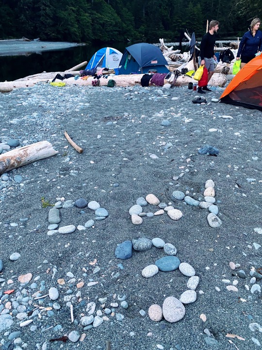
The last 2 days on the WCT (or your first two, depending where you start) are the easiest to hike and where you make up the most ground. We'd intended to land at Darling River Campsite (approx km 14), which from Tsusiat (approx km 25) would make it about an 11 km day. Most of our fellow travellers whom we had become familiar with were aiming for Michigan Creek though, which would add 2 km to our 6th day, but save us that on our 7th and final day out. We decided to see what the day held and if we arrived at Darling early we might continue on. WELL.... what the day held was not entirely what we expected.
In 2016 Jenna and I walked the beach hike between Tsocowis Creek and Michigan Creek. It had started to rain the night before and by morning was a light, but steady, downpour. We donned our rain gear but by noon, and halfway through our distance, it was clear that Jenna's rain jacket was not waterproof. Though she had tested it prior to leaving, it turned out not to be up to WCT-level rain. As we continued on poor Jenna got wetter and wetter and by the time we reached Michigan, she was soaked through to the bone. Water pooled in her boots, and she shivered so hard she couldn't help me with the tent. Realizing this could get worse quickly, I popped the tent, got her changed and snugged into her sleeping bag ASAP. Then I worked on adding a tarp. When the shivering stopped we got a warm meal into her and passed our time taking turns winding up our emergency radio and trying to maintain the faint signal from a long forgotten US talk station till darkness fell. It poured the entire next day as well for a total of over 24 hours straight and our photos at the Pacheena lighthouse are in plastic emergency ponchos.
In 2021 Krista and I opted for the inland trail as we'd previously made better time this way. There is lots to see here, another Donkey Engine and a rusty old grader, and I absolutely love the Billy Goat Bridge. The trail threw us for a bit at Tsocowis Creek, there, phantom branch-offs seemed to lead off and abruptly stop. You have to go down the ladders to continue the inland trail portion (OR access the beach). However, just passed Orange Juice Creek, it was quite clear this section of trail was not well used recently... by people anyway. It was eerily dark, overgrown and passed by what looked like long lost abandoned campsites in caves along the rock wall. As we passed by we heard something stir in the dim light, knocking over an old cup, and we nervously quickened our pace. We began to see pile after pile of fresh bear scat, some so fresh that by the time we reached Darling we figured we must be just behind it. Making a lot of noise we made our way to the beach and relief washed over us as we recognized people half a km ahead... our fellow Albertans, Mat and Lauren! But when they stopped suddenly and started to back up we knew something wasn't right.
Just ahead of them on the beach was our bear. And big guy he was! They figured a lone male. They managed to scare him off and once we caught up the 4 of us made our way as a group to Michigan Creek just down the beach where we figured there was relative safety in numbers.
youtube
Bitter Sweet Goodbyes
Our last day from Michigan to the Information Station at Pacheena was a super short one. We were the last hikers to leave Michigan at 8am and among the first ones (ironically) to reach the Parks office at 11:01am. The path is very well maintained and an easy hike. You'll also see a lot of day hikers here, many with dogs. Along the way are some cool sights you won't want to miss, so don't be too quick to rush out. The abandoned dirt bike isn't going anywhere fast anymore, but be sure to check out the sea lion rock just passed km 10. You may even hear them from the trail! Just before the sea lions you'll also pass by the Pacheena Lighthouse. Again, due to covid, you cant access the grounds but you can totally snap a quick pic! The area has so much bear activity Parks Staff joke about running 'bear daycare' here so be vigilant. Two wonderfully enthusiastic young ladies we met along the way carried an amazing tune; Im sure they must've charmed away any "would be" encounters.
In 2016 there was no km 1 sign on the trail and in 2021 there was still no km 1 sign lol. Both times I raced past km 2 and then later wished I'd taken a pic with it. You'll want it as proof! We walked the very last km along the beach, where firm sand makes for easy going. There were bear sightings of a mother and cubs here just before we arrived. We missed them, but were lucky enough to get some great foot-print photos. The very last bench you'll see on the trail is emblazoned with the word 'PARKS'. We sat here for an eternal minute and took some photos. As we strolled towards the Information station I couldn't believe it was over again so quickly.
Looking back, even after time number two, it feels more like a dream. The first time I walked off the trail in 2016 I eagerly anticipated a hot shower, was thoroughly disappointed at finding I had no quarters for to pay for one and I spent the 5 hour bus ride home starving and trying to sleep on a roller coaster. Perhaps not such a glorious end, but I realized I had achieved something few people would in their life time and of that I was SO proud of Jenna and myself. We did it.
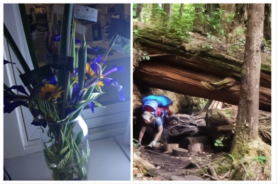
When I arrived back at work Sharon had the most glorious little bouquet of flowers for me and she glued tiny cut out flags of all the major trail milestones to skewer sticks throughout. It brought tears to my eyes.... she told me this, "for a while, you will think to yourself, I am NEVER going back to that EVER again. And then, slowly, you will forget all the bad parts and the thought will creep in... maybe, perhaps, I might try it again... and you will find yourself looking it up once more". And she was right, I did. And I am so glad I did... I might even do it again.
2 notes
·
View notes
Photo

Floe Lake | Kootenay National Park | Canadian Rockies | British Columbia Canada 📷 @yurichiffoleau . Share your Rocky Mountain photos here: The Rocky Mountains Community Outdoor adventures: The Rockies Collection On IG @therockiescollection Guides | Maps | Destination Information on website (US & Canadian Rocky Mountains) . . #kootenaynationalpark #kootenaylife #travelbc #canadianrockies #wanderlust #exploremore #explorebc #bcisbeautiful #rockymountains #hike #hikemore https://www.instagram.com/p/CTKdYzqFet1/?utm_medium=tumblr
#kootenaynationalpark#kootenaylife#travelbc#canadianrockies#wanderlust#exploremore#explorebc#bcisbeautiful#rockymountains#hike#hikemore
1 note
·
View note
Photo

Such a fun trip! #numafallsbc #numafalls #photography #iphoneography #nature #naturephotography #river #milkyriver #bc #pretty #beautiful #travel #travelbc #canada (at Numa Falls) https://www.instagram.com/p/CiwGHLTr2G0/?igshid=NGJjMDIxMWI=
#numafallsbc#numafalls#photography#iphoneography#nature#naturephotography#river#milkyriver#bc#pretty#beautiful#travel#travelbc#canada
0 notes
Text
Introducing the Hidden Gems of B.C. Tours!
Hey everyone! My name is Lina and I am one of the founders of Hidden Gems of B.C. I can't wait to share all the tours we have created to show you all the incredible Hidden Gems that you can explore in B.C. There is a reason why people refer to B.C. as Beautiful British Columbia and we'll make sure you see the most of what the province has to offer. We promise that there's something for everyone who decides to join us on one of our 6 tours! I won't keep you waiting any longer, let's meet the Hidden Gems of B.C. Tours!
1. Taste the World Tour 🍔🍣🌮🍜
Are you a foodie? Love trying different types of cuisine and experiencing culture through food? Well this is the tour for you!
Join us on our Taste the World tour to try the secret food spots around British Columbia that most locals aren't even aware of! We will take you through a culinary adventure that you will never forget. Trust us when we say, your tastebuds will thank you after the Taste of the World tour held by the Hidden Gems of B.C.
2. Sea to Sky Tour 🌊⛰🌌
⭐️ MOST POPULAR TOUR ⭐️
Are you looking for adventure? The Sea to Sky tour is a perfect match if you love exploring the outdoors! As British Columbia is known for it’s greenery and abundance of nature, we thought it was necessary to dedicate a tour to encapsulate B.C.‘s natural beauty. Travel from Vancouver to Whistler, take a hike up to a gorgeous view and end the night with a beautiful stargaze. So what are you waiting for!? Get your hiking gear ready for the Sea to Sky tour at the Hidden Gems of B.C.
3. Mountains and Oceans Tour 🏔🌲🌊
Who doesn’t love a good view? Well we’ve got a list of the most epic scenic views all over British Columbia that we would love to share with you! You won’t want to forget your camera on this tour as you’ll be seeing incredible ocean and mountain views. You will also have a chance to see iconic landmarks all over downtown. Improve your Insta-Game on the Mountains and Oceans Tour available at the Hidden Gems of B.C.
4. Sunset Tour 🌅 🌄🍷
💛 LINA'S FAVOURITE TOUR 💛
British Columbia has the most stunning sunsets no matter where you are! Enjoy a day of delicious food and wine tastings in Kelowna. There is no better way to end a day than watching a colourful sunset in the mountains. You will feel peace and serenity on a whole new level. This tour is perfect for you if you're looking to treat yourself to a relaxing day. You deserve it! Get ready to be in awe with the Sunset Tour only available at the Hidden Gems of B.C.
5. Escape to the Island Tour 🌾🏝🌊
Take a getaway trip to between the islands of Victoria and Nanaimo and see the beautiful Pacific Ocean in all it's glory. The Escape to the Island Tour lets you feel the waves and smell the ocean breeze. Feel one with the ocean by learning more about the diverse ecosystem that lives within the islands. Maybe we'll see some sea lions and whales along the way! Only on the Escape to the Island Tour at the Hidden Gems of B.C.
6. Pairing with Wine Tour 🍷🥪🏞
Calling all wine enthusiasts! Get ready for the tour of your dreams! Even if you're not a wine expert, you can learn to become on with our Pairing with Wine Tour! Take a day off with us in the Okanagan Valley where we will have experts guide us through the perfect food and wine pairings. Become a wine connoisseur in a jiffy with the Pairing with Wine Tour at the Hidden Gems of B.C.
⟹ Learn more about the Hidden Gems of B.C. Tours!

#hiddengems#hiddengemsofBC#Vancouver#Tourism#Travel#Explore#ExploreBC#Tourguide#HiddenGems#HiddenGemsofBC#TravelBC#Victoria#Nanaimo#okanagan
1 note
·
View note
Last Seen Blogs