#temblor range
Text

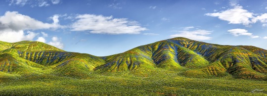
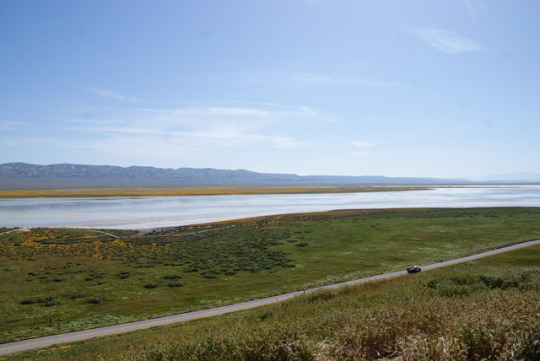
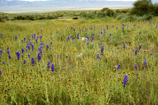
An explosion of wildflower species appears to paint Temblor Range, a mountain range that rises from the east side of the San Andreas fault at Carrizo Plain national monument near Santa Margarita, California, US. Spectacular wildflower blooms, referred to by some as a superbloom, are occurring across much of California following a historically wet season that drove 31 atmospheric river storms through the region, resulting in widespread flooding and record snow depths in the Sierra Nevada mountains. The extreme weather comes after years of record drought for most of the state
Photograph: David McNew/Getty Images
#david mcnew#photographer#getty images#wildflowers#aerial photography#temblor range#san andreas fault#carrizo plain national monument#santa margarita#california#nature
12 notes
·
View notes
Text
The Temblor Range after the morning rain 4/3/2023. The incredible beauty of a California super bloom.
5 notes
·
View notes
Text
What are the symptoms of parkinsons?
Parkinson's complaint is a complex neurological condition characterized by a range of symptoms that can significantly impact diurnal life.Dr. Shrey Jain, a distinguished neurologist specializing in movement diseases, sheds light on these symptoms to enhance mindfulness and understanding.
Symptoms of Parkinson's Disease
temblors Involuntary shaking, frequently starting in the hands, fritters, or branches, especially at rest.
Bradykinesia Slowness of movement, making simple tasks challenging and leading to stiffness and dropped range of stir.
Muscle severity Stiffness and resistance in muscles, causing discomfort and affecting mobility.
Postural Insecurity Difficulty in maintaining balance and collaboration, leading to an increased threat of cascade.
Changes in Writing Handwriting may come lower and further confined, known as micrographia.
Loss of Automatic Movements Conditioning like blinking, smiling, or swinging arms while walking may reduce.
Speech Changes Speech may come softer, vocalized, or monotonous.
Non-Motor Symptoms These include depression, anxiety, sleep disturbances, and cognitive changes.
Shrey Jain's perceptivity
Jain emphasizes the significance of feting these symptoms beforehand for timely intervention." Parkinson's symptoms progress gradationally, but early discovery allows for better operation and bettered quality of life. Seeking technical care is pivotal."
Expert Guidance and Support
Shrey Jain's approach to Parkinson's complaint involves a comprehensive evaluation to knitter treatment plans." Each case gests Parkinson's else. Our thing is substantiated care, encompassing drug, curatives, and life variations."
Advancements in Treatment
Jain remains at the van of innovative treatments and exploration." We explore cutting- edge curatives, including Deep Brain Stimulation( DBS) and novel specifics, seeking to offer the stylish possible care and ameliorate issues."
Empowering Cases
" Education is crucial,"Dr. Jain asserts." Understanding symptoms helps cases laboriously share in their care. We aim to empower individualities and their families by furnishing comprehensive support and guidance."
Conclusion
Parkinson's complaint presents multifaceted challenges, but early recognition and technical care, guided by experts like Dr. Shrey Jain, pave the way for bettered operation. Through continual advancements and a holistic approach ,Dr. Jain and his platoon at Kalyani Hospital strive to enhance the lives of those affected by Parkinson's, offering stopgap, support, and substantiated care every step of the way.
0 notes
Link
The ground shakes. Paintings tilt. Walls crack. Rubble may fall. On Earth, we understand how and where these events happen due to the discovery of plate tectonics – the continental crust’s creation, movement, and destruction. However, when astronauts placed seismometers on the lunar surface during NASA’s Apollo mission era, those instruments recorded quakes on the Moon. In the 1970s, the Viking landers also recorded quakes on the surface of Mars. Since neither of these worlds has plate tectonics, scientists set about collecting more data to understand the phenomena, which led to the recent NASA InSight lander. Now, a new paper in Geophysical Research Letters explains how the largest recorded seismic event on Mars provided evidence for a different sort of tectonic origin — the release of stress within the Martian crust. On Wednesday, May 4, 2022, InSight recorded a record-breaking magnitude 4.7 marsquake with an epicenter about 2,200 kilometers away from the lander. The resulting tremors shook the planet for the next six hours. The event was large, but scientists had no reason to believe the cause was anything different from the usual meteoroid impact. After all, InSight had recorded no fewer than eight impact-related quakes, the two largest of which resulted in separate craters about 150 meters in diameter. This new event – cataloged as S1222a – generated a quake energetic enough for the resulting crater to be on the order of 300 meters in diameter with a potential blast zone nearly 200 kilometers wide. This spectrogram shows the largest quake ever detected on another planet. Estimated at magnitude 5, this quake was discovered by NASA’s InSight lander on May 4, 2022, the 1,222nd Martian day, or sol, of the mission. Credit: NASA/JPL-Caltech/ETH Zurich All three events had several similarities, including long-period surface waves. There were, however, differences in the wave data types collected. Lead author Benjamin Fernando from the University of Oxford still suspected an impact as the cause of S1222a. He gathered up a team to find the crater, requesting help from a number of organizations, including the European Space Agency, the Chinese National Space Agency, the Indian Space Research Organisation, and the United Arab Emirates Space Agency, all of whom have or had missions in orbit around the red planet. These orbiters have been collecting a wide range of images, covering the entire visible spectrum as well as some near-infrared (Mars Odyssey) and ultraviolet (Emirates Mars Mission and MAVEN) bands. InSight’s seismometer, SEIS, the Seismic Experiment for Interior Structure. Credit: NASA/JPL The team ended up taking several months to search the nearly 144 million square kilometers of Martian surface using low- and medium-resolution images from all of their respective orbiters. No new craters in the correct size were discovered. Nor did they find any signatures of potential new craters such as a dust cloud from the impact or a dark patch representing the expected blast zone. Without the mechanics of plate tectonics, the team concluded that the 4.7 temblor had to have been caused by the “release of enormous tectonic forces within Mars’ interior”. As Fernando explains, “We still think that Mars doesn’t have any active plate tectonics today, so this event was likely caused by the release of stress within Mars’ crust. These stresses are the result of billions of years of evolution; including the cooling and shrinking of different parts of the planet at different rates.” While the imagery ruled out an impact cause for this marsquake, further analysis of the wave data is necessary to understand fully the nature of Mars’ tectonic mechanics, and that analysis is ongoing. Unfortunately, NASA’s InSight reached the end of its mission in December 2022, so now the data collection focus will be on upcoming lunar missions from another assortment of international organizations. We look forward to more collaborations in the quest for understanding our solar system. Original Source: University of Oxford press release The post “The Big One”: The Most Powerful Marsquake Ever Detected appeared first on Universe Today.
0 notes
Text

various wildflower species color Temblor Range in massive superblooms, large enough to be seen from space
1 note
·
View note
Text
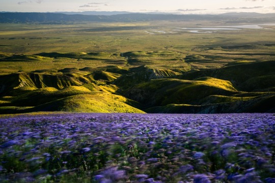
A long-exposure photograph shows a field of Phacelia flowers waving in the wind in the Temblor Range of the Carrizo Plain National Monument in 2017. © Provided by National Geographic
Why 2023 Could Be The Year of The Superbloom
An abundance of rain in California has set the stage for an epic “sea of flowers” this spring. Here’s how to see this increasingly rare phenomenon—responsibly.
A long-exposure photograph shows a field of Phacelia flowers waving in the wind in the Temblor Range of the Carrizo Plain National Monument in 2017.
— Photographs By Justin Benttinen | January 18, 2023 | By Alejandra Borunda
“Superblooms” of California and the U.S. Southwest are the stuff of (literal) legend. For centuries, Indigenous communities have celebrated massive springtime blossomings of chia, desert lilies, tarweeds, sunflowers, and other flowers with edible seeds or roots. “Fields as verdant as they are flower-covered touch the very waters of the sea,” wrote Spanish colonist Juan Bautista de Anza in 1774.
Today, these floral explosions are confined to pockets of relatively undisturbed habitats, mostly in the vast southwestern deserts of California, Arizona, and Nevada, and pop up only after a good rain year—an increasingly rare event in an era of climate change.

Flowers in the Phacelia genus, desert candle, and California goldfields drape the hillsides of Carrizo Plain National Monument during the 2019 bloom.

Of the 200 species of Phacelia wildflowers, California is home to 90—making it especially diverse.
This winter, California has seen an abundance—and in some cases overabundance—of rain, which has fallen relatively consistently since late autumn. That’s setting the stage for an excellent bloom, says Abby Wines, a ranger at Death Valley National Park in southern California—though it’s too early to tell if it will be on par with the legendary 2005 bloom, or even the 2017 or 2019 ones.
“It may or may not end up being a superbloom,” a term which has no technical definition and was coined sometime in the 1990s, she says. “But we’re predicting a well-above average bloom.”
But the glorious natural events are under threat—from hundreds of thousands of flower tourists who sometimes trample delicate blooms and soil; invasive species; ongoing development; and climate change, which is already making the region drier and hotter.
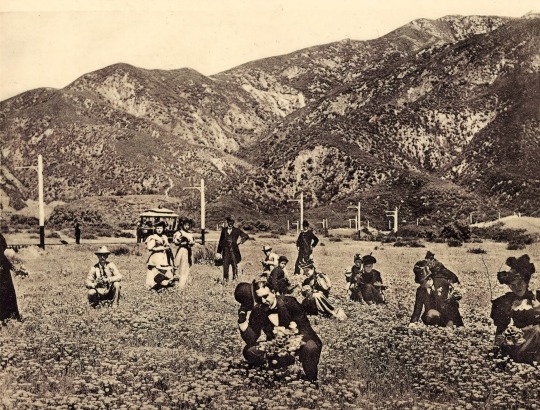
Angelenos used to take trams to Pasadena and Altadena to frolic in fields of poppies, as seen in this 1903 photograph. Photograph By Sepia Times/Universal Images Group Via Getty Images

Californians bragged about their breathtaking flower displays, which graced the cover of this 1935 postcard. Photo By Smith Collection/GADO/Getty Images
Spectacular Superblooms of the Past
Springtime annual wildflower blooms have happened for at least tens of thousands of years, driven in large part by fickle winter rains that would in some years bathe the California landscape from about December through February.
In the distant past, these blooms were often excellent—and enormous. Early Spanish colonizers described years when late winter-blooming native wildflowers stretched along coastal prairies and up narrow canyons, from what’s now the southernmost tip of California all the way up to the Bay Area, through the Central Valley and Sierra foothills, and beyond. After tribal communities collected the abundant edible seeds, they often burned fields intentionally—a strategy that likely encouraged consistent flower regrowth. John Muir described the Central Valley as an “inland sea” lined with blue flowers.
Even through the early 20th century, blooms persisted even in heavily populated Los Angeles County. After a good winter, the San Pasqual hills near Pasadena would glow with poppies: Angelenos hopped on trolleys en masse to the see the flowers. In 1895, one giddy visitor told the Los Angeles Times “it is as if the brightest sunset clouds had dropped down and wrapped the hills in its mantle.” In 1929, a National Geographic writer gushed that “in the early spring, California dons her party dress… literally all outdoors become one vast garden of flowers, until it seems there is no end to the colorful panorama.”
But as development pushed farther out, and more landscapes were converted to agriculture, grazing, subdivisions, or as invasive plants outcompeted the slightly fussy native seedlings, many of California’s spring flower fields disappeared.
“It’s one of the tragedies of the superbloom,” says Naomi Fraga, a botanist at the California Botanic Garden. “L.A. had these extraordinary opportunities to enjoy nature in their city the way it had been.”
Today, seas of flowers emerge almost exclusively in state or national parks—and especially desert regions including Death Valley, Anza-Borrego, Joshua Tree, and the arid Carrizo Plain, where flowers’ emergence contrasts spectacularly with the subdued dry-phase landscapes.
Even in the driest drought, deserts aren’t wastelands, but a flower miracle waiting to happen, says Daniel Winkler, a USGS desert expert: The seeds that feed the blooms are always present in the soil by the billions, just waiting—sometimes for decades—for the right conditions.
“The abundance is always there,” says Evan Meyer, director of the native plant-focused Theodore Payne Foundation, and “each superbloom is seeding the future.”

Fiddlenecks thrive in the Carrizo Plain National Monument during the 2017 bloom.
Why Do Superblooms Happen—and What’s Threatened?
Their occurrence is still shrouded in botanical alchemy. There are a few basic ingredients: a good rain year, but one where rains come consistently over several months and not in a single deluge; cool nighttime temperatures; and a well-stocked seed bank. “The preparation for a superbloom isn’t a sprint, it’s a marathon,” says Justen Whittall, a plant biologist at Santa Clara University.
Historical observations—cobbled together from botanists, European explorers, and later newspaper reports—suggest these conditions have historically lined up every decade or so, often following a drought but during an El Niño year, when the U.S. West tends to receive more rainfall.
But climate change is reshaping some of those cues. Instead of smaller, recurring winter storms, precipitation is coming in record-breaking deluges, like the recent spate of atmospheric rivers that dumped a year’s worth of rain onto California in just a few weeks. And heat waves are now sweeping through in the winter, jumpstarting germination at the wrong time, or drying out delicate baby seedlings.
“That’s all making it harder on the native wildflowers,” says Fraga, while favoring introduced species such as Saharan mustard or oatgrass, which grow with impunity under the same conditions.
“I have a lot of respect for these [native] plants, but in some ways they’re kind of wimpy. They’re not strong competitors,” she says, making it even more important to treat them with care when they do bloom, so they can survive and dump their seeds back into the soil to germinate again in the future.
Superblooms also occur in other parts of the world—after all, wildflowers are everywhere. Whittall saw a spectacular South Africa bloom full of familiar-ish wildflowers, and even the rain-starved Atacama Desert occasionally bursts into flower.

A rainbow arches over the Carrizo Plain blooms during a light rain in 2017.
How Can You See Them—Responsibly?
Whether or not 2023 yields a superbloom, visiting spectacular flowers is a really excellent way “to get excited and start thinking about plants,” says Meyer.
The “fragile, special, and in some ways dwindling experiences” can inspire deep relationships with the landscapes around us, he says—and get people involved in protecting them for the next bloom, some 10 years away.
Meyer and others offered a few rules of thumb for being a responsible flower tourist.
First, consider heading to less-trafficked blooms. Anza-Borrego Desert State Park can get over 200,000 visitors during a good flower season, while 2017’s bloom in Joshua Tree National Park brought in more than 1.5 million people.
When you’re there, tread carefully, says Daniel Winkler, a desert biologist for the U.S. Geological Survey: Desert and arid landscapes don’t recover quickly, and “a footprint can last a decade.” So stay on-trail and try not to step in or among the flowers.
Learn before you go—stop at a ranger station, call a “wildflower hotline,” and learn about the vast array of different flowers you might encounter.
Plant your own poppy fields! “What if we brought these flowers back to urban landscapes?” asks Meyer. Convert your front yard, balcony, or whatever space you have into a native wildflower haven. Neat!


Top: Photo Credit: James W. Cornett, Ecological Consultants. Left: Photo Credit: Collin Barrows Right: Photo Credit: Collin Barrows
0 notes
Text
Wednesday, September 21, 2022
Pentagon opens sweeping review of clandestine psychological operations
(Washington Post) In response to a report released by independent internet researchers, the Pentagon has ordered an audit of all the U.S. military’s clandestine information warfare operations. The move comes after the White House and other Washington, D.C. agencies have voiced concerns about the military’s psychological online campaigns. According to a report, Twitter and Facebook have taken down over 150 fake personas and pages over the past three years, with some linked to the U.S. military. Many profiles were pretending to be average people speaking Arabic or Farsi, making claims that ranged from deceased Afghan refugees being returned from Iran with missing organs to anti-Russia narratives and information about Covid-19 originating from China. Unfortunately for the Pentagon, Facebook and Twitter easily caught the military’s phony accounts, going so far as to contact the Department of Defense to warn it about the takedowns. According to one official, Facebook’s director for global threat disruption told the Pentagon, “We know what DOD is doing. It violates our policies. We will enforce our policies” and so “DOD should knock it off.” An even worse look than being found out by Facebook? Most of the military’s super secret social media campaigns had zero social media clout. The “vast majority of posts and tweets” found in the report received “no more than a handful of likes or retweets.”
UN General Assembly Commences
(1440) Leaders from over 150 countries are gathering in New York City this week as the United Nations opens the 77th session of the General Assembly, its first fully in-person meeting since 2019. This year’s agenda is expected to be dominated by Russia’s war in Ukraine and its impact on the global food and energy supply; notably, top leaders from Russia, China, and India have opted out of attending. Ukraine’s embattled President Volodymyr Zelenskyy will deliver the only remote speech of the session.
On Anniversary of Hurricane Maria, Storm Leaves Puerto Rico in the Dark
(NYT) Hurricane Fiona deluged Puerto Rico with unrelenting rain and terrifying flash floods on Monday, forcing harrowing home rescues and making it difficult for power crews to reach many parts of the island. Now the island is once again in darkness, five years after Hurricane Maria inflicted more damage on Puerto Rico than any other disaster in recent history. While Fiona will be the direct culprit, Puerto Ricans will also blame years of power disruptions, the result of an agonizingly slow effort to finally give the island a stable grid. Hurricane Maria, a near-Category 5 storm, hit on Sept. 20, 2017, leaving about 3,000 dead and damaging 80 percent of the system. The last house was not reconnected to the system until nearly a year later. Hurricane Fiona, with far less ferocious winds, is the strongest storm to reach the island since. Its copious rains on Sunday and Monday—more than 30 inches in some areas in southern Puerto Rico and its central mountainous region—caused the island’s vast lattice of canals and creeks to swell, turned entire streets into muddy rivers and forced the rescues of more than 1,000 people. At least one person died, while operating a generator, while another death was recorded in the Dominican Republic. (AP) Hurricane Fiona blasted the Turks and Caicos Islands on Tuesday as a Category 3 storm after devastating Puerto Rico, where most people remained without electricity or running water and rescuers used heavy equipment to lift survivors to safety. The Hurricane Center said the storm was likely to strengthen into a Category 4 hurricane as it approaches Bermuda on Friday.
Powerful earthquake hits Mexico on fateful anniversary, killing at least 2
(Reuters) A magnitude 7.6 earthquake struck western Mexico on Monday on the anniversary of two devastating temblors, killing at least two people, damaging buildings, knocking out power and sending residents of Mexico City scrambling outside for safety. Two died in the Pacific port of Manzanillo, authorities said, one crushed by the facade of a department store while another was found dead at a mall. The quake hit shortly after 1 p.m. (1800 GMT) near Mexico’s west coast and close to Michoacan’s border with the state of Colima—where major port Manzanillo is located. Mexico City Mayor Claudia Sheinbaum said there were no immediate reports of major damage in the capital after the quake struck, which rumbled through Mexico on the same day as destructive earthquakes battered the country in 1985 and 2017.
Ukraine, using captured Russian tanks, firms up its lines
(AP) Ukraine is now deploying captured Russian tanks to solidify its gains in the northeast amid an ongoing counteroffensive, a Washington-based think tank said Tuesday, as Kyiv vowed to push further into territories occupied by Moscow. The Institute for the Study of War said that Ukraine had been using left-behind Russian T-72 tanks as it tries to push into the Russian-occupied region of Luhansk. “The initial panic of the counteroffensive led Russian troops to abandon higher-quality equipment in working order, rather than the more damaged equipment left behind by Russian forces retreating from Kyiv in April, further indicating the severity of the Russian rout,” the institute said.
One Big Problem for Ukraine Is Clear: Glass
(NYT) There was one topic of conversation among the women bundled up in front of a bombed-out building the other day as they waited in a long line at a humanitarian food truck, a nippy wind swirling around them. “When are you going to get your glass?” This is becoming a big problem in Ukraine. So many windows have been shattered by explosions—“millions of them,” one humanitarian official estimated—that there is a nationwide run on glass. In the towns and cities that the Russian military has pounded with earthshaking artillery barrages, nothing has been spared—not the high rises, not the schools, not the squat little cottages. Just on Monday, the shock waves from a powerful Russian missile that exploded more than 800 feet from a nuclear power plant in southern Ukraine blew out more than 100 of the plant’s windows. This is what has happened to countless people’s homes in the line of fire: They might have been spared a direct hit, but all their windows have been shattered. And winter is coming. Fast. No doubt that Ukraine is facing a host of crises within crises, but one of the most urgent is the scramble to get damaged homes ready for winter, and that is where the glass comes in.
An economically illiterate junta is running Myanmar into the ground
(Economist) Queues snake away from open-backed trucks that sell cooking oil on the streets of Yangon. Since July people in Myanmar’s commercial capital have stood for hours in the tropical heat and rain to buy discounted oil from wholesalers. At 3,000 kyats ($0.90) a kilo it costs about half what it would on the open market. That still makes oil almost 50% dearer than it was last year, before a military coup put Myanmar’s economy into a tailspin. Queues snake away from open-backed trucks that sell cooking oil on the streets of Yangon. Since July people in Myanmar’s commercial capital have stood for hours in the tropical heat and rain to buy discounted oil from wholesalers. At 3,000 kyats ($0.90) a kilo it costs about half what it would on the open market. That still makes oil almost 50% dearer than it was last year, before a military coup put Myanmar’s economy into a tailspin. Rather than take responsibility for the crisis, junta supremo General Min Aung Hlaing lectures the Burmese on the importance of a lean diet. But the economy is ailing, and the junta is facing unprecedented resistance from ethnic and pro-democracy guerrillas.
US-Taliban Hostage Swap
(1440) President Joe Biden announced the release of Mark Frerichs, a US prisoner held hostage for over two years in Afghanistan, as part of a prisoner swap for Bashir Noorzai, a Taliban drug lord serving a life sentence in federal prison. Frerichs, a 60-year-old Navy veteran, was first abducted from Kabul in 2020 after being lured to a fake business meeting while working as a civil engineering contractor. Frerichs, an Illinois native, had worked in the country for over a decade and is said to be in stable health. Noorzai was convicted in 2008 of directing a drug-trafficking operation and was a financier of the Taliban in the 1990s. The news comes just days after the president met with family members of Brittney Griner and Paul Whelan, Americans detained in Russia. More than 60 Americans are believed to be wrongfully detained worldwide, including at least one other American, Ivor Shearer, in Taliban custody.
Young Palestinians arm themselves for a new era of violent resistance
(Washington Post) Jenin Refugee Camp, West Bank—It is just after midnight. Young men gear up in black shirts and black face masks, tie ribbons with militant group insignia around their foreheads, and parade their weapons through the narrow streets. Israeli officials fear that the black-market AK-47s, pistols, Kalashnikovs and M16s on display in the Jenin refugee camp will be directed at Israelis during the Jewish holidays that begin next week, as they brace for a new chapter of violent Palestinian resistance. Expectations of the passing of Palestinian President Mahmoud Abbas—the deeply unpopular, heavy-smoking 86-year-old autocrat who is believed to be in ill health—have already sparked a bloodier social order in this occupied city. In Abbas’s wake, “there will be fauda”—“chaos” in Arabic—said Mohammad Sabbagh, head of the People’s Services Committee of the Jenin refugee camp. Thousands of young people in Jenin are on Israel’s terrorism watch list, making them ineligible for work permits in Israel that would allow them to make a living. And they have watched as Israeli raids have killed dozens of noncombatants in recent months, already making 2022 the deadliest year for Palestinians in the West Bank since 2015. Poverty and fury have made the camp a hotbed of militancy.
Church attendance
(Baptist Press) Americans experienced seismic changes over the past two years, including, for many, how they attend church. The biennial State of Theology study conducted by Lifeway Research found relative stability in some of the religious and cultural beliefs U.S. adults hold. After months of quarantines and social distancing, however, Americans increasingly believe worshiping apart from a church is as good as attending church services. In March 2020, as the COVID-19 pandemic was just beginning in the United States, 58 percent of Americans said worshipping alone or with one’s family was a valid replacement for regularly attending church, with 26 percent strongly agreeing. In 2022, 66 percent believe worshiping apart from a local congregation is as valid as worshiping with one, with 35 percent strongly agreeing.
Scientists have calculated how many ants are on Earth
(Washington Post) A new estimate for the total number of ants burrowing and buzzing on Earth comes to a whopping total of nearly 20 quadrillion individuals. That staggering sum—20,000,000,000,000,000, or 20,000 trillion—reveals ants’ astonishing ubiquity. In a paper released Monday by the Proceedings of the National Academy of Sciences, a group of scientists from the University of Hong Kong analyzed 489 studies and concluded that the total mass of ants on Earth weighs in at about 12 megatons. Put another way: If all the ants were plucked from the ground and put on a scale, they would outweigh all the wild birds and mammals put together. For every person, there are about 2.5 million ants. “It’s unimaginable,” Patrick Schultheiss, a lead author on the study who is now a researcher at the University of Würzburg in Germany.
0 notes
Photo
State 5, Day 6 - Sequoia National Park, California. Visited General Sherman, witnessed the devastating effects of wildfires first hand, introduced the family to @innout, passed through Fresno to say Goodbye to an old friend and Hello to new ones, drove through the stunning Temblor Range, and had dinner in San Luis Obispo. #TravelingfromAtoZ (at Sequoia National Park) https://www.instagram.com/p/Cel3vKIpQoG/?igshid=NGJjMDIxMWI=
0 notes
Photo

Goldfields and Hillside Daisies
#socal#carrizo plain#california#wildflowers#superbloom#temblor mountains#caliente range#temblor range#soda lake
42 notes
·
View notes
Photo
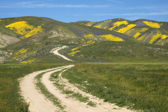
Road, Spring colors
Carrizo Plain and Temblor Range
#Flowers#Wildflowers#Mountains#Temblor Range#Temblor Mountains#Road#Dirt Road#Carrizo Plain#California#Scenery#Travel#Adventure#Landscape
3 notes
·
View notes
Text
u know how i laughed at cyberverse’s geological shenanigans? TFP has them too. I’m delighted to show u this “tectonic plate map” that got used in One Shall Rise pt.1:

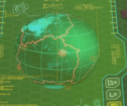
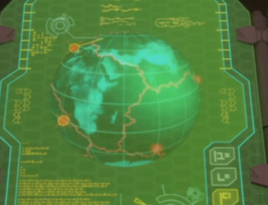
(if you know absolutely anything about plate tectonics u probably know those plate boundary lines are hilariously fucked up. let’s ignore those. here’s a better map for context.)
Mocking aside, let’s do some Analysis!
This map is showing the “seven quakes of the exact same magnitude at the exact same time” thing, early in Unicron’s brief wakeup. Let’s ID them.
off the screencap near Peru. I thought it was in the peruvian subduction zone but a later freezeframe bonus says the east pacific rise.
in the middle of the pacific ocean. thought this was the east pacific rise but that freezeframe says it’s literally in the middle of the plate lol.
down in fuckin antarctica?? nowhere near a plate boundary of any sort.
possibly the Banda sea plate, hard to tell due to map size/quality. which is actually a major seismic hazard zone, all sorts of plate boundaries here.
possibly the Kerguelen plateau? again, nowhere near a plate boundary.
middle of the south atlantic, possibly on the midocean ridge again.
off the coast of Portugal maybe? hard to tell bc of distortion. might be the midocean ridge again, might be one of the transform fracture zones, idk.
so that’s 3 intraplate settings, 3 extensional, and 1 of uncertain provenance. Intraplate does NOT mean no earthquakes (see. melbourne last month) but they do tend to be smaller and way less frequent. Earthquakes in extensional settings are more common, but also generally smaller. None of that means a heck of a lot when talking about the effect on communities - intensity of shaking is much more relevant than overall magnitude, and that has more to do with distance from the focus and underlying geology.
Agent Fowler describes the quakes as “Seven major temblors, of the exact same magnitude, at the exact same time as the eruption [of Megatron’s volcanic hotline to Unicron]. All over the globe, on different tectonic plates, in theory unrelated -- if they hadn’t happened at the exact same time.”
Few points here:
Aside from the ‘major earthquake’ part, this exact scenario is possible! Earthquakes and eruptions are constantly happening; the USGS estimates an average of about 55 per day, a number which is bound to rise as global seismic monitoring programs cover more areas of the globe.
Volcanoes also erupt all the fuckin time; the GVP thinks the global average is about 20-50 depending on whether you’re looking for activity or full on eruption. Timing is somewhat in question here, because eruptive events can last for a long damn time, certainly much longer than earthquakes.
3 and possibly 4 of the locations on the map are not very well covered by seismic monitoring networks, which makes determining magnitude etc. hard. Quakes also frequently get upgraded or downgraded over the days and weeks following the event, even in places with much better coverage. Fowler’s a little early to be making this proclamation.
It would be extremely Noteworthy to have seven major earthquakes occur on the same day regardless of magnitude! We can generally expect 1 quake of magnitude 8+ per year (3 so far in 2021, which is unusual but just a function of chance rly), and 15 or so in the 7-8 range. A quick wikipedia tally suggests the 6-7 range has a yearly total between 100-120.
'Major’ generally implies quakes of 7.0 or above, but I personally think 6.0+ can qualify under certain circumstances (coughintraplatesettingscough) and I think this would be one of them. :D
Conclusion: I think they got hit by 7 M6-ish quakes in a day, which would be enough to make scientists sit up and pay attention even without considering that 3 of the 7 happened in historically very seismically inactive areas. I could see media reports describing that as ‘at the same time’, lol. Locations suggest that probably only two of them caused any real damage (Banda sea and maybe Portugal). Seismologists and geophysicists are going absolutely nuts. Volcanologists are wondering why the heck Tolbachik suddenly turned purple.
#tfp#kem watches tfp#the TF geology tag#forgot what i tagged that shit as lol#volcanologists be like. someone pls distract those giant robots so we can grab a sample of the funky purple crystals pls???
37 notes
·
View notes
Photo

A long-exposure photograph shows a field of Phacelia flowers waving in the wind in the Temblor Range of the Carrizo Plain National Monument in 2017.
PHOTOGRAPHS BYJUSTIN BENTTINEN
#justin benttinen#photographer#long-exposure photograph#phacelia flower field#temblor range#carrizo plain national monument#landscape#nature#national geographic
20 notes
·
View notes
Text

HOMICIDE VIOLENCE STATS
In the National Strike between April 28 and May 8, 2021
47 PEOPLE KILLED (39 related to police violence)
963 ARBITRARY ARRESTS (According to records of Temblores NGO)
12 CASES OF SEXUAL VIOLENCE (All towards women)
548 DISSAPPEARED PEOPLE (Between May 28 and 7 Information given by the Defensoria del Pueblo)
28 VICTIMS OF EYE INJURIES (Between May 28 and 4 (11pm))
278 ASSAULTS BY THE POLICE (Between May 28 and 8 (6pm))
1,876 VIOLENT EVENTS (They could be more according to audiovisual records)

STATS ON MURDERS
Between April 28 and May 8, 2021
VICTIMS BY DEPARTMENT
Antioquia, Medellin: 1
Bogotá, Bogotá: 2
Cundinamarca, Soacha: 1
Cundinamarca, Madrid: 2
Risaralda, Pereira: 2
Risaralda, La Virginia: 1
Santander, Floridablanca: 1
Tolima, Ibagué: 1
Valle del Cauca, Cali: 35
Valle del Cauca, Yumbo: 1
VICTIMS PER DAY
April 28: 8
April 29: 3
April 30: 9
May 1: 6
May 2: 2
May 3: 10
May 4: 4
May 5: 0
May 6: 2
May 7: 3
VICTIMS BY AGE RANGE
4 minors
13 between 18 and 25 years old
12 between 26 and 36 years old
2 over 60 years old
16 unidentified
27 notes
·
View notes
Photo

Strong quake jolts islands in Kagoshima Prefecture | The Japan Times
A strong quake jolted the Tokara Islands chain in Kagoshima Prefecture on Thursday, but no tsunami warning was issued and there were no immediate reports of injuries or serious damage.
The magnitude-6.1 quake, which hit at around 11:05 a.m., measured upper 5 on the Japanese shindo seismic intensity scale of 7 on Akuseki Island, the Meteorological Agency said. The focus was at a depth of 14 kilometers, with the epicenter in waters near the Tokara Islands chain.
Municipal authorities said they have confirmed the safety of 64 residents and 12 visiting workers on Akuseki Island, situated more than 300 km from Kagoshima city on the main island of Kyushu.
The small island chain that falls within Kagoshima Prefecture has been hit by more than 240 earthquakes since Saturday — mostly minor shakes measuring 1 or 2 on the shindo scale.
The weather agency called for caution against more quakes of up to upper 5 on the shindo scale. But officials and experts say the quakes are not necessarily cause for alarm as they believe the series of quakes is a localized phenomenon.
The area saw a similar series of mostly minor quakes in April, when 265 temblors ranging from shindo 1 to 4 were observed.
Kyushu Railway Co. suspended Kyushu Shinkansen services for about 15 minutes following Thursday's quake due to a temporary blackout, but it resumed operations soon afterward.
3 notes
·
View notes
Photo
Jeff Pott Lupins, Looking Toward the Temblor Range, Carrizo Plain, Kern County, California 2019
24 notes
·
View notes
Photo
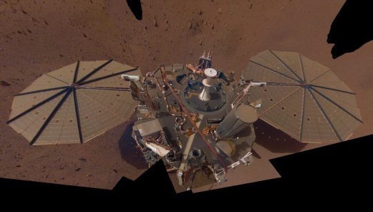
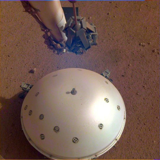
NASA’s InSight Finds Three Big Marsquakes, Thanks to Solar-Panel Dusting The lander cleared enough dust from one solar panel to keep its seismometer on through the summer, allowing scientists to study the three biggest quakes they’ve seen on Mars. On Sept. 18, NASA’s InSight lander celebrated its 1,000th Martian day, or sol, by measuring one of the biggest, longest-lasting marsquakes the mission has ever detected. The temblor is estimated to be about a magnitude 4.2 and shook for nearly an hour-and-a-half. This is the third major quake InSight has detected in a month: On Aug. 25, the mission’s seismometer detected two quakes of magnitudes 4.2 and 4.1. For comparison, a magnitude 4.2 quake has five times the energy of the mission’s previous record holder, a magnitude 3.7 quake detected in 2019. The mission studies seismic waves to learn more about Mars’ interior. The waves change as they travel through a planet’s crust, mantle, and core, providing scientists a way to peer deep below the surface. What they learn can shed light on how all rocky worlds form, including Earth and its Moon. The quakes might not have been detected at all had the mission not taken action earlier in the year, as Mars’ highly elliptical orbit took it farther from the Sun. Lower temperatures required the spacecraft to rely more on its heaters to keep warm; that, plus dust buildup on InSight’s solar panels, has reduced the lander’s power levels, requiring the mission to conserve energy by temporarily turning off certain instruments. The team managed to keep the seismometer on by taking a counterintuitive approach: They used InSight’s robotic arm to trickle sand near one solar panel in the hopes that, as wind gusts carried it across the panel, the granules would sweep off some of the dust. The plan worked, and over several dust-clearing activities, the team saw power levels remain fairly steady. Now that Mars is approaching the Sun once again, power is starting to inch back up. "Even after more than two years, Mars seems to have given us something new with these two quakes." Says InSight’s principal investigator, Bruce Banerdt “If we hadn’t acted quickly earlier this year, we might have missed out on some great science,” said InSight’s principal investigator, Bruce Banerdt of NASA’s Jet Propulsion Laboratory in Southern California, which leads the mission. “Even after more than two years, Mars seems to have given us something new with these two quakes, which have unique characteristics.” Temblor Insights While the Sept. 18 quake is still being studied, scientists already know more about the Aug. 25 quakes: The magnitude 4.2 event occurred about 5,280 miles (8,500 kilometers) from InSight – the most distant temblor the lander has detected so far. Scientists are working to pinpoint the source and which direction the seismic waves traveled, but they know the shaking occurred too far to have originated where InSight has detected almost all of its previous large quakes: Cerberus Fossae, a region roughly 1,000 miles (1,609 kilometers) away where lava may have flowed within the last few million years. One especially intriguing possibility is Valles Marineris, the epically long canyon system that scars the Martian equator. The approximate center of that canyon system is 6,027 miles (9,700 kilometers) from InSight. To the surprise of scientists, the Aug. 25 quakes were two different types, as well. The magnitude 4.2 quake was dominated by slow, low-frequency vibrations, while fast, high-frequency vibrations characterized the magnitude 4.1 quake. The magnitude 4.1 quake was also much closer to the lander – only about 575 miles (925 kilometers) away. That’s good news for seismologists: Recording different quakes from a range of distances and with different kinds of seismic waves provides more information about a planet’s inner structure. This summer, the mission’s scientists used previous marsquake data to detail the depth and thickness of the planet’s crust and mantle, plus the size of its molten core. Despite their differences, the two August quakes do have something in common other than being big: Both occurred during the day, the windiest – and, to a seismometer, noisiest – time on Mars. InSight’s seismometer usually finds marsquakes at night, when the planet cools off and winds are low. But the signals from these quakes were large enough to rise above any noise caused by wind. Looking ahead, the mission’s team is considering whether to perform more dust cleanings after Mars solar conjunction, when Earth and Mars are on opposite sides of the Sun. Because the Sun’s radiation can affect radio signals, interfering with communications, the team will stop issuing commands to the lander on Sept. 29, though the seismometer will continue to listen for quakes throughout conjunction. More About the Mission JPL manages InSight for NASA’s Science Mission Directorate. InSight is part of NASA's Discovery Program, managed by the agency’s Marshall Space Flight Center in Huntsville, Alabama. Lockheed Martin Space in Denver built the InSight spacecraft, including its cruise stage and lander, and supports spacecraft operations for the mission. A number of European partners, including France’s Centre National d‘Études Spatiales (CNES) and the German Aerospace Center (DLR), are supporting the InSight mission. CNES provided the Seismic Experiment for Interior Structure (SEIS) instrument to NASA, with the principal investigator at IPGP (Institut de Physique du Globe de Paris). Significant contributions for SEIS came from IPGP; the Max Planck Institute for Solar System Research (MPS) in Germany; the Swiss Federal Institute of Technology (ETH Zurich) in Switzerland; Imperial College London and Oxford University in the United Kingdom; and JPL. DLR provided the Heat Flow and Physical Properties Package (HP3) instrument, with significant contributions from the Space Research Center (CBK) of the Polish Academy of Sciences and Astronika in Poland. Spain’s Centro de Astrobiología (CAB) supplied the temperature and wind sensors. TOP IMAGE....This selfie of NASA’s InSight lander is a mosaic made up of 14 images taken on March 15 and April 11 – the 106th and 133rd Martian days, or sols, of the mission – by the spacecraft Instrument Deployment Camera located on its robotic arm. Credit: NASA/JPL-Caltech LOWER IMAGE....InSight’s domed Wind and Thermal Shield covers the lander’s seismometer, called Seismic Experiment for Interior Structure, or SEIS. The image was taken on the 110th Martian day, or sol, of the mission. Credit: NASA/JPL-Caltech
1 note
·
View note
Last Seen Blogs

guardian-of-storytelling
Guardians of Childhood

nanikaq
nanikaQ

tarrevizsla
here once was light

jackshiccup
existing just like this forever

avengerclasses
"The Passion Of Lovers Is For Death", Said She