#Alagalla
Text
𝐌𝐞𝐞𝐲𝐚𝐧 𝐄𝐥𝐥𝐚 𝐅𝐚𝐥𝐥𝐬 𝐒𝐫𝐢 𝐋𝐚𝐧𝐤𝐚
Many environmentalists, waterfall aficionados, and members of the general public in our nation are unaware of Meeyan Ella Falls. At the very least, few people even know where it is. This waterfall is situated close to the Ihalakotte train station along the Kandy railway line. Helan-Madiththa, a location on the Alagalla mountain, is the source of the stream that forms the Meeyan Ella waterfall. The waterfall's original course passed through the villages of Walagoda and Thalagolla before merging with Thalagolla Oya. It then fell as a single stream over a rock. The connection between Ma Oya in Boella and Thalagolla Oya follows.
However, the waterfall now divides into two segments with a 50-meter separation. A fascinating tale of how a large waterfall was once split into two smaller ones. To carry products, especially Ceylon tea from Kandy for export during the British Colonial Era, the Colonials built a railway line between Colombo and Kandy. The mid-1800s saw the construction of the railroad line between Polgahawela and Kandy. The Colonials at Alagalla had the difficult task of building the railway over the substantial waterfall Meeyan Ella. As a result, the Colonials were forced to complete the enormous task of digging a tunnel through the Alagalla rock, which was around 304 meters (1000 ft) deep. Instead, they looked for other options, and after examining the location, they came to the conclusion that the only choice was to obstruct the cascade upstream and carve two significant grooves into the rock. As a result, instead of one large waterfall, the water would cascade into two smaller ones. After the job was finished, a horizontal cut through the Alagalla rock measuring about 426 meters (1400 feet) long and five meters (18 feet) deep was made in order to build the railway line, which was finished up to Kandy in 1867. This groove was unable to handle the tremendous rush of water in the stream during severe downpours, and the railway was repeatedly carried away. Due to their difficulty pronouncing "Meeyan Ella," the British Colonials dubbed the waterfall "Meen Galla."
𝗥𝗲𝗮𝗱 𝗠𝗼𝗿𝗲:
𝗚𝗼𝗼𝗴𝗹𝗲 𝗠𝗮𝗽:
#MeeyanEllaFallsSriLanka#IhalakotteTrainStation#Kegalle#Kandy#Alagalla#WaterfallHunting#MistyMountains#waterfallSriLanka#Hiking#Viewpoint#travel#travelsrilanka#travelphotography#srilanka#srilankatravel#srilankatrip#srilankatourism#ceylon#paradiseisland#destination#nature#naturelover#waterfalls#VisitSriLanka#BeautifulplacesSriLanka#PlacestoVisitSriLanka#Travelisland#Hillcountry#WaterfallAdventure#CampingPlacesSriLanka
0 notes
Photo

Hello-hello... Do you wanna some wild and wierd Alagalla staff?
Well how about... A dog-wife!? Alagadda wouldn't be a full-fledged citadel of debauchery and decadence without its own furry hangout!.. Well, it's not furries - it's chimeras. Two or more bodies fused into one and raised by the power of the Hanged King.
Meet the inhabitant of Alagadda and the servant of the Red Lord, half a woman, half a dog - Guzelit, a rare phenomenon even for Alagadda.
***
At the court of the Wearer of the Mirthful Mask, Guzelit has two positions at once. The first is quite expected - a simple concubine, basking in luxury and excess. But the second position is a consequence of the fact that her mongrel soul (although there is as much of a real dog in her as there are grapes in Alagadda’s wine - and then it's time to remember that it is made from a different kind of juices) gets tired of the monotony of a well-fed life too quickly. Usually the servants of the Red Lord are faceless, and lead an unremarkable existence full of excesses, but if you meet a Guzelit, you will definitely remember her, and not only because of her outstanding appearance. She is charming, sharp-tongued and playful - It is her job to amuse the Lord and his guests at receptions and feasts held by him, and she always has the latest and most interesting rumors, stories and jokes in store. She is a parasite, an heiress of the ancient Roman and Greek profession.
Parasites were men who were specially invited to feasts and celebrations for a fee to entertain guests and hosts with conversations and stories. For Guzelit, this is a good way to see as many new faces and stock up as many fresh rumors as possible to tell them at another feast.
Such a stormy life, filled with passions of all kinds, brings her pleasure. In any company, she becomes a welcome guest, and in any environment finds a place under the sun. However, her ability to blend into any society made her almost insensitive to someone else's grief. She cares little about the fate of other servants or her lovers, and sometimes she crosses the line even with her close friend – the servant of the Yellow Lord named Asmodir. Therefore, if you meet a charming chimera in a hat with feathers – be careful. No one knows what her flighty Lord will demand of her this time.
More interesting facts:
1. All chimera residents have more than one mask on their body. For Guzelit, such is attached to the back of her head – and she hides it behind the fabric of the headdress.
2. On her hat you can notice the figure of a sparrow – an ancient symbol of fertility, dexterity, cunning and... harlots. Lol.
3. In my interpretation, the abode of the Red Lord is called Mercurian Towers of the Winged Lion. And the statue that Guzilit leaned on is a reference to who she serves.
4. Chimeras prefer to stick together. Really like a little furry party...
5. And the head of all furries is the Yellow Lord! Almost all of Alagadda's chimeras eventually become his subordinates, to the envy and bewilderment of the other Lords. Chimera is a rare and desirable acquisition for them. But for some reason, only Citrinitas is surrounded by a lil Alagalla’s mess up menagerie... He-he-he!
#SCP Foundation#Alagadda#alagadda oc#SCP art#scp 2264#OC#scp#scp fandom#scp fanart#traditional art#grimdark#light body horror#body horror#scp oc#my post#my art
35 notes
·
View notes
Text

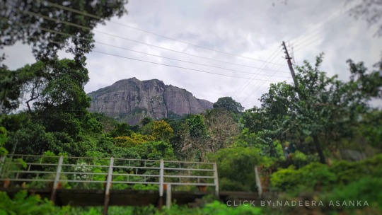
Alagalla Mountain Range - Mawanella , SriLanka
photo credit @_.sixfoothiker._
2 notes
·
View notes
Photo

🌻❤ . . . . . . . .. . . . . . . #alagalla #tripadvisor #traveldiary #traveltricks #travelpath #traveltheworld #travelphotography #travel_with_us #nurture #enjoylife #husbandandwife #travelwithwife #withmywifey❤️ #hansiandharsh #hiking #camping #srilankan #travelgram #celontravel #celonese #repost #flowers (at Alagalla Mountain Range) https://www.instagram.com/p/CHEtolxHdEx/?igshid=agrw68rdc6it
#alagalla#tripadvisor#traveldiary#traveltricks#travelpath#traveltheworld#travelphotography#travel_with_us#nurture#enjoylife#husbandandwife#travelwithwife#withmywifey❤️#hansiandharsh#hiking#camping#srilankan#travelgram#celontravel#celonese#repost#flowers
0 notes
Photo
අලගල්ල කන්ද ඉහල කෝට්ටේ දුම්රිය ඉස්ථානයේදී....... #අලගල්ල #ඉහලකෝට්ටේ #green_island_sl #naturephotography #naturelover #phonephotography #alagalla #ihalakootte #Wonderful #wonderful_places #Ceylon #srilankan #srilankannature #srilankanbeauty #sri #skyphotography (at ඉහලකොට්ටෙ) https://www.instagram.com/p/CDHRCvPB8gx/?igshid=7p0j9tgg6tke
#අලගල#ඉහලක#green_island_sl#naturephotography#naturelover#phonephotography#alagalla#ihalakootte#wonderful#wonderful_places#ceylon#srilankan#srilankannature#srilankanbeauty#sri#skyphotography
0 notes
Text
Ambuluwawa Mountain in Sri Lanka 🇱🇰 🇱🇰 🇱🇰 ..........
From Gampola town take the Hemmatagama road for about 5 km to reach the Ambuluwawa hill access road.
Situated on an area of about 927 acres, this hill is isolated from other mountain ranges.
Due to the Chaitya located on the hill at a height of 3567 feet above sea level, this place has become a unique place.
This dagoba can be easily seen from Gampola town.
It is possible to walk from the foot of the mountain. It is also possible to inject in a vehicle up to the base of the dagoba.
Most people cross this entire distance on foot to have an amazing experience.
Mountaineers do not feel tired because of the cool breeze and the shade of the tree-lined road.
A Catholic church, a Hindu temple, a mosque and a Buddhist temple have been built on the top of the hill to accommodate people of different faiths.
This stupa which was built to mark agriculture is called Govijana Seya.
There is a Buddha statue at the end of the road and statues of gods and goddesses have been created in the rooms from there.
The stone Buddha statue in the temple, which was built on a flat ground on a hill, shows the skill of the present day carpenter.
A Bo tree which originated from the Eastern branch of the Sri Maha Bodhi tree in Anuradhapura is also perched on the top of the hill.
Overcoming all this, the 400 feet high Govijana Seya is a unique one.
You must go to the top of the stupa to experience an incredible adventure.
The uniqueness of the stupa is the stairs that lead to its top.
Part of it should go through the dagoba and the rest from the outside. For maximum enjoyment, the entire trek should take place outside the Chaitya.
Gradually the narrow staircase ends by closing the gap between the dagoba wall and the handrail.
During the last few steps, you can enter the stalls and switch from top to bottom and from bottom to top.
This should be done very carefully as the stairs are windy.
From here you can see 360 degrees without any obstacles from any mountain.
On a clear day, even the ocean is visible to the naked eye.
In the distance Sacred Butterfly Mountain, Namunukula, Knuckles Mountains, Hanthana, Batalegala, Pidurutalagala, Alagalla, Moneragala, Rakshawa, Saptha Kanya, Hunnasgiriya, Bhairava Kanda, Utuwankanda, Balapokuna, Kalugala, Muloya, Peopi, Ahupini, Ahupini, Ahupini Mountains as well as a number of mountain systems not mentioned here can be closely observed.
It is home to endemic species as well as a rich biodiversity.
Launched in 1997, the historic mountain was selected by the United Nations in 2002 as the World's Best Developed Mountain and opened to the public on September 18, 2007.
The city of Gampola, the city of Kandy and the Mahaweli river that flows through it create a spectacular view ...

2 notes
·
View notes
Video
Hiking and camping experience to Alagalla mountain range. Enjoy the full video on “Greenfolks” YouTube channel. Link is in my bio. If you like to watch more of our videos, subscribe our channel and hit the bell button to turn on the notifications. . . . . Follow us @go_flysmart_holidays_pvt_ltd . . . . . #go_flysmart_holidays #go_flysmart_holidays_pvt_ltd #greenfolks #harith_sankalpa #srilankatravel #srilankavlog #srilanka #sosrilanka #exploresrilanka #beautifuldestinations #earthoutdoors #earthpix #dronephotography #srilankaphotographer #srilankavideographer #travelvlogger #alagalla #hikinglife #mountains
#go_flysmart_holidays#go_flysmart_holidays_pvt_ltd#greenfolks#harith_sankalpa#srilankatravel#srilankavlog#srilanka#sosrilanka#exploresrilanka#beautifuldestinations#earthoutdoors#earthpix#dronephotography#srilankaphotographer#srilankavideographer#travelvlogger#alagalla#hikinglife#hikingadventures#mountains
0 notes
Photo

Rain and long weekend. #Alagalla #holidays (at Alagalla Mountain Range)
0 notes
Photo

When the moment you see a cliff on a peak, totally going mad 😡 😡 😡!!! You call it #adventure !!! #adrinalinejunkie #travellife #risktaker #travelgram #travelwithDK #adventurethatislife #hiking #hikingadventure #Alagalla #poojagala #visitSrilanka #exploresrilanka #extremehiking #crazytimes Photo Credits to @_not_no_1 (at Alagalla, Sri Lanka)
#visitsrilanka#adventure#adrinalinejunkie#travelwithdk#risktaker#exploresrilanka#alagalla#adventurethatislife#travellife#hikingadventure#hiking#poojagala#crazytimes#travelgram#extremehiking
0 notes
Photo

Wow 😍 That breathtaking view. Alagalla and Ambuluwawa mountains are there. #sightseeing #ceylontea #mointains #traveller #love #beautifuldestinations #traveladdict #travellife #traveling #travelgram #wanderer #nomads #natgeo #travelblogger #instatravel #wanderlust #travelphoto #travelpic #wonderful #beautiful #nature #culture #enjoy #relax #travel #letsgo #explore #srilanka #helloceylon Travel With Us @helloceylon (at Dolosbage, Sri Lanka) https://www.instagram.com/p/B0yYXCOBpQD/?igshid=lpdhkb9l9r11
#sightseeing#ceylontea#mointains#traveller#love#beautifuldestinations#traveladdict#travellife#traveling#travelgram#wanderer#nomads#natgeo#travelblogger#instatravel#wanderlust#travelphoto#travelpic#wonderful#beautiful#nature#culture#enjoy#relax#travel#letsgo#explore#srilanka#helloceylon
1 note
·
View note
Photo

💚😊 • • • • • Credits 📷 @_pavva_ @varunaabeyratne Follow @ceylon_campers 🇱🇰 🔺🔺🔺🔺🔺🔺🔺🔺🔺🔺🔺 Tag #ceyloncampers in your best camping memmories - - - - #instacamping #campingworld #visitsrilanka #srilanka #srilankatravelgram #campingsrilanka #srilankatourism #exploresrilanka #ceylontraveldiary #instatravel #travelstagram #ceylontravel #beautyofsrilanka #ceylondiaries #travelsrilanka🇱🇰 #campinglife⛺️ #camping⛺️ #bushcraft #roamceylon #travelsrilanka #ilovesrilanka 📸 (at Alagalla Mountain Range) https://www.instagram.com/p/CWGAxXzIJ_g/?utm_medium=tumblr
#ceyloncampers#instacamping#campingworld#visitsrilanka#srilanka#srilankatravelgram#campingsrilanka#srilankatourism#exploresrilanka#ceylontraveldiary#instatravel#travelstagram#ceylontravel#beautyofsrilanka#ceylondiaries#travelsrilanka🇱🇰#campinglife⛺️#camping⛺️#bushcraft#roamceylon#travelsrilanka#ilovesrilanka
0 notes
Text
𝐌𝐞𝐞𝐲𝐚𝐧 𝐄𝐥𝐥𝐚 𝐅𝐚𝐥𝐥𝐬 𝐒𝐫𝐢 𝐋𝐚𝐧𝐤𝐚

Many environmentalists, waterfall aficionados, and members of the general public in our nation are unaware of Meeyan Ella Falls. At the very least, few people even know where it is. This waterfall is situated close to the Ihalakotte train station along the Kandy railway line. Helan-Madiththa, a location on the Alagalla mountain, is the source of the stream that forms the Meeyan Ella waterfall. The waterfall's original course passed through the villages of Walagoda and Thalagolla before merging with Thalagolla Oya. It then fell as a single stream over a rock. The connection between Ma Oya in Boella and Thalagolla Oya follows.
However, the waterfall now divides into two segments with a 50-meter separation. A fascinating tale of how a large waterfall was once split into two smaller ones. To carry products, especially Ceylon tea from Kandy for export during the British Colonial Era, the Colonials built a railway line between Colombo and Kandy. The mid-1800s saw the construction of the railroad line between Polgahawela and Kandy. The Colonials at Alagalla had the difficult task of building the railway over the substantial waterfall Meeyan Ella. As a result, the Colonials were forced to complete the enormous task of digging a tunnel through the Alagalla rock, which was around 304 meters (1000 ft) deep. Instead, they looked for other options, and after examining the location, they came to the conclusion that the only choice was to obstruct the cascade upstream and carve two significant grooves into the rock. As a result, instead of one large waterfall, the water would cascade into two smaller ones. After the job was finished, a horizontal cut through the Alagalla rock measuring about 426 meters (1400 feet) long and five meters (18 feet) deep was made in order to build the railway line, which was finished up to Kandy in 1867. This groove was unable to handle the tremendous rush of water in the stream during severe downpours, and the railway was repeatedly carried away. Due to their difficulty pronouncing "Meeyan Ella," the British Colonials dubbed the waterfall "Meen Galla."
𝗥𝗲𝗮𝗱 𝗠𝗼𝗿𝗲:
𝗚𝗼𝗼𝗴𝗹𝗲 𝗠𝗮𝗽:
#MeeyanEllaFallsSriLanka#IhalakotteTrainStation#Kegalle#Kandy#Alagalla#WaterfallHunting#MistyMountains#waterfallSriLanka#Hiking#Viewpoint#travel#travelsrilanka#travelphotography#srilanka#srilankatravel#srilankatrip#srilankatourism#ceylon#paradiseisland#destination#nature#naturelover#waterfalls#VisitSriLanka#BeautifulplacesSriLanka#PlacestoVisitSriLanka#Travelisland#Hillcountry#WaterfallAdventure#CampingPlacesSriLanka
0 notes
Text

Alagalla Mountain Range - Mawanella , SriLanka
photo credit @__t_i_s_h_a_n__
2 notes
·
View notes
Photo

Life is short, and the world is wide. (at Alagalla Mountain - Sri Lanka) https://www.instagram.com/p/CKK36oIHinK/?igshid=1c0h5asczyrco
0 notes
Photo

Repost: @mawanella.sl Hikers dream Alagalla Mountain Range #Mawanella 📷 @chathushka_nirman #Hike #Trekking #adventure #nature #mountain #srilanka http://ift.tt/2khSFwH
1 note
·
View note
Photo

Katusukonda, Hanthana Mountain Range, Kandy . 📸 Photo courtesy by @_thesailor This place probably has one of the best 360 views in whole srilanka.. 😎😍 . . End of the hanthana mountain range is the “Katusukonda”. It is known as Katusukonda because that area of the mountain range looks like a back of a lizard. During the hikes to each peak, you’ll have to cross thick forest patches and Mana bushes.(wear long sleeves) It is an eye-catching scenic view on top of Hanthana range. Sitting on top of Hanthana, on one side right within your sight, you can see Peacock hills, Gampola town, Kabaragala- the highest peak of Dolosbage mountain, Kadugannawa, Alagalla, Mahaweli River, Bathalegala, and Piduruthalagala Mountain. On the other side Knuckles range, Hunnasgiriya, Wilshire, and Etipola will create a scenic picture..🙏🏽💚 Dont forget to carry enough water if you hike up here.. 😎😉 💦 (Reposted) (at Hanthana Mountain Range) https://www.instagram.com/p/B4FDPglBpw5/?igshid=19791wd9y3tsa
0 notes
Last Seen Blogs

subbooy
İtaatkar/Submissive

thelilwickedninja
Untitled

spaghoe-blog
Whore

judexxduarte
𝓣𝓱𝓮 𝓒𝓻𝓾𝓮𝓵 𝓟𝓻𝓲𝓷𝓬𝓮

ourweepingcollectionthinglo-blog
Untitled