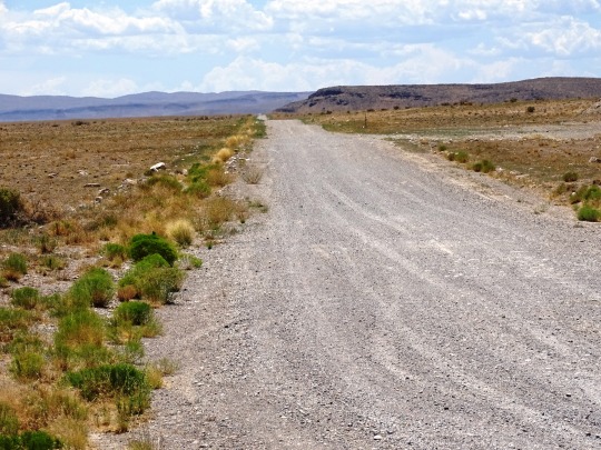
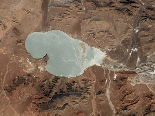
#endorheic lake
Text
Who can recognize what part of the earth we are looking at?
Video by Roscosmos cosmonaut (Russia): Oleg Artemiev
Music: FREE FLOW FLAVA - FUJI
#endorheic lake#Kyrgyzstan#озеро#ИссыкКуль#Киргизия#Кыргызстан#вода#IssykKul#lake#water#небо#арт#Земля#планета#sky#art#Earth#planet#космос#космонавт#МКС#iss#space#ОлегАртемьев#olegmks#Роскосмос#spaceart#travel#traveling#reels
80 notes
·
View notes
Text
Hey All,
I've been away for some time, as we've been working really hard on something quite exciting:
let me present to you the world's first ever global ocean drainage basin map that shows all permanent and temporary water flows on the planet.

This is quite big news, as far as I know this has never been done before. There are hundreds of hours of work in it (with the data + manual work as well) and it's quite a relief that they are all finished now.
But what is an ocean drainage basin map, I hear most of you asking? A couple of years ago I tried to find a map that shows which ocean does each of the world's rivers end up in. I was a bit surprised to see there is no map like that, so I just decided I'll make it myself - as usual :) Well, after realizing all the technical difficulties, I wasn't so surprised any more that it didn't exist. So yeah, it was quite a challenge but I am very happy with the result.
In addition to the global map I've created a set of 43 maps for different countries, states and continents, four versions for each: maps with white and black background, and a version for both with coloured oceans (aka polygons). Here's the global map with polygons:
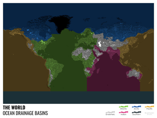
I know from experience that maps can be great conversation starters, and I aim to make maps that are visually striking and can effectively deliver a message. With these ocean drainage basin maps the most important part was to make them easily understandable, so after you have seen one, the others all become effortless to interpret as well. Let me know how I did, I really appreciate any and all kinds of feedback.
Here are a few more from the set, I hope you too learn something new from them. I certainly did, and I am a geographer.
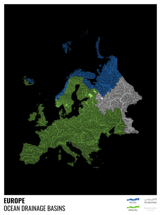
The greatest surprise with Europe is that its biggest river is all grey, as the Volga flows into the Caspian sea, therefore its basin counts as endorheic.
An endorheic basin is one which never reaches the ocean, mostly because it dries out in desert areas or ends up in lakes with no outflow. The biggest endorheic basin is the Caspian’s, but the area of the Great Basin in the US is also a good example of endorheic basins.
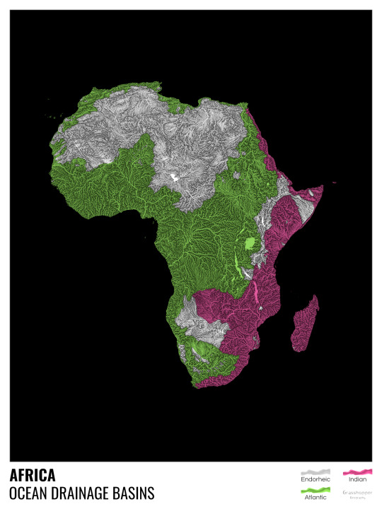
I love how the green of the Atlantic Ocean tangles together in the middle.
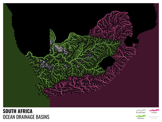
No, the dividing line is not at Cape Town, unfortunately.
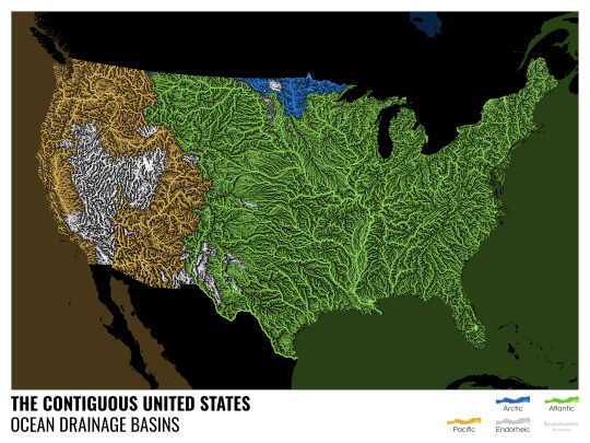
I know these two colours weren’t the best choice for colourblind people and I sincerely apologize for that. I’ve been planning to make colourblind-friendly versions of my maps for ages now – still not sure when I get there, but I want you to know that it’s just moved up on my todo-list. A lot further up.
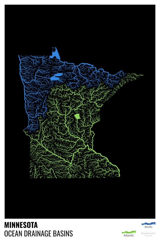
Minnesota is quite crazy with all that blue, right? Some other US states that are equally mind-blowing: North Dakota, New Mexico, Colorado, Wyoming. You can check them all out here.
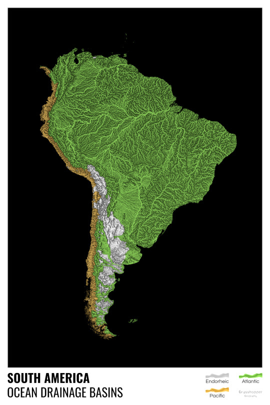
Yes, most of the Peruvian waters drain into the Atlantic Ocean. Here are the maps of Peru, if you want to take a closer look.
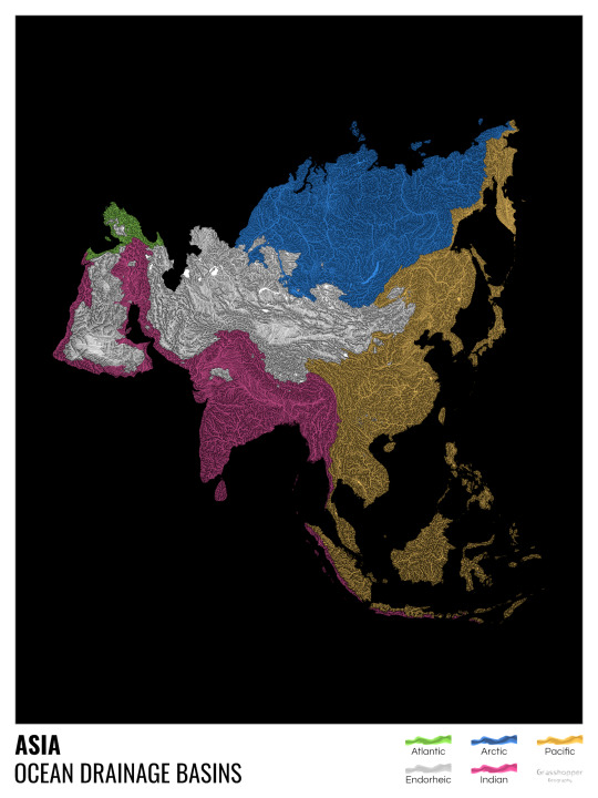
Asia is amazingly colourful with lots of endorheic basins in the middle areas: deserts, the Himalayas and the Caspian sea are to blame. Also note how the Indonesian islands of Java and Sumatra are divided.
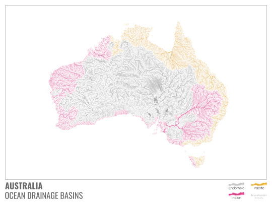
I mentioned earlier that I also made white versions of all maps. Here’s Australia with its vast deserts. If you're wondering about the weird lines in the middle: that’s the Simpson desert with its famous parallel sand dunes.
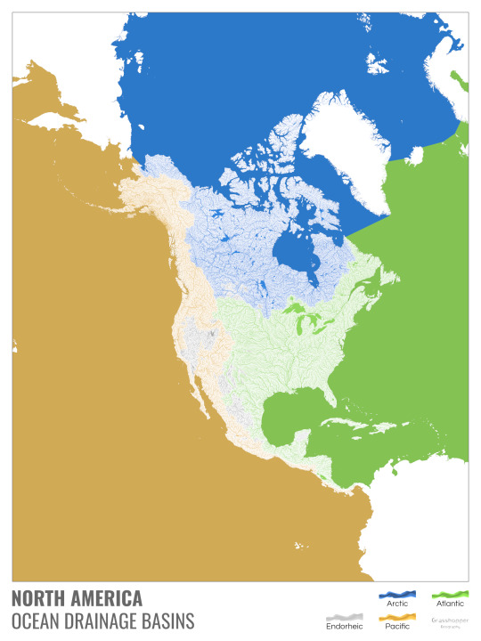
North America with white background and colourful oceans looks pretty neat, I think.

Finally, I made the drainage basin maps of the individual oceans: The Atlantic, the Arctic, the Indian and the Pacific. The Arctic is my favourite one.
I really hope you like my new maps, and that they will become as popular as my river basin maps. Those have already helped dozens of environmental NGOs to illustrate their important messages all around the world. It would be nice if these maps too could find their purpose.
#maps reimagined#geography#cartography#maps#my art#rivers of the world#ocean drainage basins#ocean maps#river maps
16K notes
·
View notes
Text
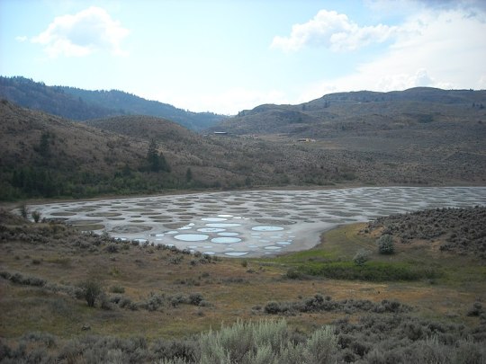
The Spotted Lake from the shoulder of Highway 3. It is a saline endorheic alkali lake located northwest of Osoyoos in the eastern Similkameen Valley of British Columbia, Canada.
57 notes
·
View notes
Text
Toshka Lakes is a group of recently formed endorheic lakes in the Sahara Desert of Egypt. They began to emerge in late 1998 as excess water from Lake Nasser overflowed, filling a nearby limestone valley. The rise and fall of the lakes over the past two decades has depended on fluctuations in the flow of the Nile River — in 2012 they had almost dried up, but began to fill once again by 2019.
23.100000°, 30.900000°
Source imagery: Planet
110 notes
·
View notes
Text
Submitted via Google Form:
How big can a desert oasis be? I know the Nile river delta is massive but how much bigger can it get? I'd like to have one half the area of Egypt. What also needs to be done about the rivers that flow into them?
Tex: An oasis has a geological underpinning that is man-made in its longevity (Wikipedia), so I suppose they’re only as large as they need to be. Some factors in that include amount of irrigation, size of the underlying water table, how long you can travel from one oasis to another before running out of water, and mode of transportation that typically dictates rate of travel.
By definition, an oasis resides in a desert. If something is large enough to cover, as you say, half of Egypt, then the resulting changes in the local environment might create a temperate climate rather than an arid one. Rivers are part and parcel with sedimentary or metamorphic rocks because of its more porous nature than igneous rock, and are the surface-visible part of water movement that also works underground through things like water tables/aquifers.
Licorice: Apparently the largest oasis in our world is 33 square miles. It has four cities and 22 villages. It's in Saudi Arabia and it's called Al-Ahsa. Al-Ahsa_Oasis (Wiki)
I think it might all be a question of scale. An oasis half the size of Egypt wouldn’t be an oasis in the Sahara desert, but if your desert took up half your planet, then that huge oasis might be considered an oasis.
Utuabzu: The exact definition of oasis gets a little fuzzy, since it’s not super clear at what point your lake becomes an inland sea. But an oasis is typically a body of water formed by upwelling groundwater - generally from an artesian basin of some kind - in an otherwise arid environment. They can range in size from a glorified puddle to the one Licorice mentioned, and they’re not necessarily permanent features on the landscape. Plenty of oases are seasonal, only present when the groundwater has risen due to rains elsewhere and vanishing again once the water table drops.
You mentioned the Nile Delta, which is not an oasis. I suspect you may have meant the Fayum, which is a body of water formed by a branch of the Nile entering an endorheic basin - a watershed that cannot empty to the sea because it is too high on all sides - and has been and remains a very agriculturally productive region of Egypt. Endorheic basins can also produce what are called inland deltas, where a river fans out into a large wetland at the bottom of the basin, as it is unable to reach the sea and does not have high enough water flow to flood the basin and create a lake or inland sea. Examples of this include the Okavango Delta in Botswana and the Sistan Delta in Iran and Afghanistan. More commonly endorheic basins have lakes (often salt lakes) or saltpans at their lowest points, and small or intermittent to non-existent waterways.
If we take what you want to be a region approximately the size of Egypt with a river that ends in a delta but does not flow into the sea, surrounded by desert, then that is possible. The Syr Darya and Amu Darya rivers flow through the Central Asian deserts and steppe to empty into the Aral Sea, which is an endorheic basin that once housed an enormous freshwater lake.* The region between these two rivers - called Transoxiana in classical sources - has been home to a chain of vibrant, prosperous civilisations and a vast diversity of peoples and cultures. So if you want to have a big river run through a desert and empty either into a lake or an inland delta, so long as you know where the water is coming from - the Syr Darya and Amu Darya are fed by snowmelt from the Hindu Kush and Tian Shan mountains, while the White Nile, which is the source of the Nile floods, rises in the Ethiopian Highlands and is fed by the wet season rains there - then there’s really no reason why you shouldn’t. Far stranger things exist in real life.
*Soviet hydroengineering has resulted in the Aral Sea all but drying up, causing immense ecological damage to Central Asia.
14 notes
·
View notes
Note
hey little water boy I feel like you would have something wonderful to say about The Great Salt Lake of Utah
I don't know a whole lot about the Great Salt Lake, but I do find it compelling! The following is things that stood out to me learning about it just now:
It's endorheic, meaning it is the point to which all water in the watershed goes. The watershed is a closed system; instead of flowing into another one or into the ocean a la most watersheds, it is like a bowl. A sink. Water has no choice but to go to the Great Salt Lake, where it will slowly percolate down into the local groundwater system or evaporate.
And that's why it's salty. Pretty much all endorheic lakes are. Those solutes, all the salts normally present in minute concentrations in freshwater, cannot go up into the atmosphere alongside water vapor after it evaporates. It's left behind. Even when going down into the water table, they get left behind a bit. So; it's salty, it's getting saltier, infinitely. Due to the shape of the basin, water will probably always flow there, but eventually the salt and sediment will build up enough that it won't be the lowest point and then maybe we will have the Great Salt Lake To The Left.
Ecologically it's interesting. Since it's cut off from the ocean, intrusion of traditionally saline species is unlikely, to say the least. But it has tons of wetlands, which support tons of migratory birds. There's some fish where freshwater contributes most directly, but the number is few and range is restricted enough that brine shrimp flourish.
There is a manmade causeway separating the lake into north and south sections with differing elevations, resulting in stratification and different algal regimes. The south is cyanobacteria dominant and even has stromalites! That's so cool! Stromalites were common in the world's original oceans. In the north, there's the common pink orange water dyeing friend Dunaliella, who is Rich In Beta Carotene. What's really neat/funny to me about this is this is basically the same set up that flamingos flourish in, since most are somewhat like extremophiles and are designed for living in endorheic lakes dominated by brine shrimp and Dunaliella. But they're natively elsewhere. But basically, you could totally have invasive flamingos in Utah if someone fucked up just a bit. Though, the brine shrimp are only transient in the north side of the lake; the north side also contributes to an underlying brine layer, so really it sounds like most life is probably on the south end.
Oh, also, due to the anoxic layer especially in the north end, there's high concentrations of methylmercury in pretty much all inhabitants of the lake. This is because like all places, atmospheric deposition of inorganic mercury occurs, but the wetland and anoxic layers of the lake allow bacteria which convert it to the much more poisonous organic form to proliferate. Thus, don't eat fish or birds from the Great Salt Lake.
Oh and it looks like they did finally realize the causeway restricting flow was Not Good, and popped a hole in it to put a bridge over, so increased flow will probably render the north side more habitable, which is nice. Seriously, that sort of thing is very beneficial for restoring the natural ecosystem, so go Utah on that aspect I guess
7 notes
·
View notes
Text
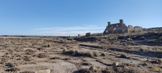


Laguna de La Playa, Saladas de Sástago-Bujaraloz
These saladas (salt lakes) make up an important part of the environment around the Monegros desert in Aragon. This one specifically has historically been used as a salt mine, and now it is protected as a Ramsar site. There are over 99 depressions close to this area that get flooded from time to time, but these saladas are the most important ones.
These lakes are endorheic, meaning they have no natural drainage. They are all made up of mainly gypsum, hence the prominent white rocks nearby. This location is very important for wildlife, with endangered halophyte (fauna and flora that can withstand/live in salty environments) plants such as Microcnemum coralloides, Halopeplis amplexicaulis, Limonium catalaunicum, or Macrochloa tenacissima (commonly known as esparto). These last two are not endangered. Aquatic fauna includes the endemic Candelacypris aragonica (a type of crustacean) or Artemia salina. The lizard Acanthodactylus erithurus, common in Iberian and Northeastern African desertic zones can also be seen there. Birds include the autarda (Otis tarda), the algavarán (Burhinus oedicnemus), or the chorla (Pterocles orientalis). Moreover, when the lakes fill up, more birds can be observed there, such as the churrupetas (Tringa totanus) or the chifleta (Actitis hypoleucos).
#it is a beautiful landscape honestly... if you guys have the chance (especially if you like flora and fauna!) i encourage yall to go!#polvo niebla viento y sol#saladas de bujaraloz#z puya cosetas#las mías fotos
11 notes
·
View notes
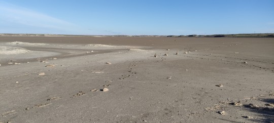
Text

Badwater Basin Refills
An ephemeral lake in Death Valley’s Badwater Basin is showing its staying power. After forming in August 2023 in the aftermath of Hurricane Hilary, the lake gradually shrank but persisted throughout the fall and winter. A potent atmospheric river filled it back up in February 2024.
This series of images compares the desert basin before flooding (left) with its more-waterlogged state following each major storm. In both August 2023 (middle) and February 2024 (right), a shallow lake several kilometers across fills in the low-lying salt flat. The images were acquired by the OLI (Operational Land Imager) sensor on Landsat 8 (left and right) and the OLI-2 on Landsat 9 (middle). They are false-color, shown with the OLI and OLI-2 band combination of 6-5-3, which emphasizes the presence of water in shades of blue.
The driest place in North America, Death Valley typically receives about 2 inches (51 millimeters) of rain per year. However, in the past six months alone, more than double that—4.9 inches (125 millimeters)—fell at the national park’s official weather gauge at Furnace Creek. Two events were responsible for most of that precipitation. The remnants of Hurricane Hilary delivered 2.2 inches on August 20, 2023, and an atmospheric river brought another 1.5 inches from February 4–7, 2024, according to park officials.
Following the August deluge, “most of us thought the lake would be gone by October,” said Death Valley National Park ranger Abby Wines in a news release. “We were shocked to see it still here after almost six months.” That was before the rains returned in February.
After the early February atmospheric river moved through, observers on the ground saw the lake continue to expand as water drained into the area. On February 11, park ranger Matthew Lamar noted: “The Amargosa River [which feeds the basin from the south] is really flowing, and we’ve noticed the water level continue to rise over the last couple of days as waters make their way to the basin.”
Badwater Basin is endorheic, meaning that water flows into but not out of it. Typically, evaporation far outpaces inputs, rendering the lake ephemeral. But in the past six months, the influxes have changed the equation.
Based on satellite imagery, the lake appears to have grown to a similar size in February 2024 as it did in August 2023, thereby extending its months-long tenure. This comes as welcome news to visitors, who have enjoyed witnessing stunning reflections of the surrounding peaks in its calm waters.
As of February 14, the lake is 1 foot deep in places, according to park officials, and it is uncertain how long it will last. Past appearances of the lake are rare and offer little insight into the current situation; when a lake formed in 2005, for example, it reportedly lasted about one week. It is also too early to know how the precipitation will affect the wildflower season, which runs from late-February to mid-April, they said.
NASA Earth Observatory images by Wanmei Liang, using Landsat data from the U.S. Geological Survey. Photo by K. Skilling/National Park Service. Story by Lindsey Doermann.
3 notes
·
View notes
Photo


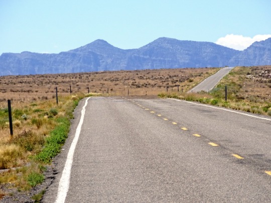


Highway 50 (No. 6)
Sevier Lake is an intermittent and endorheic lake which lies in the lowest part of the Sevier Desert, Millard County, Utah. Like Great Salt Lake and Utah Lake, it is a remnant of Pleistocene Lake Bonneville. Sevier Lake is fed primarily by the Beaver and Sevier rivers, and the additional inflow is from the lake's watershed that is part of the Escalante–Sevier hydrologic subregion. The lake has been mostly dry throughout recorded history and is a source of wind-blown dust.
The first recorded observation was in 1872, which stated that the lake's surface area was 188 square miles (490 km2), salinity was measured at 86 parts per thousand, two and a half times that of the ocean, and maximum depth was 15 feet (4.6 m). In January 1880, the lake was nearly dry and had been so for the past one or two years. The Sevier River, which once flowed to the lake, is now largely diverted for irrigation. In 1987 however, the lake was again similar to the recorded description of 1872.
The Domínguez–Escalante expedition named it "Laguna de Miera" after Bernardo de Miera y Pacheco, a cartographer on their 1776 expedition. In 1825, trappers working for William Henry Ashley trapped the region, and Jedediah Smith named it after him, the Ashley Lake. On some maps, it was named after Joseph Nicollet in the mid-19th century. The lake is currently named for the river, which is derived from "Río Severo" (wild river [Wild in modern Spanish is Salvaje or Silvestre]), a local name given by early Spanish explorers.
Source: Wikipedia
#Millard County#Sevier Lake#old Highway 6#upaved#Sevier Desert#USA#Highway 50#The Loneliest Road in America#US Route 50#Highway 6#travel#road trip#landscape#countryside#tourist attraction#landmark#potassium sulfate#Utah#Western USA#summer 2022#original photography#vacation#flora#clouds#mountains
3 notes
·
View notes
Text
Botswana
General Information
Botswana is a country in Southern Africa. The region has been inhabited by Khoisan for about 19.000 years, with Bantu influence starting to appear around 2.000 years ago. For most of the past Millennium, various states and dynasties, especially of the Tswana people, have been ruling over different areas of the region. From 1885 to the independence of Botswana in 1966, the region formed the British Bechuanaland protectorate. Majority of the inhabitants are Tswana, with Kalanga, another Bantu group, being the largest minority. Smaller minorities include San and White Afrikaners. Most Batswana are Christians. The official language is English, the national language is Tswana.

Elephants
Botswana has the largest elephant population in Africa. There are about 130.000 elephants in Botswana, which is nearly one third of all elephants in Africa. Many tourists come to Botswana to see the elephants, Chobe National Park in particular is famous for its many elephants.

~ Anastasia
Economy
The economy of Botswana is currently one of the world's fastest growing economies, averaging about 5% per annum over the past decade. Growth in private sector employment averaged about 10% per annum during the first 30 years of the country's independence. After a period of stagnation at the turn of the 21st century, Botswana's economy registered strong levels of growth, with GDP growth exceeding 6-7% targets. Botswana has been praised by the African Development Bank for sustaining one of the world's longest economic booms. Economic growth since the late 1960s has been on par with some of Asia's largest economies. The government has consistently maintained budget surpluses and has extensive foreign-exchange reserves.

Okavango Delta
The Okavango Delta in Botswana is a swampy inland delta formed where the Okavango River reaches a tectonic trough at an altitude of 930–1,000 m in the central part of the endorheic basin of the Kalahari. All the water reaching the delta is ultimately evaporated and transpired and does not flow into any sea or ocean. Each year, about 11 cubic kilometres of water spreads over the 6,000–15,000 km2 area. Some flood waters drain into Lake Ngami. The area was once part of Lake Makgadikgadi, an ancient lake that had mostly dried up by the early Holocene.
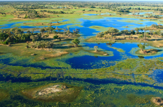
~ Damian
Sources:
https://www.britannica.com/place/Botswana
https://theculturetrip.com/africa/botswana/articles/botswanas-elephants-and-where-to-find-them/
https://en.wikipedia.org/wiki/Economy_of_Botswana
https://en.wikipedia.org/wiki/Okavango_Delta
5 notes
·
View notes
Text
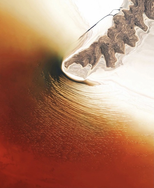
Lake Urmia is an endorheic salt lake in northwestern Iran. It was once the sixth-largest saltwater lake on Earth with a surface area of 2,000 square miles (5,200 square km), but by 2017 had shrunk to 10% of its original size due to drought and damming of inflow rivers. The lake’s red-orange color comes from a high concentration of halophiles, or “salt-loving” bacteria and algae, which have pigments ranging from pink to deep red.
4 notes
·
View notes
Text
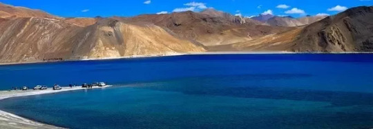
PANGONG TSO , LEH LADAKH ~ WHAT TO DO IN PANGONG LAKE ~ WHY IS PANGONG TSO SALTY
#kashmir#sonmarg#gulmarg kashmir#pahalgam#dal lake#manasbal lake#sonmarg kashmir#gulmarg#srinagar#pahalgam kashmir#trees and forests#mountains#fog#trees#forest#natute#nature#natasha romanoff
0 notes
Text

The Spotted Lake from the shoulder of Highway 3. It is a saline endorheic alkali lake located northwest of Osoyoos in the eastern Similkameen Valley of British Columbia, Canada.
55 notes
·
View notes
Text

Lake Urmia is an endorheic salt lake in northwestern Iran. It was once the sixth-largest saltwater lake on Earth with a surface area of 2,000 square miles (5,200 square km), but by 2017 had shrunk to 10% of its original size due to drought and damming of inflow rivers. The lake’s red-orange color comes from a high concentration of halophiles, or “salt-loving” bacteria and algae, which have pigments ranging from pink to deep red.
See more here: https://bit.ly/3LmX773
37.700000°, 45.366667°
Source imagery: Maxar
436 notes
·
View notes
Photo
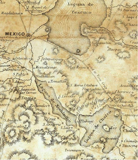
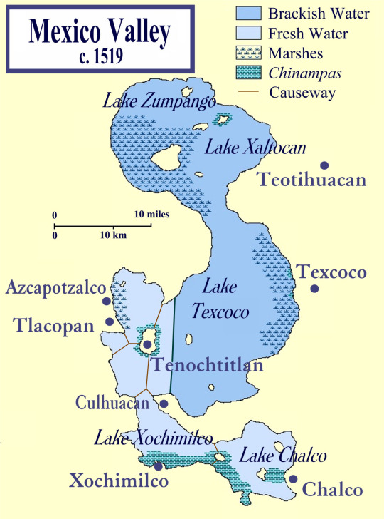
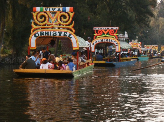

Lake Xochimilco is an ancient endorheic lake, located in the present-day Borough of Xochimilco in southern Mexico City. The lake is within the Valley of Mexico hydrological basin, in central Mexico.
Lake Xochimilco was originally a part of an even larger Lake Texcoco during the last glacial period. Between 12,000 and 6,000 years ago, the climate in central Mexico warmed and the snowmelt that once fed Lake Texcoco virtually disappeared. This caused the lake to drop hundreds of feet over next several thousand years. By 2,000 years ago Xochimilco became a bay in the southern portion of Texcoco. Then around the 13th or 14th century the Aztecs built large causeways effectively creating a new lake.
1 note
·
View note
Text
Aksai Chin Lake or Aksayqin Lake, (Chinese: 阿克赛钦湖; pinyin: Ākèsàiqīn Hú) is an endorheic lake in the disputed region of Aksai Chin. The plateau is administered by China but also claimed by India. Its Tibetan/Ladakhi name is Amtogor Lake[2][3] which means "encounter with a round object".[4]
0 notes
Last Seen Blogs

visualdirt
visualdirt

criticalkins
CriticalKins

selewecorolla
Untitled

web-hosting5485
Untitled

plcybill
𝐛𝐫𝗼𝐚𝐝𝐰𝐚𝐲, 𝐛𝐚𝐛𝐲!