#river maps
Text
Hey All,
I've been away for some time, as we've been working really hard on something quite exciting:
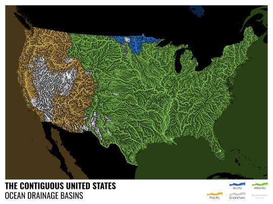
let me present to you the world's first ever global ocean drainage basin map that shows all permanent and temporary water flows on the planet.

This is quite big news, as far as I know this has never been done before. There are hundreds of hours of work in it (with the data + manual work as well) and it's quite a relief that they are all finished now.
But what is an ocean drainage basin map, I hear most of you asking? A couple of years ago I tried to find a map that shows which ocean does each of the world's rivers end up in. I was a bit surprised to see there is no map like that, so I just decided I'll make it myself - as usual :) Well, after realizing all the technical difficulties, I wasn't so surprised any more that it didn't exist. So yeah, it was quite a challenge but I am very happy with the result.
In addition to the global map I've created a set of 43 maps for different countries, states and continents, four versions for each: maps with white and black background, and a version for both with coloured oceans (aka polygons). Here's the global map with polygons:
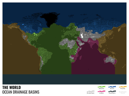
I know from experience that maps can be great conversation starters, and I aim to make maps that are visually striking and can effectively deliver a message. With these ocean drainage basin maps the most important part was to make them easily understandable, so after you have seen one, the others all become effortless to interpret as well. Let me know how I did, I really appreciate any and all kinds of feedback.
Here are a few more from the set, I hope you too learn something new from them. I certainly did, and I am a geographer.
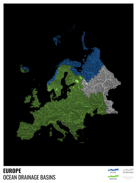
The greatest surprise with Europe is that its biggest river is all grey, as the Volga flows into the Caspian sea, therefore its basin counts as endorheic.
An endorheic basin is one which never reaches the ocean, mostly because it dries out in desert areas or ends up in lakes with no outflow. The biggest endorheic basin is the Caspian’s, but the area of the Great Basin in the US is also a good example of endorheic basins.
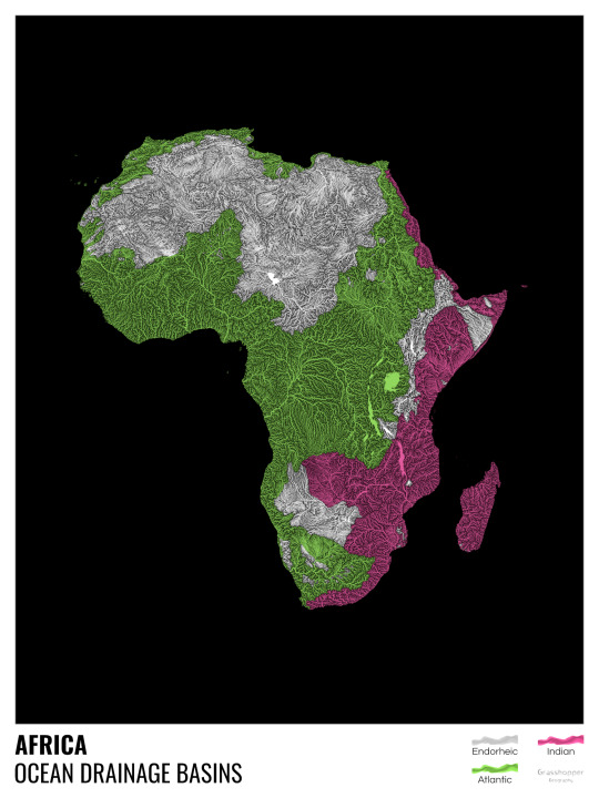
I love how the green of the Atlantic Ocean tangles together in the middle.
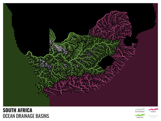
No, the dividing line is not at Cape Town, unfortunately.
I know these two colours weren’t the best choice for colourblind people and I sincerely apologize for that. I’ve been planning to make colourblind-friendly versions of my maps for ages now – still not sure when I get there, but I want you to know that it’s just moved up on my todo-list. A lot further up.
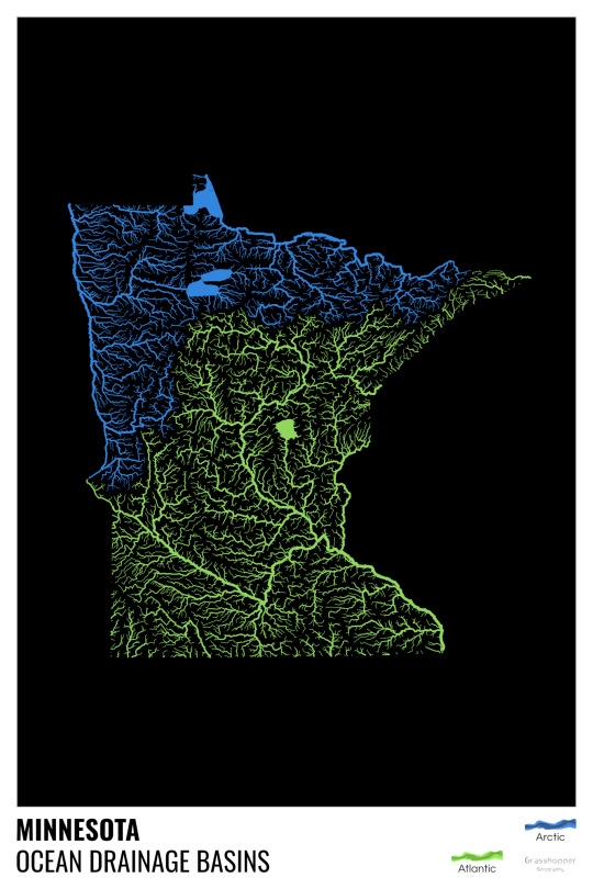
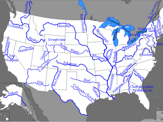
Minnesota is quite crazy with all that blue, right? Some other US states that are equally mind-blowing: North Dakota, New Mexico, Colorado, Wyoming. You can check them all out here.
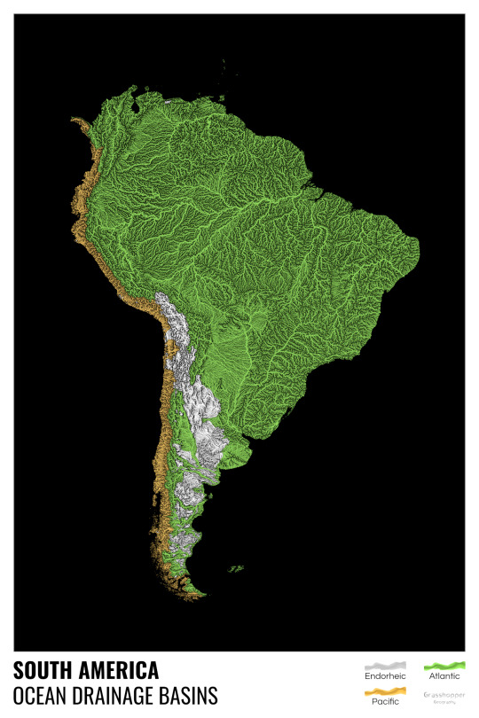
Yes, most of the Peruvian waters drain into the Atlantic Ocean. Here are the maps of Peru, if you want to take a closer look.
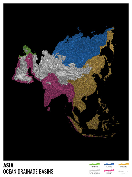
Asia is amazingly colourful with lots of endorheic basins in the middle areas: deserts, the Himalayas and the Caspian sea are to blame. Also note how the Indonesian islands of Java and Sumatra are divided.
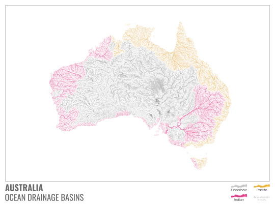
I mentioned earlier that I also made white versions of all maps. Here’s Australia with its vast deserts. If you're wondering about the weird lines in the middle: that’s the Simpson desert with its famous parallel sand dunes.
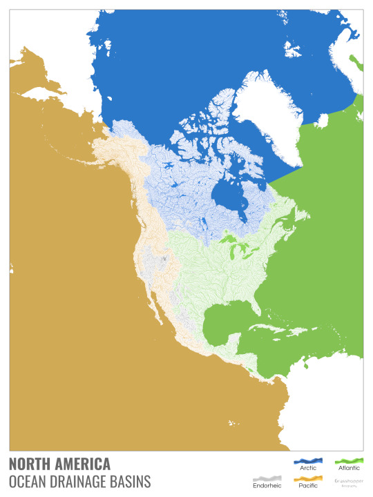
North America with white background and colourful oceans looks pretty neat, I think.

Finally, I made the drainage basin maps of the individual oceans: The Atlantic, the Arctic, the Indian and the Pacific. The Arctic is my favourite one.
I really hope you like my new maps, and that they will become as popular as my river basin maps. Those have already helped dozens of environmental NGOs to illustrate their important messages all around the world. It would be nice if these maps too could find their purpose.
#maps reimagined#geography#cartography#maps#my art#rivers of the world#ocean drainage basins#ocean maps#river maps
16K notes
·
View notes
Text

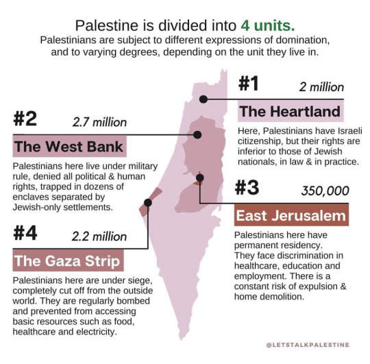
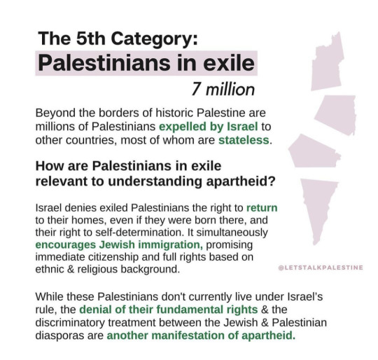
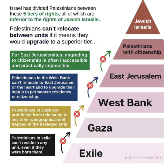
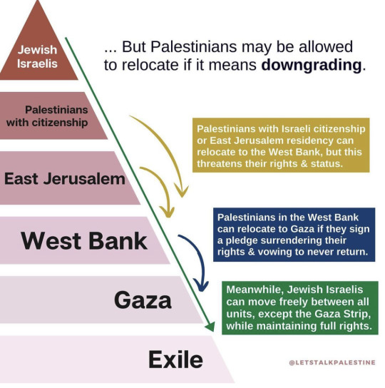
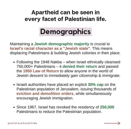

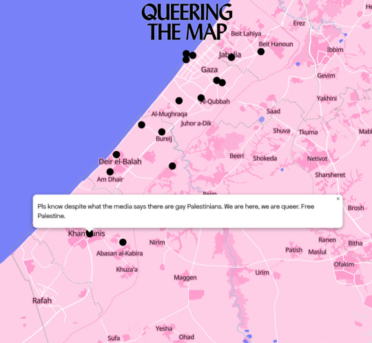
This is a simple introduction to how Israel rules Palestine 🇵🇸
#free palestine#palestine#gaza#israel terrorist#israel is a terrorist state#israel#stop israel#end the occupation#occupied palestine#occupation#politics#stop killing civilians#stand with gaza#map#justice for palestine#jewsforpalestine#jewish#freepalastine🇵🇸#from the river to the sea palestine will be free#palestine will be free#israelterrorists#support palestine#stop genocide
9K notes
·
View notes
Text
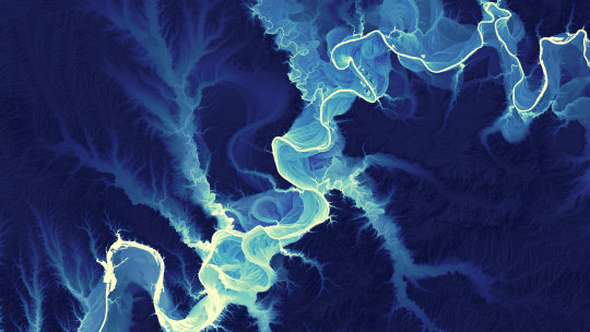


Lidar-Derived Aerial Maps Reveal the Dramatic Meandering Changes in River Banks Over Millennia
4K notes
·
View notes
Text
The marauders (and hats that they would have used)
James:
Remus:

Sirius:
Peter:

Lily:
Mary:
Marlene:

Regulus (bonus i guess!):

#marauders#the marauders#the maraunders map#moony wormtail padfoot and prongs#wolfstar#sirius black#remus lupin#remus x sirius#moony and padfoot#moony x padfoot#all the young dudes#atyd#atyd marauders#just lovers like we were supposed to be#crimson rivers#regulus black#james potter#jegulus#lily evans#jily#mary macdonald#mary x lily#marlene mckinnon#prongs#peter pettigrew#james & peter & remus & sirius#wormtail#harry potter#hp headcanon#hogwarts
3K notes
·
View notes
Text

Hello, everyone!
Nature is beautiful, and there's nothing quite like taking your caravan of goods from city to city all the while taking in some splendid sights: rivers, mountains and all kinds of forests.
It's too bad then that highway robberies are all the rage among lollygagging aficionados. It's true, no one can enjoy these vistas without someone trying to steal everything you have and more.
Good thing this caravan is full of seasoned warriors!
The creature tokens for this map are a Blood Feasting Beast, a Crow Demon and a Thieving Fairy. Emerald tier gets Crow Demon while Diamond tier gets all three. In addition, Sapphire tier gets extra creature token variants.
You can see a preview of all of this week’s Patreon content here.
Thank you very much for taking a look and be sure to check out my Patreon where you can pledge for gridless version, alternate map versions as well as the tokens pertaining to this map.
199 notes
·
View notes
Text


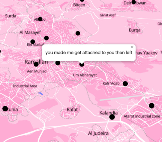
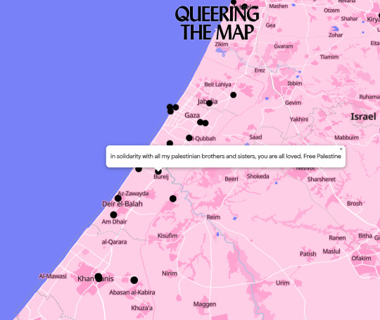
you can't be lgbtq and support the occupation that did this to them
#free palestine#palestine#from the river to the sea palestine will be free#pro palestine#boycott israel#news from the world#gaza#boycott starbucks#boycott disney#boycott mcdonalds#queering the map#palestinian queers#lgbtq#lgbtq community#save palestinians#god these stories are so sad#every person killed was someone's everything#jabalya#fuck israel#fuck the us#fuck zionism#kill israel#that bullet killed both of us#the palestinians are not numbers#fuck the occupation#bombs#bombing#gaza under bombardment#gaza under siege#gaza under genocide
239 notes
·
View notes
Photo
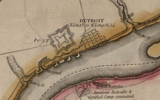
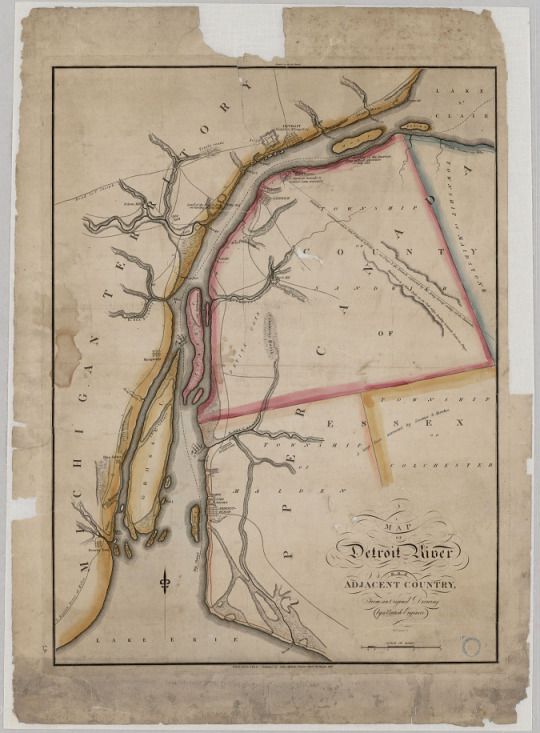
Map of Detroit River and Adjacent Country, August 26, 1813.
Record Group 64: Records of the National Archives and Records Administration
Series: Reference Maps and Drawings
File Unit: Michigan
Image description: Zoomed-in portion of a map of the Detroit River, showing the tiny grid of streets that indicate the town of Detroit, and the fort just to its west. Across the river on the Canadian side of the river are British Batteries, and the American Redoubt and fortified Camp, evacuated.
Image description: Map of the Detroit River from Lake Erie to Lake St. Clair. The Canadian townships and the Michigan Territory side of the river are bordered in different colors. Military fortifications and rivers are labeled, as is a tiny section of streets labeled “Detroit.” What we now know as Belle Isle is labeled “Hog I.”
#archivesgov#August 26#1813#1800s#maps#maps and charts#Detroit#Detroit River#Canada#gotta say Belle Isle is a nicer name
194 notes
·
View notes
Text

Map depicting the changing course of the Mississippi river. Harold Fisk 1944
828 notes
·
View notes
Text
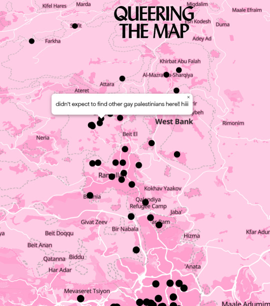
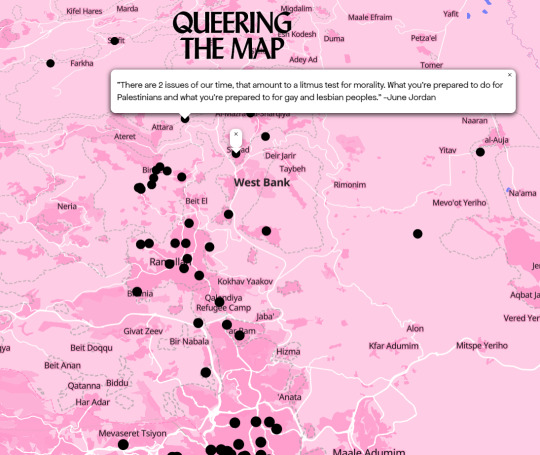
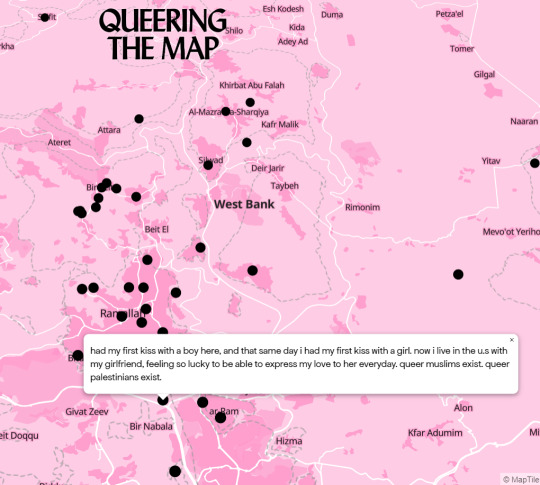
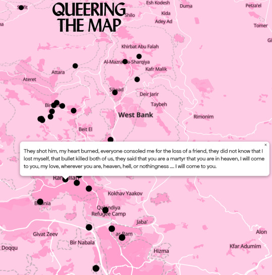

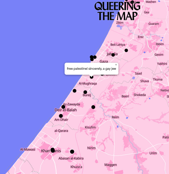
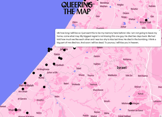
I remembered Queering The Map existed and I wanted to share some entries from Gaza and the West Bank. I would implore you guys to check out the website yourself as I couldn't fit all of them here.
It infuriates me to see Israeli propaganda that tried to garner support from queers as well as people saying you shouldn't support Palestine because ""they're homophobic.""
Most of all, in the midst of this, I am infuriated to see queer Palestinians be forgotten about.
We see you, Palestinian lesbians, gays, bi/pan/etc, trans men, trans women, nonbinary people, ace and aros, and many more. Most of all, we have not forgotten about you.
We see every single one of you and we STAND with every single one of you.
We stand with EVERY Palestinian.
Donate Esims to Gaza here.
Donate food packs, clean water, emergency shelter and more to Gaza here.
#free palestine#from the river to the sea palestine will be free#free gaza#end the occupation#end the genocide#ceasfire now#fuck israel#queer palestinians#lgbtq#lgbtqia#gay#lesbian#bisexual#pansexual#transgender#gay rights#trans rights#nonbinary#queering the map
61 notes
·
View notes
Text
the crimson rivers affect…
when you can’t imagine James Potter with a bow only an axe.
which Sirius just wouldn’t be sirius without a fucking spear.
and Regulus black having daggers is canon……
it’s making my writing / world planning very difficult guys….
😞‼️
#percy jackson#marauders era#marauders#marauders au#the marauders#james potter#jegulus#marauders map#sirius black#camp half blood#crimson rivers#slobstation
71 notes
·
View notes
Text
[Video Description: the octopath traveler party going down three flights of stairs in rowboats in the city of Ku. End Description.]
Having a normal one in Ku.
#Octopath Traveler#It did reset when I moved to a new map screen but I spent like five minutes scooting around ku first#Anyway if you would like to recreate this and haven't done the second Agnea and Hikari crossed paths quest#and i guess haven't entered ku at all since it became available since I don't think the game will prompt you again if you decline once#Enter Ku on the right via the river. You will be prompted to start the crossed paths quest. After the cut-scene ends your sprites do not#reset from the state they were in when you activated the cutscene and it drops you off right in the middle of town in your rowboats#wheeeeeeeeeeeeeeeee!
45 notes
·
View notes
Text
i think my favorite thing about the depths it's how the devs literally took the hyrule map, turned it inside out, and made that the depths map. absolutely genius time save
#and then they can just tweek and add polygons and shit to it. like damn!#mountains become pits! pits become mountains!#rivers and other bodies of water just join up the ceiling mirroring the way water joins down a map-wide body of water on the surface map!#it's so neat#tears of the kingdom#does this count as spoilers. probably not right#tortilla rambles
95 notes
·
View notes
Text
Preparing a Gävlebocken dnd oneshot for new year's eve was not on my to do list for this year but here we are
#gävle goat#map is literally the city of gävle#and I was really pleased to see the goat is across a river#I'm also getting a mini straw goat to burn at the end#the goat will burn
77 notes
·
View notes
Photo
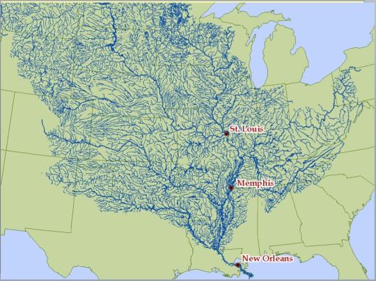
The Mississippi river and its tributaries.
13K notes
·
View notes
Photo
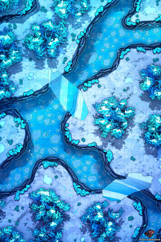
Greetings!
The adventurers have entered the frozen woods. While it might look like a beautiful, enchanting view, the dangers here present will surely pose a challenge to the mighty party of adventurers.
The icy leaves dangerously fall down, cutting the unsuspecting heroes while they're below. Frozen bridges aid them with crossing from one side to the other, just until it decides to break. The freezing cold waters of the river aren't really welcoming either, and are sure to damage most creatures not used to its temperature.
Can the heroes survive these new challenges?
You can see a preview of this map’s Patreon content by clicking here.
If you liked the map I’d be extremely thankful if you considered supporting me on my Patreon, rewards include higher resolution files, gridless versions, alternate versions, line versions, PSDs and more. Thank you!
#dnd#Dungeons and Dragons#pathfinder#snow#winter#rime of the frostmaiden#ice#river#dnd map#roll20#dicegrimorium
280 notes
·
View notes
Last Seen Blogs
dontwantithere
Ban

wariofan63
Nintendostuck

appleshipsahoy
Shipping is Awesome

chelseaboobear105
Disney/Lego

togelwin88
AGEN TOGEL ONLINE & LIVE CASINO TERPERCAYA | TOGEL ASIA