#Flood Resilience
Text
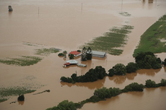
Tweed Valley Flood Study seeks community input
Residents are encouraged to attend one of seven community engagement sessions to provide feedback and help finalise the Tweed Valley Flood Study.
Enhanced flood mapping incorporates advances in hydrology practices and recent major flooding
Residents are encouraged to attend one of seven community engagement sessions to provide feedback and help finalise the Tweed Valley Flood Study. IMAGE: An aerial shot of an isolated property in the Tweed Valley after the 2022 flood.
Tweed Shire Council will host a series of information sessions in…
View On WordPress
#Chinderah#Flood Mitigation#Flood Resilience#floods#gold coast#Murwillumbah#northernrivers#NSW#places to go#Resilience#sustainability#Tweed Heads#Tweed Shire#Tyalgum#Uki
0 notes
Text
As relentless rains pounded LA, the city’s “sponge” infrastructure helped gather 8.6 billion gallons of water—enough to sustain over 100,000 households for a year.
Earlier this month, the future fell on Los Angeles. A long band of moisture in the sky, known as an atmospheric river, dumped 9 inches of rain on the city over three days—over half of what the city typically gets in a year. It’s the kind of extreme rainfall that’ll get ever more extreme as the planet warms.
The city’s water managers, though, were ready and waiting. Like other urban areas around the world, in recent years LA has been transforming into a “sponge city,” replacing impermeable surfaces, like concrete, with permeable ones, like dirt and plants. It has also built out “spreading grounds,” where water accumulates and soaks into the earth.
With traditional dams and all that newfangled spongy infrastructure, between February 4 and 7 the metropolis captured 8.6 billion gallons of stormwater, enough to provide water to 106,000 households for a year. For the rainy season in total, LA has accumulated 14.7 billion gallons.
Long reliant on snowmelt and river water piped in from afar, LA is on a quest to produce as much water as it can locally. “There's going to be a lot more rain and a lot less snow, which is going to alter the way we capture snowmelt and the aqueduct water,” says Art Castro, manager of watershed management at the Los Angeles Department of Water and Power. “Dams and spreading grounds are the workhorses of local stormwater capture for either flood protection or water supply.”
Centuries of urban-planning dogma dictates using gutters, sewers, and other infrastructure to funnel rainwater out of a metropolis as quickly as possible to prevent flooding. Given the increasingly catastrophic urban flooding seen around the world, though, that clearly isn’t working anymore, so now planners are finding clever ways to capture stormwater, treating it as an asset instead of a liability. “The problem of urban hydrology is caused by a thousand small cuts,” says Michael Kiparsky, director of the Wheeler Water Institute at UC Berkeley. “No one driveway or roof in and of itself causes massive alteration of the hydrologic cycle. But combine millions of them in one area and it does. Maybe we can solve that problem with a thousand Band-Aids.”
Or in this case, sponges. The trick to making a city more absorbent is to add more gardens and other green spaces that allow water to percolate into underlying aquifers—porous subterranean materials that can hold water—which a city can then draw from in times of need. Engineers are also greening up medians and roadside areas to soak up the water that’d normally rush off streets, into sewers, and eventually out to sea...
To exploit all that free water falling from the sky, the LADWP has carved out big patches of brown in the concrete jungle. Stormwater is piped into these spreading grounds and accumulates in dirt basins. That allows it to slowly soak into the underlying aquifer, which acts as a sort of natural underground tank that can hold 28 billion gallons of water.
During a storm, the city is also gathering water in dams, some of which it diverts into the spreading grounds. “After the storm comes by, and it's a bright sunny day, you’ll still see water being released into a channel and diverted into the spreading grounds,” says Castro. That way, water moves from a reservoir where it’s exposed to sunlight and evaporation, into an aquifer where it’s banked safely underground.
On a smaller scale, LADWP has been experimenting with turning parks into mini spreading grounds, diverting stormwater there to soak into subterranean cisterns or chambers. It’s also deploying green spaces along roadways, which have the additional benefit of mitigating flooding in a neighborhood: The less concrete and the more dirt and plants, the more the built environment can soak up stormwater like the actual environment naturally does.
As an added benefit, deploying more of these green spaces, along with urban gardens, improves the mental health of residents. Plants here also “sweat,” cooling the area and beating back the urban heat island effect—the tendency for concrete to absorb solar energy and slowly release it at night. By reducing summer temperatures, you improve the physical health of residents. “The more trees, the more shade, the less heat island effect,” says Castro. “Sometimes when it’s 90 degrees in the middle of summer, it could get up to 110 underneath a bus stop.”
LA’s far from alone in going spongy. Pittsburgh is also deploying more rain gardens, and where they absolutely must have a hard surface—sidewalks, parking lots, etc.—they’re using special concrete bricks that allow water to seep through. And a growing number of municipalities are scrutinizing properties and charging owners fees if they have excessive impermeable surfaces like pavement, thus incentivizing the switch to permeable surfaces like plots of native plants or urban gardens for producing more food locally.
So the old way of stormwater management isn’t just increasingly dangerous and ineffective as the planet warms and storms get more intense—it stands in the way of a more beautiful, less sweltering, more sustainable urban landscape. LA, of all places, is showing the world there’s a better way.
-via Wired, February 19, 2024
#california#los angeles#water#rainfall#extreme weather#rain#atmospheric science#meteorology#infrastructure#green infrastructure#climate change#climate action#climate resilient#climate emergency#urban#urban landscape#flooding#flood warning#natural disasters#environmental news#climate news#good news#hope#solarpunk#hopepunk#ecopunk#sustainability#urban planning#city planning#urbanism
14K notes
·
View notes
Text
Strengthen Flood Resilience, Improve Livability.
The World Bank Board of Directors today approved a project to strengthen flood resilience and improve sanitation, transport, and public space infrastructure in Vinh City, a political, economic, and cultural center of Vietnam’s North Central Coast region.
The US$ 129.6 million Nghe An Province Vinh City Priority Infrastructure and Urban Resilience Development Project will directly benefit a quarter of a million residents in Vinh City’s urban core by reducing flood risk and improving public health. Once completed, the project, will connect 30,000 households to new or rehabilitated secondary and tertiary sewers, and reduce the time women spend on unpaid housework after flooding, including cleaning, by half. The project will contribute to climate adaptation by reducing damage from heavy rains, and to climate mitigation by improving living conditions in the city’s center and the construction of pedestrian and bike lanes.
“The Vinh City project is more than just infrastructure; it's a transformative endeavor enhancing the socioeconomic conditions of Vinh City's inhabitants,” said World Bank Country Director for Vietnam Carolyn Turk. “The project embodies the World Bank’s commitment to assisting Vietnam in achieving sustainable urbanization and resilient growth”
The project design reflects lessons learned about urban resilience and disaster risk management in Vietnam and builds on the World Bank’s Vietnam Country Climate and Development Report by supporting the city’s ability to predict and respond to floods and engage in more climate-sensitive urban planning. Investments include flood control systems, wastewater collection and treatment infrastructure, and transport links to promote sustainable urban growth and climate resilience.
Vinh City lacks the capacity to cope with severe rainfall events, resulting in stormwater pooling at various locations throughout the city. To improve the drainage system, a new lake will be built to store excess stormwater runoff in an expanded flood basin within the city. The project will also support the conversion of vacant land on both sides of the Vinh River into green public spaces while improving waste collection and separation to reduce the quantity of plastic waste disposed into the rivers.
0 notes
Photo

Devon-based initiative to pilot ‘smart gullies’ technology to prevent highway flooding
Devon County Council (DCC) has appointed technology company Previsico to trial connected water and silt level sensors along a subset of Devon’s highway gullies. The post Devon-based initiative to pilot ‘smart gullies’ technology to prevent highway flooding appeared first on New Civil Engineer.
https://www.newcivilengineer.com/latest/devon-based-initiative-to-pilot-smart-gullies-technology-to-prevent-highway-flooding-07-09-2023/
#Latest#Devon#devon county council#flood alleviation#flood resilience#Previsico#Belinda Smart#New Civil Engineer
0 notes
Text


"Disaster Taxon," poem assembled using text from Wikipedia articles
#wikipedia poem#wikipedia poetry#climate grief#grief#environmental grief#resilience#climate change#gilgamesh#flood narrative#post apocalyptic#poetry#my writing#wikipedia poems#weeds#plantarchy#mass extinction#dandelion#utnapishtim
12K notes
·
View notes
Text
#good news#science#nature#environmentalism#environment#climate change#climate crisis#flooding#climate adaptation#climate resilience#city design#infrastructure
40 notes
·
View notes
Text

Tangled High Marsh Grasses - September 17th 2023
#spartina patens#love this species too#the historic source of atlantic salt hay#a historic hay venerated in the romatic art period and also a highly desired cheap resilient farm crop#high marsh is a bit more diverse and typically flooded less frequently#careful walking on it crabs love to hide in the grass#easier to walk on honestly#photographers on tumblr#original phography#nature#njlocal#new jersey#delaware bay#nj#salt marsh
14 notes
·
View notes
Text
i'm going thru a lot of growth and transformation at the moment (maybe) but unfortunately i can only really express it thru agricultural and ecological metaphors
#U know when you've been overgrazing the field that is your life#So your life sward is really tightly cropped and has no resilience against metaphorical droughts and floods#and u might even experience spiritual soil loss#So u have to change ur management. For the good of the ecosystem#But it's rough because that involves having other pastures to draw on. U might not have that#u might have to lower ur stocking rate. Which is scary for anyone to contemplate!#But you have to! A little intense grazing is really helpful especially when the grass is growing strong#But part of making it grow strong includes leaving it time to rest#And cause this is all metaphorical u have to figure out what is grazing and what is sunshine and rain#Life hack real sunshine and real rain deffo count#Me Fein
13 notes
·
View notes
Text
Wildfires and Flooding: The Uninsurable Reality for Homeowners in California and Florida

As the United States grapples with the devastating impacts of climate change, two of its most populous states, California and Florida, are facing an unprecedented crisis. Annual wildfires and flooding are wreaking havoc on homes and communities, leaving homeowners in a precarious situation: major insurance companies are refusing to cover them.
The Reality in California
California has been ravaged by wildfires in recent years, with the 2018 Camp Fire being the deadliest and most destructive in the state's history. The fire burned over 153,000 acres, destroyed nearly 19,000 structures, and claimed 85 lives. The economic toll was staggering, with estimated damages exceeding $16.5 billion.
In the aftermath of such disasters, homeowners are finding it increasingly difficult to secure insurance coverage. Major insurance companies like State Farm, Allstate, and Liberty Mutual are either refusing to renew policies or canceling them altogether, citing the high risk of wildfires in the region.
The Reality in Florida
Florida, meanwhile, is battling a different kind of disaster: flooding. Rising sea levels, heavy rainfall, and storm surges are causing widespread flooding, especially in coastal areas like Miami and Key West. The 2017 Hurricane Irma caused an estimated $83 billion in damages, with many homeowners still struggling to recover.
Insurance companies are taking note of the increasing frequency and severity of flooding in Florida, and are adjusting their policies accordingly. Some are imposing hefty rate hikes, while others are simply refusing to cover homes in high-risk flood zones.
The Consequences
The lack of insurance coverage has severe consequences for homeowners in California and Florida. Without insurance, homeowners are left to foot the bill for damages and repairs, which can be financially crippling. Many are forced to take out expensive loans or dip into their savings to cover the costs, leading to financial hardship and even bankruptcy.
Moreover, the lack of insurance coverage can also affect property values and the overall economy. As homes remain uninsured and unrepaired, neighborhoods can become blighted, leading to a decline in property values and a decrease in local economic activity.
The Solution
So, what can be done to address this crisis? Some possible solutions include:
Implementing stricter building codes and zoning regulations to reduce the risk of wildfires and flooding
Investing in mitigation measures like fire breaks and flood-control infrastructure
Creating state-funded insurance programs or reinsurance pools to provide coverage for high-risk areas
Encouraging private insurance companies to offer more affordable and accessible coverage options
Conclusion
The reality of wildfires and flooding in California and Florida is stark. Homeowners are facing an uncertain future, with major insurance companies refusing to cover them. It's time for policymakers, insurance companies, and homeowners to come together to find solutions to this crisis. By working together, we can build more resilient communities and ensure that homeowners are protected from the devastating impacts of climate change.
#ClimateChange#Wildfires#Flooding#InsuranceCrisis#California#Florida#NaturalDisasters#Homeowners#Mitigation#Resilience#PolicySolutions#EconomicImpact
0 notes
Text
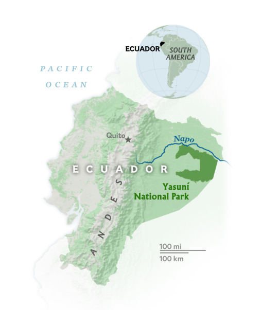
In The Heart Of The Amazon, This Pristine Wilderness Shows Nature’s Resilience
Ecuador’s Yasuní National Park, Along the Banks of the Napo River, Shows How Biodiversity Can Thrive When Humans Don’t Interfere.

A Butterfly sits perched on the shell of an endangered Yellow-Spotted River Turtle (Podocnemis Unifilis). The butterfly is drinking the turtle’s tears—a symbiotic behavior where the insect obtains minerals, especially sodium, to compensate for its scarcity in this environment.
— Photographs byThomas Peschak | ByJúlia Dias Carneiro | April 22, 2024
Amid the din of tragic tales of Environmental Degradation in the Amazon, there are other, quieter but no less compelling stories testifying to the sheer power of nature to thrive when left untouched. Such is the case of the Napo River, which flows along the north of Ecuador’s Yasuní National Park.
“It’s a place where all your senses explode. You’re not just seeing life all over, you’re hearing calls of birds, frogs, the wind; smelling the pollen of plants, the soil, the rain. It’s overwhelming,” says biologist, conservationist and environmental Photographer Lucas Bustamante. “For anyone in love with nature, it’s like being a kid in a toy store.”
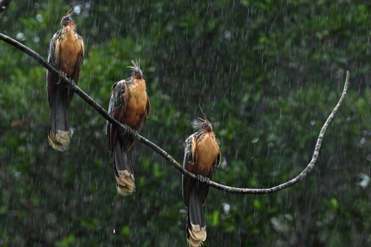
A trio of Hoatzins (Opisthocomus Hoazin) hang over a stream by the Napo River. Hoatzins build their nests above streams as a protection mechanism. If predators try to raid their nests, the young chicks leap to the water to escape, and use their claws to climb back into their nests once the danger has passed.
Established in 1979 in northwestern Amazonia, Yasuní National Park is the largest conservation area in Ecuador. It protects some 1,1 million hectares of Amazon rainforest, an area roughly the size of Croatia. It’s one of the most biodiverse forests on the planet—and the Napo River is the artery pumping life into its heart.
The river begins in the high slopes of the Andes to the east and marks the park’s northern frontier. It eventually joins the Amazon River to the west, after crossing into Peru.
Bustamante is from Ecuador, and he organizes expeditions for photographers into Añangu, a village by the Napo River managed by local Kichwa indigenous families. Twenty years ago, the group decided to Pursue Ecotourism instead of logging and hunting as their main source of income. The project has thrived, and so has nature.
“It took a few years for the animals to start coming back, and for the forest to start recovering,” Bustamante says. “Right now, it’s like a small paradise, an island of biodiversity.”
Soren Walljasper, NG Staff
‘Aquatic Spiderweb’
This pristine space was the perfect place for photographer Thomas Peschak, who wanted to capture the deep connections between the Amazon’s animals and its waterways. A National Geographic Explorer, Peschak is working on a long-term project to document the rainforest from the water—its “aquatic spiderweb” of giant rivers with hundreds of tributaries and thousands of streams.
He and Bustamante spent weeks on a canoe paddling on the creeks around the Napo River, looking for endemic species like the giant river otter. These endangered mammals are among the Amazon’s top five predators, wolfing down seven pounds of fish in one day. Their presence is a strong indicator of a healthy Aquatic Ecosystem.
“Across the Amazon we are seeing things deteriorate, but Napo really bucks the trend. Because there’s no poaching, illegal logging or mining a lot of the wildlife around the river is incredibly relaxed around people,” says Peschak.
That ease, in turn, gives Peschak a unique opportunity to capture and showcase many animals’ behavior in the wild, like a butterfly drinking the tears from a river turtle’s eyes, a giant otter snatching up a fish, and red howler monkeys feeding on leaves above a stream.
Not everything is so simple, however. In the days before Peschak’s expedition, heavy rain swelled the Andean headwaters. Water levels in the Napo River rose dramatically, making its streams overflow and bleed into the forest.
The flood, while not unusual for the river and its ecosystem, made the explorers’ search for otters much harder. The flooded streams meant that the animals could swim far inside the flooded forest, away from the main riverways. So Peschak and Bustamante spent seven days paddling with no otters in sight—until, on the final day, they saw a group of them feasting on fish.
“In this job, you have to be patient beyond stupidity,” says Peschak. “When every bone and brain cell in your body tells you to give up, that's when you have to keep going. Patience and persistence are rewarded by nature.”
Highway of Seeds
The remarkable biodiversity around the Napo River reflects its descent from the foothills of the Andes to the Amazon Basin. These ecosystems blend along its banks in a unique way, and this means that the Yasuní National Park has a vast array of species within its bounds.

A Red Howler Monkey (Alouatta Seniculus) spotted from a canoe on the water. These monkeys like to pick the best trees, leaves and fruits in the forest, and this connects them to healthy rivers and streams, where trees are always producing new, crunchy leaves. It’s impossible to ignore their presence in the Amazon: their vocalizations to mark territories can be heard miles away.
The Napo is also loaded with nutrients from the Andes, including rich ash from volcanic eruptions. It’s a whitewater river, which designates waterways carrying large amounts of sediments, giving them a muddy color. It’s also an efficient disperser of seeds. “The Napo River is like a highway in which millions of seeds travel from the Andes and across the region, helping species to propagate,” says biologist Gonzalo Rivas-Torres.
This flow of seeds is also a crucial food source for the great variety of fish found in the Napo’s waters. And this has ripple effects on the rest of the forest, far beyond the river’s bends.
“Fish depend on the amount of nutrients, fruits and seeds in the water. If the forests by the riversides aren’t in good shape, fish populations will be low, and otters won’t have enough food,” he explains. “Everything is connected.”
Rivas-Torres is the director of the Tiputini Biodiversity Station, a biological field station kept by Universidad San Francisco de Quito in collaboration with Boston University for research, education and conservation.
Their base is on the banks of the Tiputini River, a tributary of the Napo. From this perch, Rivas-Torres says he’s always spellbound to see wildlife so close and all around. His students have wept after seeing a jaguar in the wild for the first time, for example, or when releasing a yellow-spotted turtle back into the river.
“They say they didn’t expect to see this, or they didn’t know Ecuador was also this.” Rivas-Torres says. “It’s a life changing experience.”
#Rivers#Rain Forests#Wildlife Photography#Biodiversity#Floods#Fish 🎣🐟🐠#Wildlife#Heart of the Amazon#Pristine Wilderness#Nature’s Resilience#Ecuador’s Yasuní National Park | Banks of the Napo River#Thriving Biodiversity#No Human Interference#Butterfly 🦋 | Yellow-Spotted River Turtle 🐢 | Podocnemis Unifilis#Photographer | Lucas Bustamante#Hoatzins | Opisthocomus Hoazin#Amazon River#Red Howler Monkey 🙈🐵🐒 | Alouatta Seniculus
0 notes
Text
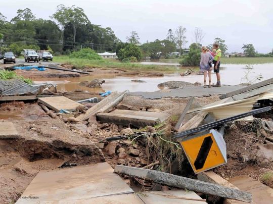
Tweed flood restoration continues two years on from disaster
A total of 3,742 road damage items were logged across the Tweed following the disaster, with additional damage to water and wastewater infrastructure, parks and sports fields, and some 90 Council-owned buildings impacted by the floodwaters.
Progress made but still a long way to go
Residents survey the destruction of Blacks Drain along Tweed Valley Way at South Murwillumbah in the days following the February-March 2022 deluge. (Photo credit Toni Kelly Fleeton)
Flood recovery remains a major focus of Tweed Shire Council, as the community marks two years since the worst natural disaster in the Tweed’s recorded history.Current…
View On WordPress
#Community Resilience Group#Flood#Flood Awareness#flood recovery#Flood Resilience Projects#flood restoration#Infrastructure Rebuild#Murwillumbah#Natural Disaster Recovery#northern rivers#NSW#Red Cross#tweed disaster#Tweed Shire#Tweed Shire Council
0 notes
Text
youtube
#disaster#disaster risk reduction#natural disaster#disastermanagement#disaster relief#floods#resilience#Youtube
0 notes
Text
Norfolk's $2.7 Billion Flood Protection Plan: A Balancing Act of Resilience and Equity
Norfolk, Virginia, is embarking on an ambitious $2.7 billion infrastructure project, the largest in its history, to combat the existential threat of rising seas and storm risks. This plan, underpinned by the 2015 Army Corps of Engineers strategy, is the first of its kind in the U.S. and aims to protect the city’s vulnerable waterfronts before disaster strikes.
Recent News
Project OverviewThe…

View On WordPress
#Climate Resilience#community impact#Equity in Infrastructure#Flood Protection#Norfolk Infrastructure#Rising Seas#Urban Planning
0 notes
Text
The aftermath of Cyclone jasper in Far North queensland was deadly.

View On WordPress
0 notes
Text
Quezon City's iRISE UP: Keeping Residents Prepared for Weather Events
In an innovative move, the Quezon City Disaster Risk Reduction and Management Office (QCDRRMO) transformed its COVID-19 dashboard into a powerful early warning system named iRISE UP (Intelligent, Resilient, and Integrated Systems for the Urban Population).
This groundbreaking system doesn’t just monitor the number of coronavirus cases but also keeps residents informed and prepared for various…

View On WordPress
#Community Preparedness#Disaster Response#Disaster Risk Reduction#Early Warning System#Flood Sensors#iRISE UP#Quezon City#Resilience#Seismic Accelerographs#Weather Forecast#Weather Monitoring
0 notes
Last Seen Blogs

bnvupdates
Borderless News And Views

mushymah-blog
This Blog Is Vore Free(for Now)

gamface
Atlanta Personal Paparazzi Photographer for Hire!