#tule lake
Photo
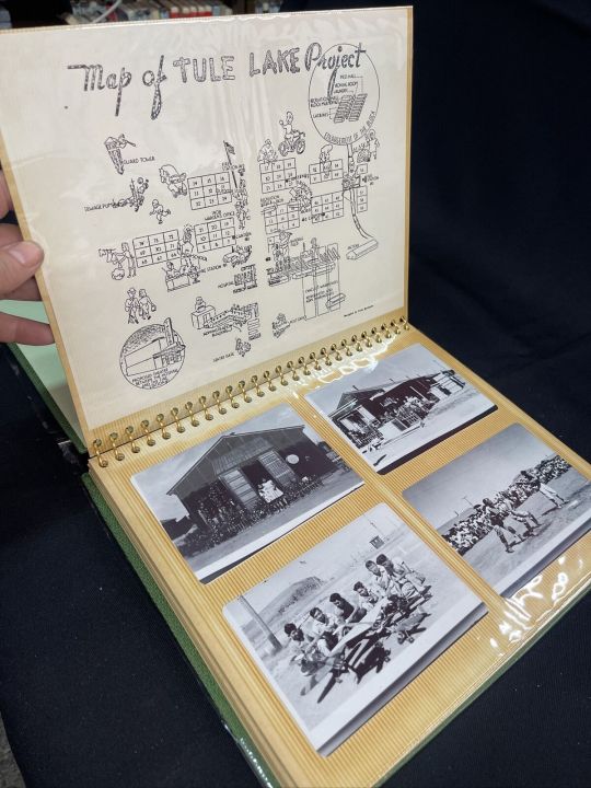

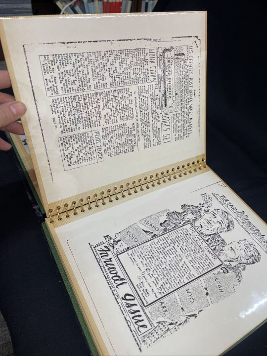

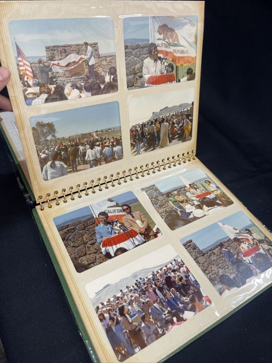
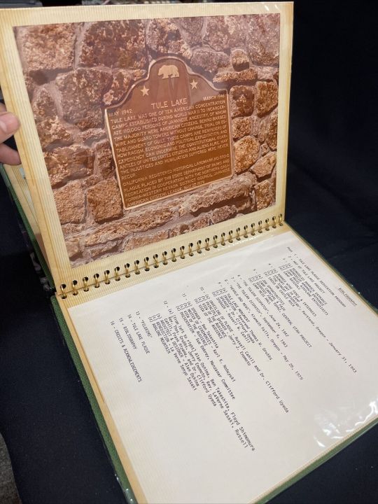
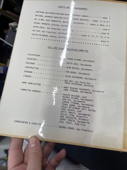
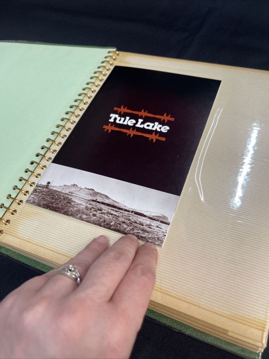
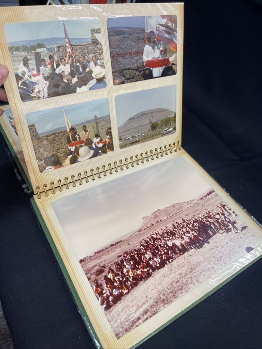
Project Tule Lake Memorabilia Photo Photograph Japanese Internment Memorial Lot ebay wendyki
0 notes
Text
#nature video#bird video#white pelican#pelecaniformes#pied billed grebe#podilymbus#aquatic birds#waterfowl#lake#wildlife#tule reeds#aquatic plants#sepulveda basin wildlife reserve#van nuys#video
1 note
·
View note
Text
A historically and culturally significant lake in California's San Joaquin Valley that first disappeared in 1898 has returned after last year's atmospheric rivers flooded the region.
Tulare Lake, known as Pa'ashi — or "big water" — to the local Tachi Yokut Tribe, was "once the largest body of freshwater west of the Mississippi River," per Earth.com.
Vivian Underhill, who published a paper on Tulare Lake as a postdoctoral research fellow at Northeastern University, noted it was mostly sustained by snowmelt from the Sierra Nevada mountains and was 100 miles long and 30 miles wide at its peak.
The lake served as a key resource for Indigenous Peoples and wildlife and was once robust enough to allow steamships to transport agricultural goods throughout the state.
However, government officials persecuted and displaced the indigenous communities in the late 1800s to convert the area for farming through draining and irrigation.
"They really wanted to get [land] into private hands so that indigenous land claims — that were ongoing at that time — would be rendered moot by the time they went through the courts," Underhill told the Northeastern Global News. "It was a deeply settler colonial project."
While Pa'ashi periodically reappeared during the 1930s, '60s, and '80s, the barrage of atmospheric rivers California experienced in 2023 revived the lake despite the region receiving just 4 inches of rain annually. According to Underhill, Tulare Lake is now the same size as Lake Tahoe, which is 22 miles long and 12 miles wide.
Its resurgence has led to the return of humid breezes at least 10 degrees cooler than average and native species, including fish, amphibians, and birds. Lake Tulare was once a stopping point for migratory birds traveling a route known as the Pacific Flyway.
"Something that continues to amaze me is — [the birds] know how to find the lake again," Underhill told the Northeastern Global News. "It's like they're always looking for it."
The Tachi Yokuts have also returned to Pa'ashi's shores, once again practicing their ceremonies and planting tule reeds and native sage.
#submission#!!!#good news#lakes#Tulare Lake#Pa'ashi#big water#water#water is life#revitalization#anti colonialism#decolonization#nature#Tachi Yokut#indigenous peoples
412 notes
·
View notes
Text

Carl Mydans Young Japanese-American Man Incarcerated at a Relocation Camp, Tule Lake, CA 1944
111 notes
·
View notes
Text

Legends and myths about trees
Forest myths, Estonian traditional beliefs (3)
The world of the Estonians’ ancestors – Kaali crater, the place where "The sun went to rest"
Kaali is a group of nine meteorite craters in the village of Kaali on the Estonian island of Saaremaa. It was created by an impact event. The largest crater is 110 m (360 ft) in diameter and forms a small lake named Lake Kaali.
The impact is thought to have happened in the Holocene period, around 3,500 years ago. The estimates of the age of the Kaali impact structure provided by different authors vary by as much as 6,000 years, ranging from ~6,400 to ~400 years before current era (BCE). According to the theory of more recent impact, Estonia at the time of impact was in the Nordic Bronze Age and the site was forested with a small human population. The impact energy of about 80 TJ (20 kilotons of TNT) is comparable with that of the Hiroshima bomb blast. It incinerated forests within a six km (3.7 mi) radius.
The event figured prominently in regional mythology. It was, and still is, considered a sacred lake. There is archaeological evidence that it may well have been a place of ritual sacrifice.
It is possible that Saaremaa was the legendary Thule island, first mentioned by ancient Greek geographer Pytheas, whereas the name "Thule" could have been connected to the Finnic word tule ("(of) fire") and the folklore of Estonia, which depicts the birth of the crater lake in Kaali. Kaali was considered the place where "The sun went to rest."
[Image below: the crater as viewed from near the rim]

森の神話・エストニアの民間伝承 (2)
エストニア人の祖先の世界 〜 "太陽が休息する場所 "、カーリー・クレーター
カーリ・クレーターは、エストニアのサーレマー島にある9個の隕石クレーター群である。このクレーター (噴火口) は衝突現象によって形成されたものでである。最も大きいクレーターは直径110mでカーリ湖という名の小さな湖になっている。
この衝突は完新世、およそ3,500年前に起こったと考えられている。カーリ衝突構造の推定年代は、著者によって6,000年も異なっており、現在の時代 (紀元前) より6,400年前から400年前までである。より最近の衝突説によれば、衝突当時のエストニアは北欧青銅器時代で、この地は森林に覆われ、小規模な人間しか住んでいなかった。約80TJ (TNT20キロトン)という衝撃エネルギーは、広島原爆の爆風に匹敵する。半径6km (3.7マイル) の森林を焼却した。
この出来事は、この地域の神話において重要な位置を占めている。昔も今も、この湖は神聖な湖と考えられている。儀式の生贄の場所であった可能性を示す考古学的証拠もある。
サーレマー島は古代ギリシャの地理学者ピュテアスが最初に言及した伝説上のトゥーレ島であった可能性があり、一方、「トゥーレ」という名前はバルト・フィン諸語のトゥーレ (“火の”の意) や、カーリにある火口湖の誕生を描いたエストニアの民間伝承と結びついている可能性がある。カーリは "太陽が休息する場所 "と考えられていた。
#trees#tree legend#tree myth#kaali#saaremaa#estonia#estonian mythology#kaali crater#impact event#tule#nature#art#mythology#legend#folklore
118 notes
·
View notes
Text
The beginning of a battle of love
Rottmnt four kings au x reader

There are four kingdoms in the land the
First mushroom kingdom in the east that was nice and calm and colorful that had the toads as there people. As they had a not of hold and the rulers castle was on the highest hill of the land for all to see.
There king well not really king since he called himself the prince instead of a king. There ruler Leo although was nice to the kingdoms even if there tule didn’t go to the importante meets or anything that was urgent.
Second in the north what the Koop kingdom that was known for there volcanic lands and many hot environments. That had koopas and gumbas as there people.
With militant lava lakes and rives and well and a castle have of stone and iron that was many in the ground but was also able to be mobile as well if wanted to be.
This kingdom was manly known for there battle and grate fighting army as well as defense, and a good king to go along with it.
The kingdom of the topas had there king Raph that looks to be very mean and scary at first glance.
With his spikes she’ll that poked throw his cape and scarp claw as and horns. Plus with how big he was also intimidated many. But Raph was a good king and a nice one at that even with his looks. Self training the army making the kingdom stronger and re building homes and places free of charge after a battle. He also unknown to many has a few fundraiser for children and orphanages in his kingdom.
Next in the West was the boos kingdom where all the boo’s and other ghostly creatures are. This kingdom always had a more 1900’s haunting house feel to it. But as well had a a constant climate of rain and thunderstorms.
The kingdom as well was many surrounded by a a big forest.That was almost dead looking giving more to that Victoria hunted ascetic.the homes were many mansions apartments had very few houses and hotels to stay in.
This kingdom had the castle of the king very deep into the forest, where it was very hard to find if he did try to go on foot m. If you weren’t part of the royal army, or someone sent specifically to the king, it would be a very hard chance for you to find it.
The castle looked more like a manner, but with this tall towers in some corners in a very distinguished look it did look like a very Victoria castle. 
The king Donnie or rather Donatello as other officially call him. Was very proper and full the them with his kingdom. With his lavish suit and we’ll as crown.
We was a very good king knew about politics, economy, and society. Although may not seem to many of his tracks, since he was rather cold to everyone, he does very much care about his kingdom, and as well as the most technical advanced kingdom of them all.

Lastly was the boom kingdom in the south in the middle of the desert. Although to many it way not seem like the best place for a kingdom but this kingdom was in a oasis areas that were semi close to each other.
The kingdom had brick walls to protect the areas from the sandstorms and others weather that passes by. Most of the people that live here were boomb’s that came in different sizes. There kings castle was like a Egyptian pyramid, or a Sandcastle mix.
The king on the surface seems so nice and cheery. They always had a smile on your face and as well always nice to the king another people even outside of the kingdom.
But do be warned under there kind face there were a literally a time boom of there pásense and kindnesses until they snapped and let out all there rage in a literal explosion.
There king Mikey was very artistic that not only was in painting and drawing. He also was in sculpture, culinary and pottery and many more things.
This king was the nicest out of them all but just like the phrase . This kings kindness is not a weakness or anything to take advantage off.
What happens when a human enters into this world through a old server pipe she found one day in a forest close to her home. As she wonders around from kingdom to kingdom making the kings of these kingdoms to fall for her. As looks for a way to get back to her world or to find what to do in this new home of hers?

so I hope you all like this. And I made this after rewatching The Super Mario Bros. Movie again while babysitting my cousins. I still can’t believe I made this whole thing in less than a hour after rewatching the movie.
Should I continue with this story?
Inspired by @gal-with-pastels
Other creators of this type of content
@lexiechr
@sweaterrat
@f1oricide
#ahhhh writing#king bowser raph#king bom omb! mikey#4 king au#king boo! donnie#prince peach leo#x reader#rottmnt au
51 notes
·
View notes
Text
found this essay by Maggie Tokuda-Hall, a Japanese American Jew, a worthwhile read drawing connections between the incarceration of Japanese Americans during WW2 and the necessity of solidarity with Palestine now.
There is always an attempt at justification. There is always a rationalization. But understanding history, and particularly from the point of view of the marginalized, demands that we not accept those lines of reasoning in the present. There is no need for us to wait for hindsight to render these explanations toothless. We should know enough to understand that violence like this never occurs within a vacuum. There is always context. And a near century of increasingly brutal occupation is the context here.
Palestinians need not perform their blamelessness in order to have lives worth saving.
I think of the Loyalty Questionnaire given to all incarcerated Japanese Americans over the age of seventeen, which demanded in questions 27 and 28 that they declare their loyalty to the United States, and also state their willingness to serve in the armed forces. Approximately 12,000 of the so-called “no-no boys” refused to give an unqualified “yes,” and were labeled by the War Relocation Authority as “disloyal.” And I admire them for it.
I think of Ansel Adams’ photography in the camps, determined to show happy, smiling, resilient Japanese American faces. He knew he was documenting an injustice, and wanted to show the world it was wrong. But he wanted us to perform our blamelessness, and staged it so that we would. So well meaning, and also so condescending. That we should require a veneer of happy suffering in order to be considered human. That we should be required to accept our abuse with a grin. There are no photos of our ancestors getting tear gassed and shot in Manzanar. No videos of us protesting in Tule Lake. But these things happened. Would that disqualify us from empathy?
17 notes
·
View notes
Text

Carl Mydans (American, 1907-2004), Young man playing guitar in the stockade, Tule Lake Internment Camp, Newell, California
1944
49 notes
·
View notes
Text

Tule Lake Internment Camp, Newell, CA, Photo by Carl Mydans, 1944
73 notes
·
View notes
Text
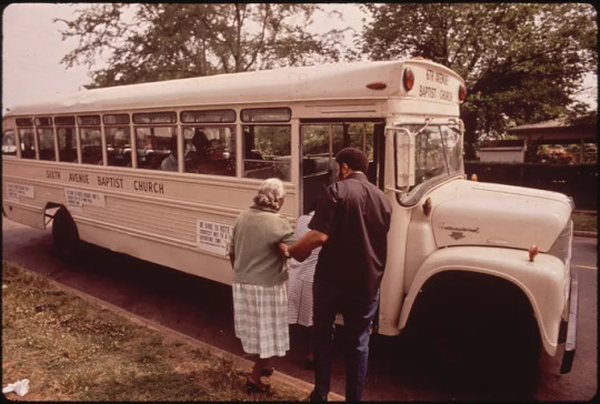
Original caption: "Bus provided by Rev John Porter's 6 Ave. Baptist Church gets voters of Black Community to the polls." Documerica image by LeRoy Woodson, 5/1972. NARA ID 545370.
VOTE TODAY!
Vote in TODAY’S 2022 midterm elections! Haven’t registered or can’t remember if you did? Go to vote.gov. Almost half the states and DC offer same day registration! The National Archives supports Executive Order 14019, which promotes voter registration, participation, and access to voting.
Check out these voting day-related records from our holdings. Might be as good as the “I voted” sticker?


Original Caption: “Baltic, South Dakota, typical of many rural communities...goes to the polls during the November, 1948 presidential election… .Mrs. T.H. Fresdahl, age 82, casts her vote... proud that she has never missed voting in a presidential election since woman suffrage became effective, in 1920.” State Department photo 11/1948, NARA ID 7583488.
Remember: Don’t Sell Your Vote!

USIA poster, 8/6/1953. NARA ID 5729938, emphasis added.
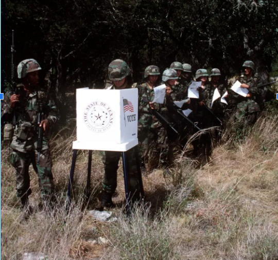
Original Caption: “Members of the United States Air Force with their ballots in hand, are ready to exercise their freedom to vote under field conditions. Airman Magazine photo by John K. McDowell, October 1996.” NARA ID 6499293.

Original Caption: “Tule Lake Relocation Center, Newell, California. Absentee voters of Japanese descent getting ballots and having them notarized.” NARA ID 536513. By Francis Leroy Stewart, 11/2/1942.
More online:
Civics for All of US National Archives' new education initiative promotes civic literacy and engagement.
Voting Rights Special Topics page.
Presidential Elections & Inaugurations Records in the National Archives and Presidential Libraries document elections and inaugurations through history.
Black Americans and the Vote This research portal highlights National Archives holdings that relate to the long struggle for equality in voting rights.
Women's Rights: Suffrage Discover an array of records related to the long quest for women to gain the vote as well as education resources, articles, and blog posts.
Records of Rights online exhibit presents records in the National Archives that document the ongoing struggle of Americans to define, attain, and protect their rights
Rightfully Hers: American Women and the Vote online exhibit highlights the struggle of diverse activists throughout U.S. history to secure voting rights for all American women.
#elections#election day#vote#2022 midterms#civil rights#women#patriotic#rightfullyhers#election history#uselections#gotv#nationalvoterregistration#nationalcivicprideday
109 notes
·
View notes
Photo

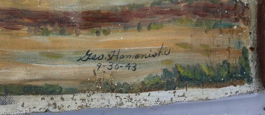
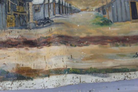
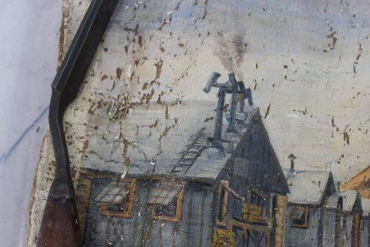
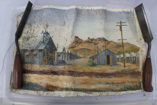
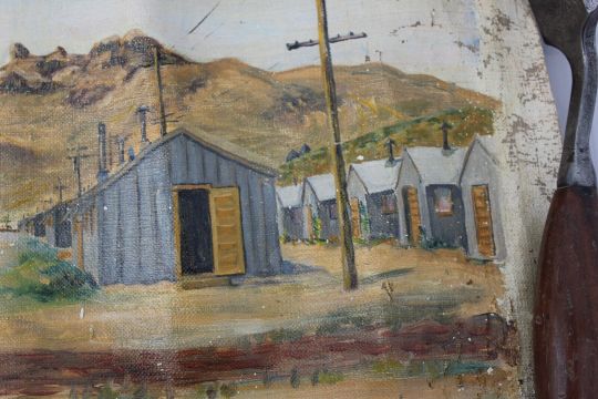
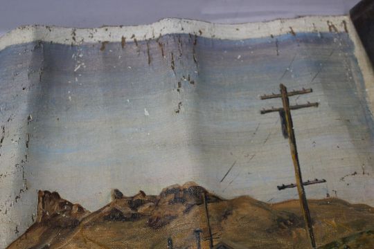

Tule Lake Tulelake Japanese Internment Camp Oil Panting Geo. Hamanishi 1943 ebay mtadamsantique
0 notes
Text
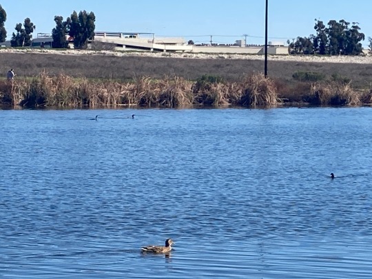
#bird video#nature video#mallards#ducks#anas platyrhynchos#cormorants#phalacrocoracidae#american coot#fulica americana#waterfowl#aquatic birds#tule reeds#aquatic plants#lake#wildlife#sepulveda basin wildlife reserve#van nuys#video
1 note
·
View note
Text
People have worked for a century to make California’s Tulare Basin into a food grower’s paradise. That pastoral landscape now looks more like the Pacific Ocean in many areas.
Months of atmospheric river storms have pummeled the area and saturated the basin’s soil, which sits about halfway between San Francisco and Los Angeles, not far from Fresno. The rains have led to floods that damaged towns and deluged farms and have begun to refill what was once a sprawling lake.
The floods have pitted neighboring property owners against one another and raised tensions over how to manage the flows, which have damaged hundreds of structures. And more water is on the way.
Experts say a monthslong, slow-burning crisis will play out next: A historic snowpack looms in the mountains above the basin — as it melts, it is likely to put downstream communities through months of torment. The flooding, which follows several years of extreme drought, showcases the weather whiplash typical of California, which vacillates between too wet and too dry. The influence of climate change can make the state’s extremes more intense.
“This is a slowly unfolding natural disaster,” said Jeffrey Mount, a senior fellow at the Water Policy Center of the Public Policy Institute of California. “There’s no way to handle it with the existing infrastructure.”
The re-forming Tulare Lake — which was drained for farming a century ago — could remain on the landscape for years, disrupting growers in a region that produces a significant proportion of the nation’s supply of almonds, pistachios, milk and fruit. High-stakes decisions over where that water travels could resonate across the country’s grocery store shelves.
In the farming communities that dot the historic lake bed, accusations of sabotaged levees, frantic efforts to patch breached banks and feuds — common occurrences during flood fights in the area — have started already, said Matt Hurley, a former water manager for several water districts in the Tulare Basin.
n the nearby town of Allensworth last month, a dispute over a culvert caused anxiety and friction with the railroad that sends trains through town. Residents worked into the night to plug a culvert — a drain under Highway 43 — with plywood and sandbags in a desperate effort to keep floodwater out of town.
But later that night, workers with the Burlington Northern Santa Fe railroad unblocked the pipe, which left some Allensworth residents fuming as water flowed closer.
The residents had used BNSF materials without permission, said Lena Kent, a railroad spokesperson. Damming the culvert threatened the highway — the only access point to Allensworth at the time — and the rail tracks that run parallel to it.
Stress levels could remain high for months.
“The problem this year is it’s just begun. We may have water running at or near our flood level — in all of our streams, through August or September,” Hurley said. “This impending monster — a 50-foot-plus deep snowpack that we haven’t seen in 75 years — is sitting up there, and we just don’t know how fast it’s going to turn into water and come out of the mountains.”
The Tulare Basin is at the southern end of California’s San Joaquin Valley — and in essence, it’s a massive bowl. Before irrigators dug canals and rerouted water for farming in the late 1800s, Tulare Lake filled the bowl’s lower reaches. Shallow water stretched across the landscape, and the lake was the largest body of freshwater west of the Mississippi.
Several rivers — Kings, Tule, Kern and Kaweah — historically dead-ended at the lake and replenished its water levels every spring, but farmers have diverted and rerouted so much water that the lake bed is now usually dry. It’s among the most fertile farmland in the country.
Today, the irrigation system is designed to “use every single drop of water” that flows into the basin, Mount said.
In fact, through aggressive groundwater pumping, farmers collectively use more water than what would flow to the lake every year. Pumping has caused the land to sink dramatically — it has subsided in parts of the San Joaquin Valley by as much as 28 feet, according to the U.S. Geological Survey — deepening the bowl.
This season, far more water is flowing than can be used.
For about two weeks, farmers and emergency workers have been scrambling to plug levees and prevent the worst as the ground became saturated and rivers swelled after a seemingly endless series of atmospheric river storms battered California.
The flooding has breached dozens of levees, forced rescues, swamped construction sites at California’s high-speed rail project and seeped into several communities, including Allensworth, a historic community that in 1908 was the first settlement west of the Mississippi to be founded and governed by Black Americans.
“What you’re seeing now more than anything else is traditional flood problems,” Mount said. “All of that water is making its way into the bottom of the bowl and starting to fill the bowl.”
What could come next is more unusual — and worrisome.
The Sierra Nevada mountains, above the Tulare Basin, are storing two to three times as much water as snowpack as is normal. If the snow melts quickly, it will send floodwater churning toward the lake bottom.
Tulare Lake refilled in 1997 and 1983 during very wet seasons. The snowpack is larger this year.
“If we use 1983 as an example: They had more than 80,000 acres of land underwater. If it’s bigger than that, it could be as much as 100,000 acres underwater,” Mount said.
Tulare County ranked second in the country for agricultural market value, according to the 2017 Census of Agriculture. The region produces almonds, oranges, pistachios, wine grapes, milk and cheese.
“This has a ripple effect on the nation’s food supply,” Mount said.
California officials have geared up for a long fight against flooding. Nearly 700 people were assigned to help with the emergency response just in Tulare County, where floodwater has damaged more than 900 structures so far.
But sandbags and helicopter-delivered super sacks — bulk bags filled with rocks and other material — can do only so much.
“At some point, you know, we do realize that there’s too much water, there’s more water in the Sierra than these facilities can handle,” Karla Nemeth, the director of the California Department of Water Resources, said at a recent media briefing. The agency will do the best it could to help mitigate damages, Nemeth said.
Once water makes it to the historic lake bed, there will be few options to remove it, other than to wait for it to evaporate or to try to move it through canals and pump it away.
Pumps are expensive and inefficient over such sprawling terrain. Differing levels of subsidence along the lake bed have changed the geometry of canals, which could complicate efforts to move water away.
In 1983, remnants of Tulare Lake remained on the landscape for about two years, Mount said. Hurley estimated that if it floods again, the expense required to return the landscape to growing crops would be in the billions.
The flooding could also spell disaster for farmworkers and those who live in the rural communities that dot the Tulare Basin.
“This is a low-income community. People are not out here stocking up food. They go paycheck to paycheck in a lot of cases,” said Kayode Kadara, of Allensworth, a community organizer. “All we’ve heard so far is with this unprecedented snowfall, what we’ve seen so far is a baby flood.”
For now, the best everyone can hope for is a cool summer — with a steady, manageable melt — and as much cooperation as they can muster.
24 notes
·
View notes
Text
Map of Runnet
Here's the map of Runnet with all labeled lands and my terrible handwriting!
I also provided some examples of the general landscapes of the regions!
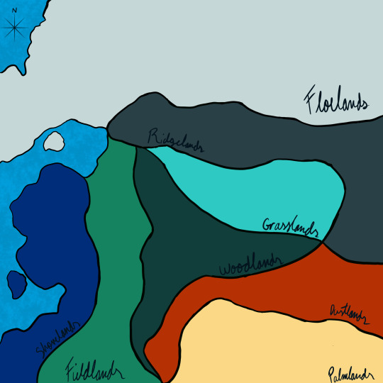
The Grasslands Kingdom
Governing Body: The Royal Family of the Diamants and the Chamber of Merchants
Major Ecosystem: Tall Grass Prairie
Examples: Montana Valley and Foothill Grasslands, Central Forest-Grasslands Transition, Texas Blackland Prairies
The Woodlands Kingdom
Governing Body: The Royal Family of the Emeraudes
Major Ecosystem: Temperate Rainforest and Coniferous Forest
Examples: Northern California Coastal Forests, The Cascades, Atlantic Coastal Pine Barrens
The Palmlands
Governing Body: The Hall of Scholars
Major Ecosystem: Sandy, Hot and Dry Desert
Examples: Mojave Desert, Chihuahuan Desert, Yuma Desert
The Grand Shorelands Temple
Governing Body: The Grand Temple of Astrea
Major Ecosystem: Costal
Examples: Florida Scrub, California Coastal Sage and Chaparral, Hawai'ian Tropical Low Shrublands
The Republic of the Dustlands
Governing Body: The Seven Heads of Council of the Dustlands
Major Ecosystem: Rocky, Semi-Arid Desert
Examples: Colorado Plateau Shrublands, The Painted Desert, Tule Desert
The Fieldlands
Governing Body: Small and Localized to Individual Villages
Major Ecosystem: River Valley and Temperate Broadleaf Forests
Examples: Alleghany Highlands forests, New England-Acadian forests, Western Great Lakes Forests
The Holy Kingdom of the Ridgelands
Governing Body: Church Appointed Monarchy
Major Ecosystem: Mountainous
Examples: Klamath Mountains, Sierra Nevada, Rocky Mountains
The Floelands
Governing Body: Figurehead Monarchy
Major Ecosystem: Tundra
Examples: Alaska–St. Elias Range Tundra, Pacific Coastal Mountain Icefields and Tundra, Arctic Foothills Tundra
#under the eyes of themis#eyes of themis#uteot#image reference#runnet lore#grasslands kingdom#woodlands kingdom#dustlands republic#dustlands#palmlands#fieldlands#ridgelands kingdom#ridgelands#shorelands temple#shorelands#floelands
3 notes
·
View notes
Text
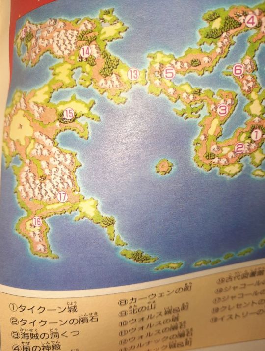

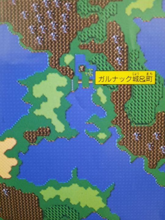


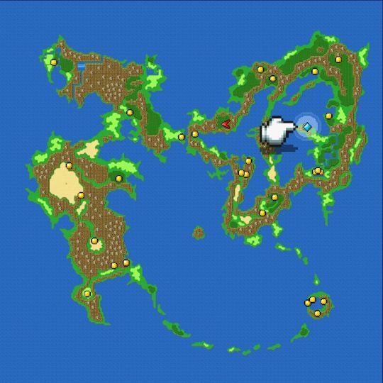
I was getting my notes ready for the next chapter of my novelization when I noticed something odd about the world map I was looking at: there was a mysterious lake north of Jacole that is not there in the game itself. Further investigation into a pull-out map from an activity book from 1992 revealed not just an actual lake, but canals and a lake around Karnak and its town that are no longer there in the final product. Other things of note: the bird-shaped peninsula between Tule and Tycoon is decidedly more beaky than the end result, and the sealed area east-northeast of Tule is smaller. Areas around Tycoon and Walse are much the same as in the game.
The globe projection from the 1992 book Basic Knowledge retains the mystery lake area and beaky peninsula, but loses the canals around Karnak.
This can be excused by the fact that the books are compiled from Famitsu and related magazine articles that were released before the game itself. Several of the books were published in October and November of that year, while the game was released in December.
So, okay, you'd think they'd fix it in future publications, right?
Here is the world map from the PSX-era guidebook:
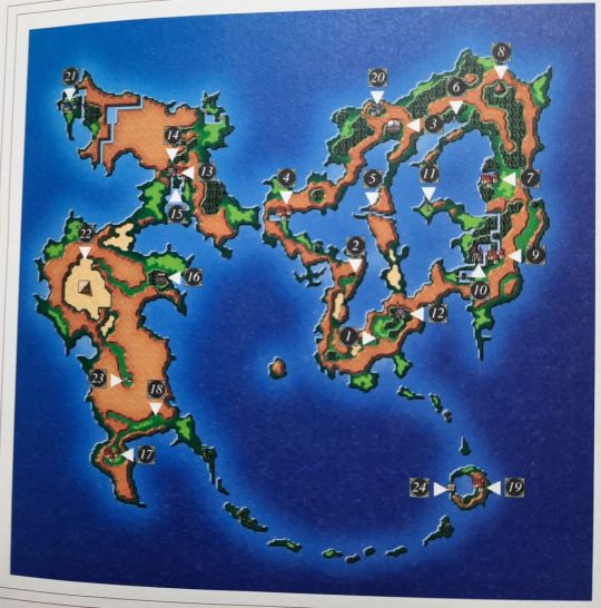
Same mystery lake area north of Jacole, same canals around Karnak, same elongated beak at the peninsula, same smaller sealed area.
The same problem is in the Final Fantasy Complete Works vol. 1, but not the Ultimania vol. 1.
This was fixed in the later GBA publications, but I'm honestly surprised these errors were kept around for so long.
For reference, here's the final product in the Pixel Remaster version on Steam:
As an aside, here are some other things that ended up not being available in the finished product.
2 notes
·
View notes
Text
After President Franklin D. Roosevelt’s Executive Order 9066 paved the way for their removal, Japanese-Americans sold their homes, farms and businesses, often for pennies on the dollar. While incarcerated they worked menial jobs for $12 or $16 or $19 a month — hardly enough to survive on, let alone save for a new beginning. Unable to return to their farms — restrictive covenants and alien land laws often banned Japanese-Americans and their Japanese parents — many who worked on or owned strawberry or lettuce fields before the war moved to Los Angeles and became gardeners, trying to settle into an urban life for the first time in their lives.
Los Angeles, which was home to the largest ethnically Japanese community in North America before the war, was changing, too. The War Relocation Authority, the federal agency tasked with operating the 10 internment camps, worked to empty those camps as quickly as possible following Roosevelt’s closure order in December 1944. The W.R.A. shuttered almost all the camps in the fall of 1945. (One camp, Tule Lake, remained open until March 1946 to house “disloyal” incarcerees.) Each internee received $25 and a train ticket to wherever they wanted to go.
Housing was strained to the seams across the United States, but the situation in Los Angeles, described by one official in October 1945 as “full of dynamite,” was especially dire. More than 1.3 million people — roughly one out of every 100 Americans — moved to California between 1940 and 1944. The California State Reconstruction and Reemployment Commission estimated that 625,000 new homes would need to be built to accommodate the growth in the five years following the war, including 280,000 in Los Angeles County alone. During the war, Little Tokyo first became a ghost town, then swelled with Southern Black workers arriving for defense jobs; for three years Little Tokyo was known as Bronzeville. It was into this chaos that the W.R.A. planned to unload 1,200 incarcerees each week that fall.
By the end of 1945, a month after closing nine of the 10 W.R.A. camps, thousands of Japanese-Americans returned to the West Coast with nowhere to live. Those who couldn’t find other housing took rooms in $1-a-night hostels carved out of prewar hotels and Buddhist temples, or trailers and repurposed Army barracks.
Communities with as many as 1,000 residents filled mazes of barracks and trailers in El Segundo, Hawthorne, Burbank, Inglewood and Santa Monica. Even Lomita Flight Strip, an airfield used to house and train squadrons of P-38 fighter pilots 17 miles south of downtown Los Angeles, was converted into housing. To get into Los Angeles to find work required 85 cents each way, and a four-hour round-trip by bus. Charlotte Brooks, a historian, described the camps as “isolated ghettos that perpetuated the hardships of incarceration.”
— For Japanese-Americans, Housing Injustices Outlived Internment
#bradford pearson#for japanese-americans housing injustices outlived internment#history#racism#housing#ww2#internment of japanese americans#executive order 9066#usa#asian americans#japanese americans#los angeles#california#little tokyo#camp tulelake#war relocation authority#charlotte brooks
4 notes
·
View notes
Last Seen Blogs

danganrequests
DR Requests

kiraridhyan
~ Dhy ~

bhorror
The Working Copy

meliarosee
voci di emozione

aikatsu-motivational-posts
Aikatsu! Motivational Posts