#el hierro
Text
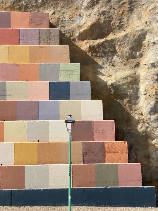
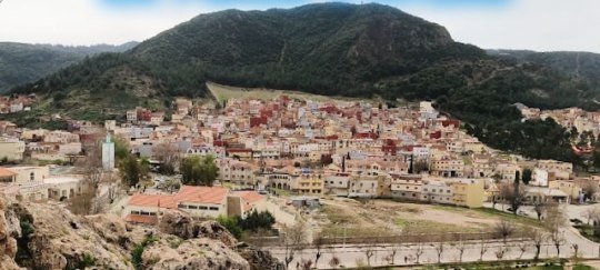
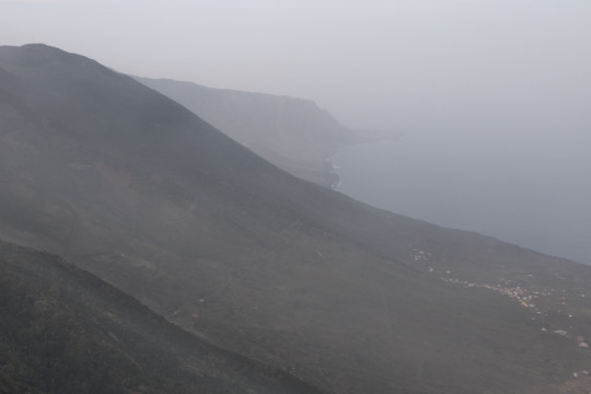
El Hierro. Canary Islands.
#carmen nuñez#woman photographer on tumblr#Valverde#el hierro#iphone#canary islands#photographers on tumblr#october#2023
172 notes
·
View notes
Text
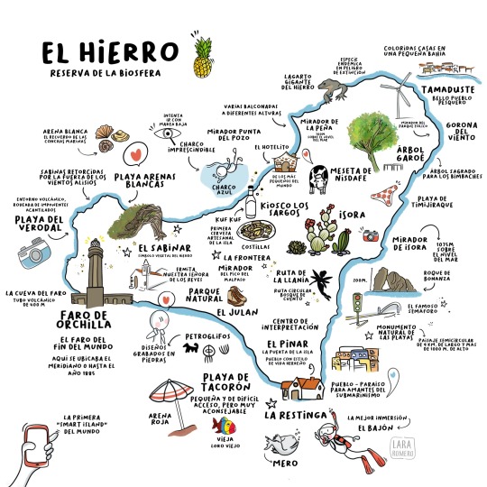
#ipad#idibujos#dibujo#app#ilustración#dibujos#idibujo#pensamientovisual#mapas#mapas ilustrados#Canarias#islas#el hierro
464 notes
·
View notes
Text
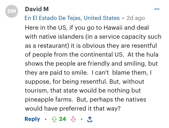
TOURISTS GO HOME
The government doesn't listen to us, we need to boycott tourism in the islands and we beg tourists to stop coming.
For the record, these are some of the comments:


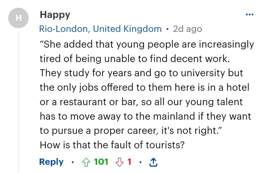


We aren't a theme park
We aren't fucking holiday islands
We are not your fucking bartenders
We aren't your colony
People live here
Tourism DOES NOT PROVIDE TO THE LOCALS
Most of the business that work in tourism aren't even based in the islands, it's from the mainland, German businesses and other nationalities
The Canary Islands are one of the poorer zones of spain
And the most important thing is that we are islands: our territory is very limited
Do you know what happened roughly after a year of a volcano eruption that got rid of whole towns and suddenly people lost everything?
A Resort got announced
Luxury apartments
Everything destined to tourists
Meanwhile there's still people with no house to live in due to the volcano eruption
Our government is full of greedy pigs that won't do shit
We don't care if this offends you, as a tourist. We believe in another form of tourism, but not this massive one.
It's not normal we have the same density of poblation of Japan
It's not normal we hold 14 million tourists a year
It's not normal everyday there's news about some tourists going into reserved areas zones protected by the biosphere and messing them up
It's not normal there's more and more new hotels getting built in areas that are supposed to be protected
The manifestation and riot is the 20th April
#canary islands#tenerife#tourists go home#tourism#20A#gran canaria#la gomera#el hierro#la palma#lanzarote#fuerteventura#la graciosa#islas canarias
7 notes
·
View notes
Text
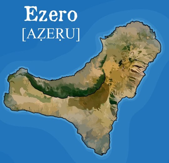
EZERO, NOMBRE ABORIGEN DE LA ISLA DEL HIERRO
Ezero, el nombre amazigh de la isla de El Hierro
Imagen: CAUCE Gobierno de Canarias
IẒUṚAN. La isla de El Hierro es la más meridional y occidental de Canarias. Además es la que cuenta con una menor superficie terrestre (269 km²) de las siete islas mayores siendo una de las más jóvenes geológicamente hablando. La isla, hoy Reserva de la Biosfera, estuvo habitada antaño por una población amazigh denominada bimbaches o bimbapes, por lo que podemos considerar a este territorio como punto más occidental del viejo mundo amazigh.
La huella de esta población en la isla es palpable, no sólo por los restos arqueológicos o la notable densidad de inscripciones líbico-bereberes (más de 100), sino por los elementos culturales vivos heredados por la población herreña actual; abundante toponimia y léxico amazigh, así como en aspectos de las costumbres ganaderas, gastronomía, artesanía, deportes y posiblemente folklóricos.
Pero ¿Cómo llamaron los bimbaches a su isla?
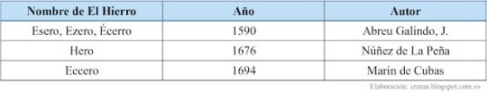
Autores del siglo XVI y XVII dan variantes de la que parece ser una única denominación; Esero, Ezero, Écerro, Hero o Eccero. Es Abreu Galindo el que más detalles nos aporta incluyendo la traducción de ‘fuerte’, el en sentido de fortaleza natural;
Abreu Galindo, J. (1590 ed.1848:46)
Poblado de Guinea en la isla de Ezero. Foto: MAURITIUS IMAGES GMBH.
Otros ejemplos en el país
Para explicar este significado, Abreu lo relaciona con el topónimo palmero Acero, que correspondió a la zona central de la isla de La Palma hoy denominada Caldera de Taburiente, otorgándoles idéntico significado:
"(…) Acero, que al presente llaman la Caldera, que en lenguaje palmero quiere decir 'lugar fuerte', que parece significar lo mismo que en lenguaje herreño Ecerro". “(El nombre) está bien adaptado al lugar, porque es casi inexpugnable; y así fué lo último que se ganó de la isla (Abreu Galindo, 1590 ed. 1977:268). "Este término de Acero se llama al presente Caldera, porque su hechura es en forma de caldera, toda a la redonda cerrada de muy altos riscos y laderas, que bajan en forma de cerros a lo bajo de ella" (ibíd.: 284).
Los abruptos riscos de la Caldera de Taburiente vistos desde el interior. Foto: paisajesdeordesa.com
Aunque podría considerarse que el topónimo no llegó hasta nuestros días por transmisión oral, quizás en otros rincones del archipiélago sí fue posible. Así lo creen algunos autores que advierten del topónimo Acero o Asero en varias ubicaciones de Tenerife (Barranco de Acero entre Icod y Garachico, Lomo de Acero en Arico, y Barranco de Acero en Santa Úrsula añadimos nosotros), de La Palma (Cuevas de Acero, en Barlovento) y Gran Canaria (Cuesta de Acero, en Moya). Trapero lo explica de la siguiente manera: "Nos parece imposible que este término toponímico canario se corresponda con la voz española acero (...) Más bien creemos que debajo de esa escritura subyace la forma /aséro/". No obstante, debemos ser prudentes pues el apellido Acero existe y puede ser el motivo de estos topónimos actuales o de alguno de ellos.
Por nuestra parte, consideramos que el plural de Ezero o Acero lo encontramos en los topónimos Isora; un malpaís en el suroeste de Tenerife (en el actual Municipio de Guía de Isora), una zona en Tegueste y una localidad en la propia isla de El Hierro.
¿Qué nos dice la tamazight actual?
Topónimos como este, documentados y tan bien explicado por un cronista, desafortunadamente no son los más habituales en Canarias. Además, la lingüística comparada con las variedades de la tamazight actual del continente arrojan bastante luz al respecto dando la razón a Abreu tanto en la relación entre el Ezero herreño y el Acero palmero como en el significado del mismo.
Ya Wölfel, en su tiempo y con sus enormes limitaciones, lo relacionó con la voz panamazigh aẓṛu ‘roca’ y el tuareg aẓeru ‘muralla rocosa en pico’. En similar dirección apuntaron posteriormente Ahmed Sabir (2001) y Reyes García (2003). Sabir explica que el significado de aẓeru (plu. iẓeran) es idéntico puesto que “por derivación semántica la voz aẓeru ha venido a significar en tachelhit ‘lugar fuerte’, por alusión a la materia con que está edificada; por ello la voz aẓeru se convierte en sinónima de agadir e igherm”. Por otro lado, Reyes considera que es más preciso relacionarla conla voz tuareg aẓeru ‘muralla rocosa alta y vertical’.
Como complemento, también debemos añadir que la voz aẓṛu es habitual en la toponimia amazigh de países vecinos como Marruecos, Argelia, Túnez o Libia haciendo referencia a montañas o roques, algunos vinculados con las creencias preislámicas.
Panorámica de la ciudad marroquí Azrou [Aẓṛu en amazigh] a 1250 mts en la Cordillera del Atlas. Su nombre se debe al enorme roque que rodea la urbe.
Conclusiones
Como describen las fuentes documentales y confirma la lengua amazigh, el nombre ancestral de la isla de El Hierro fue Aẓeṛu (voz castellanizada por los cronistas como Esero, Ezero, Écerro, Eccero o Hero). Este término amazigh abarca un campo semántico concerniente a ‘piedra, roca, roque’ pero que, en este caso, debe traducirse como ‘lugar fuerte’, es decir, un lugar especialmente abrupto y rocoso que conforma una fortaleza natural.
REFERENCIAS
-Abreu Galindo, J. Historia de la Conquista de las siete islas de Gran Canaria.
- Akli Haddadou. Dictionnaire des racines berbères communes.
- Álvarez Delgado, J. Etimología de Hierro (Eres o Heres). Revista de Historia de la Universidad de La Laguna.
-Reyes García, I. Diccionario Ínsuloamaziq. On line.
-Sabir, A. Las Canarias prehispánicas y el Norte de África. El ejemplo de Marruecos.
-Trapero, M. Toponimia ULPGC.
Publicado por IZURAN en 23:23 Enviar esto por correo electrónicoBlogThis!Compartir en TwitterCompartir en FacebookCompartir en Pinterest
Etiquetas: El Hierro-Aẓeṛu, Lengua~awal

Iẓuṛan Canarias
🔥La isla de El Hierro es la más meridional y occidental de Canarias. Además es la que cuenta con una menor superficie terrestre (269 km²) de las siete islas mayores siendo una de las más jóvenes geológicamente hablando. La isla, hoy Reserva de la Biosfera, estuvo habitada antaño por una población amazigh denominada bimbaches o bimbapes, por lo que podemos considerar a este territorio como punto más occidental del viejo mundo amazig.
https://izuran.blogspot.com/2023/06/el-nombre-amazig-de-la-isla-de-el-hierro.html?fbclid=IwAR34QAlnYVWaHArKgMLsEd7FcP7kYIMGAn7BQKnSp1WQbiNv16GudCxrZuA
https://www.facebook.com/izuran.canarias/posts/pfbid01QsFcv3AcdiFzvS8mQLtCx4NwX58DNecBmi584SPFyVrspnMT4C1C9eyJV3g9z5il?__cft__[0]=AZVSdKwtabcmhDN3OJbkuu4m5BmiVTL1DyJ1vIs-IEt55bBVqCKue_MFmLl6mSHXPps7P4hK3XKqxH8uoNH3aO1RS2gVLMbbDspd3w_sGS_BcS35B5aQnFjVhsz3FyhDroi8e2b5rYqm9ewqHrlRMhvY5qY6wQUFUvGjmgVM80Gyag&__tn__=%2CO%2CP-R
#izuran#ezero#el hierro#aborigenous#indigenous#culture#history#genocide#native#unesco#united nations#canary islands#international criminal court#cou penal international#corte penal internacional#islas canarias#naciones unidas#nativos#genocido#historia#cultura#indigenas#aborigenes#canarias tiene identidad cultural propia#canarias la colonia mas antigua del mundo#descolonizacion de canarias#canarias#onu#icc#amazigh
6 notes
·
View notes
Text


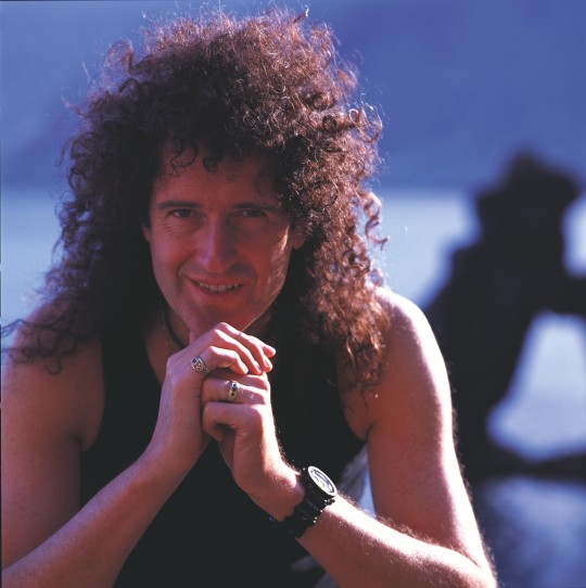
Brian May in the Canary Islands of Spain, 1998. All photos are from the 'Another World' album photoshoot, taken by Richard Gray.
If some of you folks have been wondering where exactly in the Canary Islands you can find the giant cacti or where the unique rock formation is...
The giant saguaro cacti can be found in Fuenteventura.

(source: https://steemit.com/photography/@outerground/land-of-the-giant-cacti-fuerteventura-canary-islands-photo-essay)
And the rock formation is called Roque De La Bonanza, located in the midst of Las Playas...

source: https://elhierro.travel/en/what-to-do/roque-de-la-bonanza/)
16 notes
·
View notes
Text
Seven beautiful wildflowers rising from the bottom of the ocean

Gran Canaria
The Canary Islands have as many names as they are diverse, the entire archipiélago is an astonishing patchwork of extreme wild landscapes and micro-climates.
Apart from that they have a generous supply of small paradises, surprises and adventures alike.
The group of seven islands, seven wildflowers, off the coast of North-West Africa are blessed with a warm subtropical climate, all year long, an eternal spring!
It is difficult to find words to describe their beauty, each one is a volcanic jewel, a priceless treasure.
The islands are just the top of a gigantic subaquatic mountain chain, rising a phenomenal 7.500 metres from the bottom of the Atlantic Ocean, as a result of ferocious volcanic eruptions.
The Canaries have a particularly interesting history, dramatic geography and is a veritable goldmine of fascinating and surprising small sites.
The islands are themselves a revelation, unique and dissimilar from anything else in the world.
In addition to being distinct from anything you have ever seen they are also different from each other.
The Canary Islands are located 100 kilometres (62 miles) from the African coast, and an astonishing 1.056 kilometres (1.700 miles) from the Spanish mainland, even though they belong to Spain.
The archipiélago consists of seven larger inhabited islands or thirteen including the smaller uninhabited ones.
As each island is unique, and differs greatly from the others, a deeper description is needed to familiarise oneself with each island, representing each one by a special Canarian wildflower, so we can discover the flora a bit more too. The islands are ordered from oldest to youngest.
Fuerteventura
The island of the golden beaches
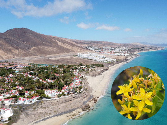
Fuerteventura beach and Hypericum Canariensis
Fuerteventura is the oldest of all the islands in the archipelago, and is at its ripe age a paradise of beaches.
The island lacks some of the enormous mountains and high peaks that characterises many of its sisters but instead its topography is perfect for a myriad of water activities, such as : snorkelling, windsurfing, kite surfing, yachting, sport fishing and waterskiing.
The beautiful sandy island of Fuerteventura has a rugged beauty, exceptional beaches and a dramatic coastline, it is the second island in size after its bigger neighbour Tenerife.
The entire island has been declared a biosphere reserve, thanks to the diversity of its flora and fauna, its many microclimates are evident all around the island.
Its name is subject to wide discussions, Fuerteventura in Spanish means “strong winds” a reference to the windy conditions around the island that sometimes endanger nautical adventurers.
However, it might also refer to wealth, luck or destiny, a third theory suggests that the name derives from Latin “Fortunatae Insulalae” (fortunate islands).
In ancient times it was called Maxorata which means “children of the country” in ancient Canarian Berber, by the native inhabitants, the Guanches.
Lanzarote
The Island with the moon landscape
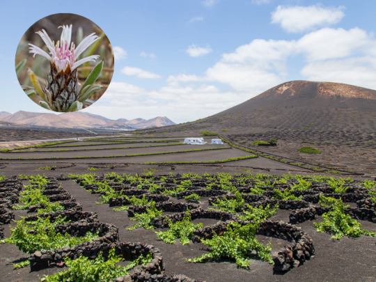
Grape trees in Lanzarote and Attaraylis Preauxiana
The distinct arid island of Lanzarote offers a volcanic moonscape, best compared with the actual landscape of the moon.
Nevertheless, it also has its invisible secrets, El golfo cráter is a volcanic crater on the shore of the peculiar island.
Inland, just a few metres from the coast, is a pool of water that has developed a green hue. The green comes from an algae living in the salt water in the pool.
The waters in the pool are still connected to the ocean via underground fissures, which keeps the water at sea level, and ensures that the pool doesn’t evaporate away.
Cooking food over a volcano.
On Lanzarote where the last volcanic eruption took place in 1824 there is still a significant amount of heat just below the surface.
In the National Park of Timanfaya you can visit a restaurant * , with a nine metres hole, dug to access the heat, and is used to grill.
The temperature of the grill reaches 400 degrees C and uses no energy.
Further, the island has some of the oddest vineyards in the world, as the island is volcanic, arid and has almost no soil or natural vegetation, to grow grape vines here takes quite a bit of effort.
Unlike most vineyards, where vines are planted in rows, on Lanzarote each vine is placed in a small depression with a semicircular wall of lava stone around it, to help protect it from the winds. The plants take root in the lava rock, where they get water from the moisture that condenses on the rocks.
Gran Canaria
The miniature continent

Roque nublo, Gran Canaria and Helianthemum inaguae, plant species considered in danger of extinction
Gran Canaria has a landscape forged by volcanoes.
The island rose from the bottom of the sea as a result of the force of volcanoes.
Then the volcanoes, the winds and the rain came together and sculpted the island of cliffs, fertile plains, deep ravines, black and golden fine sand beaches, natural pools, galleries, caves, stone arches, valleys and monoliths.
Such a geographical diversity of microclimates makes it possible for Gran Canaria to have so many different faces.
From its high altitudes, when looking down from the Pico de las Nieves (the snowy peak) and feeling the vertigo, as you stand at an altitude of almost two thousand metres the island looks very different from what it does when you see it from the coast, while hugging the ocean.
But it is the same island nonetheless: the heir of the volcano.
Today as the volcano has been sleeping for millennia and we can approach it without fear, we can see the island's volcanic heritage reflected in its nature.
Even higher up, where the island pierces the sky, lies the protected landscape of Las Cumbres de Gran Canaria (the summit), the high mountain region where a series of volcanoes that erupted three thousand years ago are aligned.
Inside the protected landscape of the sacred mountains of the island, declared a World Heritage site by UNESCO, we can observe the indigenous heritage the way natural caves or caves made by humans in the volcanic tuff were used as dwellings, barns, astronomy sites or sacred places for rituals.
These high peaks, covered in pine forests, marks the separation between the semi-deserted south and the lush, densely vegetated north.
When seeing the different climates, so paradoxical, like opposites, that is when you realise that this small island is truly home to several worlds, a continent in miniature.
Tenerife
Starry nights on Mount Teide

Mount Teide and Tajinaste rojo
Tenerife is the largest and most populated of the tropical archipelago, with a generous variety of landscapes: golden sand beaches, misty volcanoes, and a dense pine wood.
Mount Teide is not only the highest point in the entirety of Spain and the world’s third highest volcano, but with its peak measuring an astonishing 3.718 metres above sea level ( 7.500 metres from the ocean floor ), it also casts the longest shadow over the sea in the world. It is spectacular!
As that is not enough, Teide’s national park is the most visited park in all of Europe and it is, of course, home to Mount Teide, as well as a Natural World Heritage site.
Furthermore, Mount Teide literally separates the island in two different climate zones: the semi-deserted south and the rich, flourishing northern parts.
The waters in the southwest of the island are exceptionally rich in marine life and one of the few places in the world where you can actually see and interact with turtles and dolphins that live here all year long. This region is also visited by blue whales and orcas.
A true sanctuary for these incredible mammals that find ideal conditions for feeding and reproduction here.
The curious shadow of Mount Teide
The Canaries are due to their location, climatic conditions and mountain peaks blessed with the clearest and most unpolluted skies, excellent for stargazing, in the world.
In addition, Mount Teide has another secret: when the sun rises the Mount casts a curious pyramidal shadow over the Atlantic Ocean which disappears into the distance like a train truck.
The shadow changes as the day grows.
At dawn a silhouette is projected towards the island of La Gomera, while at dusk the shadow is pushed out towards Gran Canaria.
Views of the shadow are particularly good from the peak of Mount Teide itself. The silhouette on the ocean is in the shape of a perfect geometric triangle, which is astonishing especially as it is considered that the actual peak of Mount Teide does not have a pyramidal shape at all.
The shadow therefore seems to defy reason.
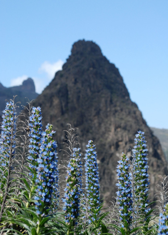
La Gomera
The forgotten island that was lost in time
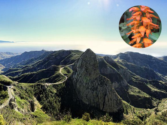
La Gomera and Digitalis (Isoplexis) canariensis
From a distance La Gomera appears as an impenetrable fortress, ringed with soaring rock walls. Noodle thin roads wiggle along cliff faces, and up ravines.
The white spots on this prehistoric landscape turns out to be houses impossibly placed on inaccessible escarpments.
Up close, however, the rough landscape turns out to be lush valleys, dense rainforests, glittering black pebble beaches and bold rock formations sculpted by volcanic activity and erosion.
Simply put, La Gomera’s shape is rather like an orange that has been cut in half then split into segments, which has left deep ravines or barrancos in between them.
By the coast beaches are set between the cliffs, this wild, mountainous landscape is filled with contrasts, it is a paradise for nature lovers.
Considering the inaccessible landscape it is not difficult to understand why the thousand years old whistle language still is especially deep rooted here.
They really needed it to communicate through rough mountainous terrain, and it has lived on since ancient times until now.
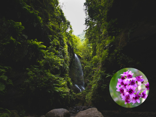
La Gomera’s prime attraction is the magical often misty National park “Garajonay”.
Clever though by gorges and filled with laurel rainforest, this prehistoric forest is responsible for the labyrinth of vegetation in the park, a park that is bewitching like a fairytale.
Here you will find more than a thousand species that, thanks to their isolation, include a large proportion impossible to find elsewhere.
Lush and dense laurel rainforests once grew across most of Southern Europe and North Africa but now they are only found here in the Canaries and the rest of Micronesia.
An interesting note, La Gomera is the only island that still uses its ancient native “Guanche “ name.
The legend of Gara and Jonah
The Canarian Romeo and Juliet
The Canaries is famously known as the land of legends and volcanoes, this special legend comes from La Gomera.
Long, long time ago, in the time of the Guanches, the first native of the archipiélago, a beautiful princess lived in La Gomera, her name was Gara.
This island was famous for its water springs that still exist (los chorros de Epina), which could predict if someone would find true love: if the waters remained quiet, without movement, it meant The person would find true love but if the waters got turbulent, the answer was negative.
During the Guanches New Year's feast, princess Gara and her friends visited the spring, as Gara approached, the still water started to become so turbulent that it was shaking, then a sun appeared in the waters and told her: What will happen will happen, run away from the fire Gara, or it will consume you.
The same day, Jonay, a handsome young Guanche and son of the king of Tenerife, visited the island with his father and other noblemen as they were invited to the new year’s feast in La Gomera.
When their eyes met, it was love at first sight!
They immediately announced to their parents that they wanted to get engaged.
It was then that the ocean got filled with fire, the big, powerful volcano Teide on Tenerife had erupted, and such was his fury that you could see it even from La Gomera.
That was when they remembered Jonay was from Tenerife, the island of fire and Gara was the princess of the holy springs.
Fire and water don’t mix! Their love was impossible.
It was first when their parents forbade the engagement that the volcano calmed down.
Back in Tenerife, Jonay couldn’t forget Gara and in the middle of the night he threw himself in the ocean and swam across to the island of La Gomera and Gara, where he and Gara ran together up the mountains, to the very highest top but as they discovered they were followed they took a stick and sharpened its two extremes.
Holding it in between themselves to their chests, they hugged, the sharpened stick pierced their hearts and they died together.
Since then the mountain is called Garajonay, in memory of the two lovers that preferred death rather than continue living separated.
This same place is nowadays a National park: "Garajonay”.
La Palma
The beauty (La bonita)
La palma and Pericallis hadrosoma
There are places that will give you unique, magical moments, moments when you think: this is what I always wanted to experience, places made just for you.
La Palma is one of those places.
From the top of the mountains you get a spectacular view, and if that is not enough you might even, if you are lucky, get to see a sea of clouds.
The heat from the sand almost burns your feet but the cool waters from the Atlantic quickly repairs the damage.
The pleasure is complete with the calming, soft and fresh scent of canary pines, from the abundant pine woods, that fill your senses and relax your body.
The beautiful, green La Palma is like a big, natural spa!
A natural spa that regenerates, revitalises you, and fills you with energy and good vibes.
It is mainly in December and January that snow appears on the highest points of the island, surrounded by pine trees.
With the top of the island covered by a white snow blanket, you wonder: is this really a subtropical island?
It is even possible to enjoy a snowball fight in the morning and finish the day with a warm, relaxing sunset swim in the Atlantic, life can not get much better than that!
El Hierro
The island with soul
Tajinaste Azul
It is the youngest and it is tiny but overfilled with incredible natural wonders.
El Hierro is indeed the smallest of the fortunate (inhabited) islands, but it is an island with soul.
The island is more remarkable for what it doesn’t have than for what it has.
There is very little traffic here, the island has no hotel complexes, no buildings higher than two floors, no lifts and only one set of traffic lights.
Furthermore, it is almost completely self sufficient.
Since a while back El Hierro has been working towards making the entire island self-sufficient and they have almost reached their goal, other islands are following their example but are somewhat behind.
Beaches here are rare, to swim you either have to jump from the cliffs or enjoy the many natural pools, as a substitute for beaches, but the island's wonderful landscapes make up for the lack of beaches.
Ancient civilizations were just as impressed and fascinated by this array of exotic islands as we are today.
The archipielago forms a part of the Macronesian eco region and it is further referred to as “the islands of eternal spring” , the reason for that is that they are regulated by the Gulf Stream and trade winds, which contribute to their subtropical climate.
With little difference between seasons, they truly have an eternal spring!
Loved by countless civilizations, each one giving them a nickname, the islands have got as many names as there are stars in the sky, we find many names for those we love!

Tenerife
Canary Islands- the Romans.
The fortunate islands-the Numidians
The islands of eternal spring - the Greeks.
The everlasting islands- the Arabs.
The blessed islands-the phoenicians.
The islands of the fortunate-
The islands of the Guanches-the Guanches.
The islands of hope-
The Macronesian islands
The canary birds were named after these islands and not the other way around.
Caught in between volcanoes, legends and reality, they are marvellous islands on the limit of the world.
The sweet charm surrounding them and their positive energy works as a magnet!
You visit once and you are stuck, you fall in love and nothing else is comparable.
Their diversity is staggering, no other place in the world offers so many treasures compressed in such a small place.
It is truly an archipelago of a thousand experiences!
*El Diablo restaurant in Timanfaya.
#history#writers on tumblr#writblr#writers#original content#travel#spain#the canaries#canary islands#canarias#gran canaria#tenerife#fuerteventura#lanzarote#la palma#la gomera#el hierro#flowers
29 notes
·
View notes
Photo


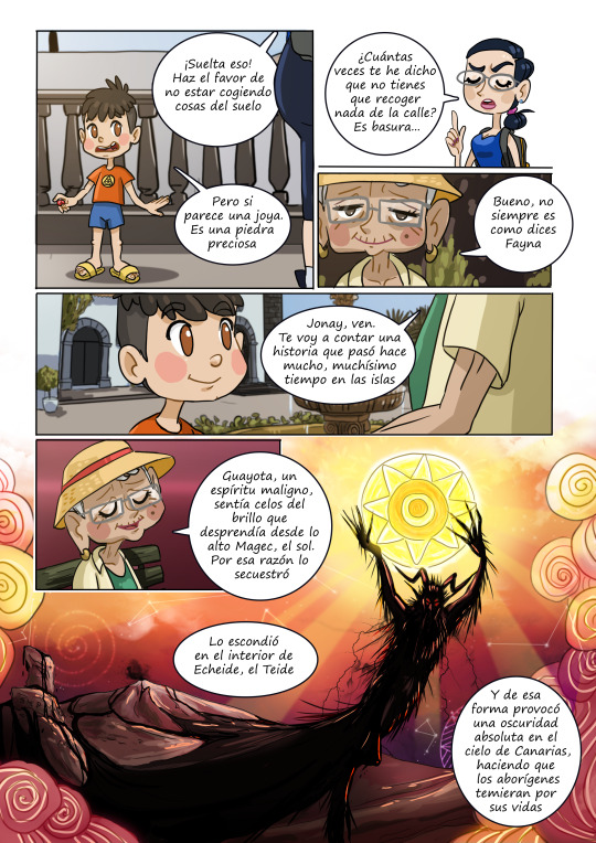
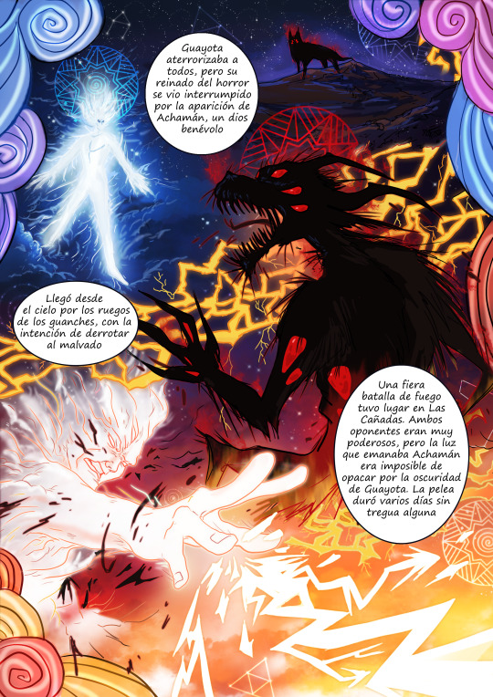
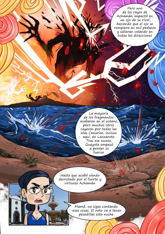
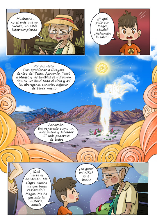

El ojo de Guayota
2° premio del XIV Edición Certamen Crea Joven San Bartolomé 2022
Una familia tinerfeña está de viaje en Lanzarote y, a su paso por San Bartolomé, la abuela le cuenta a su nieto una cuento sobre mitología canaria.
En agosto se me ocurrió la idea, en seis días dibujé, escribí, coloreé y maqueté este cómic, y mira por donde ha quedado segundo a nivel regional
https://www.instagram.com/jonas_emanuel_ilustrador/
#guayota#achaman#islas canarias#myth#comic#mitologia#mito#tenerife#teide#tebeo#gran canaria#el hierro#la palma#lanzarote#fuerteventura#la gomera#god#devil#demon#illustration#ilustracion#spain
7 notes
·
View notes
Text

#teneriffa#mallorca#kanaren#la palma#kanarischeinseln#grancanaria#la gomera#el hierro#lanzarote#fuerteventura#familienurlaub#Senioren Urlaub#Golfreise#strandurlaub#urlaub mit hund#wanderurlaub#ferienhaus#ferienwohnung#luxus
0 notes

Text
Wohin mit der vielen Vulkanasche?
La Palma sucht Möglichkeit, die Vulkanasche zu verwerten –
Die Menge von Vulkanasche nach dem Vulkanausbruch des Tajogaite im Jahre 2021 ist ungeheuerlich. Über eine Fläche von mehr als 3.000 Hektar liegen mehr als zehn Millionen Kubikmeter aus geschleuderte Asche auf der Oberfläche der Insel. Das ergaben auch Messungen des Copernicus-Satelliten.
Viele unbeschädigten Fincas und Häuser wurden…

View On WordPress
0 notes
Text
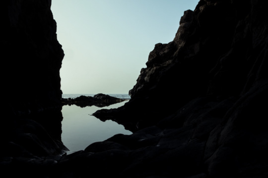
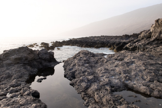
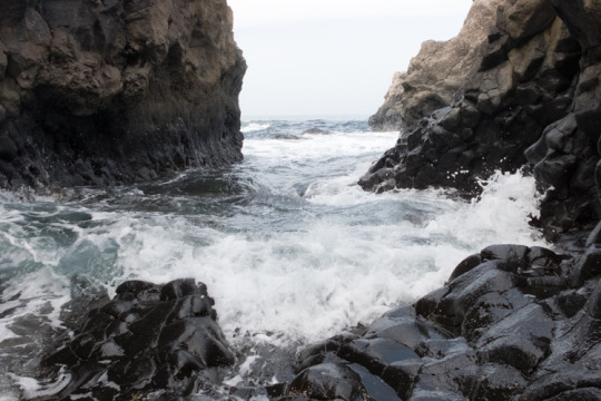
El Hierro
#carmen nuñez#woman photographer on tumblr#la restinga#el hierro#canary islands#iphone#photographers on tumblr#october#2023
113 notes
·
View notes


Text
DESTRUCCIÓN ARQUEOLOGICA
Cristo Cruz
INSCRIPCIONES "NUMÍDICAS" CONVERTIDAS EN GRAVILLA PARA UNA CARRETERA.
(El Hierro)
Extracto de un artículo publicado en Gaceta de Tenerife en el año 1931:
«Los letreros de la Caleta resistieron decenas de siglos la acción de la intemperie y estaban para durar todavía muchos años; pero salió a remate la carretera de la Estaca, y los bloques de basalto cubiertos de inscripciones numídicas fueron transformados casi totalmente en gravilla para el afirmado de la carretera. ¡Maravilloso procedimiento de convertirlos en objeto de público utilidad!
Por lo visto, nadie se enteró hasta que el hecho estuvo consumado; después ha quedado un recurso: lamentarlo, calificándolo de barbarie.
Yo también lo lamento, pero no me parece adecuada la calificación; la barbarie me parece que supone un cierto conocimiento del valor de lo que se destruye; éste es un simple caso de ignorancia, con funestas consecuencias, por el absoluto abandono en que se ha dejado esta clase de monumentos en nuestras islas. ¿Vamos a pedir a un contratista de carreteras o a un capataz de peones camineros que aprecie en su justo valor arqueológico unas inscripciones rupestres por muy numídicas que fueren? El contratista ve en aquellas rocas un magnífico material para sus obras; unas rocas que no producen nada, que no están acotadas ni segregadas por señal alguna de las otras rocas que forman los acantilados de la costa: en cambio, están muy cerca de las obras que realiza: utilizarlas, le supone una gran economía de tiempo y de acarreo; y el contratista, que tendrá una gran ignorancia arqueológica pero posee una maravillosa intuición económica, no se detiene por cuatro letras más o menos, y convierte las rocas en gravilla.
La calificación de barbarie, y precisamente de aquella variedad que llamamos vandalismo, la reservo yo para aquellos "antropólogos" insulares que, por su propia mano, o por la de cazurros estimulados con dinero, destruyeron cuevas, casas, enterramientos, reliquias arqueológicas de todo género sin recoger un solo apunte, y por satisfacer la vanidad de enviar huesos de guanches al doctor Broca, o formar colecciones de cráneos cuyo verdadero valor desconocían; y para los que, destruyéndolo todo, buscaban momias que vender a los museos extranjeros.»
- Dr. D. José García Ortega. Gaceta de Tenerife: diario católico de información (1931)
- Imagen: El Eco de Canarias (1977)
https://www.facebook.com/permalink.php?story_fbid=pfbid0DYnwfo6LvobRGHUeVabrUHmqxLnqYEHS9xDE7ReXLPuzZKJnPAeJ97nS2PugajH9l&id=100011806116586&__cft__[0]=AZX7rpb5szyr89TAczxbCMb0X298cdrWTMyIOxzM8UucJvXzcULfbEH4F2eBWuBUDQdpOrBJax-8vahQHVzwdtfBozcLyq2rWByKwH5e3-TcFIyicyQIWwF5FkeK9sYYA0vWRt2J9-uhJanFecWBx2rVZv9TK7P_-QekZPNjpOjuyMgrWn35zRTE1Hef4LajTO0&__tn__=%2CO%2CP-y-R
#el hierro#azero#hero#acero#numidicas#aborigenous#indigenous#culture#history#genocide#native#canary islands#unesco#united nations#international criminal court#cou penal international#corte penal internacional#naciones unidas#islas canarias#nativos#genocidio#historia#cultura#indigenas#aborigenes#canarias tiene identidad cultural propia#canarias la colonia mas antigua del mundo#descolonizacion de canarias#canarias#onu
4 notes
·
View notes
Text

Playa de Los Cancajos - La Palma
www.dosviajerisimos.es
#la palma#islas canarias#canarias#lanzarote#canaryislands#tenerife#elhierro#el hierro#conoce canarias#turismo#viajes#travelgram#travelblog#travel#la gomera#lagomera#dosviajerisimos#playas
1 note
·
View note
Text
El Hierro IV
Creo que nunca he sido mas consciente de lo que esta isla significa para mi, que en este ultimo viaje que me he permitido poder hacer, toda una serie de rincones que, no porque no los hubiera visto ya, no dejan de hacerme sentir especial, por cincuenta mil razones distintas.
Pasear por senderos de piedras que están esperando la menor oportunidad para romperte las suelas, hacerte tropezar y darte…
View On WordPress
0 notes
Photo

THE CANARY CALLS — HOLIDAY IN THE ISLANDS
Read More @ https://www.7seasholidays.co.uk/the-canary-calls-holiday-in-islands/
#Lanzarote#Fuerteventura#gran canaria#Tenerife#la gomera#la palma#El Hierro#la graciosa#canaryislands
0 notes
Last Seen Blogs

seelf-mutilatioon
AUTOMUTILACION


schrodingersdickhead
eridan

adelrambles
Adelram's Ramble Box (Now in HD!)

photmath
em